
A few valuable boating apps, and what’s your favorite?
Most boaters carry around an impressively powerful and easy to use computer in their pockets: their smartphone. Smartphones have enough processing power, sensors and capabilities to augment or possibly even replace dedicated navigation equipment onboard your boat. Mobile phone and tablet apps for boating have steadily improved and today offer a compelling set of functionalities that can make boating both safer and easier.
To me, one of the key benefits of mobile apps at the helm is the ability to use multiple brands of charts. Using different chart providers helps avoid falling victim to any issue with your charts. What follows are examples of what’s possible with mobile apps across several categories. This list isn’t exhaustive and that’s not the intention. The list of mobile apps is extremely long with more coming out every day. Each category mentioned here has dozens to hundreds of apps.
Although the functionality of mobile apps has reached the point where they are capable of replacing multi-function devices (MFDs) and other equipment, I still believe boats should have at least one dedicated marine-display onboard. Mobile devices are much more susceptible to moisture, heat, dead batteries, and falling overboard than single-purpose hardware installed on the boat. In my own cruising, I’ve dealt with apps crashing, batteries dying, and overheated iPads shutting down from sitting in direct sunlight. But, as a supplement or backup to dedicated devices, mobile apps deliver impressive capabilities.
Navigation Apps

In the last decade navigation apps have matured to the point today where their features and functions rival, and in some cases even beat dedicated hardware. One of the biggest advantages a mobile device has (whether it’s a phone or tablet) over installed hardware is an (almost) always available internet connection. This connection makes updating charts and other data easier. Installed hardware requires multi-step processes to update data and in practice often results in less frequent updates of this data.

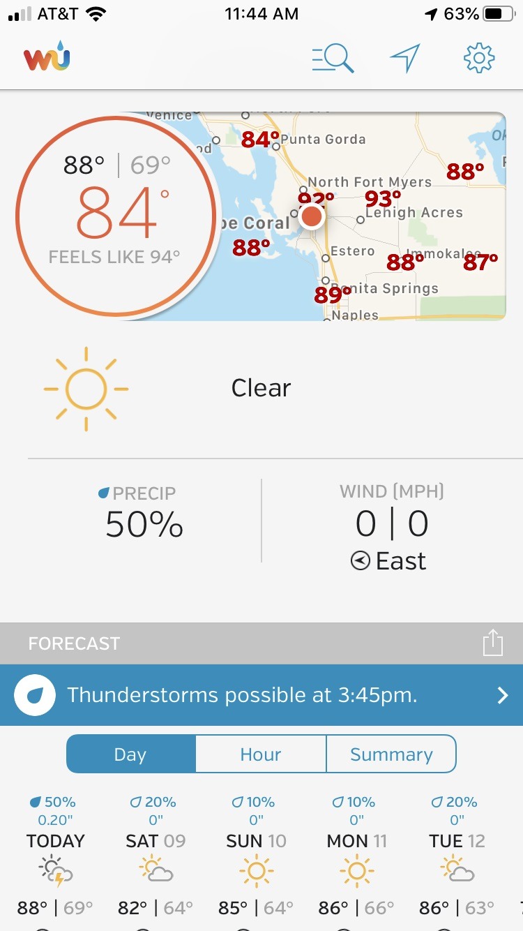
Aqua Map’s tide display Navionics Boating tide display
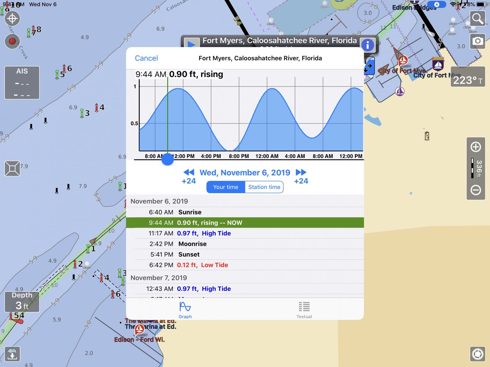
Highly responsive touch screen interfaces and flexibility to plan your travels away from the helm make mobile apps great planning tools. The inclusion of tide information, weather forecasts, and bridge and locks schedules make apps especially useful for planning.
Navionics
Navionics Boating is a full-function navigation app that has recently received quite a few major new features. It’s also the easiest of the three apps discussed to use. Think Google Maps easy! The core features that have made Navionics one of the leading navigation apps are their dock-to-dock auto-routing, community-sourced SonarCharts, easily downloaded daily chart updates, and a responsive, easy-to-use app. In the last year, Navionics has added support for Active Captain Community crowdsourced data and display of AIS data from an onboard AIS receiver.
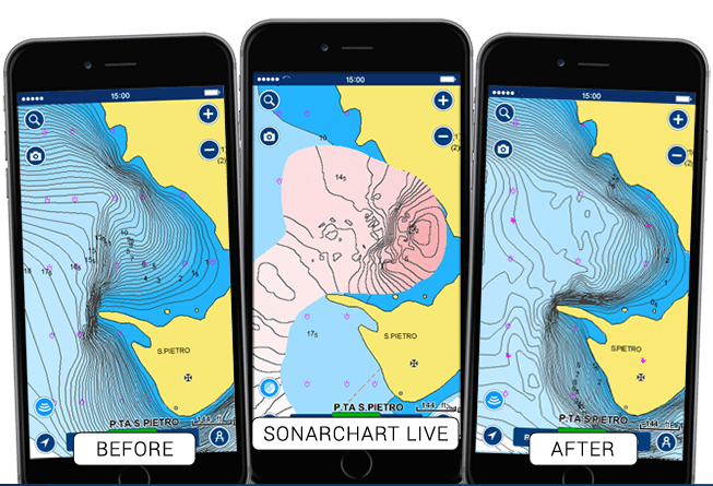
Navionics’ app also supports its SonarCharts functionality. SonarCharts Live records depth data from an onboard depth instrument and displays it in real-time on your chart within the app. That data is also recorded and shared with Navionics, who then processes the data and creates a SonarChart layer within their charts based on the data received from the many boaters using the Navionics app or an MFD capable of recording and uploading SonarChart data.
All mobile apps can be useful planning tools allowing you to plot your course for travels from the comfort of a couch. But, Navionics goes one better with Plotter Sync. If you’re using a B & G, Lowrance, Raymarine or Simrad MFD you can synchronize your routes between your MFD and the Navionics App by using the WiFi connection in your MFD. Navionics sells its app as a subscription with an annual U.S. subscription for $15 per year or U.S. and Canada subscription at $22 per year.
Aqua Map
Aqua Map is a newer entrant into the navigation apps marketplace but they’ve quickly built a capable app with an impressive set of features. Aqua Map supports several major features important to many boaters and has a few features entirely unique to them. Aqua Map displays both Waterway Guide and Active Captain Community crowdsourced points of interest to provide information on marinas, anchorages, hazards and navigational features. The app also has a highly capable anchor alarm that makes monitoring your boats’ position at anchor easy and accurate. Aqua Map is available in the iOS and Android app stores for $10 for U.S. charts with one year of updates or $25 for lifetime updates. Aqua Map with U.S. and Canadian charts is $15 per year or $40 for lifetime updates.
Aqua Map has added a compelling set of features they’re calling Aqua Map Master, available as a $10 per year add-on. Master includes the ability to display Army Corp of Engineers surveys overlayed onto your charts. Master also includes Route Explorer and the ability to display AIS and instrument data display. Aqua Map master’s capabilities show its greatest value when traveling in shallow waters, areas with hazards, and under bridges. Many of the features were developed for cruising the Intracoastal Waterway.
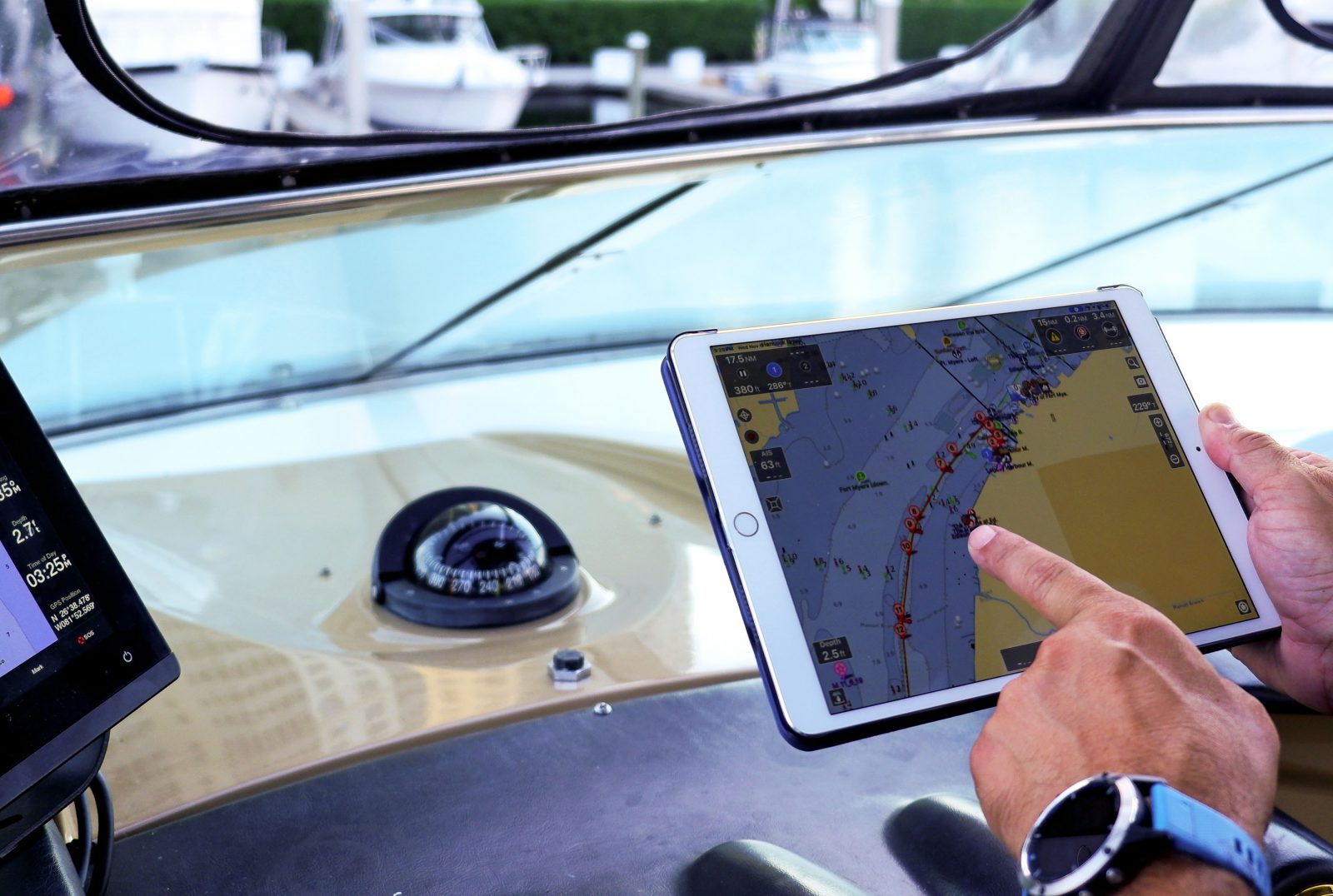
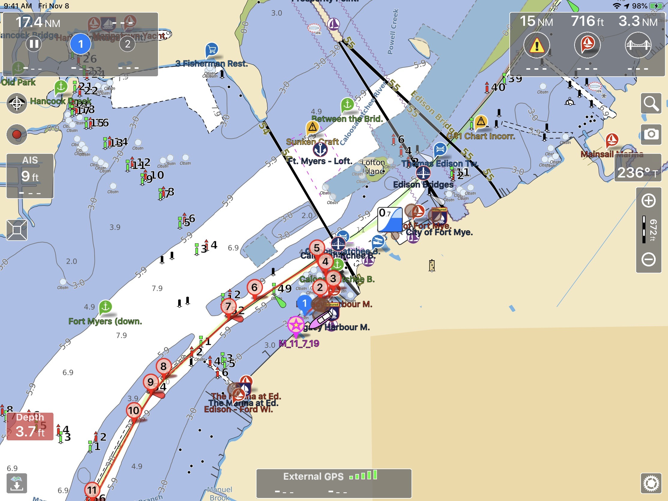
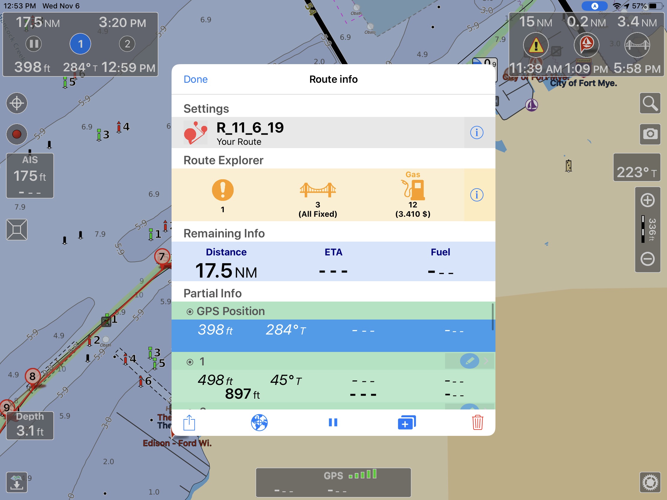
Route Explorer’s capabilities can be seen above with a sample route down the Caloosahatchee River. The Route Explorer section on the popup in the middle of the screen shows there’s one hazard on our route, three bridges (all fixed) and 12 potential stops for fuel with a minimum price of $3.41. Once underway the center box would be dismissed but we’d still have the top left and top right corner boxes. The top left is showing our progress along our route with distance and ETA to our destination. In the same box, distance, heading, and ETA to the next waypoint are shown across the bottom. The top right box is the Route Explorer box showing we’re 15 nautical miles (nm) from the next hazard, 0.2nm from the next marina and 3.4nm from the next bridge.

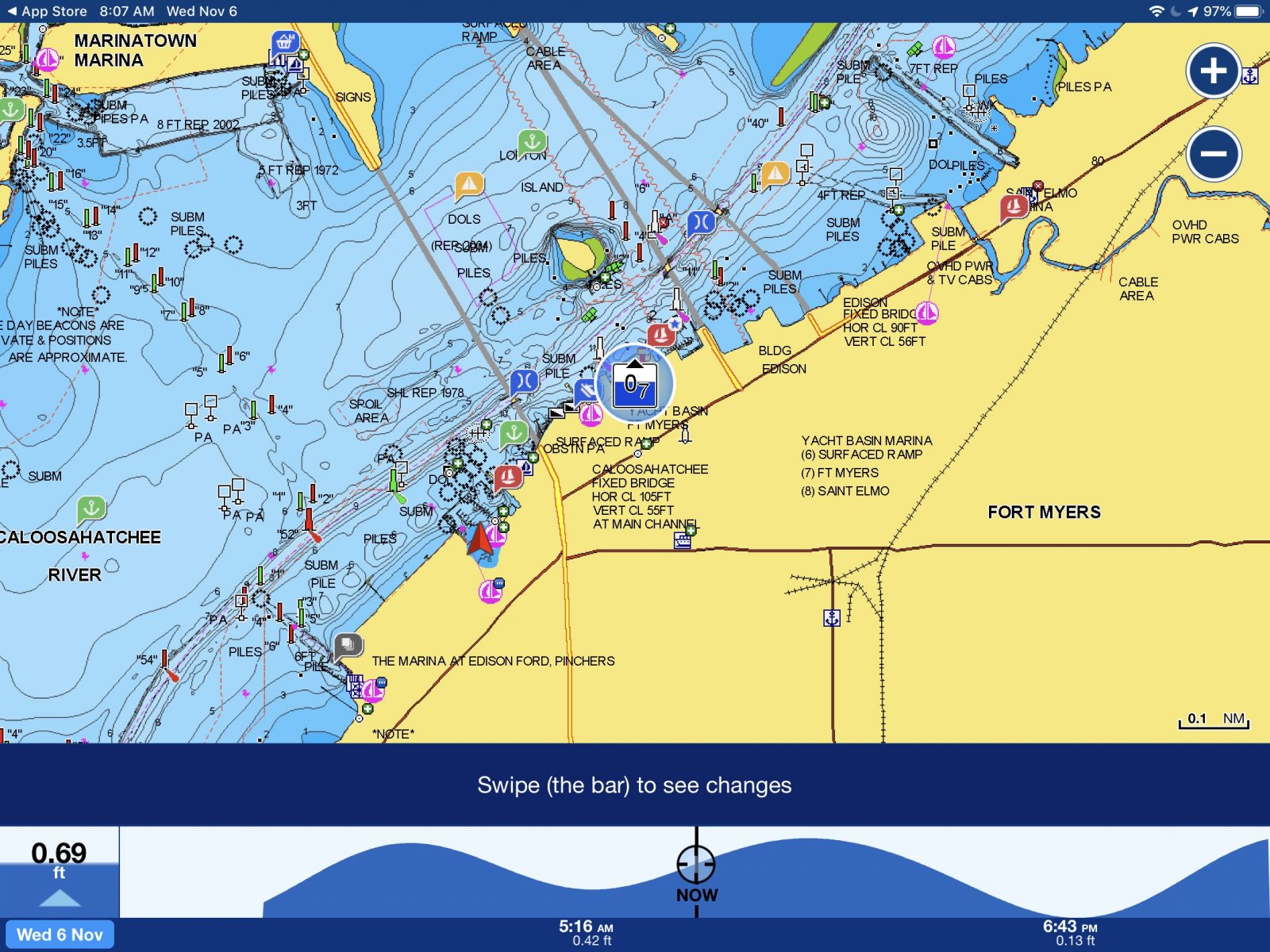
Aqua Map makes navigating in skinny water a little easier by overlaying the United States Army Corps of Engineers (ACOE) survey data over the chart display. The survey data gives good visual clarity to where the deepest water can be found in problem areas. The ACOE has made survey data available for many years but it’s only been available via district websites in PDF or Google Earth files. Aqua Map allows the surveys to be easily displayed and updates them using their chart update functionality.
iNavX
iNavX is one of the pioneers in providing full navigation functionality with a mobile app. iNavX has been offering mobile device marine navigation since 2008 and they’ve built a lot of functionality into the program but it comes with the steepest learning curve of all the apps. iNavX costs $5 with access to free NOAA charts. Additional charts are available within the chart store built into the app.
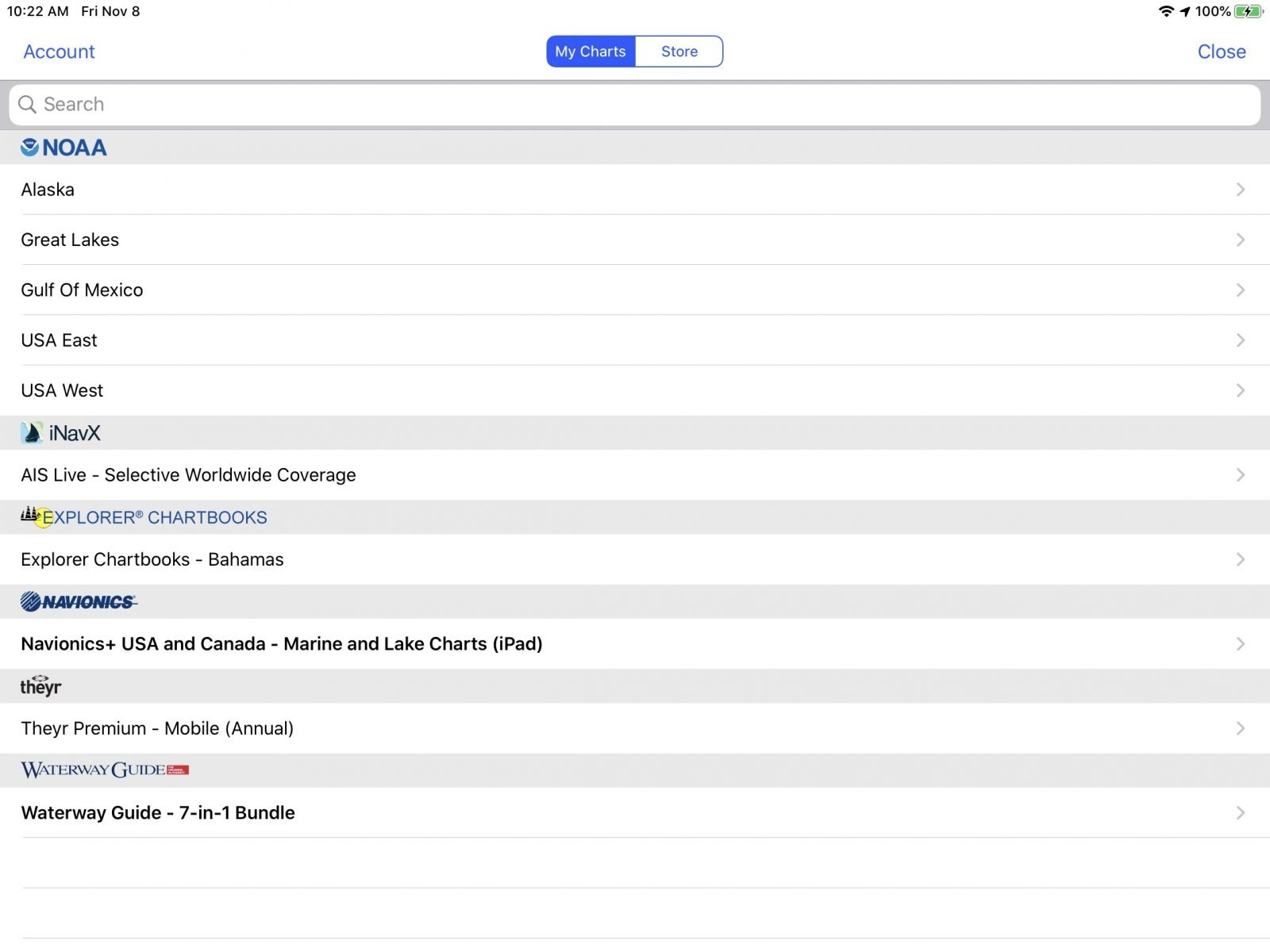
The app supports the broadest range of chart sources of any mobile app, including Navionics, NOAA, Canadian Hydrographic Service, Explorer Charts’ Bahamas Charts, Blue Lattitude’s Mexico charts, and Delius Klasing European charts. Plus, iNavX displays Theyr weather and Waterway Guide companion content as chart layers allowing you to display additional information on top of your chart.
Like Navionics and Aqua Map, if your boat is equipped with an AIS module and WiFi gateway, iNavX can display AIS and other information from your boat’s navigation system. But, unlike the other two packages, iNavX can still display AIS information even if you don’t have an AIS receiver or transceiver on your boat. Using their AIS Live service, iNavX uses a series of receiving stations to transmit AIS information to your mobile device via the internet. This data isn’t updated as quickly as the information coming directly from an onboard AIS receiver but can be a useful alternative if you don’t have AIS equipment on board.
Safety and support apps

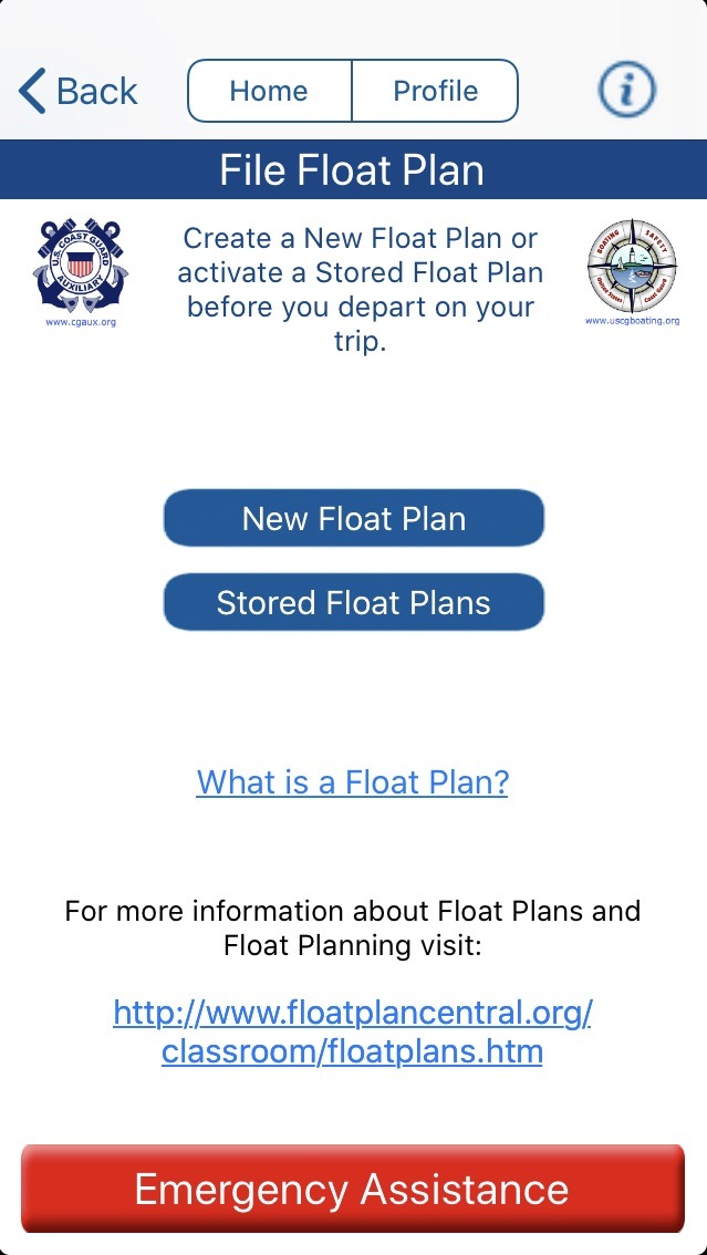
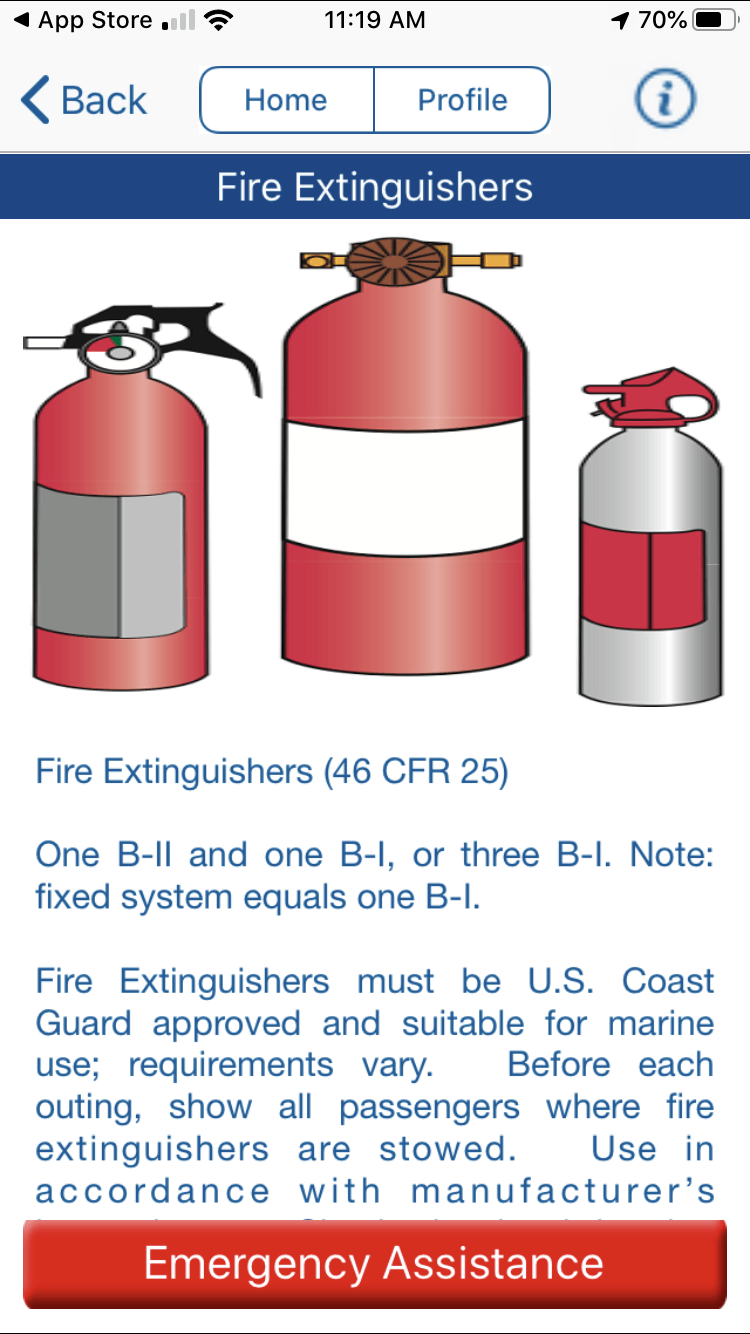
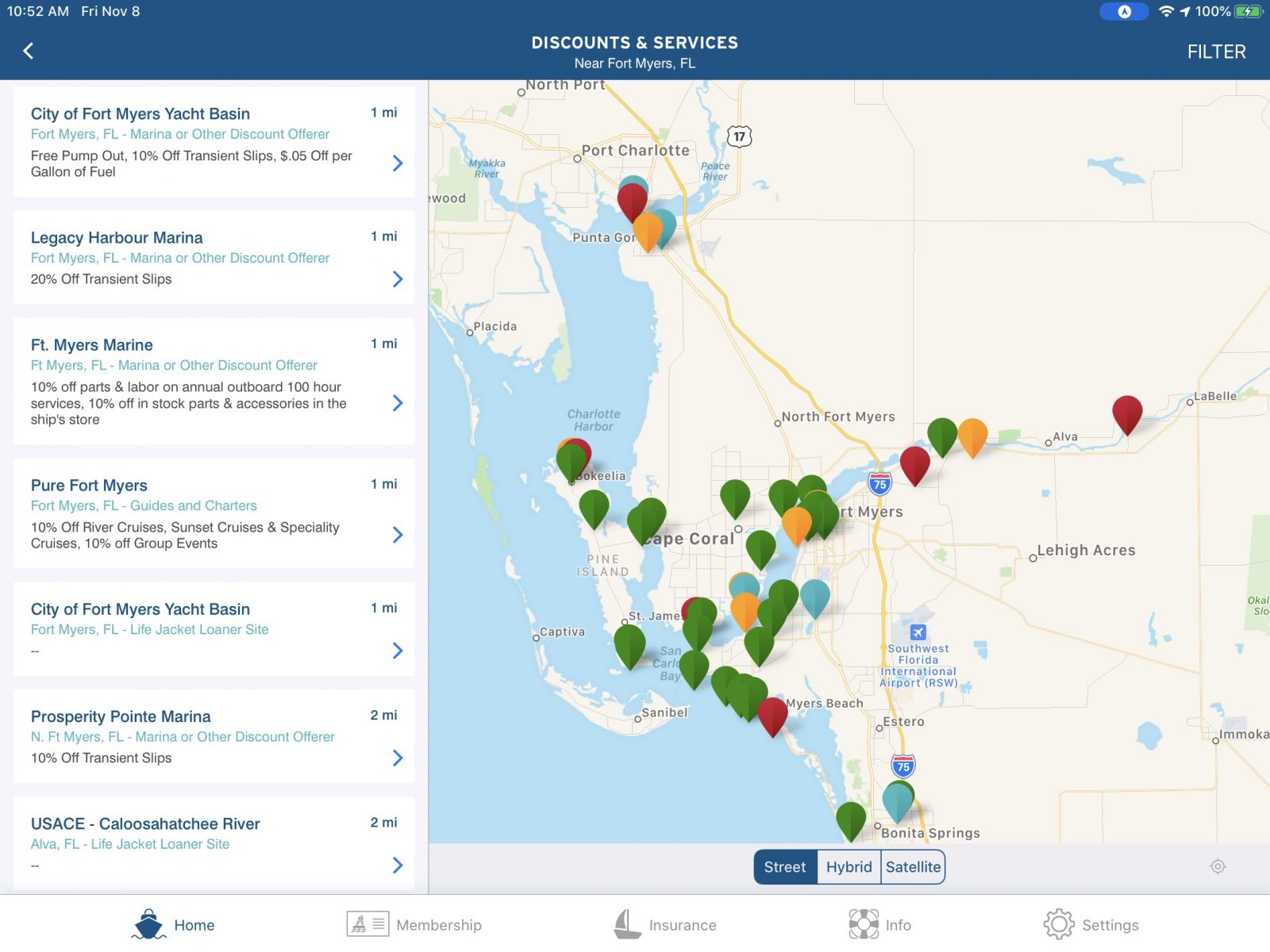
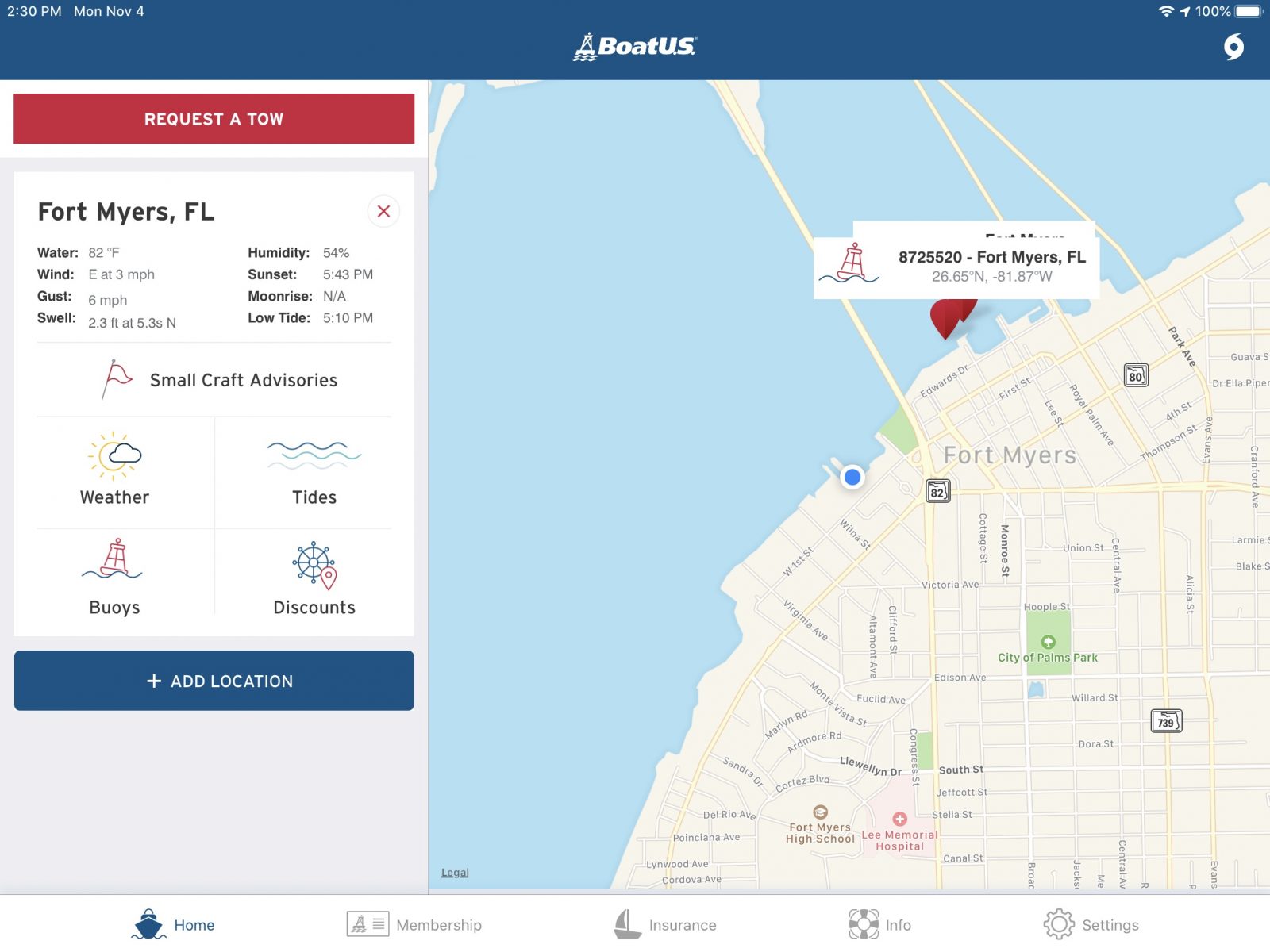
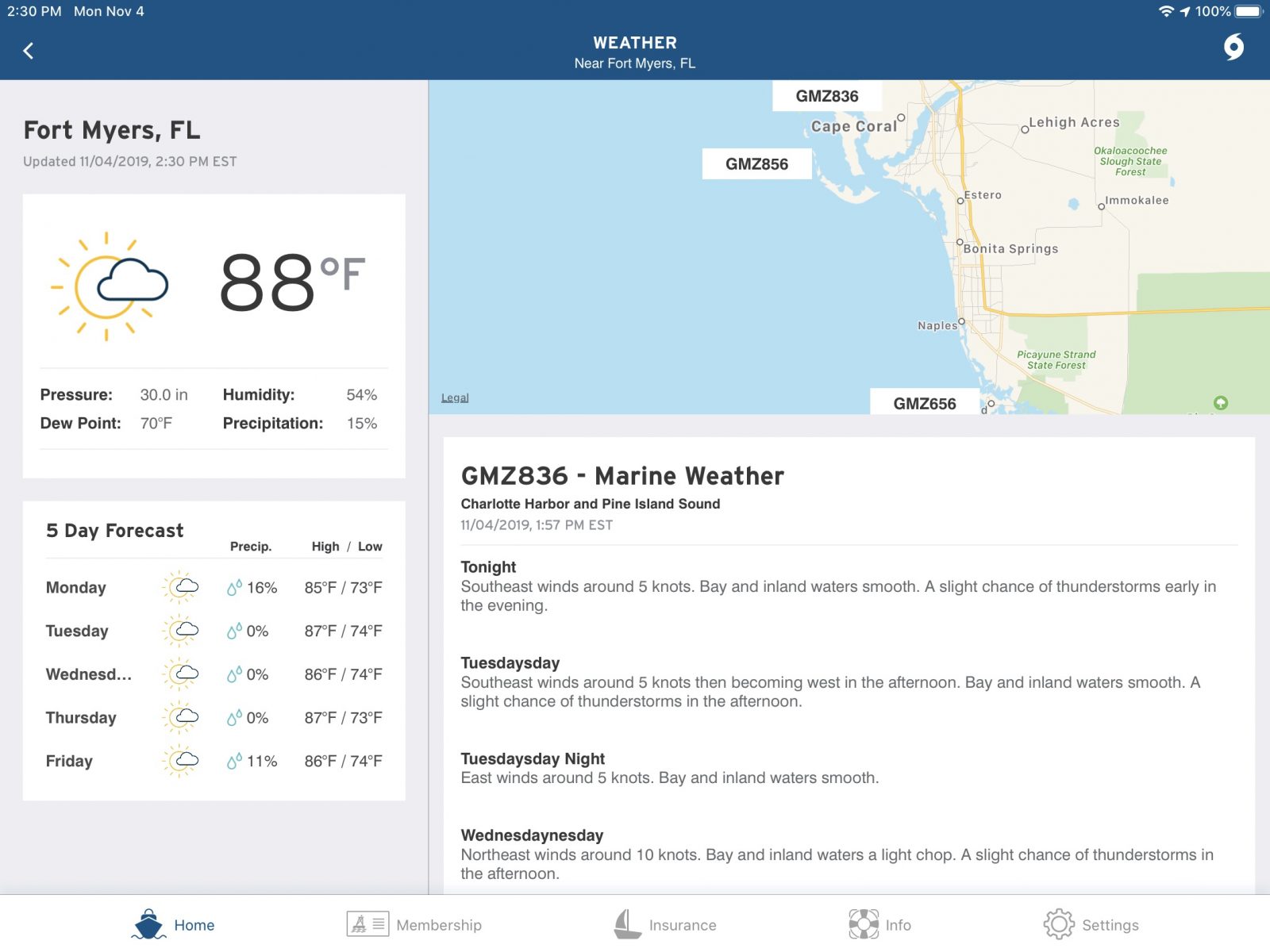
Boating apps aren’t limited to just navigation. The United States Coast Guard and Boat U.S. both have apps aimed at making boating safer and easier. The Boat U.S. app allows you to check the weather, look for discounts in your area, check your membership and insurance status, and even call for a tow. The Coast Guard’s app allows you to fill out a float plan and file it with friends and family. Additionally, the app provides a way to report hazards, pollution or suspicious activity directly to the Coast Guard. Plus, the Coast Guard app provides information on recommended and required safety equipment, access to the rules of the road, state boating regulations and a means to request a safety check from the Coast Guard Auxilliary.
Weather apps
NOAAWeather Radar Live Windy Weather Underground
One of humankind’s favorite past times is discussing (and complaining about) the weather. So, it’s no surprise there’s a nearly endless supply of weather applications out there. Depending on where you do your boating you might be in search of dedicated marine weather applications (coastal and offshore boaters) or you might be better suited to find a general-purpose land focused weather app (inland waters and rivers). The screenshots above are of NOAAWeather Radar Live, Windy and Weather Underground apps. These three serve as examples of the thousands of weather apps available.
Almost all weather information in the United States comes from the National Oceanic and Atmospheric Administration’s (NOAA) network of sensors. The main difference you will see among the weather applications is the forecasting model applied to the data NOAA collects and the way it’s displayed. If there’s a weather application you find easy to use and informative, you’re well served to stick with it.
One often-repeated piece of advice from weather experts is to never shop for a forecast you like. If you consult multiple sources of weather using multiple models you should be looking for agreement among those forecasts. If three forecasts suggest you may have poor cruising conditions but a fourth shows good weather you’re likely well served to discard the outlier and go with the consensus. Doing otherwise is a recipe for a lumpy, fatiguing day at the helm.
Final thoughts
The combination of these apps and a mobile device might not be full-fledged replacements for the dedicated and installed equipment onboard your boat. However, they can make your boating easier and more pleasant. They keep information at your fingertips, keep you updated when conditions change, and even summon help when you need it.
But, the apps I’ve listed above are the ones I’ve had the opportunity to use and like. These might not be the same apps you like the best. So, I’d love to hear from all of you about what you use and what works for you


I find TimeZero iBoat to be a wonderfully fast and elegant charting app. I especially like using it with NOAA raster charts overlaid with the same very high-resolution photo maps that are available in Nobeltec TZ PC and on Furuno TZ MFDs (and that “fuse” in some shallow water hazards).
iBoat also nicely supports worldwide C-Map vector charts and it can integrate well with onboard AIS/GPS/etc data over WiFi. Route sharing with the cloud and other TZ products has long been in the works and I’m hoping it will be complete next season.
https://mytimezero.com/tz-iboat
For me a key other component is the tablet and case. For my use the best I’ve found is a big 12″ iPad in a Lifeproof Nuud case. The newer iPads are much brighter and almost as daylight viewable as MFDs, and the Nuud case, whilst immersion proof, does not have a cover over the screen greatly improving sunlight view-ability.
A few apps I like:
iSailor – a good charting/nav package that integrates well with the boat’s instrument system by WiFi. Worldwide charting based on Transas data.
Tides Planner – tide prediction, with curves, and access to UKHO harmonic data and UKHO and SHOM (French) tidal stream atlas data. Very useful off the UK coast, but worldwide coverage.
Microsoft Remote Desktop works well to bring the Nav Station laptop running Expedition on deck.
WatchMate – used mainly as an anchor monitor with my Vesper XB8000.
NMEARemote – configurable display of NMEA wifi data, with extra support for Expedition.
iPolar – Basic polar prediction.
iRegatta – Some relatively sophisticated race orientated software with NMEA wifi data support.
I second Tom’s appreciation for the Vesper Watchmate app, which I’ve used it a lot for anchor drag monitoring and also for AIS collision avoidance. I think it’s particularly notable because it makes great use of an iPad while also protecting the user from the iPad’s weaknesses. What I mean are the audible alarms that you can set up on the iPad but which are completely independent of it because they are activated by the XB8000. Many times the alarm has been valuable to me even though the iPad was dead or doing something else.
Also, thank you Tom for the tip on Microsoft Remote Desktop. It’s not obvious that there’s a companion iOS app, plus it’s all free and has a pretty good reputation. It might be just the thing to give me a portable second screen for TimeZero PC (and other PC charting programs), which will be valuable because TX iBoat will not include the Furuno NXT radar and sonar I’ll have networked with TZ PC.
I like the Microsoft Remote Desktop tip for the same reasons Ben lists… Thanks Tom!
The apps I forgot are the weather ones:
Ventusky – free, great global visualisations.
Predictwind – subscription data but quite good information with their own models.
Squid – excellent Grib viewer with subscription access to some great models including the French Arome HD 1km resolution European wind model.
In truth I mainly use the predict wind and Squid data inside Expedition on the PC, rather than through the Apps when on board. I do use the apps in the run up to a trip to watch the forecasts.
I use INavX with a ShipModul WiFi multiplexer that gives me the ability to have it in my lap on my iPad when short handed. I can easily buy a six pack of iPads with what a standalone chart plotter costs. I can take the iPad home update it, make routes , upload, download routes and waypoints. I can see AIS in real-time
Navionics has the most detailed maps, but it comes with a price. No Magnetic coursing. It get you in trouble if you forget that. Awful for route unles you use autoroute. I choose to use INavX primarily, then switch to Navionics when coursing tight spots inshore . I’m against the 80$/yr they want for charts for INavX so I just use the Marine Boating App for their charts
Our crew have been using the ‘Watch Leader’ app this summer,
it streams data from any Navico product (B&G, Lowarance, Simrad) to any Apple device including the apple watch. Its amazingly simple to set up and intuitive to use. Definitely worthwhile for anyone who likes having all the instrument data on their Ipad or watch.
Thank you for the review Hugo! We are really pleased that you and your crew are enjoying and benefiting from using Watch Leader https://youtu.be/adLlBHPnuwU – All the best, The Team at Osprey
As we are cruising full with a family of five often in remote areas we rarely have internet access especially on passage. Our main weather app is Predictwind Offshore as it integrate well with the Iridium Go. As the areas we go to often lack reliable chart data we often use Ovital Maps as a way to use offline satellite imagery.
On our classic 1965 longkeel 30ft sailboat the cockpit under the sprayhood is quite small,
I tend to use small displays, a bunch of old iphones come in very handy.
4 x Iphones 4/4s/5s/6s in lifeproof fre housings on two suction mounts.
Usually its two phones under the sprayhood ( take just a second to unmount them and use it fully handheld ) and a third one down in the cabin @ nav station.
iNavX & NVcharts app with raster charts on it
( usually set to two different zoom ratios ),
IMHO the key feature when using such small displays is to be 100% identical with the papercharts I combine it with, I find this this combo to be fast and reliable and I don’t miss iPad size screens or MFD’s too much.
AISdata via Wifi from EasyTRX2S transponder.
Other apps with lots of usage:
Windfinder Pro
Weather Pro
Windy
Sea Weather ( german app to repeat official weather reports and Navtex reports and gale warnings )
EasyTRX app to handle the settings of the AIS transponder & CPA and anchor alarms.
2 x anemometer apps, Vaavud and Weather Flow.
I find the brightness of the old displays sufficient and ok to handle, but sure it would be nicer to have 1200nits with this size of displays, absolutely.
Temperature issues in bright sunlight I solve with simply switching the display off in between, both nav apps are ok with the speed picking up the signal after coming back on, could be faster but its ok to use.
What I’m really dreaming of is an update of the Furuno Wifi Radar ( or by Ray ) to solid state and maybe even with doppler function,
yes it would really cannibalize their sales of expensive MFD’s, but hey…find a heart for budget yachties, me and quite a few other peeps are quite reluctant to spend 4-6K on a radar setup.
( and I do miss space even for a 7″ MFD )…. just a few coding sessions away 🙂
HTH,
Jan
Berlin, Germany
Many of my friends have iNavX but I prefer SEAiq which also costs $5 for US waters (http://seaiq.com). It integrates with many chart sources, hooks up to WiFi-enabled local nav data (including AIS), and accesses remote a remote AIS database when in cell range. The electronic bearing lines and range rings have been very useful. I’m just now starting to use it to record NMEA data for off-line processing.
I’ve used the PredictWind/Iridium Go combo which worked pretty well – putting the antenna on a transom-mounted pole to keep it clear of the carbon fiber mainsail was a great idea from our installer. Tried and true saildocs (www.saildocs.com) still works for free weather grib download and has a decent set of models to choose from.
I use LuckGrib (https://luckgrib.com) to view the weather on Apple devices – it’s a bit more complete than any of the nav apps or Predict Wind.
Still looking for a tide app I like. Instead I usually go to NOAA’s site directly, though I’ll occasionally use SEAiq’s integration with NOAA’s model. You can find the tide in your area at https://tidesandcurrents.noaa.gov/
Thanks Lance. Sea1q seems like a very good product. I presently have INax and it doesn’t support NOAA ENC charts, doesn’t have chart quilting or great AIS presentation like Seaiq.
INavx does have good NMEA support for input and output.
TZ Timezero (MaxSea) on my iPad. Raster charts from the official national hydrographic offices. Cheap.
From Nova Scotia to Israel, from Tunisia to Scotland, this has been a major safety item for us.
When Navionics (which we also carry) failed to display that bridge clearance on the Guadalquivir, or misled on the Mar Menor, or plainly faked the bottom on Ithaca, or misplaced those rocks in Islay (Scotland), those paper-like TZ charts delivered,
Thanks, Xavier! This comment could not have been more timely, so I used it:
https://panbo.com/noaa-will-sunset-traditional-nautical-charts-sad-but-inevitable/
But TZ TimeZero for iPad does not offer their wonderful raster charts for Norway.
Weather4D does. So when we went there we got the whole set of official NHS paper-like charts from Weather4D, which is a nice French-made app, all in English of course, that provides routing, weather, charts, and instrument integration with the boat.
Weather4D has a bit of a learning curve, but once you have it properly set up, it is the most comprehensive iPad tool around, down to displaying its data on your Apple Watch.
Crew Manager – http://crew-mgr.com/
This application is great for managing everything around commitments of crew to racing events and having a web-site for my boat. See mine at Strider.crew-mgr.com
We have used ISailor on an older iPad for a few years. Recently added a second iPad and AIS thru WiFi from quark electronics. So far, install was super easy with absolutely no issue (and integrates with iSailor fine). This past summer while cruising around the Great Lakes, we had several days of leaving early in the morning in fog, in the dark, with numerous fishing boats and commercial traffic lanes around us. So we just purchased a furuno drs4w WiFi radar and and are anxious to abuse this new tech. This setup seems to be a good fit for a sailor on a tight budget, not sure if I’d use it on the ocean, it seems ok for the Great Lakes. One more thought, we have an HDMI interface cable plugged into an iPhone we use for Netflix to our tv, with this option, and the apps running on the iPad, and iPhone, it gives us a ton more ways to view and monitor while under way.
Do we have a useable (out of mobile signal range) way to use google earth overlay on a mapping program yet? Where I live the google earth image of a reef is often amazingly detailed compared to any chart. Any dowloadable google earth image set usable offline and integrated with navionics or similar would be wonderful!
We have been using OvitalMap for years. It kind of gives me the jillybillies because it is made by some Chinese guy, so I always make sure to shut it down after we finish using it. Plus, it is only installed in one of the three onboard iPads, just to be safe.
Anyway, here’s what it does: it automatically downloads marine GoogleMaps to your iPad. Islands, shoals, piers, it is all shown in there. As is your current position, constantly updated by GPS. It downloads the google map tiles at whatever zoom level you wish; if you wish to have maximum detail, you must zoom in… and then it automagically saves that level of detail.
The downloaded material is kept forever on your iPad, unless you assign it too small of a memory quota in its own preferences, in which case it will either start deleting old stuff or ask you to delete it yourself. We’ve never had to delete anything because I think I’ve given it up to 10GB.
Thanks Xavier, i did find that app but hoping by now it would be integrated in a MFD easy to see in the daylight as the ipad struggles…. Have heard the newer ones are brighter though.
With the advent of the departure of NOAA/US Govt raster charts and if you still wanted to consult those charts, what’s the best mobile app for viewing/using raster charts?
Has anyone seen an independent app that more-or-less replicates B&G’s SailSteer display? I have all new Raymarine instruments and all NMEA2000 info is transmitted out via the Vesper XB800’s wifi to my Ipad & iPhone. I much prefer B&G’s SailSteer display over Raymarine’s Sailing display, though. Any ideas?
Mike,
The safest way to keep digital U.S. raster charts for a decade or two would be to put them on a laptop and to be sure and either never update said laptop again or to be positively sure the updates won’t break your charting program before you install any such updates.
Unlike in the Mac/PC world, in the iPad world you can never be quite sure of what will happen to your data as time goes by. I have had non-marine apps which permanently ceased to work after an iPad update, and have had paid-for apps that will not download to new iPads because the original seller no longer makes them available.
Having said this, my experience with raster charts on iPad is as follows:
(1) My Canada raster charts I bought in 2014 still re-download on MaxSea TZ iBoat now in 2020 and are still available for re-download on any new iPads I purchase as long as I keep using my same Apple iTunes/App Store account, even though MaxSea completely replaced the old app on which I bought them, which used to be MaxSea TimeZero.
(2) My USA raster charts I bought in 2014 still load on (and fully up-date to the current NOAA version!) on iNavX for iPad, even though I have not had any sort of update to my iNavX account (if I ever had one) since 2014.
(3) On TimeZero TZ iBoat you purchase a “subscription” which you can cancel before renewal, but MaxSea will let you keep and re-download the old charts you bought even under an expired subscription, “forever”. But remember “forever” is not forever.
(4) For navigational research, iNavX is superior because it literally downloads individual NOAA charts as issued. So you can look at all the annotations, margins, disclosures, etc.
(5) For actual navigation and day to day use, MaxSea TimeZero TZ iBoat is far superior because it quilts or tiles the individual charts to automagically make one giant chart that can even be worldwide. In this sense it works like a vector chart: infinite zoom from planetary view to maximum zoom, seamlessly. iNavX requires you to know “in which chart or chart inset you are” and will display your current position only if you are in the correct one. iNavX will happily let you sail out of the currently open chart, like in a real paper chart, and you can only have one open.
(6) MaxSea TimeZero TZ iBoat offers almost worldwide charts, and its raster charts are strictly from national hydrographic bodies, such as NOAA. So you can sail from Portugal to Israel, for example, and MaxSea Time Zero will always seamlessly display the correct charts for Portugal, Spain, France, Italy, Greece, etc., always at whatever zoom level you wish, up to maximum available from the issuer.