
Getting ready for Class B, does your AIS plotter do DR?
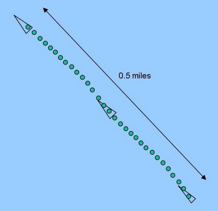
This diagram—borrowed from Dr. Andy Norris’s valuable AIS/06 conference presentation—illustrates various possible target presentations for a vessel doing 30 knots over a one minute time period. The green dots roughly represent both radar paints and Class A AIS messages received. (A normal 24 rpm radar would, of course, hit a good target twenty-four times in a minute; a Class A transponder going this speed sends out dynamic data every two seconds, or 30 times per minute.) But the triangular icons indicate what a smaller vessel (possibly a poor radar target) carrying Class B AIS might look like, given B’s maximum dynamic data speed of 30 seconds. Obviously the target could move a quarter mile between plots, making like a mexican jumping bean if your plotter/ECS is zoomed in very far.
Now there is an obvious, though processor intensive, way to smooth over Class B’s relatively slow data rate, which is for your plotter or ECS to calculate DR positions for each target between actual AIS fixes. I know I’ve been shown at least one PC-based product that already does this, but I can’t remember which one, and I don’t know if any plotters do DR (in an all-Class-A world it doesn’t matter as much). So please help me—either via comments, or e-mail—build a list of the AIS viewers that do or do not DR targets.
PS 12/7: Well, this DR idea turns out to be much more controversial than I realized. Apparently only Transas, which only seems to sell ECDIS these days, currently does DR calculations on AIS targets, and some developers have serious reservations about adding this ability to their own AIS target plotters:
“My opinion is that a DR feature in between AIS fixes presents some VERY SCARY Safety Concerns. I have heard that this issue has also been raised in the IEC ECS meetings. For example, what happens if the AIS Target you are tracking changes course after an update is received and then an extended period of time elapses before another update to the to the new ship’s course and speed are received??? The vessel may have made a course change which was not received by you and you may choose to make a critical navigation decision based on incorrect DR Position information.”
Others feel that, “The DR position is likely to be closer to where the boat actually is than the last actual position which is crucial for collision avoidance. You avoid a collision by anticipating where a boat will be, not where it was 30 seconds ago.” There may be a graphic solution, say changing the color of an AIS target’s “bread crumb” track to indicate fixed and DR positions. I will definitely collect more info and opinions, and share them here.


Is anyone else having trouble getting into Comments using your TypeKey ID? If so please e-mail me using the Contact link on right side of main page. Thanks.
Let’s see… Does this work?
I think MacENC/GPSNavX already do this.These apps plot a velocity vector generated from received AIS transmissions-it is a line drawn from an AIS equipped vessel’s reported position out to where it will be in X minutes, X being set in preferences. I could see somehow graphically altering said line over it’s length to illustrate it’s degrading accuracy over time, an essential modification of the DR concept to make it fit in with an otherwise real-time screen (well, almost real-time..). This is only a psuedo DR, but it would indicate graphically that the projected course/position’s confidence level decreases as we move thru the 30 seconds between transmissions. Now, I think an equally important question is how the existing Class A equipment out there will deal with this “30 second blind spot”!