
Em-Trak I100 Identifier, will AIS “be a victim of its own popularity”?
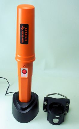
Though it looks like a commercial-grade AIS SART meant only for emergencies, the Em-Trak I100 Identifier is actually a special purpose Class B AIS transponder “suitable for even the smallest vessel.” It’s completely self-contained, with GPS and VHF antennas and a Lithium-Ion battery all packed inside that orange 14-inch tall waterproof casing. Once charged ashore in that AC cradle, you just twist lock the Identifier into the special pole bracket at right and it will automatically turn itself on and transmit standard Class B boat id and position messages for about five days. I haven’t actually tested the Em-Trak I100 in a kayak, but it certainly seems up to the challenge…
The Identifier also seems well suited for tracking tenders — and even “personal watercraft” — but if you download the brochure, you’ll see that it also seems designed for non-voluntary use. I say that because the I100 “has a number of built in passive and proactive security features to protect the unit from tampering and unauthorized transfer between vessels.” So if, say, an authority like the USCG wanted to monitor every boat moving through Miami Harbor, couldn’t they carry racks of these on their patrol boats and make any vessel that didn’t have its own AIS borrow a “Miami Visitor #xx” Identifier while in the area?
Now please don’t freak out, friends! While the Department of Homeland Security is definitely concerned about “soft targets” in places like the Port of Miami, it has shown no inclination to mandate AIS on recreational boats (despite the fears). I may finally have some news this week on the DHS plan to encourage voluntary vessel identification, but I assure that it’s not loaner racks of Em-Trak Identifiers. However, there are countries where AIS is already mandated on almost every vessel, and that makes me wonder about the old worry that too much of it would ruin its use in collision avoidance…
More specifically, I recently got a note from a writer friend who just used an AIS receiver in the Bahamas and noticed that numerous cruising boats have installed Class B transponders. “When adoption of B transceivers becomes more prevalent,” he worries, “displays will become too cluttered (like chatter on Channel 16 before cellphones), forcing people to disable this feature (like turning off the VHF because of the merciless chatter). I wonder if AIS will be a victim of its own popularity.”
My answer went like this: “I don’t hear people worrying about the clutter of too many Class B’s like they used to, so you’re a little late to that party. If there really is a problem, the solution is better target display software. A display can only show the targets that are moving, for instance, or only those that are within some CPA/TCPA thresholds. Others can be shown as simple dots or not at all (though they’re still being tracked). Turning off AIS reception altogether will be a dumb ass move and probably illegal.”
But he’s insistent: “I’m not late in the sense that mass adoption of Class B has not taken place yet. When it does, it will be a problem. The question is what happens when 70% of the rec boats are all simultaneously squawking out AIS on a Sunday afternoon on Biscayne Bay. I suspect the debate will flare yet again.”
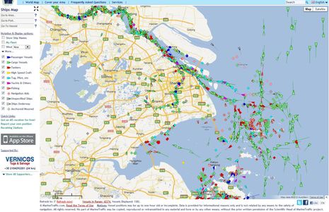
Let’s discuss! I’ll bet that a lot of readers have used AIS in places where the targets are much denser than the Bahamas or Maine, so let’s hear what it’s like. Afterall, the U.S. was late to approve Class B transponders and the authorities have not been aggressive about mandating AIS use on commercial vessels (where are those new mandates, by the way?). I think that widespread adoption of Class A and B AIS has taken place in some Asian nations, and maybe elsewhere. For instance, a peek at Shanghai on MarineTraffic showed 1,382 transponders in action, and almost half of those were underway (the count changes when you deselect categories). I believe that a lot of those boats are using AIS to avoid bumping into eachother, but what do their plotting screens look like? Has anyone been in traffic like this? Was it manageable? If not, would more intelligent plotting software solve the problem? Your thoughts please.
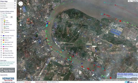
PS: While the Shanghai screen above is the sort of thing that makes folks worry about AIS clutter, it’s zoomed to a scale that’s not realistic for navigation. The screen below is what I found homing into a particularly busy spot. There are still 112 AIS targets in those few square miles but even just MarineTraffic’s ability to somewhat minimize moored targets and give active ones a six minute predicted course line make it reasonably readable, I think. Note too that I used the photo map which shows actual vessels (at the time of the photo), plus I checked the sizes of targets, and it seems fair to say that almost every vessel over about 40 feet is “squawking out AIS.” For this area, MarineTraffic does not seem to indicate if the transponder is a Class B, but I suspect at least some are. Anyone know more?


Since class B has low output power and low report rate it shouldn’t too much overload VHF channel. As for cluttering of the screen – yes there should be special actions to provide clear picture in the software.
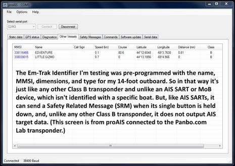
And i believe AIS SART should use not only the safety related message but special range of MMSIs as well.
Mitko, AIS SARTs and MoB devices do use special ranges of MMSI numbers, starting with 970 and 972. More info here:
https://panbo.com/archives/2012/06/ais_mob_devices_were_in_the_learning_phase.html
Incidentally, I’m not sure that the Em-Trak I100 Identifier is for sale yet.
Every time someone starts the AIS target overload rant a wide area sample of concentrated returns is shown. It always looks intimidating but if the chart or display were zoomed to a range you’d use to navigate, that blob of AIS returns would be quite manageable. Probably worse on a small dedicated AIS display but I don’t think it’s an issue with AIS info on a nav display.
In a canal transit last year, approaching Colon on the Atlantic end the AIS returns from ships waiting to go through were overwhelming but only from a distance. Once close enough to be doing something other than worrying about it and at a normal chart range it just wasn’t a problem and the AIS was invaluable.
Jon
Kees had a blog article about poor AIS screen display when there are many targets.
Showing AIS targets: Can you have too many?
http://yachtelectronics.blogspot.ca/2012/03/showing-ais-targets-can-you-have-too.html
Clearly some displays need work on their AIS presentation. I would like to see how all the different chartplotters handle the clutter problem.
I think the problem is inappropriate AIS symbol size when the chart scale is zoomed out. Distant vessels could be filtered out as long as that is just an option. Filtering stationary ones is not a good idea (rocks are stationary too and we don’t want them filtered).
Let’s back up a moment: why would I _not_ want to know about something that might hit me? How much pain can I stand to keep that information available?
My experience in Miami, Charleston, Norfolk and New York has been this: When my plotter is zoomed to a range appropriate for my vessel speed in that particular area, there was not a single vessel displayed that I did not want to know about.
I _would_ like a way to display anchored vessels with a smaller symbol, just as I would like to see dangerous CPAs receive more visual emphasis.
Besides; if you’re late to a party, it’s not much use trying to start your own.
I want to know about everything that could hit me and also that I could hit, vessels and rocks. The AIS symbols were designed for stand-alone AIS displays (IIRC). The problem comes when they are used on top of the chart display on chart plotters; they add information, but they also hide the navigational information on the chart. It’s all a question of balance, how to present all the important information so that it is most useful, and what is useful differs at different chart scales.
I agree with @norse that more work should be done to optimize the user experience as we add more and more data layers to vector charts. That said, how is turning off AIS because it is “too cluttered” (when zoomed for proper navigation) any different than turning off your radar because it’s showing “too many orange blobs”?
We see many 40 to 50 footers with AIS transmitters here in the Caribbean. We have found that sometimes we don’t see them until the are a couple of miles away, and have already spotted them visually. The class A guys normally show up before we see them.
Alas, we only have receive at this point. We’ve also found some who could easily afford one, not wish to advertise…..I’m not in that camp generally, but I would want to turn it off on special occasions like our upcoming pass near Venezuela.
We installed, and then removed an AIS receiver. The installation was less than satisfactory for two reasons. First, we connected it to a Standard Horizon GX2000. The screen size is just too small to display much data. In order to remove a jumble of clutter, we had to zoom in to the point that by the time a vessel appeared on the screen, it was well within visual range.
The second problem was the false alarms from stopped vessels. Nearly every marina that we passed on the ICW had at least one vessel transmitting an AIS signal while tied to the dock. The AIS that we had did not allow us to filter out zero speed vessels. We eventually turned the alarms off.
But the experience taught us that AIS could potentially be a useful tool, but only if we can filter out stopped vessels, and only if it is connected to a display big enough to show meaningfull data.
As far as Big Brother watching–well that is another issue. There are places in the world that I would not want to make myself too conspicuous, read Pirates, both the kind that work for a government, and freelancers.
My experience has been like Sandy’s, even in especially busy areas such as approaching the Strait of Gibraltar: I want to know about every underway vessel with AIS that’s nearby.
I’ve found that in busy ports like Fort Lauderdale, where there are dozens of AIS targets sitting at the docks, it’s helpful to filter out those that are not underway. I do that using my Nobeltec navigation software.
–Milt Baker, Nordhavn 47 Bluewater
From the perspective of an MFD (where I want to see rocks and lots of other stuff, not just AIS targets)I agree with norse as well as the statement Ben made, especially Ben wrote “If there really is a problem, the solution is better target display software”.
I would add (no matter there is a real problem of high density targets) that better alarming algorithms would contribute as well, algorithms that can discriminate when a low CPA/TCPA is an actual threat vs noise (e.g. like in a navigable channel filled with targets passing each other)
Tiny dots, that would be a great feature. And if visibility is good I would just take this optional all the time, probably including dots for stationary boats. It then makes it easier to see all the other items on the chart, especially useful coming into a harbor.
Even better, take the related radar return that matches an AIS target and merge them together as dot. The only radar returns should be objects without AIS or coast.
Back to better alarming algorithms. Both audible and visual alarms need to be much smarter, or MFD users we will just turn them off.
#1 Alarm algorithms should take some input from the user such as are you a sailboat currently sailing Y/N, what are current visibility conditions ?, do you have a look out right now, or are the normal blind spots in your boat (e.g. sails, etc,) need to be alarmed more than others (MFD would be pre-configured with a list of angular blind spots for the helm station) then adding in automatically based on wind direction angular areas where the sail blankets visibility based on point of sail. Maybe an option to choose who is at the wheel, Owner / Good Guest / Clueless Guest.
#2 Algorithm should recognize that the MFD manual inputs are being used and/or if the boat is actively being steered. If the user is interacting with the MFD and/or actively steering the boat, the alarms should be dramatically relaxed unless a target is in a blind spot. On the other side, if the boats on autopilot a long while the algorithm should be like my miniature schnauzer, very quick to alarm.
#3 Either manually (choose harbor mode for example) or automatically switch between modes such as open ocean, coastal, harbor, and follow the channel.
#4 Take all of the above into consideration before putting out an audio or visual alarm. Most extreme example is CPA=0 meters TCPA > 10 seconds, good visibility, no autopilot, “follow the channel” density of boats = no alarm.
#5 In doing the above, calculate some kind of volume level of threat from mild to extreme. Let’s call this a “level of threat of collision” (LOTOC) for the rest of the comment.
#6 Just like the idea of AIS contacts being presented (or not presented) based on LOTOC (e.g. target not moving, far away, etc.), do the same for alarms. Rather than big distracting alarm box or noise, how about on the MFD show the user a bar graph, coloring of a boat or sector, or other visual indication of increasing LOTOC.
#7 Same with the audio alarm, make it variable based on LOTOC. Maybe a clicking sound like an x-ray Geiger counter that clicks more rapidly as LOTOC increases. Ability to silence is useful, but do away with the dopey box in the middle of my display asking to “acknowledge alarm” (e.g. Classic E-80) that prevents me from using my chart plotter until I acknowledge.
And … I better stop here, and end on this thought. Whatever the next evolution in alarming solutions is, it would be great if the necessary information could go to smart phones so many people, like Kees, could experiment with many possibilities, and there be feedback that goes to the MFD (a PGN for LOTOC of each AIS target?) so the smartphone can feed alarms back to the MFD’s and augment the display to the user on a moving chart, rather than a sunlight unreadable smartphone.
It’s ALL about the software when it comes to presentation.
Give the user flexibility in what he wants to see. The busier the area, the less you want to see (ie, collision courses only, or ony stuff within a mile or 2)
As far as using up too much airwaves, I doubt that would happen. The bandwidth needed for this data is VERY small. From my quick research it is only about 50 bytes per message.
Check out the English channel or the port of Rotterdam/Hoek van Holland Maas approach. Very busy w commercial stuff.
Ben,
Great thread. Good idea getting it going. It gives me some perspective on the column I’m now writing about Vesper for PassageMaker magazine.
I just want to address Sandy, whose posts I’ve been following for quite some time. Respectfully, just because a topic has been discussed in an online forum in the past does not mean that it has been “adjudicated.” I see this in other forums, a tendency by “the initiated” to dismiss new voices just because a particular issue has been discussed in the past.
Also,Sandy, your experience in Norfolk and New York etc. happens to be the same as mine and equally irrelevant. As I said before, I am not concerned about today. AIS today is, in general, great. That is why the adoption rate is accelerating among recreational boaters. I am concerned about the future, which is why comments such as those of Mr.Corcoran are dead on the mark and very useful, despite his attendance at said redundant party.
I crossed the English Channel last month from Calais to Dover, in a very dense fog, and I can say that the AIS was absolutely invaluable. With the radar overlay on my chartplotter I was able to do what was essentially an “instrument” crossing. There were a LOT of large ships coming up and down the channel, a substantial number of ferries crossing with me, fishing boats, and even about a dozen private vessels making the same trip.
I did not think that there was any AIS overload during the entire crossing. The VTS people like to be able to see and understand the intentions of the small vessels, and the ships do not hesitate to call to talk about who should go first.
I share the same concerns about govt abuse, but bad guys only have to turn their units off/cut power/cover them with aluminum foil to go into stealth mode. I have talked to a number of Europeans who will not visit the US because of the requirement to check into/out of every port they visit there. Maybe with AIS they won’t have to do this. I don’t have to do it here in Europe, and the customs people have told us that they like it because they can see potential “targets” more easily.
Peter,
I know exactly what you mean. I’ve crossed Dover-calais in clear daylight and that was stressful enough. The big ships weren’t so bad, but the ferries were a big problem. They are FAST and there is TONS of them. Insane. Getting into Calais with 25 knots of wind was no fun. Doing this in the fog is impossible without Radar/AIS.
I doubt government would abuse it. I think a mandate would help us all.
Back in 2007 I commented that Class B signals were going to provide TMI: http://BitterEndBlog.com/?p=641
Geez, Richard, that old entry was pretty confused:
“The new Class B AIS, while not as robust as the Class A for the big guys, has potential when used by an individual with training. The Coast Guard (Homeland Security) would like to see all recreational vessels have AIS capability. The thought is that another USS Cole incident could possibly be avoided on our home shores. AIS picked up steam after 9-11, and was adopted by the IMO as a recognition system for vessels in transit.”
The fact is that it was the year 2000 when the IMO “adopted a new requirement (as part of a revised new chapter V) for all ships to carry automatic identification systems (AISs) capable of providing information about the ship to other ships and to coastal authorities automatically.” ( http://goo.gl/a4OtZ ) Class B was conceived of as part of the original AIS plan and so neither initiative had anything to do with what happened on 9/11/2001. And while DHS did become interested in tracking recreational boats after 9/11 they never said they wanted to do it using AIS. And obviously they haven’t made a single move in that direction during the five years since you wrote that. Maybe a correction is in order?
I also dispute your notion that Class B AIS requires operator training. In fact, if you check out the I100 Identifier product highlighted in this entry, you’ll see that a transponder doesn’t necessarily have any user interface whatsoever. Of course most users do want to see AIS targets, either with a plain receiver or the one built into their transponder, but I’ve yet to hear of an “AIS assisted collision” (anyone?) like I have heard of radar-assisted collisions.
I agree with you that operators must be careful about keeping their head out of the boat but they can make that mistake with paper and pencil navigation just as easily as with electronics, I think. And I don’t believe that the overall TMI problem is as great as you seem to. Could that be because you tend to meet boaters in distress?
Singapore requires AIS on every vessel including yachts in Singaporean waters.
EU has new rules coming into effect that while not directed at yachts will negatively effect them.
http://www.noonsite.com/Members/val/R2012-04-02-1
http://www.noonsite.com/Members/val/R2009-03-20-1
Anyone who has been to Singapore knows what what a stifling and undemocratic place it is.
http://snapshots.travelvice.com/download/20693-4/DSCN8341.JPG
Whether your sanguine or not its coming to your country and its a shame.
We were recently in San Francisco harbor on a Saturday. AIS was not only helpful in identifying the ferrys and commercial traffic, but also Saint Francis YC race committee mark boats and judge boats had AIS transmistters onboard. Many of these vessels were only 18 foot long. It made it much easier anticipating what the racing yachts were going to do and choosing a safer course. I can also see great advantages for the race committee. We see many advantages to using two chart plotters, one with AIS, the other without AIS data.
Any word when the Em-Trak I100 will be available here in the U.S. ?