
Camden NOAA chart changes, the questions
So I’ve done more research into the various small issues I’ve noticed regarding recent NOAA chart changes to Camden Harbor (discussed most recently here). Let me emphasize small, and also my appreciation of NOAA as an agency with vast tasks and limited resources. The intent of charting the Outer Harbor channel buoys maintained by the town, and updating dock details in the crowded Inner Harbor, is excellent; nearly every day I’m around the harbor I hear visiting boats getting guidance about these matters via VHF, and the verbal guidance often doesn’t work well. But the chart update issues certainly bring up questions about data sourcing and NOAA’s quality control system, as well as others regarding intentional and unintentional chart presentation details. And they probably apply to the official charts all around the country…
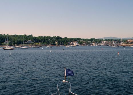
If you click on the top picture, you’ll see what the channel looks like now, as seen from its outer end. It’s darn straightforward (aside from the fact that you can’t see where it starts when entering the harbor), and it’s looked generally like that for decades, though I think the Harbor Master may have adjusted the buoy lines slightly during some spring settings, seeking maximum width without any of the moored boats swinging into the channel. (He has the buoy and mooring locations all databased on a plotter and in a PC charting program.)
At any rate, I ran close along both buoy lines last week, marking the red and green balls as best I could (though not realizing that some of the no wake buoys are also charted as cans and nuns), and you can see the results below. I was surprised to find that the newly charted red buoys largely reflect reality and that the channel is indeed offset from the Special Anchorage Areas boundary lines that are supposed to define it. I hadn’t noticed that before and don’t yet understand it, as the Harbor Master created those lines himself during the long process of having the Areas officially approved.
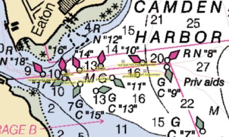
But one thing I’m 99.9% certain of is that the green channel buoys have always been in a line and that line has never been near the charted location of #13, which is way into a field of granite mooring stones that rarely get moved. Or even #15. Apparently the party who charted these so-called “private aids” was either the U.S. Coast Guard or members of the USCG Auxiliary or Power Squadron working through something called the
Cooperative Chart Updating program (mentioned at the bottom of this NOAA page), and I understand that plotting mistakes get made. What I don’t understand is how this channel buoyage got through a quality control process. Have you ever seen a channel buoyed like this, especially one running through an area of consistent depths and no hazards? Shouldn’t a cartographer have questioned it?
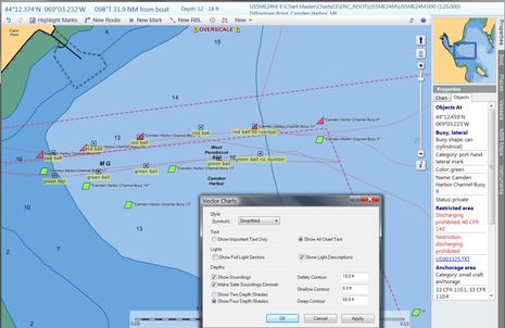 I also don’t understand what happened to the “Priv aids” label prominently displayed on the new paper chart (and RNC below) when the new ENC was created. NOAA says it has no control over how ENCs are displayed, which is true, and that’s why I put Coastal Explorer in full detail mode above, and opened the ‘options’ box indicating that “Show All Chart Text” is enabled. So is CE somehow ignoring a “Priv aids” label or did it not become part of the ENC database? If not, why not? (Note that if you dig into the ENC buoy properties you’ll see “Status:private” info, but it takes some digging.)
I’ve also learned that NOAA’s policy is that “All aids, regardless if private or federal maintained, are depicted using the US/internationally recognized symbology” but I question that too. It seems to me that older charts used to graphically differentiate official buoys from private ones, which is generally true to reality. The reality that all those numbered cans and nuns above are in fact unnumbered round balls or even “no wake” pylons seems like a good example of why such a “uniformity” policy can be confusing. And why the “Priv aids” label is a valuable tip off to a fog bound navigator. Now to the Inner Harbor…
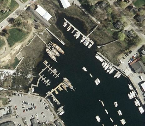
 An interesting thing about the first 1:20,000 scale Camden ENC is that all those docks at the head of the harbor are not copied from the equivalent paper/RNC, but instead represent a fresh survey by someone. And for the most part the Public Landing at lower left is very faithfully represented. Gizmo really was alongside that particular drop off float when I took that “New Mark”. But the pier I clicked on in CE does not exist (and never did exist), which is easily seen in many available satellite photos…
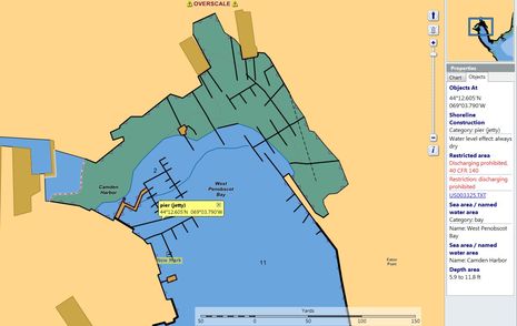 …like Google Map’s below. Note, though, that the Google photo predates the big changes that Wayfarer Marine made to its marina area seen on the upper part of both images. The ENC representation is much closer to ground truth, even if it doesn’t reflect the extensive dredging that’s taken place over the years (why all the yachts in those slips don’t actually go aground at low tide). I know I’m quibbling over minor details, but, gosh, if you’re going to this much chart updating trouble, why not go a bit further to get it right?…
 After all, these charts represent the official source data, which will be slowly but
surely copied to all the commercial charts because it is the official
data. And while I know that there are numerous corrective processes in
place, I’m a little leery about how long they’ll take. I just got an
email response this evening to my discrepancy report of June 29, and all
it says is that a question about the buoy locations and numbers (as if)
has been sent to the USCG. Which corresponds to this rather Catch 22-like statement I
got separately from a NOAA regional representative:
As
for the inaccurate position of the aids, NOAA charts what is known. NOAA looks to the US Coast Guard as the authoritative source for Aids to Navigation. The maintenance and movement of Private Aids is generally not reported to the Coast Guard once they have been established. Therefore, the Coast Guard has no update to report to
NOAA for charting action.
Hopefully
I’m wrong, but I think that good old non-existent Can 13 is going to stay on
the Camden Harbor chart for a while because…well…now it’s official.


Ben,
Hopefully the USCG can do things faster than the US Army Corp of Engineers, who maintains all our aids on our small 30K acre lake here in DFW.
Our “slow no wake” buoys blown around during storms and lake level changes and the move right into the middle of the channel or are blown a 1/4 mile father out from where they should be and they sit there for a year or more before someone gets around to fixing it. Some of them are 1/2 underwater and covered in growth and you can’t pick them up on radar anymore and you can’t see them as they are a nice green color.
Chris
As anywhere else, the squeeky wheel gets the grease in government bureaucracies. It appears no one has ever mastered squeek control or squeek metering, but the old reliable “Stone Wall” technique serves best. If closely examined, we might fine that all this input must be left to ripen in some GS-11’s in box, who has two other jobs and three bosses!
I just found out that the Harbor Master did file an application to make the channel buoys official private aids about three years ago. He does not remember including lat/long locations, but maybe he did, and hence maybe he or some typo is the source of the mislocations.
There has been a related problem in Southwest Harbor ME. The Great Harbor Marina at the head of the Harbor has a massive pier and extensive docks, but most of that has not shown up on charts for at least six years or more. According to my Navionics ENC charting, and NOAA paper chart, there are no docks there although the ledges protecting them show, but somewhat vaguely relative to what you might think is the marina. Finding this marina in dense Maine fog is therefore problematic if you expect to see what is pictured on the charts. As is usual downeast, local knowledge is important.
Ben,
Here’s the light list. http://www.navcen.uscg.gov/pdf/lightLists/LightList%20V1.pdf Your marks are on page 39. If the listed positions are correct, then I would agree that this is a NOAA issue. However, if the listed positions are incorrect, then it seems that you need to take this up with the Harbor Master and the Coast Guard as they are providing the incorrect information to NOAA.
In response to your statement: “The reality that all those numbered cans and nuns above are in fact unnumbered round balls or even “no wake” pylons seems like a good example of why such a ‘uniformity’ policy can be confusing.” Note that 33 CFR 66 requires that private aids conform to the characteristics of normal aids to navigation. That the “private aids” are unnumbered round balls seems to be an issue you should take up with the Harbor Master.
Many Many private aids are not registered in Maine. In channels and around the islands. They like to move some around and also disclaim ownership. The USCG has no time and staff to manage the Patons. It is unlikely they will come and verify that they are properly registered and located as specified. If the owner of the registered and unregistered Patons does not register them and maintain all including their positions the chart data and light list data, if even available, are suspect.
Patons need to be verified, plotted against the latest NOAA chart and sometimes older versions, compared to the LL, compared to the CG’s files. If they are not registered they should not appear in any of those places except the CG if someone has sent in the info. The CG likes to know about unregistered Patons but in reality has little resources to deal with them. Tracking back from Paton to “owner” can be a very time consuming process.
The various Classes of Private Aids to Navigation have inspection schedules. The inspections vary geographically depending on resources.
Carl, it is not yet clear who provided the wrong buoy locations, and it may never be, but don’t you think that NOAA is ultimately responsible for everything on the charts? Don’t you suppose there’s some quality control process? Have you ever seen a channel buoyed the way Camden’s is charted? If you were responsible for publishing that chart, might you have questioned it? Sorry, but the notion that anything on a NOAA chart is somehow not a NOAA issue bothers me.
I did not know about the 33 CFR 66 requirements regarding private aids, but that raises questions too. If the USCG, Auxiliary, or Power Squadron decide to chart private aids — as NOAA suggested possible (they didn’t even mention the harbor master) — is the owner of the aids then required to “normalize” them? In other words, can that expense be imposed on, say, a municipality like Camden that’s been content with its own aids for decades?
Also, do you have any thoughts on the “Priv aids” label that seems to be missing on the ENC, or the nonexistent charted pier?
Thanks, MaineFog. Now I’m thinking of Alice in Wonderland in addition to Catch 22;-) If registering and keeping track of private aids is an uncertain business, does it make sense to chart them very similarly to large and very well tracked USCG maintained aids? I’m sure that the Camden Harbor Master who first painted those mooring balls and set them out many years ago never imagined them charted as regular nuns and cans. They’d look sort of messy even if they were all properly located, especially on a paper chart.
I have learned that there are buoys made for this purpose; Taylor Made calls them “regulatory buoys” fittingly enough:
http://www.boatcovers.cc/cgi-bin/catalog.pl?item_id=73
They are fairly expensive, though, and I imagine the Harbor Master might reduce the number if he decides to switch over, generating more paperwork, LNM’s, etc…
Ben, since you asked, I would not personally have any particular problem with a bureaucratic division of labor where the Coast Guard is responsible for maintaining the list of aids to navigation and NOAA simply charts what the Coast Guard verifies. However, your predicament piqued enough of my interest to download the trial version of Coastal Explorer and the ENC including Camden Harbor. It appears to me that the actual mark locations, the light list locations, and the charted locations are all different. This seems to leave everyone on the hook and likely makes it difficult to get everyone on the same page to correct.
As for the issue of labeling the marks “private” on the chart, your screen shot of the marks shown in Coastal Explorer shows that the status of the object is private, so I’m not sure why this isn’t a Coastal Explorer issue.
My thoughts on the pier issue is that my experience has led me to not expect that such details are accurately charted. But I fully agree with you that if NOAA is surveying and updating the pier locations, they should do it accurately.
Thanks, Carl, but you didn’t address the issue of quality control. Of course it makes sense for the Coast Guard to feed buoy information to NOAA, but it seems like the CG uses multiple sources for private aid info, possibly without checking its validity. Then it seems like NOAA is willing to publish that data even when it is as obviously odd looking as those screwy Camden Channel can buoys. That doesn’t seem right.
I think the “Status: private” information contained in the channel buoy descriptions is analogous to having it in the printed Light List. Very few navigators will ever see it. But when those channel buoys were added to the paper chart, apparently it’s either standard to notate “Priv aids” right where every navigator will see it, or a cartographer made that decision. However it happened, it’s a valuable tip off that the following buoys may not be like all the similarly marked USCG maintained buoys seen previously.
Obviously important text like the “Camden Harbor” seen in the screen shot can be placed on an ENC. It should be possible to put “Priv aids” right on the ENC too. I realize that the ENC display software can hide text like that in an effort to declutter the image, but I do not believe that “Priv aids” is even there as a text label to be decluttered. I think it’s only in the ENC as an individual buoy detail, and that’s quite a different thing. If that was good enough, it would be like the paper chart leaving out the “Priv aids” label because you could find that out in the Lights List.
I suppose the display software could be made to write “private” next to every buoy, but I think that would an especially unusual way to use the ENC data, and it still wouldn’t be as effective and efficient as that single big “Priv aids” notation right at the beginning of the channel.
I’ve seen this sort of important text loss from paper chart to ENC before, and I think it’s disturbing. Check out the “Cribs” on the Kennebec River at the bottom of the entry below. The paper chart (and of course its RNC equivalent) properly calls them out as hazard, but you’ll only get that info from the ENC by clicking on the rather vaguely symbolized objects.
https://panbo.com/archives/2010/06/alliance_for_safe_navigation_chart_reality_questions.html
Remember that ENCs are the charts of the future, and paper charts will likely go away eventually. I thoroughly believe that ENCs can be best charts ever, but it may take lots of constructive criticism on the part of users to get there 😉
“It appears to me that the actual mark locations, the light list locations, and the charted locations are all different”
This is not unusual. Patons that are not permanent are often not put back in the spring in the same place. Some that are left in year round are relocated by ice movement and may stay at the new location for a long time. There is often a long delay between reporting/registering and having the information appear in the rest of the chain. So an error or change could be in transit so to speak, at different speeds among the various entities and publications.
This is why it can be very time consuming to figure stuff like this out and trace the route of perhaps bad info.
In Maine the Harbormasters have an online database for the private aids. Some use it, some don’t. The CG has no resources to deal with private aids. However if there is an area of risk in a navigable waterway that the general public uses, the CG may opt to place an Aton that they maintain instead of the private aid.
“But I fully agree with you that if NOAA is surveying and updating the pier locations, they should do it accurately.”
NOAA also has financial and resource limitations. It would be unusual for them to come out and survey Camden and similar areas. Someone has to do the homework and report marine features such as shoreline changes and facilities. If Camden sent surveys, photos, actual construction prints, a chart with the camera locations and directions, walk the piers and take waypoints, Google Earth pictures etc. to NOAA, they would probably include the harbor changes in a new chart release.
Given that the rocks do not move around in Maine and that there is not a lot of commercial traffic in small harbors, any chart update will be in a line with many others, some more important.
I am doing a chart update document for a small area off the Chesapeake Bay where a private aid has been relocated as part of a marina expansion. The charts and LL have it at the old location for years now. I will revisit the area again this summer to verify all is still in place and complete an information package for submission to NOAA. Many hours of work. Very important though because fuel facilities have been moved. You would have thought the owner of the private aid would have updated the registration.
I am hoping for a ride on Gizmo later this summer for a tour of Camden Harbor to see this mess. When is Gizmo going on the hard for the winter?
Last season in Danish Limfjord we had to go around a shallow area. There was a buoy charted at the entrance of a channel and I asked my friend to steer to it to avoid the shallow water. When I checked on the chartplotter, we were headed straight for the shallows. It turned out that the outermost channel buoy was missing. On the official danish raster chart, it looked like an official buoy but when we passed through the channel, the others were all private.
I don’t see how I could blame some danish marina operator for not matching his private aids to the chart but I do blame the danish hydrographical office for charting these buoys. Had they not been charted, I would have set up a waypoint and given my friend a course to steer.
A few weeks ago, we passed by a small private dock in another shallow body of water (the “Schlei”) where I saw several 45ft sailboats with 50ft high masts in a charted depth of 2 to 3 feet. Dredging had obviously been done recently. There was no charted channel to that dock but when I looked close, I saw the text “channel 2m” on the chart. At the time, this put me off because the place is 1/4 mile from the head office of the maker of the chart I was using (NV, “Nautical Publications”). If they had gotten their butts off of their chairs just a little, they could have probably seen the buoys from their desks. Close by there is another such channel to a larger dock that has two dashed lines marking the width of the channel and text “channel, 2.1m, marked” but also no buoys charted.
I retrospect, I take back my criticism. I now think that this is the best way to deal with private aids – just slightly indiciating that there may be something there that may help a navigator but no individual buoys and certainly not looking the same as official buoys.
A friend pilots a police helicopter in Hamburg and it is one of his regular duties to check on the positions of the official nav aids in the Elbe waterway. No more than a few days would pass before a drifting or relocated buoy would be reported. Of course, if the Elbe waterway were blocked by an oil tanker aground, Hamburg as one of Europe’s largest ports were cut off completely with disatrous financial consequences so you can’t really compare.
From this thread and my above experience I am now convinced that private nav aids should not be (individually) charted on an official chart and also not added on to official data in privately produced charts like C-Map and Navionics. If they are charted, they must absolutely be clearly identified as private. Instead, there should be text indicating that they exist and, possibly, a graphical indication of the direction of a channel.
If buoys are charted for which no institution is tasked with (and paid for) maintaining them afloat, painted and in the charted position, then people like will will tend to steer to them rather than checking the boat’s position on the chart which has almost put me aground.
I will happily use a privately marked channel but I will use it with greater confidence if it isn’t charted that if it is charted but the charted positions don’t match the real ones.
Well said, Henning. I’m not sure I go along completely, but do agree that private aids should at least look less significant (and more uncertain) on every form of chart, without having to dig down to find out they’re private.
I did not seek local publicity about this buoy business, but the local paper took a crack at it nonetheless. The reporter misunderstood me on some points (or I misspoke), but did fairly well overall:
http://knox.villagesoup.com/news/story/federal-charts-misplace-camden-channel/337155
PS Also kind of funny that my $400 used police car computer made the front page 😉
“I am now convinced that private nav aids should not be (individually) charted on an official chart and also not added on to official data in privately produced charts like C-Map and Navionics.”
I disagree. Permanent private aids should be charted. The laws requiring maintenance of any private aid are there, they need a little enforcement. Since there is no agency to monitor and write the ticket no maintenance can be the standard. All the Patons placed by states are Private Aids. Many are pylons or dolphins etc and are considered permanent structures. Why leave these off a chart?
The seasonal aids and speed bumps that harbors and marinas place in the water can be put back in various positions and aids that have been dragged out of position sometimes never get returned to where they started. Adding these to a chart could be like herding cats.
“If buoys are charted for which no institution is tasked with (and paid for) maintaining them afloat, painted and in the charted position, then….”
The owner of record is responsible for maintenance. That can be a person, town, county, marina, state. Many are not registered to avoid being responsible or it’s too much paperwork or “I did not know”.
The aids in the Camden channel were placed in the sixties but only registered 4 years ago. Those registration docs should be reviewed for the original plotted positions. Some of these could be wrong.
This can be compared to what is current at the ANT in Southwest Harbor. If the original numbers are correct and the CG numbers are correct and the balls, properly labeled or not, are in their correct positions, how did the off location balls get charted? NOAA will have a record of the source of their data. If there were some errors in the original registrations, they may just be finding their way through the chain.
Private aids as I see them are ball fenders, the red ones left at the day-glo red color and the green ones painted over or they may be old fuel cans painted (I’ve seen this).
If in the US state-owned and operated navaids are also considered private then that’s a different thing. The state will have some official body charged with operating these aids and they are probably not in addition to “official” (federal?) aids but replacing them, meaning if the state hadn’t put them, the federal government would have had to.
The private aids I mean, and for which I think you agree that they should not be charted (“like herding cats”) are likely put up by knowledgeable, well meaning people that have a host of other tasks to do. Some may put up the aids on their own initiative. I would not like to see them being fined for their trouble. And even if they are just faced with a pile of regulations, I would think that they don’t take well to that and may decide to reduce or remove their aids, possibly giving a reason such as “In my position I can’t guarantee correctly set and displayed aids and since a guarantee is a legal requirement the only thing I can do is to remove them”.
Another story: on one of the first trips of this season we visited a shallow natural harbor in an otherwise beachy coastline with a marina in it and where the cut is made navigable by dredging (“Marina Wendtorf”). There is a channel and the chart says “channel, mainained depth 3m, lesser depths reported” but this time, the buoys are individually charted. I don’t know if these buoys are private but, for this discussion, let’s assume they are.
When we went in in moderate following seas I noticed a distinct curve in the channel to guide us around a shallow area that apparently had developed after the last dredging. We had no more than a foot of water under the keel in some places.
Over night the wind turned onshore and increased. In the morning, we had to beat our way out dead into a 24 to 28 knot wind and breaking surf. In this different light and with the breakers, I could no longer see the sandy patch at all. The rig oscillated each time we dropped down off the seas with a loud bang and we hit the ground a few times in the troughs but not hard. We got out OK but the buoys and that they had been adjusted recently was a life (or boat-) saver.
Let’s not do anything that is going to make this place’s harbormaster remove his buoys. And also, let’s not fine him for changing the buoys from the charted locations to reflect a channel that has shifted due to sanding.
Although not appearing on my charplotter either, they were a welcome site as I entered Camden harbor last Tuesday from a fog filled adventure that day.
This brings up the subject of Information 2.0 and whether mapping information should be solely managed by a central source like the government or whether there is a way the public can participate is keeping map data current and accurate. See Crowdsourcing.
There is a lot going on in the street map space, traditionally owned by two private companies, where a sort of Wikipedia of mapping has been making an impact. It is called OpenStreetMap. Perhaps someday this idea will be applied successfully to marine mapping.
Thoughts?
I am all in favour of crowdsourcing
– it is the very reason why we refer to wikipedia – a source which theoretically is totally unregulated, but practically is more regulated, accurate and dependable than most “regulated resources”
why do we not have any crowdsourcing website for information on ports and harbours??
Even google earth nc (nautical charting) has not really taken off much.
Dear Anshuman,
have you heard of Openstreetmap?
They are working on a nautical chart solution.
Please check out:
http://map.openseamap.org/map/map_edit.php?lang=en
Start mapping! 🙂
Regards
Katrin