
Furuno NN3D charts, some issues?
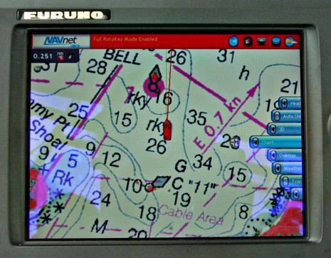
The good news is that more Furuno NavNet 3D MFDs are getting delivered and installed; the bad news is that some of the first users aren’t happy with the charts, neither the rasters nor the vectors. For instance, the two empty MFD12 holes we saw a while back are finally filled, but now the owner—Hull Truth poster “PSW”—is wishing he could use Navionics cards in his MFD12s, as are fellow posters “srmote” and “snowpup”. And I know that our own frequent poster Russ was not pleased with his first look at the charts on his MFD8. My own NN3D experience off Cape Cod did not leave me nearly as negative, but I did note some weaknesses. It helps that I like raster charts and am used to plotting on them, but I didn’t think they worked very well on the 8” display, as suggested in the screen above. Some other levels of zoom/chart scale looked better, and some worse. 3D perspective can put more info on the screen—and fast panning/zooming make it all more tolerable—but there’s just no getting around the fact that you’re looking at a large paper chart through an 8” window. The rasters looked fine to me on the 15” display that was also on the test boat, and I’d guess they’d work OK at 12” (but the Hull Truth gang don’t seem to think so).
The vector story is harder to pin down. I didn’t use them much off the Cape because they seemed light on detail and I presumed that the smaller area (large scale) charts had not yet been vectorized by NOAA (unlike rasters, the U.S. S57/ENC portfolio is incomplete), and hence had not been turned into NN3D charts by MapMedia . But when I later checked the ENC coverage using Coastal Explorer, I found that the coastal 1:40,000 charts in this area are available (though the 1:5,000 harbor chart of Woods Hole is not). However, when I compared one of the few vector photos I took with a CE image of the same area—below, and bigger here—it seemed to correspond fairly well. But I’ve also seen a screen photo that Russ took in Maine, similar in zoom level and available chart detail, but with no spot soundings at all! I’m guessing that Furuno needs to tweak its vector presentation, but also that boaters used to Navionics/C-Map/Garmin vectors will not be totally happy with NOAA S57s until all chart scales are complete.
And what about NN3D charts outside the U.S.? My understanding is that wherever MapMedia (part of MaxSea and hence a Furuno partner) currently has raster charts, like the U.K., they have been (or will be) converted into the NN3D-friendly format (actually called “.mm3”). In other parts of the world, like the Bahamas, the chart data will be in vector form from Navionics. But apparently converting Navionics to .mm3 has been a little tricky, and I’m not sure anyone has seen any yet. (I believe that the Bahamas are set to come out soon {they’re out, along with most of North America}, but have heard that Bermuda won’t be available until early 2009.) So it appears that for areas outside the U.S. there will be either rasters or vectors, but not both, at least for a while. And, mind you, neither format comes with POI information or panoramic harbor photos, though they will usually include bathymetric data and hi res photo maps. Yes, I know I sound vague, but that how it seems to be. After all, Furuno bit off a huge chunk here, deciding to produce its own charts on top of a radical new MFD system. The end results I’ve seen are fantastic, but anyone wanting to get a boatload of NN3D gear and go anywhere may need some workarounds, and some patience.


I have the 12″ unit and had my dealer install the Bahamas last week. The dealer showed me that when he did this, the Bahamas were added and additionally, all of the NOAA Vector Charts on the unit in South Florida below Cape Canaveral were replaced by the Navionics Platinum Charts!! I didn’t know that this would happen but, I like the Navionics Charts and didn’t realize I would get them as part of the Bahamas Chart Pack. I called Furuno and they said that this was normal. They also suggested splitting the screen and running two charts together at different ranges or pushing the 3D Button to look further ahead at the same range to get a better perspective when looking at the Rasters because I had a similar problem of looking at a paper chart on a smaller screen. This works pretty good for me.
Maybe Furuno will allow customers to install the Navionics Vector Charts anywhere they want in the future as long as they pay for them.
Bob
That is startling news and very welcome. If there is a way to augment the MM3 charts with Navionics I would really like to hear more about that, both to improve the chart quality, and to supplement the coverage.
I’m sure I’m not the only one going south this fall that wishes there were charts for Bermuda. I’ll have a state of the art radar, and a paper chart.
Thanks, Bob! I want to make it clear to readers, though, that the only Navionics data in the NavNet 3D chart region is the charts themselves. As Furuno puts it: “The vector charts datacore is by Navionics and then converted to the TimeZero format.”
I don’t know where Furuno/MapMedia sources its photo maps, but I’ve heard that what they offer for the Bahamas is the best around. Have you checked them out, Bob?
Our problem in the Northwest is the lack of Canadian
charts. They are saying mid July now.
Canadian charts in Mid-July? But where do we get the NN3D boxes to run them on? <wry chuckle>
I have had two (8 and 12) on order for a while. Now I’m doing all kinds of kluge work-arounds on the installation of other nav systems (something else to gateway old 0183 stuff, temporary mounts for DSM250 and AP24 head since I don’t want big gaping holes in the pilothouse helm, keeping an old GPS, lots of temporary cabling, working on borrowing a chartplotter to get me through an upcoming adventure, etc.). I’m really looking forward to being concerned with the available charts… at the moment, the product line still feels like sort of an abstract leap of faith… though I still believe it’s going to be good eventually!
</rant>>
(But it’s good to hear the news about Canada, YSNW… hi from La Conner.)
Steve
Ben,
I didn’t realize it but, you are right. The Bahamas Sat Photos in the chart pack I bought are very detailed and better than the charts in many areas. My dealer told me that they are better than anything else on the market. It’s funny that Furuno hasn’t really said anything about these high res sat photos.
Bob
Thanks, Bob. I know that photo maps are very valuable in the Bahamas, where the official charting is pretty poor. The Bahamas are quite unusual that way; most of the major chart vendors are now using data from private cartographers instead of, or in addition to, tracing the official charts.
I wonder if that’s what Furuno means by a “new and improved {Bahamas} data set that will be available in Fall 2008?” Maybe they are using Navionics older data set now, and will be going to the new one—some of which Navionics collected itself—in the Fall?
FYI.. It appears as though Furuno is attempting to address some of the missing charts. They same some mid level charts are missing and a few detail charts are missing.
http://www.furunousa.com/Furuno/Rooms/DisplayPages/LayoutInitial?Container=com.webridge.entity.Entity%5BOID%5B79309AE8584C7C478EE4A207F622284F%5D%5D