
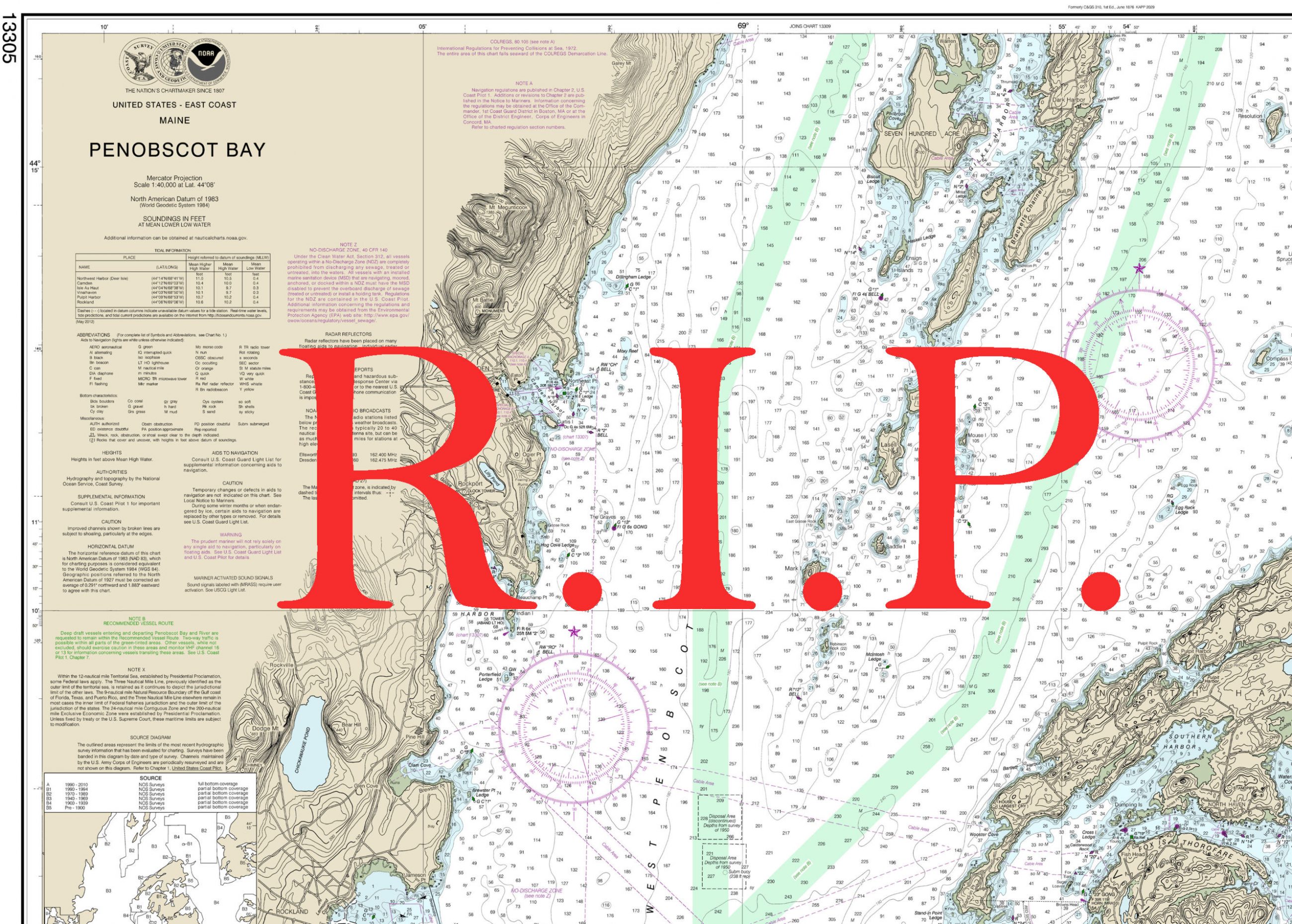
NOAA will sunset traditional nautical charts, sad but inevitable
Things are just things, right, and they don’t really die. But during a recent conference call with Capt Chris van Westendorp, Marine Chart Chief John Nyberg and several of their colleagues at NOAA’s Office of Coast Survey, a genuine feeling of grief bubbled up within me. And since I can’t keep my mouth shut, I learned that some of our “Nation’s Nautical Chartmakers” are also feeling the pain. The demise of the traditional chart is going to be sad for many of us, no doubt about it.
But please don’t jump to dire conclusions until you know all that NOAA plans. Traditional raster charts on paper or screens probably aren’t going away soon, paper charts are not going away at all, and many improvements in vector-based electronic charts are in the works. I’ll start by breaking down the specific plan announced today, and then go into why this hurts personally and what we traditional chart lovers can do to smooth the full transition to charts drawn by algorithms.
Sunset what?
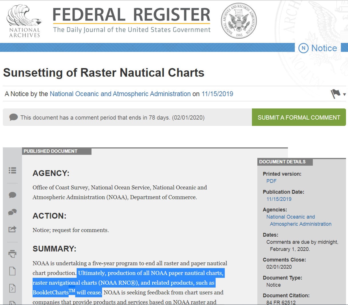
Yesterday’s official notice titled Sunsetting of Raster Nautical Charts references a more detailed PDF titled Sunsetting Traditional NOAA Paper Charts, and therein lies some potential confusion for boaters who don’t delve deeper. Traditional paper charts and raster charts often get mixed up because Raster Nautical Charts (RNCs) are simply a digital version of the paper product (or maybe vice versa behind the scenes). To be clear, NOAA intends to end production of all of their many traditional/raster products:
- Print-on-demand (POD) paper nautical charts
- Full-size chart PDFs
- NOAA raster navigational charts (NOAA RNC)
- BookletChart PDFs
- NOAA RNC tile service
- Online RNC viewer
Note that it’s already possible to produce paper charts based on NOAA’s primary Electronic Navigation Charts (ENCs), as detailed below.
Sunset when?
The decision has been made to sunset – that is, gradually and completely end – production of the traditional NOAA paper nautical charts and related raster products by January 2025.
Cancellation of these product and services will start in mid to late 2020 and be completed by January 2025.
Different NOAA documents describe the timeline in somewhat different ways, but that’s because they seek guidance about the transition from the boaters and companies that currently use these chart products. In other words, all traditional / raster NOAA chart production will definitely end by 2025, but some products — or maybe just certain chart scales, or certain regions — may end sooner, to be determined after efforts like yesterday’s OCS blog entry “NOAA seeks public comment on ending production of traditional paper nautical charts.”
Sunset why?
When NOAA’s National Charting Plan mentioned the eventual end of traditional / raster charts in 2017, the resulting ruckus motivated me to write “Is it true news that ‘NOAA wants to stop making NOAA charts’?” The raster product suite has actually improved in the two-plus years since — thank you, NOAA — but their eventual end has long been in the cards here and elsewhere.
For instance, an International Hydrographic Office (IHO) report on “The Future of the Paper Nautical Chart” cites the same issues NOAA does. As vector-based electronic charts have improved and also become the primary charts for large vessels, it’s becoming quite hard to justify the resources required to keep two chart formats up to date.
So Panbo readers boating outside U.S. waters take note. It’s very likely that we will all be navigating on vector charts eventually. So the only real issue, I think, is how well the transition goes for boaters like me who are believers in the traditional/raster chart style. And NOAA has obviously been thinking about this…
ENC to paper?

Actually, NOAA has already created an online Custom Chart Prototype that lets you create an ENC-based paper chart for exactly the coastal area you’d like with many options about how it will look. There’s obviously an issue with soundings in my example above — maybe a wrong setting, maybe a software bug — but there’s a lot to like in what seems possible beyond the prototype stage.
The soundings that did get into the chart image, for instance, are in whole number feet — as I wish many chart plotters could display (and just like my old paper charts) — and they’re also bold to the depth I chose. Moreover, I set the shallow water shading to my liking and the substantial PDF that NOAA created would print sharply on the 34 x 44 inch paper I specified (if I had such a printer).
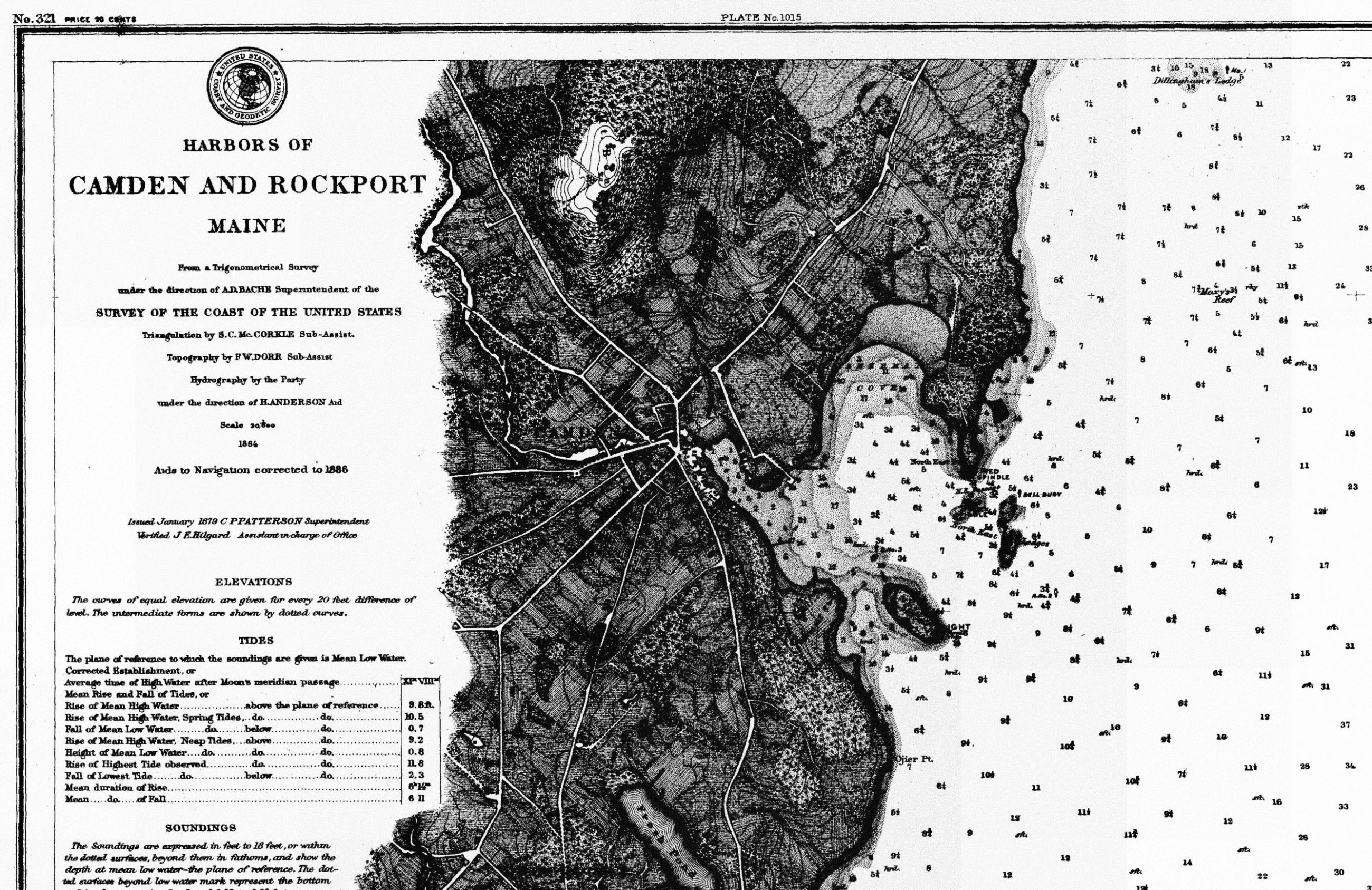
Admittedly, there are many valuable traditional paper chart elements that so far seem missing in the Custom Chart Prototype, but fixing that seems to be a priority at OCS. For instance, I understand that the paper chart creation system is close to including the notes and marginalia usually printed over non-critical land areas (as in the Penobscot Bay chart at top).
I don’t know if NOAA ENC charts will ever include the wealth of land detail that the rasters usually have, but it shouldn’t be hard for third-party paper chart publishers to add, as many electronic chart displays do. Hopefully then, products like MapTech ChartKits will continue to exist using improved ENC data to simulate the familiar and easy to understand raster style.
Actually I’m quite hopeful because I’m aware that NV Charts can already create very nice paper charts based on vector chart data. Maybe NOAA’s sunset plan will encourage them to update their U.S. chart books, and it’s definitely worth adding that NV makes their raster charts available for display in some charting apps and MFDs.
I also know that NOAA reached out to third party chart publishers yesterday, again seeking feedback toward making this long sunset a smooth one. But also worth noting: Commercial efforts to create and maintain new paper chart products won’t happen if boaters don’t keep buying them.
Better ENC?
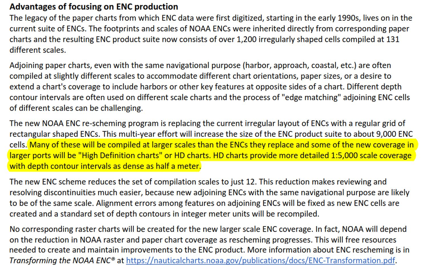
There are some large carrots in NOAA’s overall sunset plan. In the section above (from the Sunsetting…Paper Charts PDF), I’ve highlighted the larger scale (smaller area, more detail) charts promised. But the described “rescheming” of all ENCs to simplify the cell sizes, edges, and scales may make quite a visual difference too, because it should make life easier for the algorithms that are constantly assembling the vector data for electronic chart display.
And note how the rescheming is largely about organizing ENCs as if the cartographers had started fresh instead of copying the raster size/scale organization that was based on fixed paper size/scale printing. It’s another significant reason for the raster sunset.
Finally, I was pleased to learn on that conference call that the raster sunset does not mean the loss of any NOAA cartographers. They’re going to be busy rescheming ENCs, as described with more detail in the PDF titled Transforming the NOAA ENC.
Why so sad?
I realize now that my grief about the eventual demise of traditional charts is not about material things. When I use a raster chart — in my case, almost always on a screen — I feel like I can see the work of a human cartographer trying to help me stay out of trouble. Sometimes I even picture he or she putting a little more size and ink into marking a particular ledge because their expertise and human-level judgment skills can detect an especially dangerous hazard.
I do know that there are plenty of successful navigators who are content with vector charts, and I’ll admit to some romanticism about the traditional style. Plus, when cruising south, it does seem dumb looking at an upside-down raster chart (or my boat going down the screen in North Up mode). But then again, have you ever seen a vector chart with important town, harbor, and island names placed and sized just right so they’re clearly readable, as on most current raster/paper charts?
Moreover, I’ve seen too many instances where a critical depth sounding or rock does not show at some vector chart zoom levels where they really should. After all these years using almost every type of chart and display available, I still prefer a little human intervention over what algorithms and vector data can do.
And as if by magic, a far cruising commenter on the recent apps entry lyrically echoed my misgivings just before I finished this one.
What next?
I’m trying hard to reach the last stage of grief: acceptance and hope. And I think it’s just plain good sense to accept the fact that this is going to happen. NOAA is saying about as firmly as public servants can that that they will not be producing any traditional/raster content after January 2025. Period.
So even if you’re a raster chart lover aggrieved to the point of anger, I doubt there’s any value to filing a formal comment (before February 1) asking for a sunset reversal. But if you might print your own charts (for free) one day, try the Custom Chart Prototype and help NOAA improve it.
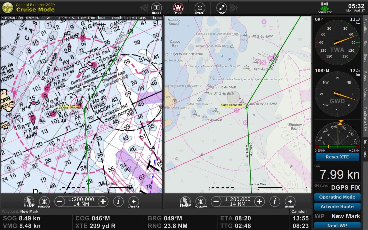
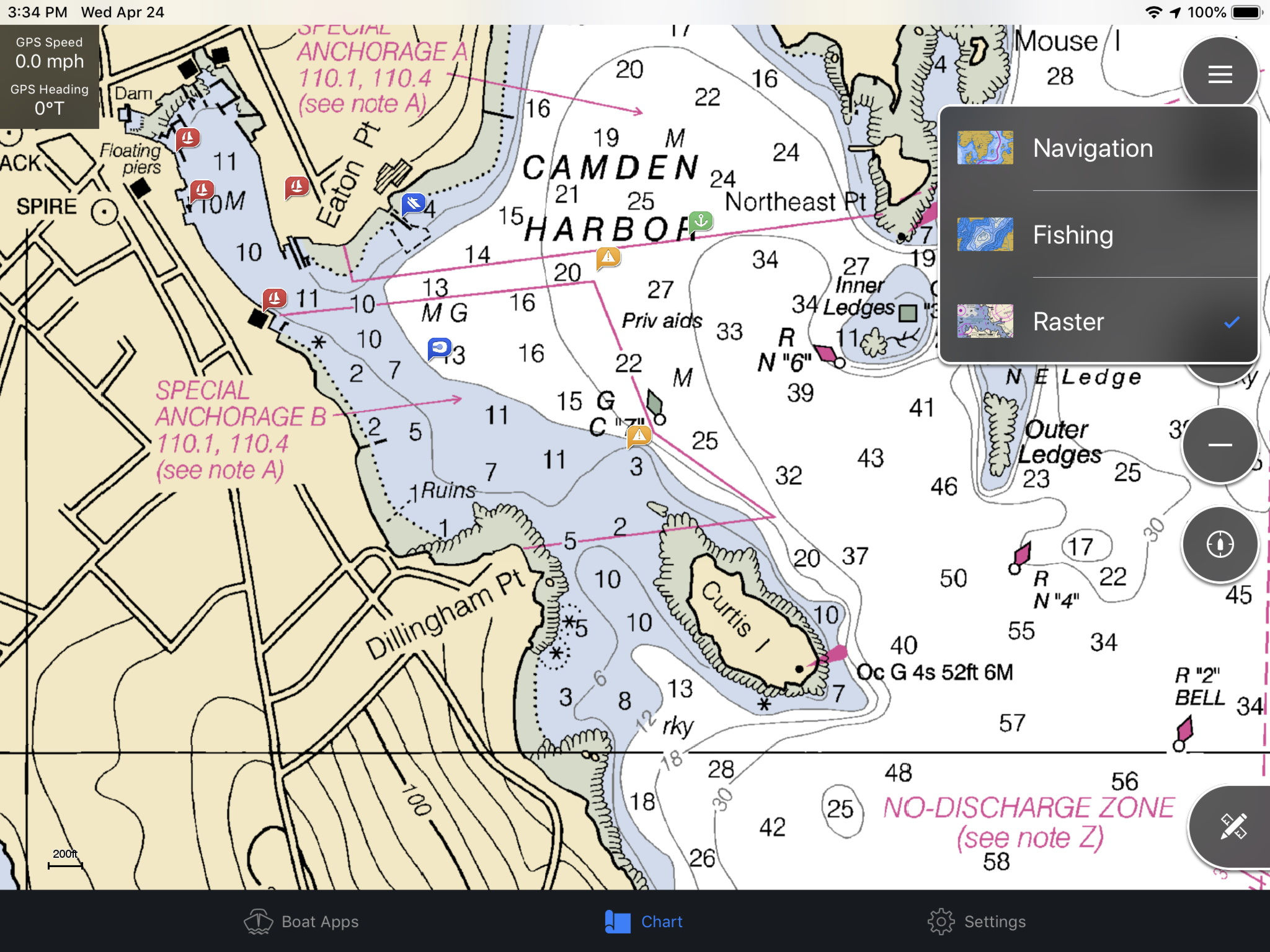
It also seems like a very good time to get familiar with NOAA’s (free) ENC charts (if you aren’t already). There are numerous apps, charting programs, and some MFDs that display them, and it’s particularly valuable if you can window them side by side with NOAA raster charts. The result, as in Coastal Explorer above, is a good learning tool for making the transition from traditional to “smart” charts, and also a way to find chart elements that you might like ENCs to do better.
But the very commonly used commercial vector charts — Navionics, C-Map, BlueChart, etc — are a trickier subject. Their U.S. coverage is all based on NOAA ENC data, I’m pretty sure, but often mixed with other data sets. And even the display of direct ENC data can vary from app to app or MFD because the developers have so much control over the display algorithms and user interfaces.
So lets all cast a more critical eye on our vector charts. Maybe improved ENC data can help electronics display better charts, or maybe improved electronics can display ENCs (and their kin) better. And making some noise about the specifics that could be better might help.
Finally, any comment I make to NOAA will include a thank you. We are very fortunate in the U.S. about how our government serves boaters, and I believe that the men and women of NOAA (and the USCG) have really stepped up to the task.


Good point on vector zoom levels. Something to get used to. Found out the hard, very hard, way in Nova Scotia
Hello Ben, you may easily imagine the interaction between your romantic emotions and mine: as you know, I marketed the world’s first seamless vector chart in 1983 and for many many years had to endure being treated like a blasphemous heretic.
Many many lives saved, and much better access to navigation on water, land and air, and now this indirect recognition by some of the very organizations that spared no effort to make me stop, remind me of a conference on the subject of electronic charts organized by the Royal Institute of Navigation in London; a Royal Navy Officer publicly called me a pirate, and I suggested that perhaps pioneer was a more fitting definition. There was a laugh and a handshake.
History and market and everyday life have proven that seamless vector cartography is just a safer and easier way to go,
It is like moving from the square rigger to the steamship: the transition is hard, initial mistakes are made, emotions are involved, the clean air blowing into the sails is preferred to the billows of black smoke by many, but eventually life moves forward.
However, I do agree that there is still a plenty of room for improvement both in the quality of the product and the education of the user. As I said in my farewell speech two years ago, artificial intelligence and scores of new technologies nowadays provide incredible opportunities for the electronic charts of the future, and as I retired I was excited to pass the relay to younger generations who will undoubtedly bring this torch to once unimaginable new frontiers.
Thanks, Giuseppe. I always thought that “swashbuckler” was a better description of your decades in command of the good ship Navionics 😉
Thank you for the “swashbuckler”!
as for charts, I should have added that, as the judge in the Federal Court of Australia found in a landmark ruling “all charts have errors” no matter if paper, electronic, government or private. The safest thing is to never rely on a single source of information.
If you actually cruised anywhere in your boat, you’d realize that paper charts and raster charts are well beyond their sell-by date. Their time is over. Put them in a museum or within your writing about how good it all used to be. For those of us out there, thank heaven fewer resources will go toward these useless products.
But I do remember when I thought I knew everything, Anon. Be careful out there!
Small dispIays… I sincerely hope raster will survive and live long as an option.
I’ve used Navionics on smartphone displays
and just started this summer to check out the freshly implemented vector option in NVcharts app.
A combo of raster and vector display can be used or raster only.
I’ve found for myself raster to be faster, more KISS and straight forward to use and less prone to user(zoom)error.
The smaller the display the more raster ( in conjunction with paper ) makes sense in my opinion.
Pretty sure its a different gmae on larger displays.
Zooming errors and flawed vector chart data with brutal consequences do happen also to pro navigators…
https://www.volvooceanrace.com/static/assets/content_v2/media/files/m36616_team-vestas-wind-inquiry-report-released-on-9-march-2015.pdf
From the report:
“Contributing factors were:
deficient use of electronic charts and other navigational data and a failure to identify the potential danger, and
deficient cartography in presenting the navigational dangers on small and medium scale
(or zoomed out) views on the electronic chart system in use.“
Best,
Jan
I suspect some electronics maker will come up with some sort of large size “projected” display which can be use on top of the chart table like a traditional chart. MFDs are getting larger and larger screens… but these are expensiver and expensiver… and out of the economic reach plus they simple are too large for many chart tables etc,
My 30+ year old has what is called a “full size” chart table which can support large paper charts. (BBA chart kits fit on there easily) and I typically keep one open to the region I am sailing as a big picture reference…. no need to zoom in and out and scroll and reverse.
Electronic data can be way more robust, can be updated almost real time… for sure pretty easily (can display the date of publication for reference), can filter what data is presented or the “granularity” can even show characteristics like flashing of aids to navigation, pop up data when “clicked on”… and of course layers With notes etc.), colors can be customized and so. It seems to this sailor that the possibilities for ENC charts make them ultimately far superior that a fixed date scanned product. Navigation needs to evolve to more open source… like a black box processor which you load software,.. charts, navigation computations, radar overlays, weather overlays, current overlays, AIS overlays and so on.. you can display on the monitor of YOUR choosing with interfaces which work for you… touch screen, mouse whatever.
I DO think having a paper product is a good idea and I suspect printed enc charts will be available commercially or navigators can print what they want and the size they want… and what “layers/data, scale etc to print) (sure few people have large format color plotters on board let alone at home).
We had a hard time moving from the IBM Selectric to the word processor… but now no one looks back and wants or needs them especially with interactive PDF forms…. the last use for a typewrite that I had
Is there a standard ENC format for maps?
I noticed on a B&G Zeus3 that the Navonics and CMAP products draw very differently. Is that because the underlying format of the data is different?
For example one product (CMAP I think) scrolls longer distances (finger drag), before triggering two screen redraws, first a low resolution render, then final high resolution render.
The other product (Navoincs) only lets you drag short distances, never jumping to a low resolution version. It takes many finger drags to move the map say 25 miles, unless you first zoom out, drag, and zoom in again.
My vision of how maps will be offered to us in the future, is driven a bit by my visits to StonyBrook University and their virtual reality labs, and a recent youtube video posted by Scott Manley explaining the impact on satellites on astronomy observers.
Unlike Paper Maps, the pixels on all our phones and MFD’s are a tiny fraction of what we have on paper maps, and the interface is kind of like looking from inside a tank, outside through a small window that moves very very slowly under the command of our fingers.
My vision for a paper map replacement:
1. Software drives a pair of google glasses or VR goggles that let you look down at a desk, or across the water, and “see” a map image move in front of you as fluidly as you can rotate your head. Push your face forward and back just inches to zoom anywhere. Such an interface would mimic having a map many feet across in either direction as if you had all the pixels you brain could possibly take in.
2. VR, but though a smartphone. Not sure if this link will work passing it through Panbo. If it does not, from your phone search “If You Could See Every Satellite, What Would The Sky Look Like” or “Scott Manley”
https://youtu.be/dJNGi-bt9NM
As in this video / VR combo (you can hold your phone up in front of you, look foward across land or water, and see a real-time map of man made objects circling the earth) .
Now imagine instead your smartphone is showing you a navigation chart instead and you can look at it by moving your phone in front of you either down at a desk, across a wall, or from in your boat, across the water, and “see” the navigation map image through the phone as if the map is stationary, and you are moving a magnifying glass over it. Push your phone forward or away just inches to zoom anywhere. Touch the screen to interact with the map (drop way points, measure distances, etc.). Such an interface would mimic having a map many feet across in either direction and would feel more natural to work with then dragging it with a finger across the screen.
The video I provided above is very good. It actually interacts with your phone as you move it.
Cheers
I confirmed the link does work as expected, at least from a Pixel 2XL running Android 10. Link repeated below
https://youtu.be/dJNGi-bt9NM
So someone started a petition to NOAA hoping to change the sunset plan:
https://www.change.org/p/national-oceanic-and-atmospheric-administration-stop-the-national-oceanic-and-atmospheric-administration-from-phasing-out-paper-charts
But sadly it’s all about how valuable paper charts are while NOAA’s plan includes support for a new type of paper chart.
If you’re already feeling nostalgic about traditional charts, this outfit may help you memorialize a favorite:
https://chartmugs.com/charts/?fwp_category=drinkware
Well, NOAA is really taking its time with sunsetting raster charts. The first one just happened and it’s a chart of Lake Tahoe that surprised me for even existing:
https://www.noaa.gov/media-release/noaa-begins-transition-exclusively-to-electronic-navigation-charts
I remember when our early electronic charts were considered blasphemy and heresy, and NOAA, along with most Hydrographic Offices, spared no effort to try to shut us down. This is history repeating itself, each time a disruptive innovation comes around. However, it is nice to see that NOAA has turned as a world leader into a new era
Looks like the sunsetting of traditional raster navigation charts is speeding up a bit:
“The NOAA RNC Tile Service and the NOAA RNC Viewer will be shut down on October 1, 2021.
The NOAA Seamless RNC Services will be shut down on Jan 1, 2022.”
https://nauticalcharts.noaa.gov/data/gis-data-and-services.html#gis-applications-viewers
According to a well-informed friend of Panbo: “This is going to remove U.S. nautical charts from a wide swath of web and mobile map apps and it doesn’t appear that NOAA is making any real transition plan to setup an equivalent service using ENC (or in a rational world just replace the RNC images with seamless ENC images on the same service for no interruptions).”