GeoCoastPilot, early adopters needed!

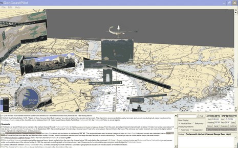
(Psssst!…back at work but need a little distraction, preferably for a good cause?) The screen shot above is worth seeing full size, but even then doesn’t do justice to the highly dynamic GeoCoastPilot beta program I’ve been entranced with for the last hour or so. The concept is an interactive 3D map that integrates official NOAA Coast Pilot textual information with vector and raster charts, bathy data, and panoramic photographs of key features. In this particular scene I clicked on the Portsmouth Harbor Channel Lighted Range link and the program lined up and highlighted a picture that might make it much easier to actually see the marks. When I then use the screen gizmo above the photo to tilt or turn the scene the photo changes if there are multiple shots available. There’s much more to it, as suggested by the choices at lower right, and for beta software, it seems to work pretty well. If you have a PC running XP or 2000, you go the GeoCoastPilot site and try it yourself, and you should!
Should? Well, as you’ll see, GeoCoastPilot is a joint venture of NOAA and the Data Visualization Research Lab at the—stand by for a mouth full—University of New Hampshire’s Center for Coastal and Ocean Mapping (CCOM)/ Joint Hydrographic Center (JHC). The researchers are looking for feedback on, um, how well they let you visualize the data. My first impression is that in terms of planning they’ve made it all work together in a more useful fashion than I’ve ever seen before. But it does look time consuming to create and I doubt NOAA will produce full Coast Pilots like this very soon (they’ve got budget problems enough already, as I’ll be writing about soon). But just getting ideas like this out into the public domain is worth CCOM’s and NOAA’s efforts, I think. So try it.


seems like a crude version of maxsea timezero
I think the only similarity between GeoCoastPilot and TimeZero is that they are both complete 3D environments that you can move through freely, as opposed to a limited 3D peek at what you normally view in 2D.
Beyond that, GCP is solely a data visualization concept while TimeZero is a navigation and planning application. Interestingly, a major weakness of the current TimeZero systems is a lack of POI data and panoramic photos. I think GeoCoastPilot could give the developers at MaxSea and Furuno some good ideas on how to implement those features in 3D.
By the way, does anyone doubt that the future of cartography is 3D?
I wouldn’t bet against the future … but if you put some qualifers on “the future” (e.g. how far in future, and what adoption rate would be evidence of success) and on “3D” … then, depending on the answer, I might be a doubter.
Is there an emerging technology that would allow measurements of large swaths of the ocean and inland water depths, with +/- 1 foot accuracy, for use in future 2D and 3D cartography ?