
User generated marine content, 1858 style!
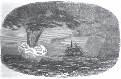
That’s not just an old drawing, it’s a sketch submitted to Mercantile Marine Magazine in 1858 by the chief mate of the ship Forerunner, and it’s accompanied by a detailed description of the spout (height of foam at base: 50’), the Southern Ocean conditions that produced it, and how Forerunner got out of its way! Mate Fletcher’s goal, of course, was to help fellow sailors understand water spouts better, and maybe brag a bit. I came across this bit of history in the most modern and wonderful way. I was Googling the name of a certain European lighthouse that might appear in one of PMY’s photo/chart contests, and one link I got was to the Google Books version of MM Magazine’s 1858 bound edition. And, mercy be, all 384 pages are searchable, downloadable, and fascinating.
Marine Mercantile in fact had very few illustrations in its monthly editions, a reminder of how verbal/textual early navigation was. We’ve come a wicked long way in 150 years, especially the 40 I’ve witnessed, but some things are the same. Know folks who are skeptical about anything but “traditional” navigation tools? Read them the compass diatribe you can find by searching the gbook for “Barlow”, like: “Professor Barlow, when directed by the Board of Admiralty to report on the state of the compasses furnished to the Royal Navy, said, ‘that at least one-half of them were mere lumber, and ought to be destroyed.’ {Many compass bowls then were wooden.}” Willing to learn from the mishaps of others? The Magazine is full of them, of course; search “Rodney” for a double grounding despite extraordinary celestial nav skills (“All four ships hoisted their longitude at noon of that day, which corresponded to a mile”).
Or how about the 1858 exchange rate for gold Doubloons, Eagles, or Sovereigns in the Cape de Verd Islands (search “de Verd”)? I’m sure many captains of the day cherished these volumes, and diligently contributed their own findings to the common database. Yes, indeed, the gray old Mercantile Marine is not really unlike the very graphic ActiveCaptain (Palm mobile application now available) and the various other marine “wikis” NavaGear is exploring. I’m confident that one day we’ll see a high-tech user generated POI system integrated into our onboard navigation appliance, and I’m also hoping for antique chart layers…for the historic dimension. Wouldn’t it be cool to see that old French lighthouse both underway, it’s still standing, and hand marked on an 1850’s chart by a guy who’d just read his latest Marine Mercantile?
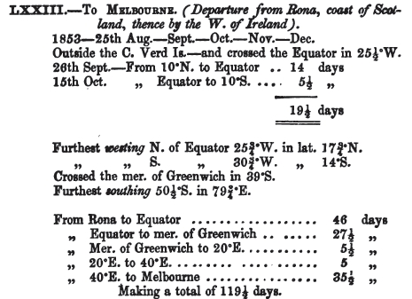
PS A question to ye olde navigators: I know the Greenwich Meridian is the great circle of zero longitude, which passes through the Greenwich, England observatory (because the Brits got to make such decisions back then), but is there a twist to how it’s used in the succinct MM voyage logs (like below)?


Recent Panbo Comments