
Garmin inReach Explorer+, armchair transatlantics & hands on
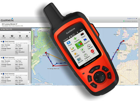
A big kick in my small life is seeing a technology I champion do well (especially when it involves a small company in Maine). I became a DeLorme inReach fanboy before it even shipped, and a succession of models have not let me down over thousands of testing hours. And I believe that the Explorer+ jointly developed with new owner Garmin is the best yet, based on personal experience and also on observing one serve well over thousands of transatlantic miles aboard S/V Lunacy (above). However, I also recently watched one Panbo reader suffer a very close call with inReach customer support…
 Before getting into details of the Explorer+ model, I want to emphasize how illuminating it was to watch an inReach-inexperienced friend use one in earnest. This is a fairly complex technology, at least when you dig into advanced features, and I’ve been using it so long I’m not well qualified to judge how difficult it is to learn from scratch.
Well, by gosh, Charlie Doane figured out how to activate his brand new Explorer+ just two busy days before departing France on his brand new Boreal 47 Lunacy, and, by the time the aluminum sloop arrived in Newport, 1,859 track points had been delivered by Iridium satellite to both his private inReach web account and also the online MapShare page that friends and family used to follow the voyage. Track points with boat speed and course appeared in near real-time every half hour for 5,060 nautical miles over 53 days (with three stops). In fact, share.garmin.com/Lunacy is now at least temporarily public so you, too, can zoom into the detail many of us watched closely, like the final few days to Bermuda after Lunacy lost its engine — new is not always a good thing — and then fell into an excruciating series of wind holes.
Perhaps even more valuable to the crew and families were all the messages reliably sent and received. 927 went out to various email addresses and phone numbers, and 729 came in via the linked inReach messaging interface or via the MapShare page. And all this messaging and tracking were done with a relatively inexpensive handheld device ($450) sitting in the boat’s doghouse (attached only to a USB charging cable), plus a $65 per month unlimited tracking and messaging plan (now suspended).
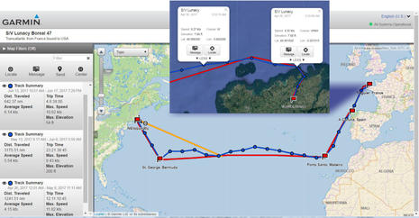
 I did help Charlie with Lunacy’s MapShare presentation, mainly by adding waypoints and route lines for viewer clarity. It’s easier to do that sort of thing right on the account map with an internet connection, but it’s also possible to push waypoints and bearing-to-waypoint lines from an inReach to the MapShare if you’ve permitted that in the MapShare setup.
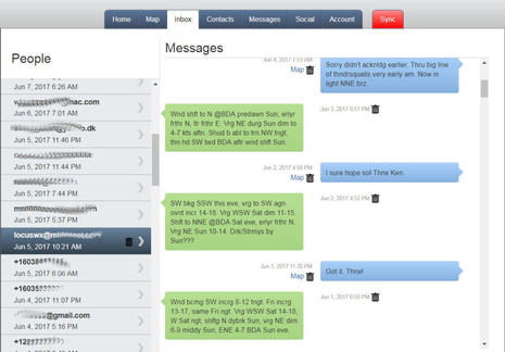
And because I have access to Charlie’s account (and got his permission), I took the screenshots collaged above to illustrate how a MapShare page is just a limited subset of all the information collected on an inReach owner’s private account site. Without doing anything more than turning tracking on and off at appropriate points and using the messaging feature, you end up with an interesting voyage log. You can, for instance, look back at all incoming and outgoing messages by recipient (shown further down) or at outgoing messages geopositioned or listed along with tracks (depending how you filter each). I savor my old inReach logs from time to time, and there are features most of us don’t use that could make them even better.
There’s more about how Lunacy used inReach for weather below and check out WaveTrain for Charlie’s own coverage of the trip, but meanwhile…
 …the morning after Lunacy made Newport, Tom Kiley departed Camden for the Azores aboard his lovely 37-foot wooden sloop Snow Star. Again I’m helping with the MapShare page, and again I’m enjoying regular contact with the crew, mainly because it’s easy and fun. Like when I realized earlier this week that there was a slight chance that Snow Star would encounter the oddball The Bridge “race” — four big French trimarans and the QE2 — and figured that propect might cheer them up, as they too floundered under the big Atlantic high (their engine works, but fuel is limited).,
Snow Star is posting track points and messages at an even greater rate than Lunacy (using the original Explorer model). That’s because Tom is using his plan’s most frequent track point send interval of 10 minutes and maybe also because they set up a Google Group before departure. Thus, the crew can group message all their friends and family using one address, and they’ve gotten into multiple message streams that add up to little stories, which often get lots of responses. Charlie worries that this sort of easy shore communication can distract from the essence of bluewater cruising — his Sail article on that subject coming in September issue — but it looks to me like an enjoyable and sometimes useful way to spend a little part of a long day at sea.
I’ll also note that both Charlie and Tom took along Iridium satellite phones, which were no doubt valuable for certain tasks and pleasures, but were also standing by if their inReach failed. While it’s great to give the assurance of constant tracking and messaging to friends and family, it’s potentially worse for them than, “I’ll try to call in few weeks,” if the inReach (or a similar tracker/messenger like The Spot Gen3 or the YB3i I tested in 2015) suddenly stops working.
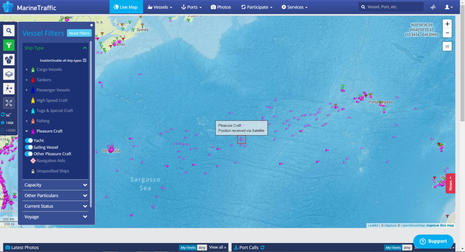 I’ll also add that while I vicariously enjoyed these transatlantics with just the info inReach tracks and a few text messages, armchair cruising is getting better in many ways. For instance, Marine Traffic now shows ships and boats far at sea thanks to satellite AIS receivers. So the filtered screen above gives a sense of how many pleasure craft were making transatlantics in late May and also enabled me to tease Charlie (highlighted) about going the wrong way. (Incidentally, I’ll soon write about testing a Digital Yacht AISnet base station and how it or similar can earn a user terrific Marine Traffic premium or pro features.)
And MV Dirona’s Newport to Kinsale transatlantic, which I also followed in May, is an amazing example of the detailed online tracking and logging possible with higher bandwidth satellite comms, a fully integrated boat monitoring system and — at least for now — a pair of owners as data savvy and armchair-cruiser-friendly as Jennifer and James Hamilton.
Explorer+ hardware
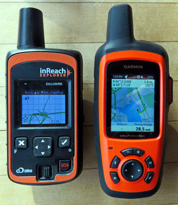 So here is the older DeLorme Explorer next to the Garmin inReach Explorer+. I believe that the DeLorme team in Maine was already well along with this design when Garmin acquired the company, and thus the “+” got some added Garmin engineering and is manufactured in Garmin’s Taiwan factory. It feels very well made, and those four added control buttons are quite useful throughout the handheld’s interface, which remains very similar otherwise.
The screen is also bigger and brighter, and that’s especially valuable because the Explorer+ is the first inReach that can display real maps. (Note that there is also a $400 Garmin SE+ model, though in my view it would be silly not to spend the extra $50 for the Explorer+’s added mapping, track memory, 3-axis compass and barometric altimeter.) As to complaints that Garmin jacked up inReach prices, they ignore the fact that DeLorme seemed to sell the core two-way Iridium 9602 modem at close to cost. The Explorer+ at $450 compares well with similar Iridium devices even without considering the rich set of interface, online, and app features that the DeLorme team developed around the modem’s capabilities (and which they continue to develop in the Maine office that Garmin is expanding).
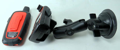 This photo shows the DeLorme inReach mount that I found very useful on Gizmo. As I illustrated back in 2014, it secured the handheld with a good-enough sky view in a main cabin window, where I could easily access the keypad when necessary (I prefer using the EarthMate app) and keep it powered with a USB cable. There’s a similar Explorer+ suction mount except that it includes an alternate, more waterproof power source. You can see the contacts at the bottom of the Explorer+ in my photo, on each side of the improved flap for a regular USB cable. Note, too, that the Explorer+ powered cradle is sold separately so that you can use your own RAM mount system with it.
 I doubt that many boaters will use the Explorer+ screen as a chart plotter, especially since the included EarthMate Android or iOS app can display NOAA raster charts while the handheld cannot. But the selection of maps that can be downloaded to the + is impressive (more below), and they can certainly be useful ashore.
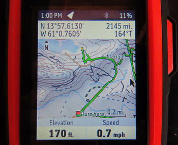
In the scene above we were exploring the lovely and rugged island of St. Lucia in a rented 4WD RAV, and I had used the iPad app during a Marigot Bay lunch to figure out an alternate route back. The “Turn here” waypoints created in Earthmate immediately appeared on the BlueTooth connected Explorer+ and were a real help as I again negotiated the wrong (left) side of narrow, steep, windy roads with almost no signage. Notice how the tracking shown is much more accurate than every 10 minute points, which I’ll soon explain.
inReach 4 ways
 An inReach comes with an extensive software and services ecosystem, and while you certainly don’t have to use all of it, I think it really helps to understand the general architecture. I’ll describe the four major parts while also pointing out some of the valuable but often under-utilized features. Above is the online inReach account site at inreach.garmin.com, where every owner must register their inReach, purchase service, and then wait a bit while the handheld gets authorized via the satellite system. (Garmin sometimes calls this site your Explorer Portal.)
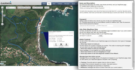
I’m pretty sure that some users like Charlie (so far) only use their account site (or Portal) to get started, and are still happy with the results. But there are numerous inReach features that can only be set up there, not in the apps and not on the handheld. In the collage above, for instance, I’ve shown the MapShare options I’m using for share.garmin.com/PanboInReach, where you can see the results.
Also showing is bit of my private inReach account map, which now holds years of testing data from all over the planet, but can be filtered, zoomed, and edited to see what I want. In this case it’s a fabulous St. Lucian beach preserve we hiked twice with big help from the Explorer+. The trails aren’t mapped or marked at all, but maybe that’s why the only other human we saw on the beach was a Rastafarian riding a horse bareback.
You’re also seeing an inReach Reference Point message, which is different because it marks a location you pick on a map or type in, not where you are when you create the message. They are sometimes used from one inReach to another so the users can both map and navigate to an agreed point. (There’s an enterprise inReach division, by the way, and military, too, I think.) But in this case I sent it to my special MapShare address and, thus, you can drill down to it at PanboInReach.
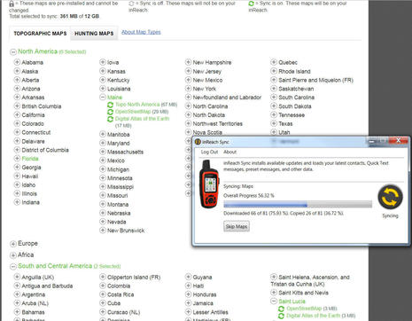 The Explorer Portal is also where you can download maps beyond the U.S. topos preloaded on an Explorer+. The selection is impressive, though I’m not sure that Lunacy would have found them for Madeira or Snow Star for the Azores. (They just sailed into Flores this afternoon, two weeks and 8 hours out of Camden and quite quick for a family-crewed 37-foot wooden boat nearly 50 years old, I think.) The downloading is done with a USB cable and a little PC program called inReach Sync that you get from the site and which is also needed for firmware updates.
“Sync” is a confusing term around the inReach world because it works to different degrees in different ways. The USB sync will also pass waypoints, routes, contacts, quick text, and other portal-created data to the inReach, but that can also be done by syncing the Earthmate app with your account when your phone or tablet is online and then syncing the app with the inReach via Bluetooth. The high resolution GPS tracking possible with the Explorer series can sync to your account site and MapShare either via USB or via Earthmate, and some nav items like waypoints can get to your account and MapShare via satellite, even if created on the app. Do you have a headache yet? (Good Garmin trip planning video tutorial here.)
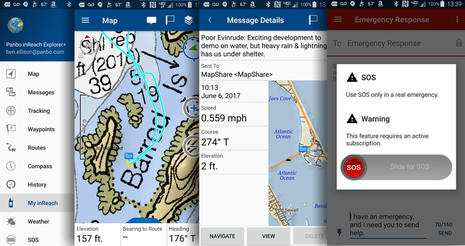
 The Explorer+ handheld interface is the only other software you have to mess with after setting up an account, but again I’m illustrating some of the features that require a little more study. Let’s start with the two messaging-related screens at right. In the “To:” section I could have typed in any email address or smart phone number, but instead I used the cursor and check keys to select the MapShare and FaceBook addresses from the right hand column. My Facebook account had to be set up at my inReach account page, and the inReach synced, but this message would appear on my FB timeline or Panbo page (chosen on the inReach account page) and also on PanboInReach.
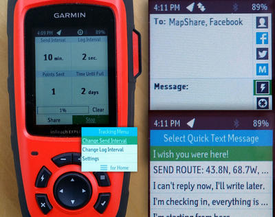
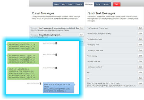
“Typing” a message on the inReach handheld is a chore, though the interface does offer some slick shortcuts and word prediction. Charlie used the handheld “keypad” exclusively — mainly because the Apple iTunes store would not let him download EarthMate in France — and reports that it learned some of the names and obscure words he used repeatedly. But I’m not sure he realized that the Lightning icon leads to a list of default Quick Text verbiage that can be customized on the Portal. Note my custom “SEND ROUTE…” quick text, further explained in the weather section below.
On the left side above you see the Explorer’s Tracking page, which shows how the Send (by Iridium) Interval can be quite different from the GPS Log Interval and how tapping the barred Menu key lets you change those intervals. (Note that you can’t change these intervals from the EarthMate app, or at least not the Android version I’m using at this time.) High resolution tracking does look good on the handheld, and is quite useful when bushwacking in a tropical forest, but it really shines when synced up to your account map, your MapShare, your EarthMate app or all of the above.
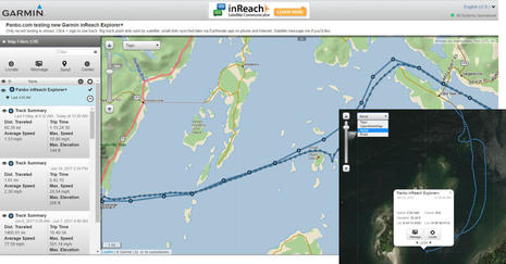 So here’s my MapShare again — let’s call it the third piece of the inReach puzzle — but its screen captured before I had synced the EarthMate app to my online account after the return leg of last week’s teaching trip to WoodenBoat School. Ten minute track points are more than fine for a transatlantic crossing, and for anyone wanting to know where Gizmo was in real time during this trip, but the 1 second track points I was collecting surely tell the story better, like around that poorly charted Barred Island ledge I’ve been trying to figure out for years.
I used to leave inReach tracking on for months at a time; it was easy and not too messy as it tries not to record track points when stopped. But I’ve realized from the transatlantics that more discipline has value. For instance, if Charlie had known to turn off his inReach in Spain, the average speed, time and distance of every Lunacy leg would be quite accurate.
A defined track can also be click-zoomed, and it would be excellent if Garmin made it possible to name them. In which case the three seen on my screen above might be “2017 WBS course,” “HQ to Gizmo via ebike & edinghy,” and “Evinrude event flight from FL,” though I decided to delete the latter at PanboInReach so you can better see how well inReach can work on a plane if you sometimes hold it near a window, as I did returning from St. Lucia.
 Finally, here’s the fourth inReach software piece, at least for mugs like me who like to use the EarthMate app to interface with the handheld and have a boat where that works nicely. I even wish I could switch easily from phone to iPad and back, but the inReach can only handle one Bluetooth pairing at a time (though I’ve seen such pairings “just work” for many months any time the devices were both on and nearby). Notice how EarthMate can download and display the NOAA charts not available on the Explorer+ and also how much detail is available for sent messages (in this case a MapShare notation).
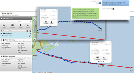
Also, note the SOS feature, an important aspect of the inReach system that I’ve never covered sufficiently. I did once discuss the coming benefit of two-way SEND technology — that stands for Satellite Emergency Notification Device, a standard that is not yet formalized and is distinct from the EPIRB/PLB system because it uses commercial satellites and rescue centers. But now it’s really working and the results collected by Garmin look good. I’d already read about how an inReach helped the Fletcher family aboard S/V Luna-C (boat names coincidental) in January…
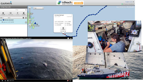 …but, holy cow, I only learned this morning that Garmin-sponsored OSTAR racer Michele Zambelli used inReach to exit his sinking vessel off Newfoundland in early June and even has a MapShare that tracked him up into the helicopter. That’s not a tracking map I hope to see while armchair cruising, but it certainly makes a good point. You’ll notice in the rescue descriptions that the two-way messaging was a real plus, and I also very much like how a system you know is working every day during a voyage can call for help.
This entry, incidentally, seems heavily oriented to transatlantic sailing, but inReach and other handheld SENDs are helping all sorts of boaters and others venturing beyond the relatively small portion of earth covered by cell systems, which don’t always offer fast professional distress response anyway. I’ll also note that there are existing and potential SEND/tracking/monitoring systems a lot more boat specific than an inReach Explorer+. I just started testing the SkyMate Mazu/mSeries this week (with Sentry monitoring), and I imagine that some of the big marine brands are at least considering similar systems with MFD integration, Garmin in particular.
Weather
 I’ve yammered on, but let’s go back for a bit to bluewater sailing and the all important subject of weather forecasting. I discussed inReach’s own weather service last year, but, oddly enough, neither Charlie nor Tom — who actually spent some time learning his inReach before departure — mentioned it, and neither did it pop into my cluttered brain (inReach provides a lot to discuss).
In fact, Charlie purchased his inReach mainly under orders from his longtime weather router Ken McKinley, which make lots of sense as Ken could easily track Lunacy’s position and text advice on his schedule, no sat phone calls needed unless the story got more complicated. Ken seems to have developed his own router shorthand, as seen on the portal page above, but Charlie said it worked fine on the Explorer screen, and Tom was doing something similar with Jennifer Clark’s routing service.
 Both sailors were interested in the new inReach integration offered by the online FastSeas routing service discussed here last November. But neither had the time to make it work for them as a secondary source, and both obviously believe in the value of human meteorological advice over the straight output of computer models.
However, I have successfully tested the FastSeas inReach feature, as seen in the message stream above, and what really helped, even using the EarthMate app, was getting the exact request syntax into that Quick Text form where I could use it easily with slight editing. Of course, it would work better still if inReach adopted the service or created their own, because then the request could be made much friendlier and the results could even be charted. But something like that could happen, with inReach or SkyMate or similar (and the new PredictWind/B&G integration — video here — is slicker still, though it currently requires a higher level of satellite communications).
I also used Lunacy’s passage to test FastSeas against real results. It was very easy online just to change the route prediction start point to the boat’s current MapShare position, and the results fairly often came close to Ken’s predictions and/or the boat’s reports. Charlie told me later that in his experience the model-based forecasting tends to understate the sharpness of weather fronts, and I had seen some evidence of that.
Issues?
 So, is the inReach system perfect? Hell no. I’ve seen a few intermittent glitches myself, like just yesterday when the waypoint I created for Porto Santo on Snow Star’s Portal (and hence MapShare) suddenly became the one I’d made for English Harbor, and stayed that way until I logged out and in again. Given all the platforms and syncing around the inReach universe, I believe that there a lot of moving parts behind the scenes. (Snow Star is not bound for Europe but instead touring Atlantic Islands en route to Antigua.)
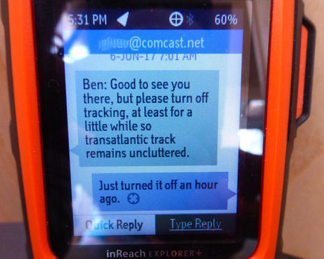
More consistent and more worrisome is how Lunacy’s Explorer+ regularly scrambled the source of messages. Charlie took the photo above after the voyage and I had started that MapShare scold message with “Ben:” because we’d already experienced the confusion of having my messages identified as coming from someone else. The same messages archived on Charlie’s acount site are all organized by their true sender, so this was only happening on the handheld, but it’s not confidence building.
Oh, and I did manage to completely jam my EarthMate and Explorer+ sync relationship attempting one second logging over a single 2,470 mile tracking session from St. Lucia to my house. You can see on PanboInReach that a lot of satellite and high-res track data made it to my Portal (and, incidentally, the Explorer+ was running on its own battery that whole 24-hour period), but I could not argue with the customer support response about this being “extreme use” and I had to factory reset the Explorer+ and reinstall the app to get things right again.
 But there are some serious questions about Garmin’s ability to deliver reasonable customer service on the complexity that really is inReach. Readers occasionally copy me on emails with electronics support staff, presumably hoping that I can intervene (I can’t), or that support will take them more seriously (who knows?), or that I’ll feel guilty about recommending the product in the first place (that works sometimes). To be frank, I sometimes feel worse for the support staff than the customer, usually because the latter doesn’t supply nearly enough information to diagnose the problem and then adds a dash of angry entitled seasoning.
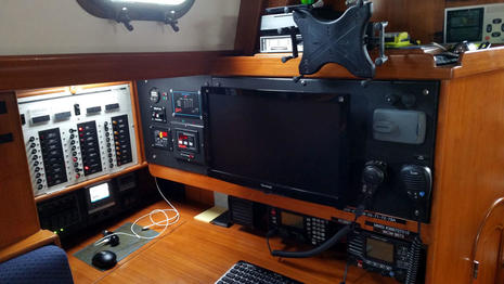
But Rich Cassano wrote a series of emails to Garmin tech support about his inReach issues that are as well put together as the nav station above that he created on Gray Eagle (and showed me in 2015). He was very polite, too, and once it became clear in the back and forth that his inReach worked fine as long as he did not sync it to his account, when it would again deactivate, I figured it was an issue obviously beyond his expired one-year warranty. But, as Rich explains in this Panbo comment, Garmin tech support did not see it that way.
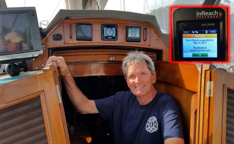
Now this particular story already has a happy ending, as Rich explains in yesterday’s followup, but you have to wonder what would have happened if he had not contacted an acquaintance in Garmin’s sales department. I also noticed this credible but ugly sounding Amazon report. Obviously, I remain a huge inReach fanboy, but my enthusiasm would change radically if I had experiences like Rich’s or the pilot’s.


Hi Ben, May I borrow for a day cruise?
BTW I was cruising St Lucia in May. Maybe. crossed tracks
Ben
Good discussion on the InReach device. Based on your earlier reviews I purchased one in 2015 to track a trip to Nova Scotia. It worked well and I enjoyed the comfort of having an emergency communicator – with two-way function. This I considered much better than the EPIRB that I also carried. Ironically, I had far better cell service in NS than I do in coastal Maine! – so the emergency function was less of issue than I thought.
I did have some issues loading maps to my phone interface after purchase but customer service was great and solved the problem over two weeks with email updates. (it was a general software issue related to their NS mapping downloads on their end that was corrected). Therefore, I have had a good experience with Customer Service. I did read the awful Amazon review you referenced and have to ask why has Garmin not provided some response in that comment chain?.
Last year I thought of using the InReach for tracking again for summer boating in Maine but the monthly cost seemed too high to me. I know that this is counter to your article but I wanted to find something that would be far cheaper and able to chart my course.
What I found that works well in coastal use is Spotwalla for charting combined with Bubbler GPS app for tracking. Spotwalla is free and the Bubbler GPS was $9.99 one time. The Bubbler interface is cell based so you need to have cell or WIFI for continual coverage – but the Bubbler logs points and stores until signal is present or you can set it not so send until you want so this minimizes cell use – which I found was very little even if on continually. So this really is a great service for me – and you can link Spotwalla to blogs etc for sharing (much easier than you can with the InReach software) – you can even control which trips are made public and which stay private. I will plan to use this on a planned Great Loop trip next year.
Thus, account the relatively high cost of the monthly tracking fee I will continue to use the InReach as a back emergency device (it is great for hiking in areas on no cell) and track locations of trips as noted above.
This comment is not to say that the InReach system is not good but rather to offer alternatives to those that are more coastal cruisers versus offshore users.
Looks like a great product. I’ve been using the YB Tracking system (fixed unit) which also works with the Iridium sats. These systems are a great safety device with SMS services for weather and quick “hello” type messages.
Ben, good summary of our first leg. All is accurate and yes there is still lots to learn about the device. We had lots of fun communications with family as a group, friends and public as groups too. Some messages were not shareable. The iPhone and/or iPad made life with the inreach much more enjoyable. I even used the voice recognition feature of the iPhone with moderate success. When back I will have a chat with Ken about our return in November.thanks for all your support and guidance. I owe you another lunch.
TK
Fantastic article Ben! Cool stuff! Amazing detailed information. Helpful, informative and so interesting to read! The 47 sailing away from Hamilton..and Michele Zambelli’s photos from the SAR requested US COAST GUARD Helo rescue…WoW!! Micheles boat looks soooo small in that big ugly sea apparetly some 350 nm so far off shore cape race/stjohns. It almost looks like he made it close to halfway to southhampton England!!if you click on the Garmin map tab and set it to “Aerial” instead of what the picture shows when its first loaded https://share.garmin.com/michelezambelli on aerial it shows a nice sub oceanic sea base chart illustrating eye candy with plates, sea mounts, oceanic ridges and shelves
Chart is geological structures in various blue font which you may know already. Anyway…Strong work Captain Ellison! Thanks for your work to create such a fine interesting and informative article like this to enjoy reading as well as to learn so much current detail about the “game changing and lifesaving emerging new software and hardware marine electronic technologies and products the industry continues to come to market with. Exciting times!
John Neyland Jr.
I received this suggestion/complaint:
“My suggestion is a comparison of Garmin inReach Explorer+ versus IridiumGO! This was a big missing piece in your latest post.”
I did actually try the GO! a couple of years ago but never really got the hang of using it, and ditto for Globalstar SatFi. I feel guilty about not reviewing them, but think it is fair to say that both require more user commitment than inReach, mainly because they are not as fully integrated tracking/messaging systems.
But that said, many bluewater cruisers report good results from GO! and SatFi, particularly if they’ve installed external antennas. They certainly offer more bandwidth, which means audio calls, semi-normal email, and richer weather forecasting.
I’ve also tried the SPOT Gen3, which is much improved over previous models. But it’s still limited to one way canned messaging, and the online tracking/logging service does not really compare to inReach in my view.
We have used an InReach SE for many years, and it has always performed well — very useful on both trans-Atlantics and on other offshore trips.
Now, however, the battery has apparently died — at least the unit no longer works without external power. Two emails to Germin support have so far produced no result.
And meanwhile, of course, my subscription keeps running.
I’m almost at the point of looking for an alternative.
I have a DelOrme InReach SE for 2 years now, paired with my iPhone. I’ve used it on 4 offshore trips as a tracking device and a satellite-style email. I use the unlimited messages subscription only when I’m offshore. I will send and receive several thousand messages (at 160 chars max), as well FastSeas routing and weather. I also get the OCENS marine point weather every few days.
It has all worked very very well, until this last trip where the order of some messages garbled, or messages would be received 3-4 times. This only happened on this last trip, which was the first time I used my device since it became Garmin. I don’t know if that is a cause or a coincidence.
I’ve no glitches with synching to my MacBook, but I only synch if the firmware needs changing, or a few days before I start a trip.
Typing on the InReach is a pain (I did it for a day when I missed the iPhone), otherwise the iPhone pairing makes everything easy, including having all my contact emails and FastSeas info.
PS I originally suggested the FastSeas implementation to Jeremy of FastSeas. He was great to work with, me as the tester, and you can get accurate routing information with course heading and wind information. Set your polars up on FastSeas before you leave and its a very useful navigation and safety package.
InReach is So VERY much cheaper than a SatBroadBand or SatPhone
Richard, regarding the garbled messages, please reach out to Garmin at [email protected]. These folks have viewed your issue on Panbo and are expecting your email.
Hi Ben,
Yeah, but… Purchased a new Explorer+ in May to use on a trip along the British Columbia coastline, where cellular connectivity is slim, and WiFi almost non-existent. Turns out, I was unable to pair it with my older iPad, much to my dismay. And given the spotty cellular connections in this part of the world, I was unable to resolve the issue until AFTER I returned:
(Received from Garmin technical support: “…I have reviewed the (iPad) model number that you provided and it does appear that the older iPad is using a different module to process data for Bluetooth to Earthmate. With that said, since the new device has a newer chipset, the device can be paired but will not interact with the Earthmate App due to this difference. This change was done by Apple when they released newer iPads and iPhones with the lightening adapter as it’s new standard.”
Not Garmin’s fault that Apple capriciously changes hardware (interesting business model, built-in obsolescence). However, Garmin does need to provide a hardware compatibility list with the Explorer+ so consumers can determine function BEFORE they need it. In my case, I need to drop yet another boat unit on a new iPad before I get full functionality from my Explorer+.
Sigh.
Regards,
Pete
Glad to report a (somewhat delayed) happy ending to my sad non-support story.
My third enail finally received a reply, and I was able (for $150) to send my InReach in to Garmin and get a refurbished replacement. Changing my account over to the new machine required another email to Garmin support, but after that I was able to sync the new machine and thus recover all my contacts and history.
So I no longer feel so negative.
Twitter just increased its character limit to 280 per message. Wouldn’t it be spectacular if Garmin did the same for inReach. Expanding the character limit would make the functionality of inReach far more useful then it is now and open up the possibility of sending and receiving more functional messages. If Garmin wants to sell more inReach Explorer+ devices this would be the way to do it instantly.
Sorry to report that Snow Star — now mid Atlantic, en route to Antigua — is having the same problem that Charlie Doane had in June with mixed up “sent from” inReach email addresses. I was hoping that Garmin fixed this, and it’s possible they did but maybe Snow Star has not updated the inReach handheld firmware. That update still requires running the inReach Sync app on a PC or Mac with handheld attached via USB.
It seems to me that several people are reporting problems with their Delorme designed inReach devices since Garmin took over. I wonder if the complete integration of Delorme will happen when Garmin designs their own Explorer ++, all new from the ground up? After all, I’m sure Garmin has their own ideas on how to take the inReach concept to the next level. The current model inReach devices have only slight updated features compared to the original, (in my opinion, not enough difference to make me run out and buy the current Explorer+). Does anyone have any hint as to when Garmin might redesign the Explorer+?
I did a video review of the Garmin Explorer Plus. I’ve used it in Russia, Alaska and the Rockies with great success:
https://youtu.be/TbsVRMdE3-Q