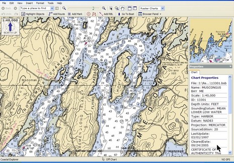
Gizmo rides again, and the SoftChart color palette appreciated

I took my first Maine boat ride of ‘06 yesterday (yahoo!), launching my 14’ power cat Gizmo at Broad Cove Marine Services in Bremen and exploring Hungry Island. The salty Maine expression for waters like these—i.e. lumpy with lots of hidden ledges—is “bony”, and I was a bit frustrated navigation wise. The only plotter screen onboard (silly me) was a tiny, poor-in-direct-sunlight Magellan. We did have a paper chart, but it was the reduced Waterproof Chartbook version of the most detailed available (1:40,000 scale), handy but hardly good enough in place like this where you where you really wish there was a high detail chart, like 1:20,000. At any rate it got me thinking about the SoftChart color palette I spoke of last week. Check it out: here’s full screen of the SoftChart above, and full screen of the standard NOAA RNC below. Don’t those rich colors clarify some of the important cartography? I wonder if Maptech will adopt these colors for paper as well as digital charts? I also wonder if the company will expect premium pricing for more richly colored charts?
Note to Coastal Explorer/CNP users: did you realize that right mouse clicks neatly change the scale of the chart overview window (as shown)? And finally, for a nice picture of Gizmo at Hungry Island, click here.


Quote, “Don�t those rich colors clarify some of the important cartography?”. Boy oh boy, they sure do.
The colourful Maptech chart looks really familiar to UK sailors. These are the standard colours used for Admiralty paper charts and digital raster charts (ARCS).
We like them too.
Yes, I should have mentioned that. Canada too. Maybe we shouldn’t have revolted so quickly?
Then, again, our hydrographic office distributes its charts for free. Yours, as I once heard, “wants to copyright every single depth sounding”.