AIS: Global SART detection, ASM info, & a bummer
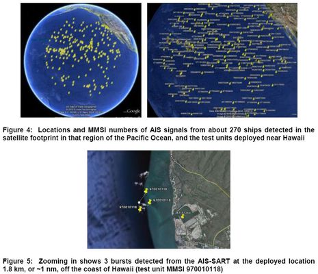
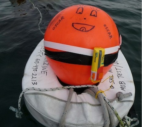
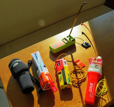
While exciting things are happening on the frontiers of AIS, there’s still some tragic ignorance about what the technology can do right now for marine safety, even from folks who should know better. But let’s start with the good stuff, right? After a recent entry about using compact AIS SARTS as crew overboard devices, USCG analyst Jorge Arroyo bombed me with documents about this and other AIS developments. I was aware that AIS SARTS have done well in testing with ships, planes, and helicopters, and I also knew that certain satellites were able to receive AIS signals, but who knew that there were “microsatellites” that can pick up a 1 Watt SART attached to a floating life vest from 1,100 miles away?…
You can download the test report PDF here {sorry, PDF gone}, and learn more about the sat system developer exactEarth here. You’ll see that their focus is monitoring regular AIS traffic (hopefully for a large number of commercial and governmental subscribers), and that the system is far from complete. And while there may never be enough microsats buzzing around to keep timely watch on AIS SARTS everywhere, just the fact that it’s possible boosts the technology in my view (though of course I’d still like to see how well a waterborne SART works when you’re trying to plot it from a small vessel in big seas).
Unfortunately, though, the many uses of AIS can lead to confusion, which brings me to the “bummer” part of this entry…
But I did take the opportunity at the end to ask if there was any news about the expanded AIS carriage requirements that have been in the works for almost two years, and include over 5,000 fishing boats over 65′. First one USCG presenter told me that fishing vessels were exempt from AIS with no changes planned. Then someone in the audience who had apparently represented Maine fishermen in AIS talks sometime in the past told me that the industry stance was that vessels which already had Vessel Monitoring Systems should not be required to install a duplicate identity system. When I said — nicely, I think — that VMS didn’t do any good for collision avoidance, the other USCG representative said in no uncertain terms that “AIS is more of a Homeland Security instrument than a navigation safety instrument.” When I brought up the IMO and all those ships going around the world with AIS — still nicely, I think — he boomed out “I don’t care what people have told you, AIS is the result of Homeland Security.” Yike!
It’s understandable why fishermen, and most all industries, are defensive about government mandated equipment. And while the Department of Homeland Security certainly didn’t invent AIS, it does value the technology for coastal security as well as collision avoidance, which may be confusing. But I’m pretty sure that the job description of the man so misinformed about AIS includes advising fishermen about safety issues. And I’m not sure he has a clue that there are such men who might be alive today if they had adopted AIS, like the crew of the Lady Mary, which just doesn’t seem right.


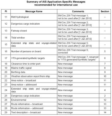

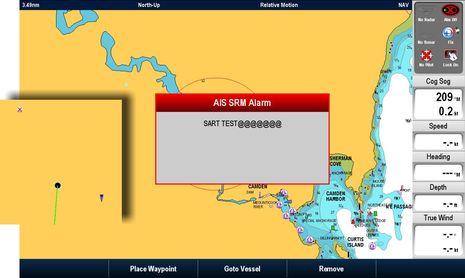


Exciting those extensions to AIS usage. But the more other uses for AIS there are, the more data traffic there will be. Already now we are fearing that class B AIS is being suppressed because of insufficient bandwidth – what’s gonna happen if class A starts using AIS’ precious bandwidth for other stuff than its primary purpose?
Ben, since AIS is conceptually a TDMA system do you see a practical limit to the number of messages (and consequently level of traffic) the system can handle in port and coastal areas?
The last time I looked AIS creation was assigned to Panama Canal pilots using carry-on equipment…
Any truth to that as far as you know?
C
My view is nobody cares about maritime safety. Homeland security and fears of the political fallout after another attack has sucked all the oxygen out of the room. (USCG SAR remains topnotch). As long as there are no front page photos of cute sea creatures covered in oil there is little incentive to do anything.
William Langewische’s The Outlaw Sea outlines, prior to AIS, the deep concern about the inability to see beyond the horizon. AIS is a very useful tool and it greatly reduces the workload for watch officers but that is an unintended benefit.
I don’t know anything about available bandwidth and so forth but I would love to sea a maritime equivalent of aviation’s ACARS (Aircraft Communications Addressing and Reporting System) aboard ship. For example coming into Singapore at night in heavy traffic I have to assign a mate the sole duty of trying to contact via VHF the pilots to arrange a boarding time. This task can take 20 minutes given the heavy VHF usage in Singapore.
Dennis, where is there so much AIS traffic that Class B is suppressed? I know that Class B is designed to work “politely” around Class A, and that AIS bandwidth is not infinite, but I have not heard of actual cases of system overload.
The IMO’s ASM guide, link above, does suggest that nations have a central administration to monitor and coordinate the use of the VHF Data Links (VDL) so that the safety and ID aspects of AIS are not impeded. But I don’t see where the IMO was under any pressure to go forward with ASM, and don’t think it would have if there was much chance of problems.
Columbus, sorry but I’m not familiar with pilots in Panama or anywhere creating AIS with carry-on gear, and can’t find any references to it. Might you mean pilot plugs?
PS Did find this reference to portable AIS transponders for rent in the Canal, theoretically only during 2003: http://trid.trb.org/view.aspx?id=701581
Ben, the best I have found so far is AIS is a derivative of VTS with many fathers claiming paternity, but the first (non-1371 compliant) displays were created by Volpe National Transpiration Systems Center and tested as carry on units in the PC in 1998.
Intership email via AIS was demonstrated in 1999.
The first 1371 compliant fully installed units appear to have been used in the St Lawrence Seaway in 2001.
I went through the PC in 2003, and our ship’s captain mentioned the Volpe Test.
C
Thanks, C, but isn’t it curious how fast technical history fades away? If anyone finds documentation on the birth and timeline of AIS, please share. There’s no question, though, that the IMO promulgated, and maintains strict control over, the technical standards and the SOLAS carriage requirements. Individual nations only get to add local carriage requirements (and serve as Competent Authorities). I believe that’s what happened in the Maritime Security Act of 2002 ( http://goo.gl/bZlNQ ), which led the fellow discussed above to think that AIS began right then, when the roots actually go back another decade.
At any rate, AIS carriage requirements are going to expand again in the U.S. Much more info in FAQ #15 at this very informative USCG page:
http://www.navcen.uscg.gov/?pageName=AISFAQ#15
Ben, this:
http://www.trb.org/Main/Public/Blurbs/152651.aspx
has a bit of history. I’m looking for more. C
PS More from Volpe going back to 1995
http://www.volpe.dot.gov/infosrc/highlts/06/mayjune/focus.html
Ben – is the reason the fishing industry does not want AIS because of the ability of a competitor to exactly trace their route and give away “local information”. Just wondering.
Peter, I suspect it varies some by fishery. For instance, it used to be common out on the Gulf of Maine and Grand Banks to see draggers clustered together, and thus quite knowledgeable of each others doings but also there to help each other. (I’ve never heard a mention of AIS on Lobster Wars, but I’ve only watched a few episodes.)
I’ve heard that some Pacific Northwest fishermen who objected to AIS but had to install it anyway for some reason are now believers, but that’s only hearsay (more info anyone?).
I do think that feelings about something like AIS change over time. Remember how many recreational boaters found fault with Class B before it was even available, let alone being used a fair bit?
Kind of a related is the copy of Dead Men Tapping on my desk because a friend recently returned it. It’s an amazing book that I once related to fishing and AIS: http://goo.gl/IZGM5
Early AIS experiments were made by the Swedish Maritime Administration in 1991.
Here are some Swedish history of the AIS-project. Use google translate to read.
http://translate.google.com/translate?js=n&prev=_t&hl=sv&ie=UTF-8&layout=2&eotf=1&sl=sv&tl=en&u=http%3A%2F%2Fwww.adveto.se%2Fais_history.htm
US patent 5506587, Lans, Håkan, “Position indicating system”, issued 1996-04-09, assigned to GP&C Systems International AB
http://v3.espacenet.com/publicationDetails/biblio?CC=US&NR=5506587&KC=&FT=E
When reading about the inventor Håkan Lans, you will see a lot of information of legal disputes on computer color graphics and the mouse. This is also AIS history since Gateway tried to get Håkan to give them the AIS-patent.
/Marcus
Ben,
just a rough calculation: AIS on two channels has 75 time slots per second. One time slot is needed for every message. Assuming a mix of 5% class B targets (which send every 30 seconds), 5% class A targets under 14 kts (which send every 10 seconds), 85% class A targets between 14 and 23 kts (sending every 6 seconds) and 5% class A targets between 14 and 23 kts and changing course (sending every 2 seconds) gives a maximum of 426 vessels.
426 vessels is not a lot when you think about some very busy shipping areas (english channel, Singapore, …). Then when most of them also start sending other stuff over AIS and land stations, buoys etc. do the same, we’d quickly run out of slots I would say.
I like the idea of using the AIS system for additional communication. But not at the cost of degrading its performance for the primary use cases, collision avoidance and identification, and at the cost of class B users (who will be the first suffering since they have a lower priority).
A nice way out of this would be the introduction of a third VHF channel for AIS. If you need extra AIS services, get a new box which supports the third channel. If you just want the base features, stick with your old box and everything will work as before.
Dennis, this is what I had in mind when I said, “since AIS is conceptually a TDMA system do you see a practical limit.” Thanks for doing a better job of it. C
For those seeking a brief history of Universal AIS, read the the first Chapter of the IALA AIS Guidelines at http://www.navcen.uscg.gov/pdf/AIS/IALA_AIS_Guidelines_Vol1_Pt1%20OPS%20(1.3).pdf
There are actually a number of satellite companies in the AIS space, the msot promising being SpaceQuest.
We had plans to integrate the data into our (now dead) iphone app last year but sales of the app where to dismal to justify the development cost.
Unfortunately the USCG (at least, as of last year) sees many problems
with the existing systems, especially concerning SAR – most notably
the satellite’s wide footprint picks up too many signals at one time
causing dropped data.
The other promising technology is AIS receivers and FLIR units on UAV’s which could cover wide swaths of ocean to perform SAR patterns. AeroMech currently has birds that have been successfully tested for this function… but the USCG has not found the funds to support further UAV technology and – what funds they do have – are being spent on large multifuntion UAV’s which cost significantly more to purchase and operate.
7.1.1 VHF DATA LINK (VDL) CAPACITY
AIS can use both 25 kHz and 12.5 kHz simplex channel bandwidths. When operating with either of these bandwidths, the resulting capacity is 2250 slots / minute at a transmission rate of 9600 bits per second. When both AIS channels (AIS 1, AIS 2) are used the reporting capacity is 2 times 2250 i.e. 4500 slots / minute.
As the system operates in the maritime VHF radio band, it is capable of communicating within “line of sight”. Should the number of AIS stations within the line of sight range of a receiving AIS station exceed the frame capacity in terms of reports per minute, the SOTDMA algorithm and the GMSK/FM modulation ensures that the effective radio cell range/size for each AIS station slowly decreases. Transmissions from AIS stations farthest away are suppressed, giving priority to those closer to the receiving station.
The overall effect is that, as a channel approaches an overloaded state, the TDMA algorithm produces a progressive reduction of the radio cell size. The effect is to drop AIS reports from vessels farthest from the centre of operations, while maintaining the integrity of the (more important) closer range reports.
Source: IALA Guideline No. 1082 on AIS (Ed.1.3)
Available at http://www.navcen.uscg.gov/?pageName=AISStandards
Right, and traffic density like Singapore and the English Channel is a bit of an illusion anyway, as most of us see it collected by a receiver on a high tower or even an aggregation of receivers. The vessels on the water are only receiving the targets within their VHF cell.
LOCAL NOTICE TO MARINERS: Week 10/11
The Coast Guard will be conducting a demonstration and activation between 0800-1600 on March 14, 2011 of a RADAR SART, AIS SART, AIS-B transponder, and a Date Marker Buoy that is equipped with a AIS transponder from the Government Cut Entrance Buoy # 7 (LLNR 10500) west to the main channel Miami turning basin that intersects with the ICW waterway. All mariners are advised to use caution when transiting the area.
For those of you in the area, it might be interesting to see what you get from the SARTs, etc
Yesterday, the USCG issued its “Small Vessel Security Strategy Implementation Plan”: http://goo.gl/dL2yx
The new AIS mandates for commercial vessels over 65′ are mentioned as a goal, but there’s nothing said about mandating AIS on recreational boats (as some have feared). Apparently they would like to electronically ID everything moving on the water, though, as suggested by this goal:
“Foster research into low-cost, nonintrusive, small vessel identification systems, such as radio frequency identification (RFID) tags, adaptable miniature transponders, portable Global Positioning System (GPS) devices, or cell phone–based recognition systems.”
Ben, I have worked in the DC policy arena since 1980, mostly as a departmental strategist or program manager. There are three problems with this document.
It is the second one in 21 months — it’s not particularly strategic.
The agencies it encompasses are annually appropriated — and the committees overseeing them seriously differ with the authors annually.
It is only as durable as the next terrorist event (consider TSA’s adherence to its strategy document).
Having read it twice now, and understanding the investment and development limitations of the agencies involved, it appears to me the document checks off the requirement to have a strategy per OMB Circular A-11 (as modified), but it is mostly an annual budget support document.
I’ll bet you a lobster roll we have another one of these in less than 24 months.
I appreciate being able to see commercial traffic on my chartplotter, but I absolutely do not want to update the Fed with my location every 30 seconds. Receive-only AIS seems fair.
I wasn’t of this opinion until I read http://www.practical-sailor.com/issues/37_2/features/AIS-And-Collision-Avoidance_6012-1.html
Then you’ll be wanting to make sure your cellphone is off unless you are using it.
Well, Fatcat, you got me to renew my recently expired subscription to Practical Sailor, and I have to say I’m discourage by Ralph Naranjo’s article. I thought this sort of “Big Brother” fear about AIS had gone away, but I guess not. At any rate, the subject deserves a whole entry with plenty of room for possible debate. Maybe I can even get Ralph to participate. Please stand by.