
Winter waypoint maintenance, tips from C-Map
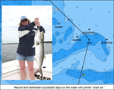
Sort of like repairing or upgrading old instruments, you could also spend some winter off water time getting your waypoints and routes in order. C-Map has put together a nice tip sheet on how you might do that using their chart cards along with the nifty PC Planner product that lets you bring home plotter data and work with it and your C-Map charts on your computer. (To get the PDF, click on the orange card reader here.) You may not be up for making “chart art”, like above, but doesn’t it make sense to sort through the waypoints, tracks, and routes you accumulated last season?
Fisherman especially might want to annotate (like below) and backup those hot spots before the memories fade. Me, I like keeping my tracks as a visual diary (and I’ve had pretty good luck moving them from one format to another). I’ve seen with several plotters I’ve tried recently that C-Map user cards and PC Planner work quite smoothly these days. But I have not tried the most recent edition of Navionics’ NavPlanner, which was a bit cranky in its early days. I also haven’t really tried working on a PC with data from the various new Garmins still in the lab, but I’m pretty sure that there’s no way I can use even the G2 Vision chart cards on a PC, and certainly not the charts build into the units. I think Garmin’s idea is that users can work with their waypoint, etc. data on other map formats, like Google Earth or NOAA raster charts. Has anyone worked out a good system for doing that?


I recommend and use either GPX or KML (Google Earth) format. Most nav apps these days support import/export of both formats. Both are extensible XML.
I know this is somewhat OT, but I was wondering how many waypoints and routes people have and actually use.
For the typical weekend sailor, their range might be 50-60 mile radius and that assumes that most of their weekend is spent underway. A power boat might double this I would assume.
Of course, if you need to navigate a channel to get into open waters, you might have to make a bunch of waypoints (a route) to open water and then you can set off to your chosen destination.
So in the real world, I would seriously like to hear from other sailors and boaters how many waypoints and routes they have, and more importantly actually use (more than once).
I single hand and Seem to have plenty of time to review my charts, plot a paper fix, mess about with 2 chart plotters and still select the next waypoint (except when doing a narrow channel with numerous waypoints which requires being on deck and not watching the show down below on an LCD.
Penobscot Bay and the region would have many more waypoints, routes and options within a more compact range especially considering all the islands and so forth. But that seems to be the exception and not the rule.
So how many waypoints in your library and how many are you using regularly (routes too)?
I use PC Planner extensively. I have 50-60 routes stored in my laptop, each with 10-30 waypoints (some are common between routes). I create new routes as needed, often by using portions of existing routes. Unlike Ben, I do not display or use tracks.
I have been maintaining waypoints and routes over the past 5 years of cruising in Southeast Asia. A common practice among cruisers is to share such information as an aid to planning passages into new areas and areas where chart data is suspect.
I only keep routes that I have confirmed by adjusting waypoints based on a track I have made.
I have 663 waypoints in 110 routes which I maintain in my library. I use the GPSUtility program (www.gpsu.co.uk) to maintain this library. With the ability to capture waypoints and routes from navigation programs and transfer them electronically to just about any GPS on the market the chance for error (which often happens with hand keying) is minimized if not eliminated.
Terry