Adveto advanced AIS presentation, & more

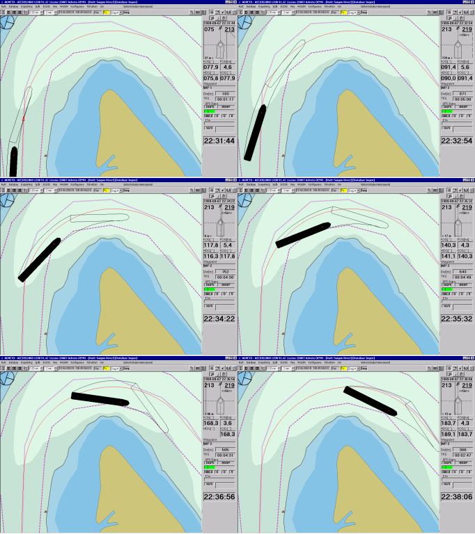
The animation above shows how AIS system data can be used to predict a vessel’s future track, even “bottom sweep”—in this case 2 minutes ahead of its actual position, speed, rate of turn, etc. It’s from AECDIS2000, a commercial grade PC software product developed by a Swedish company called Adveto, which has a long history with AIS. (Check out the interesting illustrations about how radar can misinterpret a target’s turn direction on Adveto’s AIS page). This software was pointed out to me by Fred Pot, who seems to be aware of numerous other AIS possibilites that most of us haven’t heard of yet. For instance, did you know that the system allows vessel traffic service (VTS) operations to transmit “ghost” AIS targets? In other words they can use ARPA radar to track a vessel that’s not AIS equipped—plus perhaps get its name, destination, etc. by VHF—and then send out AIS messages that let other boats in the vicinity “see” it. By the same token, some nations are apparently considering “virtual bouys” as a cost saving move. Instead of all that heavy hardware, an antenna ashore will simply broadcast an AIS message marking the position of the old entrance bouy. On the other hand, some are calling for actual bouys that transmit real time current and weather data. For example, there are critical passes along the inside passage to Alaska where even cruise ships have to wait for near slack current, but the actual time of slack can vary somewhat from the predictions. We’re just beginning to understand where AIS technology will lead.


Yes, the possibilities of AIS are numerous and yet still unknown to most.
Our Yacht-AIS Professional Software is already capabale of displaying such “Ghost AIS Targest” (officially defined by IMO and called “Pseudo AIS Targets) as well as virtual (and real) buoys equipped with AIS. For example, in the Malacca Strait buoys already transmit weather and current data.
“Ghost AIS Targets” contain the following information about a vesel: MMSI, IMO-number or call-sign, Position, COG and SOG.
Holger
if it is possible please send me the french(or english) manual AECDIS-2000V3 VERSION 2003-03-03
Rabhi, contact the manufacturer:
http://www.adveto.com/