Class B, name game #2

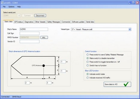
We’re down to Class B AIS details, my friends, and they aren’t hard. Above, and bigger here, is the Static data screen seen in the proAIS software that comes with the European version of Digital Yacht’s AIT250 transponder (and possibly others, as it comes from SRT, the manufacturer of so many Class B circuit boards and finished boxes). In the U.S. market this is the screen an installer would see after he or she had entered the vessel’s MMSI number. Users will see all those data fields grayed out (I presume, as I haven’t actually seen the finished U.S. software). Of course that’s because the FCC barred users from inputing the data themselves. But the user does have to supply accurate info to the installer. Let’s break it down:
* Ship’s name: This must be the name that’s registered with your MMSI at BoatUS, the FCC, or wherever (which should be the same MMSI that’s in your boat’s DSC VHF sets). And presumably the name that’s on your boat. Tim asked (in the first Name Game entry) about prefixes like M/V and S/V, and while they are used by some Class A vessels, the USCG says the name must match the registration. (So I guess if I changed my MMSI registration to M/V Gizmo, that would be OK.) Whatever name you have, it can not exceed 20 characters on a Class B transponder.
* Call Sign: You don’t have one unless your boat has an FCC Station License, though the FCC says a non-licensed vessel can be hailed by its name or state registration number. I thought it might useful to put my Maine registration number in the Call Sign field, but that’s probably not cricket. The field has 7 characters (and, installers take note, if the software requires a Call Sign but the user doesn’t have one, use seven “@” characters, which will end up looking blank in the transponder’s target info).
* Ship’s dimensions: These are expressed in distance from the GPS antenna (and in meters), which is probably why the beams of some Class A vessel’s are wider than the vessel is long! The purpose of this convention is so that your boat’s target will plot properly when zoomed into. It works great when the numbers are right and, people, you can get the numbers right!
* Vessel type: “#37, Vessel – Pleasure Craft”, is the default but there are numerous choices in the drop down menu including “#36, Vessel – Sailing.” The USCG intends to expand the number of vessel types but that will take a while.
There you have it, that’s the static data that you must collect and pass to whoever inputs it into your Class B transponder. If I were installer or a consumer, I’d document it as well as possible—printouts of BoatUS page, copy of FCC license, photo of boat, etc.
Also note on that proAIS screen above that you get to choose if the transponder’s single button sends an SRM (Safety Related Message) or switches to Silent Mode. Hopefully that choice and all the useful tabs shown will be in the U.S. user version of the software. I’d guess that most users will monitor AIS targets on real charting software or on a plotter, or both, but all the Class B software I’ve seen so far has features you might want to get at occasionally. Below is ACR’s Link2AIS, which is similar in many ways to proAIS, in fact they’re interchangeable (same SRT board!). But Link2AIS has a “buddy” feature I really like, bigger here. Click on a vessel that’s important to you, give it a nickname, and whenever that boat enters your AIS field of view again, its target icon will be boldface, and it will go to the top of this target list. The Simrad AI50 has this feature, and I think every AIS plotter should adopt it. You can see that I’ve been using it to distinguish transponders, but obviously Gizmo’s situation today was a little unusual.


I’m curious about the “safety related message”. that is the alternative to a silent mode switch.
What is it, and what advantages does it offer?
Sandy, My impression is that the SRM capability of Class B is a subset of the ship-to-ship or ship-to-all messaging built into Class A. To my knowledge, the latter is not being used very much.
So far, I’ve only seen a couple of plotters or charting programs that know how to notify a user of any AIS text message and display it on screen. In fact, last weekend I accidentally send an SRM with one of the Class B transponders I’m testing. It was received fine by the other B that was running, but I had to dig down in its included software to see it. I think that SRM is a possibly valuable feature built into AIS, but we have a ways to go before it is really usable.
I wonder, do the class B transponders have an NMEA input for compass heading? There is provision for heading in the message specs…
I think the Furuno FA50 does support heading input, but I have not seen any mention of this in other Class B transponders. Do you think it’s important, Richard?
I guess heading is not that important. I was just thinking about improving Memory-Map’s CPA alarm feature for class B, and the heading is there as a potential piece of data. But as there is no input on the SR-based transponders it is probably not worth using it.
Collision detection with class B is actually quite a difficult technical problem. Big ships turn and change speed slowly relative to the position report frequency of a class A AIS. Smaller vessels turn and change speed much faster, while the class B position updates are less frequent. In mathematical terms, the signal is sampled at less than the Nyquist rate, which means it is theoretically impossible to predict the future. The only thing I can do is assume that Gizmo will maneuver like a super-tanker.
It would be interesting to know whether the transponder does any filtering of the vessel’s position, course and speed, or whether it just outputs the latest values from the GPS.
The bottom line, for both developers and users, is that we are going to have to treat CPA predictions for smaller vessels quite differently from those for big ships.
Richard
We can multiplex a heading input into our AIT250 Class B unit. There is an NMEA in as well as a NMEA output. Most users get great results, however, with just the on board calculations of course over ground (COG) from the in built GPS module
Thanks, Nick, I missed that. And I’d guess that if your AIT250 can mix in 0183 heading, maybe all the SRT Class B transponders can.
Personally I can see real value in adding heading for better plotting my own vessel, i.e. being able to compare heading and COG and hence see current set and/or leeway. That is, if my plotter or charting program wasn’t getting such information via another port.
But I don’t think heading info in my AIS broadcasts will make much difference to other vessels and their ability to avoid close encounters with me. And bad heading info can make AIS targets look odd. On the other hand, accurate heading info makes a stopped target plot correctly.
Jim, an owner of a sailboat like mine, is complaining about the alarms on his receiver only AIS unit from Raymarine. It essentially is acting like a proximity alarm, e.g. if your course is going to bring you within a 600 foot circle around any AIS vessel it alarms. It’s annoying now, and he is concerned it gets worse when AIS-B begins to be used.
He is also complaining that AIS-A targets are already cluttering his chartplotter.
Is this just a Raymarine issue, or is that how alarms work ?
The only unwanted, uncontrollable AIS alarms I’ve heard of involve Raymarine MFDs, but I thought they fixed the issue with the last big update.
Where is your friend experiencing AIS clutter and on what display?
I was pretty annoyed by the constant “Dangerous Target” alarms my Raymarine C-80 kept generating, but it turns out the radius of the “danger” circle is configurable, and the alarm can be turned off completely, which is what I’ve done. Dangerous targets still have a flashing outline applied to them on the display, which is great, but I no longer get an audible alarm that requires a manual acknowledgement. Much, much better.
Ben,
Have you heard anything yet about the Coast Guard having the ability to put a “ghost” AIS target in the system to identify vessels in distress. this would help nearby vessels to locate vessels in distress.
Everytime they broadcast LL I don’t seem to have a pencil handy.
Lee
It’s interesting to note that, unless my information is incorrect, coastal ferries are not required to carry AIS. Our home port is in Long Island Sound & we travel up the coast to Maine late summer every year. I installed a Furuno FA150 Class A unit early this year with the main reason being the ferries seem to be getting faster & stealthier every year. There was a collision in July of this year between a ferry, Point Judith to Block Island bound, & a USCG tug, Newport to New London bound, in dense–200yd visibility–fog in Block Island Sound. Reportedly the fog had dropped rather sudden & the CG tug slowed to 9kts while the ferry had maintained its 14.5kt normal cruise. Ferry rammed the tug amidships. (See Professional Mariner Oct/Nov 2008.)
You’re right, John. The Maine State ferries don’t carry AIS either, and they often run in fog. I think there are a number of commercial vessels like these that should have adopted Class A AIS voluntarily. But it’s all going to change when the USCG issues its next round of compulsory AIS carriage. It will take about two years, they estimate, for the rule to be enacted and deadlines met, but 14-17,000 more U.S. commercial vessels will be carrying AIS, either A or B models (apparently the rules will vary).
Lee, I hadn’t heard that idea about marking a distress site, but it makes sense and I believe that it could be fairly easily done, at least by AIS Base Stations.
I do think an effective CPA alarm is very important. For example, it might have prevented the recent collision between the Vendee Globe boat “Hugo Boss” and a fishing boat off Les Sables d’Olonne. http://www.vendeeglobe.org/en/news/5672/Hugo-Boss-dismasts-following-a-collision.html. A lot of accidents happen when people are simply not paying attention.
Many have considered the concept of creating Virtual Aids to Navigation(VATONs )using AIS for a while now.
For example, a USCG AIS Monitoring Station could easily generate a virtual bouy to mark a temporary danger zone or several virtual points to mark oil spill.
Theoretically, virtual bouys could be used everywhere and everyone who has a low cost AIS Receiver could use them for enhanced navigation.
I believe a big consideration is the cost saving aspects of VATONs….
Eric
Ben, Jim sails out of Mystic, Connecticut.
He replied that he has not updated his Raymarine chartplotter. He has has been negative on our Beneteau group about AIS, hopefully the new release will make him a believer.
I just finished installing a Nauticast-B AIS transponder. The display device is a Northstar 557 GPS. On testing, I discovered that the AIS data includes my own ship data as well as the received data. The Northstar GPS apparently was never tested with a transponder because it persists in sounding the proximity alarm because I’m too close to myself. This makes the alarm function completely useless. So far, Northstar won’t even answer my emails on the subject.