
FLIBS, the iPhone effect
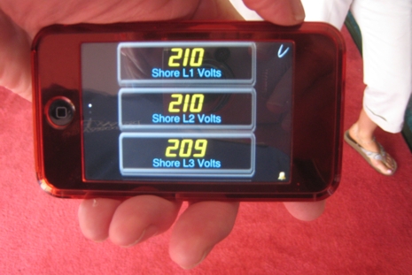
Everywhere I wandered at FLIBS, there was someone fooling with, or showing off, their iPhone. And that includes me, sort of, as I’m now the very enthusiastic owner of an iPod Touch. I’ve always stubbornly resisted the Mac/iPod/Jobs fervor/hype—in fact, this is my first ever Apple product—but, wow, today my propeller beanie is tipped toward Cupertino. Plenty of smart marine developers have also noticed the slick capabilities of the iPhone/Touch apps platform. Being demoed above, for instance, is MySiMON, an extension of Palladium Technology’s megayacht monitoring and control system. The link will give you a sense of how useful this could be to a Touch-toting crew within a yacht’s WiFi network, but picture too an owner able to network with SiMON via iPhone and his yacht’s satellite communications system. So many possibilities…
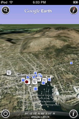
The owner of most any size boat might enjoy iNavX iPhone raster charting or Navionics Mobile worldwide vector charts, which I saw demoed in Fort Lauderdale (they looked good, and I was pleased to hear that there will be a free viewer and inexpensive small area charts in addition to big portfolio licenses). But consider that Google Earth iPhone/Touch just hit the apps store—and quickly became the #1 download—which puts a gleam in the eye of Virgil Zetterlind, developer of the EarthNC marine overlays. Since I last looked, Zetterlind has added a lot of features—like NOAA rasters and advanced weather data—to his various free, subscription, and DVD products, and he showed me a few more in the pipeline, like Wavey Line Bahamas charts and Marinas.com aerial photos. I want to catch up with EarthNC developments now that I, like Virgil, realize that many of them will be coming soon to iWhatevers, Androids, and who knows what else. For instance, those blue icons on the iEarth screen below represent Panoramio user generated photos, of which there are now 8 million, and, um, growing. I recently realized that many new Garmin navigators, like the nifty nüvi 500, work with Garmin Connect to let you download your own or anyone’s Panoramio images into the Garmin. What an amazing sphere we live on.


Ben, great looking apps…any chance you heard developers talking about versions for Blackberry (which sports equally impressive graphics & media capability with their new 3G-based BOLD and STORM devices and millions of users)? I am sure I speak for a lot of boaters who carry these popular devices who would like to employ these cool new services.
Drew
Does the iTouch run the same programs as the iPhone?
Welcome to the Apple revolution Ben!
Yes, the iTouch runs the same software and programs as the iPhone. The only difference is that you need wifi to get online as it doesn’t have a cellular radio.