
Ode to Garmin updating, especially MarineNet 5.0
Lucky me, I have an amazingly bright and progressive plumber who is also a seriously addicted boater, and sometimes we barter our respective skills. Which is how I found myself tuning up and updating his old GPSMap 276C last week. I was amazed to discover that Garmin’s latest update for it was just released on March 19; it’s a minor update, to be sure, but this unit has been around since 2004 (when I gave it a prize). And so I planned an entry complimenting Garmin on its perfectionistic persistence…but that was before I saw the just-released 5.0 software for the networkable 4- and 5000 series. Wow…
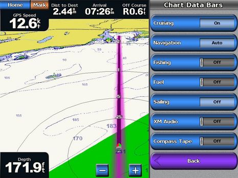
Garmin even has a special web page for the 5.0 update, and has the right to be proud. I’ve only checked it out for an hour or so in the lab, but, nonetheless, spotted a phenomenal number of feature and performance enhancements. In the screen shot below, you can see how the 3D view now very usefully includes spot soundings and bathy lines — even, as shown, with the built-in charts alone, no g2 card in use. Plus you can see how many menus items now include status switches or windows (which were first seen on the 640 and which greatly reduce key punching).
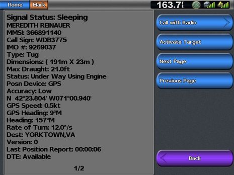
 And how about the AIS target detail screen below. For one thing, there’s the “sleeping” and “active” language that the IMO favors (and I’ll bet IMO target iconagraphy has also been adopted). And, look, there’s the call-target-with-DSC-VHF feature we’ve been pining for here. I plan to do lots more 5.0 testing, but I’m already willing to give Garmin a gold star for constantly improving existing products.


Did Garmin provide a printable hard-copy addendum to the already meager operating manual? Afterall, that may be a significant “upgrade”, but without an addendum, it will do some motivated users little good.
Garmin doesn’t seem to value manuals much any more, and maybe that’s because so few users read them? But they did publish an awesome list of 5.0 changes, which is easiest to access on this THT thread:
http://www.thehulltruth.com/marine-electronics-forum/223325-garmin-5-0-software-4000-5000-series.html
Thomas ……
You should see an online update shortly in regards to the manual. You can access all the new functionalites by placing your unit in the simulation mode. Using the simulation mode you can flex your system and learn all the new functionalities hands on.
Most of these new features will migrate to the 400/500 series in the near future.
The AIS functionality is great. I look for Garmin to release an AIS box in the near future.
Tom
Thanks, Tom. I’ve heard a similar Garmin AIS rumor, though “box” may mean a NMEA 2000 talking receiver, not a full Class B transponder.
I really like what version 5.0 claims about Garmin 4- and 5000 AIS functionality:
# When connected to future Garmin NMEA 2000 VHF radios the user can choose to place a DSC call to any item which has an MMSI number including DSC position markers and AIS vessels on the map.
# Changed the symbols and colors to be closer to international standards.
# AIS vessels are only filtered from the map by distance from the boat. The user can set up the range of interest or choose to show all AIS vessels up to a maximum of 100 vessels.
# Added standard “select and activate” interface for AIS. User can choose which targets to track with a larger symbol and heading/COG indications. All other AIS vessels display in a smaller symbol to minimize clutter.
# Use a solid line for AIS vessel heading and a dashed line for course over ground.
# Added user-controlled trails for AIS, DSC, and MARPA vessels.
What I’m hoping is that these features will work with any manufacturer’s NMEA 2000 Class B transponders and/or VHF radios (if not now, then soon). And I’m planning some experiments to find out 😉
This is a wonderful Garmin upgrade, however, planning a route on the 4000 series using the four-way thumb control is both time consuming and inaccurate for placing route points at a precise spot. This is not a software issue – it’s strictly a mechanical limitation of the control. I would like Garmin to allow route planning on Coastal Explorer 09 with the ability to transfer these routes via SD card to the 4000 or 5000 chartplotter. I can layout a new route and check it for accuracy in minutes on the laptop using CE09. In addition, I can plan new routes on the laptop all winter and move these files to the 4212 in the spring if this feature were added. Getting routes into my waterproof, sunlight readable 4212 in the cockpit would be an outstanding addition to Garmin’s already terrific feature set. Please, please Garmin, add route upload capability via SD card to the software.
Rich C
Richard, Did you notice this on the 5.0 feature list: “Added serial transfer of user data for compatibility with popular PC navigation and planning software.”
I don’t know exactly what it means, but it sounds good. I completely agree with you about the desirability of easy route transfer between CE2009 and Garmin, only I would extend it to tracks and marks (which I like to save as a cruising history/log) and amongst all MFDs and PC charting programs. Heck, handhelds too!
And while we’re at, wouldn’t it be nice if Rose Point added weather buoy data to CE2009’s already nice weather facilities?
Rich …..
In addition to using the thumb button you can enter your waypoints by lat/long if you so desire. Even if you choose to use your pointer to create a route you can go back an edit the route points anytime you want to using lat/long coordinates. You can also use the Garmins Waypoint and Trip Management software.
And yes you will be able to use your CE program to enter data via serial transfer.
[url]http://albums.phanfare.com/4892322/2160001_2325236#imageID=31019463[/url]
Tom
Rats! I just mounted a new VHF, and got it all wired in. Now I have to fill a hole, sell a new radio, get the Garmin N2k radio, cut another hole, and hook it all up, just because I couldn’t wait another WEEK. Rats!
I just upgraded my Garmin GPSMAP 5208 chartplotter this evening to 5.0. There are a lot of very nice UI improvements, but the AIS control is worse so far than before.
I have a Nauticast Class B AIS unit connected to the 5208, and AIS targets appear just fine. However, the alarm control that existed in version 4.80 or newer is gone. All I can find so far is the ability to set the distance and time for when an alarm is set off for AIS.
Before you could disable all alarms for AIS, which is what I prefer.
Now, I get over 50 alarms when I first turn the unit on, and have to dismiss each one. Most of them are close targets that initially show up closer than my 500ft/1m alarm threshold. A number of others are from AIS targets that are no longer available.
Very irritating, but I’m sure there is some way to fix this. I’ll keep searching…
All the rest of the upgrade seems to be pretty positive.
Basically, there is no addendum for a user manual.
Half of my customers aren’t internet savy and are already frustrated that the original manual is poor. I have given up expecting that a top notch company like garmin, expects their ultra friendly software (wink wink) to suffice. That is just expecting too much.
I can’t believe it’s that hard to put these new features to print. The more updates garmin comes up with just make their sw harder and harder. Internet explanations and cute video’s don’t help when the ocean is rough and a feature needs tweeked.
Garmin, are you listening?
There is a brand new revision to the owner’s manuals at the Garmin site. See the link I posted.
http://www8.garmin.com/manuals/3106_4000SeriesOwnersManual.pdf
Thank you very much. I guess I was being heard!
I can’t see a distress button on the remote mic from Garmin. Gee, Joe, say it ain’t so!
In parts of the world where radios are stolen from cockpits, its a good practice to mount them in the cabin and do all your communicating at the helm on a removable (and lock-upable) remote mic, obviously one with a little red covered distress button.
And (sigh) I’m going to miss that numeric keypad on my Standard Horizon VH-310 for MMSI entry. I guess the next thing to dream about is loading a DSC ‘telephone book’ on MapSource software from my home computer to my MFDs.
BUT; Thank you Garmin, for integrating the DSC functions on MFDs and VHF!
Invite us to your next Focus Group!
p.s. I can’t wait to read the novel [the owners’ manuals for both the radio and the mic.]
Sandy, The VHF100/200 manual is up at Garmin, and the GHS 10 remote handset definitely has a DSC Distress Button. It’s on the right side. Sorry!
Garmin has released revision 5.40 there is finally a way to stop self alarming. The realease date says Oct 23rd but I check the site weekly so I don’t know how I missed it. In any case to stop self alarming using my Navionics NL300 Class B transponder install 5.4 then so to configure, then communications, then NMEA2000 where you will see a list off a devices I then scrolled to the Nautico AIS press review and a tab comes up to enter your MMSI. When I 1st brought up the plotters I thought the self alarming was back until I found the AIS MMSI tab under the NMEA2000 Communications tab. It also added �Added a control to turn off the AIS/Marpa Collision Alarm. In addition it fixed the issue where AIS targets with status of moored or anchored were showing up as lost prematurely. It also addressed many GSD22 problems. So far it looks like a nice upgrade. You can read about all the 5.4 updates on the Garmin site.
Bill Lentz
Thanks, Bill. I installed the 5.4 update last week, but didn’t notice the alarm fixes yet. I’ll check out further. 5.4 also adds an Information/UserData selection that lets you copy the whole embedded chart file to a 2gig SD card, which you can then plan on with HomePort. Works slick.