
Jeppesen C-Map app, Plan2Nav previewed

I only got a poor photograph in Miami when Jeppesen let us peek at the soon-to-come C-Map charting app for iPads, and so I’m tickled that they send over a selection of screen shots. While they’re still not saying when the app will be available, I guess we should understand that besides the software itself they’re also tasked with building a system that enables users to buy and download chart regions in what is probably a special format…
At any rate, aren’t the details looking interesting? Like that big (optional) compass rose with “bearing to” pointer, and the ability to rotate the charts (hopefully with “course up” as an option)…

And what looks like lots of underlying data that can be queried — aside from those tide, currents, and harbor photo icons — including sources (something C-Map has always done well, I think)…
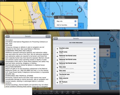
And how about the CWeather forecasts you can slide through with the touch bar at, and a perspective view Jeppesen didn’t even mention in Miami?


Looks interesting, the ipad is quickly becoming a very interesting backup navigation device with apps from Imray, Navionics and now Jeppesen. And affordable too. If only some would create a serious waterproof case 🙂
Very nice Ben, Ive always loved C-map charts.
They are going to need an Android version too to make any headway, as latest figures here, showed Android Tabs and phones, outstripping Ipad/phone over Xmas and NY, by 2:1.It’s the old Betamax versus VHS all over again. Betamax was the best system by far, but as Sony refused to licence it out, they were always going to be the loser, against Matsushita’s VHS which they would licence to any manufacturer, in a similar vein to android. Perhaps the very fact that the Ipad is well locked down, appeals in part to Jeppeson. And until Apple sort themselves out with Adobe, it will long term, lose out I’m sure. But looks great all the same.
Steve
I have put numerous hours on my navionics and think that its great…my only real want is 3d imaging and bottom contouring like the Raymarine E series or the Garmin series. It looks like in the bottom right picture that it is almost in 3D? If so, that will be a huge seller….how much for the app?
Steve, I do think Jeppesen plans an Android edition, but mixing phone and pad sales is quite deceiving. Android is doing very well with phones, but there’s yet to be an Android tablet that even remotely competes with the iPad. And this is a niche where Apple has competitive prices and may be able to maintain them. With 15 million units sold to date, the iPad is no Betamax and Apple has incredible sourcing clout.
BTW, my daughter told me about the scalping gangs that are lined up outside every Apple store in Manhattan. A thriving business has grown up reselling iPad2’s on eBay and or back in China! http://goo.gl/6CpvO
And let’s add here that charting is one of the apps that works much better on a pad than a phone.
Jeppeson will be a welcome addition to iPad charting software. I just regret that Apple doesn’t allow demo versions from the APP store. Perhaps Jeppeson could post a demo on their web page, so we could at least try it out.
I don’t agree with Steve’s suggestion that Android is somehow an alternative. The screen on a phone is just too tiny to be useful for marine charting. If Jeppeson is looking to have something for another platform, they should make a version for the Blackberry Playbook, which RIM says will finally go on sale later this month.
Maybe I’m losing my mind but did something happen to some comments?
I am interested in these charting aps for Ipad. I sail worldwide with paper charts only and it is a pain. I don’t know off hand how many charts but it got to be about 300 lbs worth in three separate chart tables. Half the time I can’t find a chart and have to wait for the second mate to find it for me.
I have been looking for something that will speed up voyage planning for myself. In my search I have found that it is often difficult where reading literature or reviews to determine what areas certain products cover. Several times I’ve spent several minuets reading only to learn that it is only good for NOAA charts. I wish review would state at the beginning if the are worldwide or U.S. coastwise so I wouldn’t waste my time reading review for products I can’t use.
Ben, I’d go out and buy one this afternoon if it had flash with it, but for me without that it’s just another app pony. I know the quality from Foxconn et al. far outstrips anything else on the market, but keep an eye on the Moto Xoom with Honeycomb, looks like android is more on the mark there. I’ll probably get one when they come out here with HSPA later this month. There are a few about but only wi-fi. Meanwhile I’ll stick with my Witstech 7″ MID, which I can tether to the WTC wildfire via wi-fi which gives everything I need (for now). It’ll be interesting to see what happens when HTC enter the tab market properly, as their phones are to die for, especially the Desire HD (Z). Yes you are right, Ipad still reigns the tab market. We could go on for ever, see what happens when geeks go tribal..!!! ?
> And let’s add here that charting is one of the apps that
> works much better on a pad than a phone.
Ben, I know what you mean. And the iPad makes all of these chartplotter apps look better, but I think there’s a much larger discussion here that no one seems to address.
Look at the various threads about using a phone/pad for navigation. Almost no one feels it’s a replacement for a “real” chartplotter yet. Besides the hardware limitations (water, sunlight visibility, etc) the software is immature. Or perhaps there’s something else that’s hard to pinpoint about what’s wrong with it. Your statement that it “works much better on a pad” makes me ask, works better as what?
I’ve used all of these things for quite a few years while underway now. I’ve had my iPad at the helm for just about a full year. It doesn’t replace anything else yet – it provides an additional display, perhaps a good backup. But an additional display showing what? The same chart? Maybe a zoomed out view? I haven’t met anyone yet, myself included, who pilots their boat from their iPad except on a very limited basis.
I think that the rush to create all of these charting products has been done because developers can do it. They can get the various chart data available and provide pictures on the screen along with a GPS overlay showing live position. So now what? How many displays like that do I need to have while underway? This reminds me of the picture I took in 2004 when testing some software at my own helm:
https://www.activecaptain.com/aCappella/helmdisplays.jpg
I know that picture is an exaggeration but there’s an element of sarcasm with it too. Is this helm the helm of the future where every display shows the same thing?
New, accessory, companion types of displays, I believe, have the biggest future for these types of devices onboard. There are no models and no existing products that do this today in a general way for onboard use. I think it’s a fascinating area of development and hope to have some prototypes later in the year showing what can be done on phones, pads, and even TV’s onboard most cruising boats today.
Good point, Jeff, and I have been trying to address it when writing about charting apps…but missed here. So about: “Charting apps work much better on the iPad for planning voyages, sharing tracks, contributing online content, and the other stuff charting apps are good at…not primary navigation!”
Capt. Beck, iNavX may have the largest selection of charts at this point as you can buy all Navionics Gold charts for it via X-Traverse plus cartography from other sources. But I suspect Navionics and the new C-Map app may be the easier way to go for your purposes. I also think that some serious navigators will buy both partly in order to see which has better coverage for which areas.
Transas already has an app but so far offers only U.S. charts. And though I have no inside knowledge of it I’ve got to believe Garmin is going to get into this app thing eventually, and they’ve already got the resources — like a great PC planning app, a mobile weather software service, and complete control of a charts & marine hardware ecosystem — to do it very well.
Rick, I believe the C-Map app will be free with a decent base map, and then users will buy chart regions with the in-app purchase system. So you will get to try the app, and completely if C-Map throws a chart demo area of, say, Miami.
Steve, I’m looking forward to a good Android tablet, too. Remember I’m the guy who said that moving from an iPhone to a Droid felt like getting out of jail! However, I use the iPad a lot now, and it’s definitely not Betamax.
Ben and Jeff:
I for one do use an iPad and iNavX as primary nav. For backup, i have two other GPS. My ten year old Raymarine chartplotter is now only a radar display.
Which gets me to the point of this post. The iPad, and soon to be other tablets including the PlayBook, have resulted in a huge decrease in the cost of a chartplotter, and the free, or nearly free charts that go with them means that there is no reason for anyone to use out of date charts. Sure, the software can be improved (that is why I welcome the new offering from Jeppesen) and the lack of waterproofing might be a problem if you use an iPad in an open cockpit. But lets not loose sight of the paradigm shift that is taking place in navigation hardware and software.
I am not surprised that Jeppesen, and maybe also Garmin are joining the nav App bandwagon. They have seen the future.
I think the situation is quite the opposite, Rick. I believe that Navionics rather brilliantly perceived that the mobile devices were so limited that they could pioneer inexpensive and useful (& fun) chart apps on them without drastically cannibalizing their regular plotter business. C-Map, Transas, etc. have followed.
I can certainly understand wanting to use something besides a 10-year-old chart plotter, but if you’re in U.S. waters I think a much better choice for serious navigation at low cost would be a netbook and an inexpensive PC charting program like CE Express or PolarView (or maybe even GPSnavX, if Apple deigned to make a netbook). They can run rings around any existing iOS or Android charting app while using free NOAA rasters and ENCs. (And CEx will keep them all up to date automatically.)
But you won’t find super cheap Navionics or C-Map for Windows software, and I think that’s because PCs can compete better than mobiles with real navigation devices. Well, actually Navionics does have a PC charting app now, but it’s clearly for planning and also for updating plotter cards. I think we’ll see lots more updating schemes like that as well as plotter sync schemes until eventually MFDs will be going online themselves.
In short, don’t count your paradigm shifts until they hatch 😉
@ruud – A serious waterproof case in the range of 100 $ would have good sales potential. So far no case on the market covers the need of serious sailors.
Marcello, you are on the right path! There is a fantastic mountable and/or removable Ipad case that is designed for the harshest conditions. Should be going to market within a few months. We will keep you posted!!
where is plan2nav !!???!!!
any update on when this is being launched Ben?
I’ve been wondering too, Andy. The app sure looked close to finished back in February but I remember that it took Navionics quite a while to iron the wrinkles out of serving their charts when they switched over to that mode of app…so maybe that’s the issue.
I did just email a query to Jeppesen, but I’ve got to believe that they really want to get the product out the door. I fooled with Navionics’s anytime chart card updating and free PC app and charts with card stuff last week, and it’s all working fairly well. C-Map has some catching up to do.
Just a guess, but the hold up might be the Lodsys patent lawsuit against individual app developers who use the Apple “in app purchase” mechanism. Until that gets sorted out I would think developers would be very hesitant to use that mechanism to sell data (charts) for their apps. Unless of course they want to pay a royalty.
Jeppesen got back to me and said they release their iOS app “by September 2011.”
Big news this morning is that the Jeppesen C-Map Plan2Nav app is now available world wide for iPhones and iPads. The app is free with a good base map, is looking interesting, and at least where I am the weather feature works. Nav app fans, let’s check it out and compare notes next week:
http://itunes.apple.com/us/app/jeppesen-marine-plan2nav/id415917102?ls=1&mt=8