iPad GRIB viewers, Weather4D & WeatherTrack
When I wrote about Garmin’s new GDL 40 cellular weather system recently, the comments reminded me about how many different ways there are to access data and forecasts (and how opinionated some folks are about the methods they favor). So I guess I shouldn’t be surprised when two apps that both specialize in downloading and displaying GRIB weather model data on iPads, or their smaller siblings, take quite different approaches to the task…
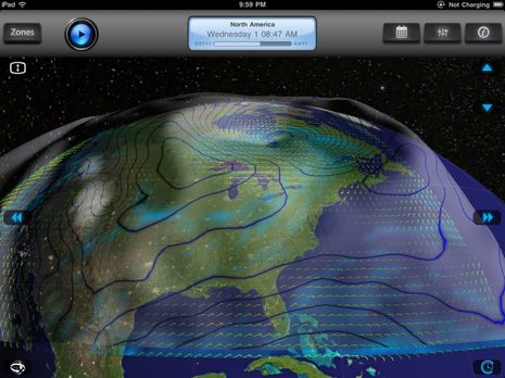
Seen in the top screen is Weather4D, a $6 app that just went into its 1.1 universal edition with all sorts of slick improvements. I think it’s truly earned its multi-dimensional title as it can not only give some 3D contouring to high and low pressure masses but it can animate them smoothly through the time dimension. Watching a deep depression cruise across the Atlantic with, say, wind barbs and precipitation shading also overlaid is a sight to behold. You can almost feel what it’s like for a sailor underneath.
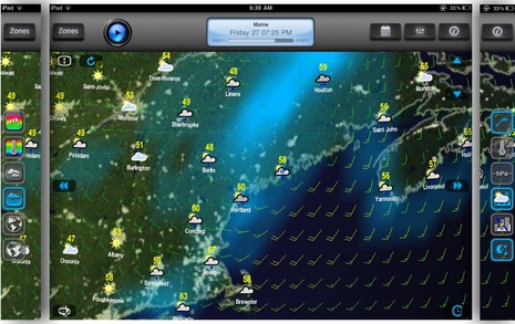
I tend to use GRIB visualizations mainly to understand the big forecast picture, but you can zoom in to more local conditions. On the main Weather4D screen above you just tap on that lower left “Orbiting Mode” icon to pan and zoom around the underlying Google Earth map. Then a tap on the lower right “Time Mode” button lets you swipe through forecast intervals, or you can use the top bar to play the animation, reset to current time, or pick a date off a calendar. A tap on center screen brings up the overlay icons — with active layers outlined in blue — that I’ve cut and pasted to each side of the image.
Note, for instance, the moon/stars “show night” icon, which is why it was getting dark in Nova Scotia Friday evening at 7:25 EDT. And when you are zoomed out as in the top screen, the Milky Way spins appropriately through the heavens. There’s much more to Weather4D but suffice it to say that I don’t know of a weather app that takes advantage of an iPad’s speedy touch screen so well.
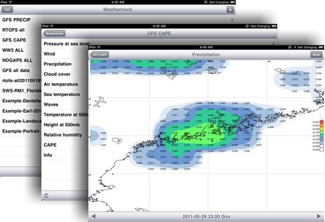
But the data Weather4D displays seems rather paltry once you’ve had a taste of WeatherTrack, “The Swiss Army Knife for Weather Enthusiasts!”, which costs $20. Sure, both apps let you define custom download zones and control the forecast resolution, time interval, and data types in order manage the download sizes, but Weather4D currently only supports the five main data types generated by NOAA’s GFS model. The left hand WeatherTrack screen below suggests all the models I’ve set up views of, and the middle screen shows all the GFS data points that can be downloaded…
Actually a couple of those data types, like Relative Humidity and CAPE, won’t be available until WeatherTrack 1.2 ships in a few days (I recently got a Beta version). CAPE, incidentally, stands for Convective Available Potential Energy, said to be a good predictor of severe weather, but I suspect you’re getting the idea. In general, the WeatherTrack developer has put his energy into data versatility while the 4D guy went more for display and interface. One exception I notice, though, is the presentation of GFS precipitation forecasts. You can see it above depicted as a somewhat vague blue overlay in 4D and more like multi-color NEXRAD radar in WeatherTrack. (By the way, the Friday night showers predicted that morning stayed north of Camden while — to my amazement — the Sunday evening rain cell predicted Saturday morning did actually nail us, though a few hours later and with more intensity.)
But WeatherTrack does not let you mix data type overlays on a single map screen like 4D (and many other Web and PC GRIB viewers I’ve seen). I find that a real shortcoming as it seems to help me understand what’s going on to see, say, pressure, wind, and precip inter-relate over a forecast period. On the other hand, WeatherTrack largely makes up for this with its neat meteogram feature. Tap on a location of interest and you can immediately go to a screen like the one below that graphs all of a file’s data for that point over time…
And I don’t think there’s another app out there that can access the RTOFS model of Atlantic Ocean currents and surface temps, even if you can only view one value at a time. (The hot colors below map current speeds, even if they do correspond somewhat to the hot temps of the Gulf Stream.)…
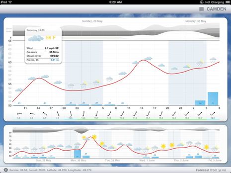
So I’m liking both these apps a lot, and will be curious to watch their evolutions. Of course, I’d like to hear what you think of them, or alternative forecast viewers. And if GRIBs aren’t your thing but you do have an iPad, you might enjoy Meteogram. It certainly can’t display all the data WeatherTrack’s meteogram can, but it’s only $2, operating it is simple, and the screen design is gorgeous, I think. Note, for instance how three layers of forecast cloud cover are depicted. Note too how the sun and warm air finally arrived in Camden yesterday — after weeks when summer boating seemed like it might never happen — which is one of my excuses for neglecting Panbo a bit 😉







Nice PS: The developer of Weather4D is offering free redeem codes to the first 20 Panbo readers who send an email to this address:
[email protected]
Panbo and MTA would appreciate it if those twenty lucky folks also commit to taking the marine electronics survey:
https://www.surveymonkey.com/s/ZYPFC2W
Hey I won something!
Thanks to the developer and to Mr Ellison. Unfortunately (and with a slight amount of guilt) I’m not a current boat owner. However I’m a commercial pilot so until we find our next boat I’ll put the app to good use.
Thanks again.
Wow, that was fast; all the Weather4D redeem codes were spoken for about an hour ago. But there is a “Panbo Event” running for 24 hours that will get you Weather4D for half price.
Also WeatherTrack is joining the fun with its own redeem code giveaway. Email this address, but don’t be slow:
[email protected]
Wonderful that you have spotted and are reporting on what I think are some of the most interesting and important new mobile apps for the boating community, THANKS !
A great article would be one covering what apps are available on iOS Vs. Android… bit of a mobile OS smackdown.
-p
Ben, thanks for taking the time to review WEATHERTRACK.
Just a quick comment on the WEATHERTRACK RTOFS data, there are multiple layers in this forecast model, and current (direction and strength) is only one of them. You can also request water temperature and salinity for example. In the water temperature layer you see the colorization according to temperature.
By the way, CAPE and the other new features are submitted to the app store and should be available in a few days. For those who can not wait, you can get a quick glance here: http://www.weathertrack.us/cape
Thank you, Jens, and let’s note that the redeem codes WeatherTrack offered this morning are also all gone. Hopefully, those readers will come back here soon with their opinions of these two products.
Ben,
We have been using iGrib for a little while and like it as an app but we are always on the lookout for other good software for the iPad.
Ed and Sue on s/v Angel Louise, lying Bermuda waiting for weather
http://tinyurl.com/edandsue
Ben, is the resolution of these products similiar? (e.g. x miles). Is the data massaged by proprietary algorithms to generate a higher resolution result than the original source? Are the results in any way between the two products ?
Take the earlier question in context of a product like WeatherCaster that applied their own algorithms to generate higher resolution results than the raw data. Is something similiar going on here in addition to the unique presentation being provided?
Anyone know the possibilities of connecting the iPad to Iridium? Then it could access WeatherNet or MailASail and no laptop is needed onboard for longhauls.
Grib files are ok… but most GRIB files I’ve seen do not have the critical features needed for pro-level forecasting (500MB Chart & detailed pressure system overviews) which is why I’m sticking with WeatherFax via a Furuno Fax30.
But weather fax’s are flat and boring which is why I really like the Navy’s NOGAPS files which contain most of the data I need. So I’m very excited to see NOGAPS listed in your screenshot of WeatherTracks!! I’ll be testing this as soon as I get an iPad.
Of note there are two apps that I’ve seen – but not tested – for viewing WeatherFax on an iPad. The first, HF Weather Fax by Black Cat Systems, requires you to prop your iPad next to an SSB receiver during broadcast times (which I’m not about to do) but the other, marineweatherfaxviewer.com, seems to download the data via the internet.
If anyone tests the WeatherFax apps… please let me know your thoughts!
John, 500mb GRIBs are available, at least via saildocs.
John, Please check out those WeatherTrack screens above, and the app itself, a little deeper. 500MB pressure, and even temperature, is available, perhaps from more than one model.
What’s not in any GRIB files I’ve seen, though, are the frontal lines and system motion predictions that meteorologists draw onto weatherfaxes…and I miss those a lot. So I too would like to hear about fax apps, even if it’s a crude way to communicate info in the digital age.
Hello, I would like to inform that GRID data (google maps + layers) will be available on the Meteogram iPad application, I’m implementing it now.
Kind Regards,
Michal
Hmm looks good. I have been hanging off buying an ipad for a while now- these could be the apps that turn the trick (now if I can just somehow ‘weatherproof’ it so I can use one in the cockpit -I know that waterproofing is probably impossible)…..
Dan, It’s actually pretty easy to waterproof an iPad because no wires need be involved, even for long periods of use since the battery is quite good. But seeing one well in bright sunshine is a problem. At any rate here are some reviews of boat worthy iPad cases I’ve tried: http://goo.gl/0sWsh
Here’s further info on the iGrib app Ed Kelly mentioned:
http://www.mojoso.co.uk/igrib/
iGrib looks pretty basic at this point — especially compared to Weather4D or WeatherTrack — but the developer also has an interesting UK-centered tide, weather, & whatnot app called Boatie.
What a great app Weather4D is. I didn’t realize that there were these kinds of apps out there. It runs very smoothly with no glitches that I’ve experienced and the visual presentation is extrememly nice. Seems to me that this would be a great addition to the weather toolbag. I’ll bet it would really shine (as well as the other apps mentioned) on an iPad.
Re waterproof cases, there is a company called Lifeproof that has just begun to ship waterproof cases for the iPhone. Their claims re the case seem very impressive. They also intend to sell a case for the iPad. (Not affiliated BTW)
Lifeproof.com if interested and my apologies to Mr. Ellison if he’s already mentioned them.
I would like to comment on Dan Corcoran (b393capt)’s issue about the resolution. WEATHERTRACK (I can’t speak for Weather4D) does use interpolation to smooth the edges (make the display less blocky). This interpolation can be turned off in the settings if you really want to see the GRIB file’s native resolution properly represented visually.
Otherwise the resolution depends on weather model and provider, GFS is at most 0.5 degrees. There are commercial weather subscriptions with higher resolution GRIB data, and WEATHERTRACK will display these finer resolutions. For example you can open email attachments (including zip files) or the web browser on the mobile device.
Thanks for the overview, John, but please call me Ben.
Thanks also for the LifeProof reference. It’s a brand new company with a very interesting everything-proof iPhone4 case. The iPad case looks good, too, but I doubt there will be a model for the original pad or if there will be a way to secure the case to a mount (which a lot of boaters want, I think).
http://www.lifeproof.com/lifeproof-store/apple-cases/ipad
WEATHERTRACK !!!!
I’m as excited as a kid in a candy store, great GRIB on the iPhone has been a long time coming. iNavX does it but I am not overwhelmed with the iNavX implementation, external account required and extra button steps to recover and download requested file.
WeatherTrack is AWESOME .
. . . . . my suggestions:
The meteogram works well but, . . . on the iPhone I can’t view multiple parameters for the full multi-day time span, so as to get a ‘view from a distance’ of what will be happening with, for example, wind, pressure, and perception over a several day period.
Parameter entry could use a bit of tuning with grid-spacing and number-days making you pick a number from the air rather than presenting the truly available options. More in line with my preference is the parameter ‘interval’ which takes you to a selection screen where you pick either 3,6,12,or 24 hours, which is what I am used to.
I am really excited by this app and look forward using it for trip planning and maybe even seeing great additions and refinements to it.
****************
Iridium sat phone interface is coming soon I hope.
Just purchased Weather 4D. What a valuable app. I feel like a real meteorologist. Plus it is really designed for an iPad. The resolution is terrific. Great UI and easy learning curve.
CAPE and other new features are available now, since WEATHERTRACK 1.2 has been released in the app store a couple of hours ago.
PocketGrib is another iOS GRIB viewer I missed, and it’s pretty darn good. It’s even got CAPE: http://goo.gl/6NTia
Also YouTube video demo here: http://www.youtube.com/watch?v=wJrX4u0i5a4
Plus if the first 20 people to email the developer will get a redeem code:
[email protected]
Remember to tell us what you think, please.
I found these GRIB viewers very useful this morning for visualizing the predicted winds in the track of hurricane Irene. They’ve all improved, but Weather4D remains the leader in terms of graphic excellence while Weathertrack is still the only viewer that let’s you check out weather models other than GFS. PocketGrib is fairly simple and inexpensive like 4D but has the valuable meteogram view.
I was pleased to see that Irene has lost a bit of her mojo, but am making plans to safeguard Gizmo. Good luck to everyone along the track.
Thank you for mentioning this.There seems to be a misunderstanding. WEATHERTRACK does have a very valuable meteogram view as well (according to our users, see http://www.weathertrack.us/reviews). You can tap on any place on the forecast map to get a meteogram for that particular latitude/longitude. In addition the meteogram feature is even flexible and dynamic, so you can see any layer displayed in the meteogram, no matter if it is height at 500mb or current or salinity.
And there are more differences. WEATHERTRACK does not need an internet connection to function well. WEATHERTRACK works offline. The app does not use a google map which cannot be displayed offline, but offers a specifically designed worldwide offline map. Users do not need internet to display the map or use any other features. GRIB files can be downloaded through a SSB connection and transmitted via iTunes to your iPhone/iPad/iPod touch or PC and viewed offshore. You can also choose to open GRIB file attachments from email messages in WEATHERTRACK. This gives access to specialized weather forecasts, for example higher resolution data available from commercial subscription based services.
Maybe I didn’t express myself well, Jens. Of course Weathertrack has a meteogram; it’s illustrated above. It’s Weather4D that lacks this view of the data.
WEATHERTRACK 1.3 released a couple of days ago. We listened to our users and improved graphics and the map which works perfectly offline. Online: many new features available, including weather forecasts thru fax, satellite and radar.
Hello,
The ballet of the North Atlantic depressions seen by the future release (v1.2) of Weather4D:
http://vimeo.com/28817963
(Output from Weather4D on iPad with 0.5° GFS & 1° FNMOC WW3 models)
For your information I will be present at the stand of iPadNav to present this new release at the Grand Pavois from La Rochelle (France)
http://www.ipadnav.fr/lang-en/
Best, Olivier Bouyssou
I am pleased to announce the availability of the new release of Weather4D : v1.2.
New features (CAPE, waves etc…) : http://www.weather4d.com/en/news
King Regards,
Olivier Bouyssou
I have tried the new version and its awesome!!!
I did a review of the available apps you might to check out: http://deepplaya.com/?p=647
With the addition of wave models, Weather 4D HD is now my favorite.
Congrats Oliver, you’ve got it out first. I’ve been working on this and other projects, too. Will follow shortly!
I always click the wrong link in the email…
Jens-Uwe,
thank, I long to see that!
Weather4d: 4 crashes in ten minutes! These are 4 crashes too much. Just bought it. It is all about show and design, not functionaliy. Zoom-in feature is very limited, not practcal at all, not detailed seletion possible. High expectations,very disappointed. Not worth the money.
4 crashes in 10 minutes is not normal! The problem must come from elsewhere. There are a few thousand users of W4D and they did not reported this problem.
Have you tried restarting your iPhone or your iPad? Feel free to contact me by mail, I could maybe help you to find the source of your problem.
I have deliberately limited the zoom to stay in the area of use of the GFS model. This model has its data on a grid of 0.5 °. On our latitude that is about one point every 50 km. More zoom would amount to an interpolation of data between the grid points and in my opinion would give a false sense of precision. In addition W4D not intended to be mapping software.
Hope this helps.
What version of device and how much storage di you have, we fund almost no apps that are larger or use the GPS work at all (including the builtin maps app) on our iPhone 3G since the iOS 4 upgrade. but the iPhone 4 and iPad 2 work great.
Hello,
I am pleased to announce the availability of Pro verion of Weather4D.
A summary of new features:
– Prediction passage of the Iridium satellites constellation.
I added in Weather4D Pro the display of the Iridium constellation on the globe in 3D and I implemented a function for predict passage of satellites and a search function for find an appointment and retrieve his GRIB files in conditions of optimum reception.
A search button calculates a date based on criteria defined in the “Options prediction” of “Settings”. Two criteria are available:
– Minimum elevation (angle mini above the horizon)
– Minimum time range (minimum time of exposure for the elevation choose)
– The import of GRIB file:
The application accepts files Grib type 1 and recognizes the .rgb file and grb.gz,. Grb.bz2 for compressed versions. From mail, Safari or any other applications using the mechanism “Open In” you can import files in GRIB Weather4D Pro. Imported files are stored in a folder reserved for them.
– Historical of GRIB files:
So far, the refresh of weather data from an zone overwrite old data. Now the application maintains a history for each zone. The history files are stored in a folder that you can view at your leisure.
– Personal Folder File GRIB:
You can always make a copy of a file Grib from an zone to a personal folder (My GRIB) and store them in a tree. You can also create folders and subfolders to organize your GRIB.
– Copy / Paste GRIB file:
Through this mechanism you copy files between folders (Historical, File Import and in “My Gribs”).
– Share your files GRIB:
Grib files can be sent by attachment in an email or exported to a compatible application (iNavX, File Connect etc …) via a menu “Open In”
– SailDocs request by Mail:
To use Weather4D Pro in a satellite communication or BLU environment you can create a SailDocs request from a zone. The contents of the mail is automatically generated based on settings of the zone. Thereafter you choose your email client. Choose from: Mail, and XGate AxcessPoint…
– Importing KML file type to see the movement of the vessel during weather forecasts.
These files can be created by any other navigation applications like iNavX.
Back on land after 14 days of sailing between Las Palmas and St. Lucia, here’s an article that summarizes our use of AxcessPoint during our crossing of the Atlantic:
http://blog.francis-fustier.fr/en/navigation-sur-ipad-la-solution-integrale/
44 connections, 22 grib files, 0 failure…
Thanks, Olivier. The Pro version sounds interesting. What will be the price and do I gather that iOS 5 is necessary?
And the blog entry is a great read. I love the thought of you working on WeatherHD as you sailed transatlantic and simultaneously tested Iridium AxcessPoint. And Francis Fustier was apparently along to document. Hats off to all, and I’m adding his “Navigation Mac” to Panbo’s blogroll “toot sweet” (as we say here 😉
http://blog.francis-fustier.fr/en/
Ben,
In fact I made a mistake on the beta version that I sent you. I have started adding iCloud but I think I’ll abandon that idea for now. I’ll fix that …
The version available on the App Store requires an IOS version >= 4.3 for a price of $30.99
Awesome job Olivier. I love the ability to get my SSB fetched gribs into the app!
Thanks a lot!
-p
Patrick,
Yes, I have not tried yet, it should be possible with Airmail by activating the pop/smtp module.
— Olivier (Callsign: F1NXH)
I was going to do it by copying he file to the iPhone… Once that is done, I should be able to open it your App.
Since December 6th WeatherTrack is on Xmas sale with a huge price drop of 50%, decreasing from 19.99 USD to only 9.99 USD!
Now is a good time to buy and try, as the next release 1.4, is coming very soon with new great features.
Seasons greetings
Hello,
I am pleased to announce the availabilty of version 1.1 of Weather4D Pro:
New features:
– Improving the readability of the info window
– Displays coordinates in the info window
– Displays the speed and course (SOG, COG) in the info window
– Display time period of the GRIB files
– Select the start waypoint of a route
– Selecting a route based on an estimated speed and heading. Optionally, the source of the course and speed can be manually or based on GPS data.
– Ability to import a GRIB in an zone if the parameters match.
– Dynamics meteogram on the target, along a road (kml imported) or the estimated route. It appears by tapping on the window info. On IPhone you choose your parameter by a long tap on the meteogram.
– Display of cursors start and finish on the meteogram
– Various fixes
Best,
Olivier Bouyssou
http://www.weather4d.com/en
Here is a link to another article detailing the use of Weather4D Pro with an Iridium AxcessPoint:
http://blog.francis-fustier.fr/en/iridium-axcesspoint-les-fichiers-meteo-grib-sur-ipad-et-iphone-au-grand-large/
It has been a while since the last update. But when you see the WeatherTrack’s latest
version, you will probably understand why: amazing ideas, new features and many improvements. For instance:
– GLOBAL-LOCAL, a stunning eye-catcher:
A fascinating look from space showing a world map with the current satellite cloud images overlayed (clouds update about every three hours, daylight area is calculated every 10 minutes). Day-night shadow is not an image, but the shadow respectively the sun position is calculated by WeatherTrack. The Global-Local feature is quite useful as you can see the global systems and how they move around on Earth. Additionally you can tap on the map and see a bubble pop up with a local eight-day forecast at this position. These bubbles are remembered, so you will see the weather in your favorite places all around the world every time WeatherTrack launches.
– WeatherTrack also offers a new model to display the waves in the Mediterranean, with a high resolution of 0.05 degrees . It is available on a 0.05 grid (lat/lon) displaying a forecast every hour up to 4 days. The model is calculated three times a day (13UTC, 17UTC and 21 UTC). Available data layers include significant wave height and directions and swell height and direction.)
For more information, please see here: http://itunes.apple.com/us/app/weathertrack/id417401887?mt=8&ls=1
Routing comes up in Weather4D PRO 1.3 !
More information here:
http://blog.francis-fustier.fr/en/le-routage-arrive-dans-weather4d-pro-1-3/
Hello,
The v1.3.0 release of Weather4D Pro is available on App Store:
News:
– Compatibility iOS 6.
– Compatibility iPhone 5.
– Isochronous routing (sailing and motor).
– Import of polar from csv file.
– Management of polar combined with multiple sets sail.
– Mail request by Great Circle (Mail, XGate, AxcessPoint).
– Management of a route from your current location.
–Olivier Bouyssou
WeatherTrack v1.4.7
As requested by users: an hourly forecast in high 0.25 degree resolution for waves (in the North Atlantic and North Pacific, seasonal) has been added with version 1.4.7 (available on the App store since September 21st)
Navigation Mac has a complete review of Weather 4D’s routing capabilities — http://goo.gl/j5NMo — which seem pretty amazing.
iNavX now supports Theyr High Resolution Weather (via X-Traverse) ..
http://www.macsailing.net/fbb/showtopic.php?tid/2256/
Soon to calculate your polar:
http://blog.francis-fustier.fr/en/ipolar-genere-des-polaires-pour-weather4d-pro/
Sounds really interesting, Olivier! Readers may be interested to know that there’s another iOS app that can can calculate polares, SailTimer:
http://www.sailtimerapp.com/
It does not do weather routing using the polars but it can calculate optimal tacks and ETA to a waypoint when tacking (also known as TTD, Tacking Time to Destination). Dan Corcoran has been testing the SailTime app as well as SailTimer hardware and hopefully will report soon.
Hello,
Weather4D Pro 1.3.3 is available on the App Store.
More about it:
http://blog.francis-fustier.fr/en/weather4d-pro-1-3-3-ameliore-encore-le-routage/
I forgot, a video about new features:
https://vimeo.com/59562648
That video with the smart routing based on wind f’casts and boat polars is pretty impressive.
Looks like all of the B&G Zeus stuff I just bought with GRIB and tack planning is rather primitive by comparison!
https://vimeo.com/59562648
Dead on time for the coming up sailing season, WeatherTrack offers another cool tool: ROUTE WEATHER. Following the requests of many users now it is possible to plot (or import/export) a route and download a GRIB forecast along the entire route. WeatherTrack displays a Route Meteogram. Enter the estimated speed and select wind mode (true, relative, apparent). View all GRIB data at once, including information for each waypoint: distance, duration to next waypoint, bearing, fuel consumption.
Route Weather at a glance:
http://youtu.be/HXISDc87IQk
WeatherTrack supports GPX KML KMZ files.
Share the complete route file via email or open in your favorite navigation app.
Available now.
New release of Weather4D (1.3.0):
– Vector shoreline
– Dynamic meteogram on target: It appears by a tap on the info window. On iPhone you choose your weather parameter by a long tap on the meteogram
– GCWF Models available with 96h horizon and refreshed every 6 hours
– Added GEM 0.24° Model from CMC
– Added COAMPS 0.20° models (Europe, Central America, West Atlantic and North East Pacific) from FNMOC
– New currents models from My Ocean available without subscription
For your information: 50% off on Weather4D Pro during 24 hours !
https://itunes.apple.com/fr/app/weather4d-pro/id480096611?mt=8
Hello,
I am pleased to announce the availabilty of Weather4D for Android:
https://play.google.com/store/apps/details?id=com.app4nav.android.weather4d&hl=fr
Thank you all for your support and great feedback.
We are pleased to announce the release of version 1.5.5 Since today WeatherTrack offers another great feature: GRIB robot.
Most apps can only handle one file at a time per email request when using satellite communication. With one single email WeatherTrack’s new feature GRIB Robot can handle multiple requests which are merged into one single file.
Please find more information here:
http://www.weathertrack.us/robot.html
And now W4D on Kindles…:
http://www.amazon.com/gp/product/B00GWEU2QK
Cool. SailGrib, an Android weather app, just showed up in the Panbo Classifieds:
https://panbo.com/classifieds/viewlisting.php?view=184
There’s also a version that does routing, and free versions of both, which I’m going to try 😉
Anyone tried the Weather 4D Pro app with weather routing? Go or no go? $23.99. Worth trying? I’m particularly (only) interested in the weather routing function.
Though I don’t remember paying that much for it, I really like Weather 4D Pro on the iPad. It’s visualization of the weather forecast is great. We use it all the time as full time cruisers. I typically don’t use the routing function to choose a route for us, but I do use it to show the weather forecast changing with our forecast position along our route.
Pros:
– great visualization
– can download Gribs to it via email (we use the satphone on passages for this)
– can use a polar file for the boat
– supports routing
– includes a function that shows you the location of all the iridium satellites in real time (very helpful in deciding when to try and pick up data)
Cons:
– you have to create routes in another app (eg iNavx) and then import them
New Release (1.1-72) for Android:
– Added GFS Model 0.25 ° / 10 Days
– Adding maps: SHOM (France), UKHO (United Kingdom), ASH (Australia), BSH (Germany), NHS (Argentina), NLHO (Netherlands)
– Ability to independently manage each screen position and zoom level.
– Prediction Vector
– Heading Line
– Navigation data
– Navigation functions: Goto and Route
– NMEA183 in TCP and UDP mode
– Location by the Internal GPS or NMEA
– Sending commands to the NMEA Autopilot
– NMEA 183 Integrated Simulator
– Low energy mode
Here a video link (in French) about this release:
http://youtu.be/76wy5dBSqSI
Several new Weather4D releases came out recently.
– Weather4D Lite
100% weather application to visualize weather and ocean GRIB files in an even more sophisticated HD 3D interface featuring over 35 models.
– Weather4D Routing
Adds routing to the equation just like the former Pro version used to do. It is perfect for boaters who already have a navigation application capable of importing/exporting routes such as iNavX or iSailor.
– Weather4D Routing & Navigation
This is the integration combining weather and ocean GRIB files, routing, real time navigation data with nautical charts, AIS, track record/import/export, night mode, alarms, bluetooth connectivity.
– Weather4D Lite Upgrade to Weather4D Routing & Navigation
This bundle is for Weather4D Lite users hitching to get the full Weather4D experience.
– Weather4D Routing Upgrade to Weather 4D Routing & Navigation
This bundle is for Weather4D Routing users who are also ready to get the full Weather4D experience.
– iWatchSat
iWatchSat tells when a satellite is easily reachable with Iridium. This feature is well known by Weather4D Pro users who recently upgraded to Weather4D Routing and Weather4D Routing & Navigation. It’s now available as a free stand alone app.
Visit https://www.weather4d.com/comparison-table to see the full feature list
or https://itunes.apple.com/us/developer/olivier-bouyssou/id418723848 to take a look at the products list