
Garmin GDL 40, cellular weather & maybe much more
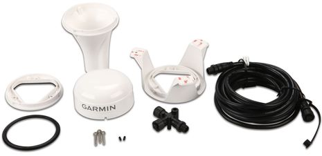
Yes, the hardware kit looks just like a Garmin 17x GPS or GXM 51 Satellite Weather rig — what with three different install options, under deck included, and an N2K cable and tee for power and data — but in fact it’s the company’s brand new GDL 40 Cellular Marine Weather Receiver, just announced today and shipping in June. I think it will be an attractive new integrated weather option because the hardware is reasonable at $300 retail and you only pay for the weather data — available to start along the coasts of the U.S., Canada or Europe — when you use it. But when you think about what other services could be provided by a two-way GSM cellular modem networked to your boat’s NMEA 2000 network and (Garmin) MFDs, I think you’ll agree that this may be one of the most important product advances of the year…
Let’s discuss Garmin’s marine weather service first. Judging from the various screens seen below it looks a lot like the XM Satellite Weather that Garmin pioneered on handhelds and then on multifunction displays. But, in fact, the data is provided by a Garmin subsidiary called Digital Cyclone, which already produces all sorts of weather services for cell phones, plus app phones and pads.
Now I’m sure the first thought of many is “Why would I need a dedicated weather service if it only works within cell range where I can already use my iPad (or whatever) to access all sorts of weather for free?” That will no doubt be true for many cruisers (and, incidentally, I’ve been testing some neat iPad weather apps that I’ll write about soon). But there are many boats on which the MFD is the biggest, brightest screen available…
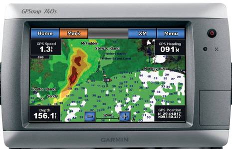
And besides Garmin has gotten quite good at showing weather on its MFDs. I tested the XM satellite service again last summer, on both a 7212 and a 740, and I was impressed by how the well they’ve evolved the controls for mixing and viewing the data. And of course when you’re underway, especially with thunder storms around, the helm is where you want nearly live NEXRAD radar and lightning strike data. Actually, I think all the major MFDs can display XM or Sirius weather data pretty well these days, judging from various demos I’ve been on. The problem for a lot of people, myself included, is the cost and obligation…

I don’t know why satellite weather receivers all seem to be in the $600 to $900 range, but they are, and many involve a fair bit of installation. Especially compared to the GDL 40 with all those mount options and a dead simple N2K connection for data and power. (It’s worth noting that you can plug an external cellular antenna into the bottom of the GDL for extended range, but it’s purely optional.) And then there are the data subscriptions; for XM it’s $50 a month to get what you really want, while Sirius inexplicably has two rates, $30 and $60, for full data packages. And “activation fees may apply” if you don’t want to pay for weather data during months you’re not using it!
Garmin has a very different approach. GDL 40 users will pay a $10 a year activation fee, which will involve registering a charge card on a Garmin site that will then be tapped $5 whenever you tell your Garmin MFD that you want a day of weather data. I understand that there may be different fees outside the U.S. and also additional charges if your cellular connection roams. I don’t know the details yet but do know that you can turn off roaming to avoid surprises. I’m also pretty sure that Garmin’s cellular partner is AT&T…

I think it’s AT&T because that’s what the coverage map indicates for Garmin’s new GTU 10 GPS tracker. The tracker might actually be useful for marine assets like tenders, but I’ve been looking at it because it seems like the service it provides could be added to the GDL 40 very easily. It would take very little cellular bandwidth to let your friends and family see exactly where your boat is. Or to put a geofence around it when you’re ashore. But, heck, since the GDL is on the N2K backbone couldn’t it also send battery condition, refrigerator temperature, entry alarms…lots of stuff if you have the sensors? I think the answer is “Yes, easily!” and that there are all sorts of other ways the connection could be used. Garmin chart updating? Text messages on your Garmin MFD?
Garmin won’t say what services might get added to the GDL 40, if any — they’re very careful that way — but I believe that they consider it a big deal and I know they’ve been working it on for a long time. So let’s help them do some market research about future possibilities. What services would you like to see served over GSM cellular to and from your boat’s NMEA 2000 network?


Perhaps some small portion of this https://panbo.com/archives/2011/04/ultimate_open_mfd_or_ethernet_monstrosity.html is a possibility.
With cellular capability added to the MFD and Android emulators becoming available for various operating systems, perhaps one day Garmin owners can open a window in their MFD, choose the Android Marketplace, download marine applications that are begging for a sunlight viewable screen, and run them right on the MFD. How cool would that be!
Then there are all those other Android applications to choose from. Webex would be interesting. Perhaps Garmin owners could attend web conference meetings while fishing?
Dan, I don’t know for sure, but I suspect that the GDL 40 is a GPRS/EDGE modem, not 3G or Mobile Broadband as AT&T calls it.
Also, I think I’m going to be testing one of these very soon 😉
When we answer your question about future possibilities, I guess we have some constraints, for example there is only so much bandwidth over NMEA-2000 between the GDL 40 and the MFD. (webex while fishing won’t be happening)
Ben, I suppose NMEA hasn’t formed a committee or a standard for cellular data over NMEA-2000 yet. Which brings to mind:
– Has Garmin said if the GDL 40 is an exclusive accessory to their MFD’s, or is the weather and other future uses open to other NMEA-2000 components?
– Does the GDL 40 support multiple 2-way connections to devices over NMEA-2000 simulatenously ?
– Is there a utility to connect the weather data to a PC for purposes of obtaining standard GRIB weather files, or a way to obtain GRIB files via the MFD (memory card transfer ?)
– Has Garmin stated how much bandwidth the weather data consumes on the NMEA-2000 bus ?
Being an MFD, I would imagine cartography was on their mind when they designed this, so I would expect next up could be:
– cartography updates over cellular
– POI – Access to ActiveCaptain ? Fuel prices at each dock ?
– Precision location information on all bouy’s ?
– For Garmin MFD’s not connected to an AIS, receive AIS information for fixed objects, or maybe a full blown AIS proxy?
– MOB Alerts transmitted via cellular to other Garmin MFD equipped boats, or maybe even the USCG ?
I’m a bit puzzled. I come up with $1825/year for delivering repackaged data that is essentially free, with a $300 cost of entry.
My unlimited (in volume and type) data plan with my GSM phone does the same thing for $360/year (on a more robust network when away from cities), with a $100 cost of entry.
While the Garmin technical solution looks pretty elegant, I don’t understand how they came up with this price point.
It seems to me a phone tethered to a laptop, or a GSM tablet both provide both provide a better economic solution. The only thing missing is NMEA 2000 from phone or laptop or tablet to MFD.
For $1 a day or if I only wanted weather (and future etc) for 73 or fewer days a year this would look good. At this price point for daily usage, not so much.
You may be over complicating things, Dan 😉
Maybe a better question is “what cell-to-N2K/MFD service would you actually pay for?”
Garmin uses proprietary messages, which are low priority by definition, to move XM weather data from the GXM 51 to MFDs. I analyzed the traffic issue once, and it didn’t seem a problem: http://goo.gl/3nYir
I assume that GDL 40 is very similar, and will only work with Garmin MFDs, but it does work with nearly all of them, even the 5-inch range.
What I wonder is if there is enough intelligence inside the GDL 40 (which only uses 3 LENS) to do simple tasks like watch bilge level and fire alarm sensors and send alarms as needed. If so, there are the makings of a low power off-boat monitoring and security system here, where you just leave your N2K backbone, or some portion of it, on when you leave the boat.
Have you checked PredictWind’s WAY better solution to this?
It also has been in the market a lot longer, proven, and weather models thaat are so good the AC teams, NASA, most top TP52 (if not all) teams, all VOR teams, and countless sailors.
I have nothing to do with PredictWind, but when this Blog calls the Garmin GDL 40 the most important product of the year…I wander…why? it has nothing on the the PredictWind solutions, for coastal and ocean services.
Astolfo
Astolfo, I don’t doubt that PredictWind is a good data product, especially for sailors, but I don’t view it as very similar to the GDL 40 system. I do think I once saw sat and cell modems being sold on the PredictWind site, but I can’t find them today, and I recall that they were quite expensive anyway. From what I can see on the site, PredictWind is a data service that doesn’t include data delivery to a marine display device. Did I miss something?
http://www.predictwind.com/
Plus what I actually wrote was that the GDL 40 “may be one of the most important product advances of the year” because of services it might provide that have nothing to do with weather!
Exactly, Christopher; this product is not meant for someone like you with gear like you describe, unless they really like having weather on their MFD every once in a while.
However, what would you pay per month — or maybe by the day “on demand” — for a GDL that would let your family see where you are and let you see how your boat is when you’re off it?
Ben asks “what cell-to-N2K/MFD service would you actually pay for?” / market research.
I have one. A remote anchor alarm that would tie in with my smartphone while I am ashore.
That would fit in the “pay per day use” model very well. $5 for the peace of mind my boat is fine seems like a no brainer.
It could be a very typical anchor alarm kind of capability, hopefully with the sophistication to understand where the GPS is located on the boat, etc. so there are virtually no false alarms, plus automatically send an occasional status message with depth to assure me the application is turned on and working.
It need not be any more complicated than that, taking it to another level with bilge alarms, etc. would drive up installation costs and is unnecessary for this application.
I think that’s an excellent idea, Dan. Even if an MFD would have to be on to make this work, a lot of boaters would accept that trade-off when away from an anchored boat. And get this: Garmin already has free Android and iOS tracking apps that work with the GTU 10.
One thing I like about sensors such as bilge alarms working with a device like the DGL 40 is that having them on the boat’s NMEA 2000 network (or maybe an “always on” segment of it) seems clean and easy and in many cases they can also be used with other devices when you’re onboard.
Yes, but the $350 Rino can automatically poll the one left (turned on) on the boat when one is away and can do so whether cell is available or not. The power consumption is negligible. Depending on country comm regs, it’s good out to 14 miles, and it’s actually a fairly decent radio.
The price point issue still puzzles me, perhaps it is the weather here today. Or perhaps boaters are just viewed as the deepest pockets in town these days.
For $30 a month, our monitored home security system will instantly tell us if the house has a problem –break-in, fire, water, vandalism (if it triggers shock/acoustic sensors) and will send pictures of intruders when they trigger motion detectors. There have been two sensor-failure false alarms in 12 years.
It will be interesting to see if this develops into something worth the price (from my peri-penurious perspective).
Ben, sorry, I missed the what would you pay $5.00 per day for question. A good dry Riesling comes to mind, but if we exclude a family member being held hostage…
I think the answer is nothing nautically oriented in the current pricing paradigm for digital information within a cellular infrastructure. I just honestly believe they missed the price point. The list of things one can do for free using a GPS equipped smartphone (find the boat in a dark anchorage…) is getting really long.
I can get just about any mission-critical information off my boat via email or SMS with an Android phone running Tasker and the phone’s GPS or external Bluetoothed sensors (water, fire, break-in, refrigeration failure, battery overtemp…) for nothing over my baseline cell/data costs.
Via email, SMS, and RSS I can get anything I need from the second Droid including the messages from the first Droid.
What I would pay $3-5.00 a day for is value-added processing (not just nexrad colorization and animation) but professional data interpretation, so I don’t have to do it myself. I don’t get the impression that is the deliverable here.
Still, it’s an interesting concept. It may well be that what is worth $5 a day to many folks is not having to figure out how to do it themselves.
Christopher, check out this link, http://sailmagazine.com/gear-and-reviews/avoiding_boomers/
It compares weather products, including one provided on a PC which scored poorly vs. those at the helm.
I think the value prop is sunlight readable weather display at the helm so you can make the most out of an iffy day of weather on the water, e.g. forecast of scattered thunderstorms, etc. Smartphones are not sunlight readable and moreover, not integrated with the boat systems (e.g. you can’t drag a cursor to a storm cell and measure the distance from your boat to calculate arrival time)
As an experienced dodger of thunderstorms, I can say the satellite version of this technology increases my time on the water each season by at least 15%, and in addition, gives my crew comfort while we are on the water to stay on the water with an iffy forecast, because I am monitoring the situation in real-time.
Clearly given other weather sources you might have, there should be no reason to use this more than 5 times a season, at $5 each, the installation plus $25 a season doesn’t seem unreasonable. Although, you might just get addicted to having the weather a click away on your chartplotter. There is no other way to steer, hold a beer, and check the weather, simultaneously.
Dan, I appreciate your perspective, mine is just different. Having sold IT services for quite a tedious while, I’m pretty sure Garmin didn’t have five times a season per customer in their business model.
I don’t begrudge anyone who sees this as potentially useful at all. More power to them. [As Ben noted, if I was starting clean sheet perhaps my views would be different.]
I tend to resist companies and solutions that repackage free (and often tax-payer funded) content with no value added and sell it at a premium.
If Garmin were to offer this for free with a banner ad at the bottom and charge advertisers $5 per day per customer, I can’t see that proposition on the table for more than a few milliseconds.
How about mentioning the “COMPLETELY FREE FOREVER” NOAA Weatherfax and International Navtex Service?
It works anywhere in the world and provides actual weather forecasts. Of course, Navtex provides textual coastal/offshore forecast information as well.
I lOVE NOAA, Eric, but I had to laugh when I read your comment. I’m old enough that I’ve been to sea with enough printing weatherfax machines to know that they may have set a marine electronics record for their combination of bulk, expense, and breakdown hassle. Of course they vanished rapidly when it became possible to demodulate wefax signals to a computer or even download them via cell or satellite from the internet. But those routes aren’t without expense or hassle either. My point is that while NOAA does a terrific job collecting weather data and making forecasts, it relies on the private sector to receive and display it on a boat, and sometimes to get it there.
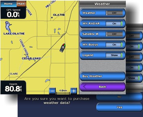
I just added a screen shot to the end of the entry that shows how easy it will be to buy a day of weather data via the GDL 40. It also confirms the fact that the cellular modem can pass data both ways. It may only be able to say “buy weather” at first, but your boat’s electronics network is talking to a server ashore, and that’s what I find intriguing about this product.
Ben,
I do not see the value in Garmin’s solution compared with XM/Sirrus. For a cellular solution, there are more apps for iPads/iPhones/Win7 and Androids – many are free or much lower cost.
I do agree that there is an opportunity for a vendor to come up with a NMEA2000 interface to an alarm solution. Maretron has alerts and email notification but the cost is way too expensive for my needs because it needs the N2KView Premium.
Right now I use remote desktop software to be able to access my boat when I am at work or away from the boat. It is very interesting how far behind the marine industry is behind the consumer and PC industry. PCs with virtualized instances allow many solutions to run on one piece of hardware.
Garmin is not in the habit of developing stuff without a good solid marketing plan. There’s more to come.
I just installed a sample GDL 40 in the lab and was immediately impressed with how fast it loaded in weather data, and how fast it displays it. The XM Satellite Weather I tried on the same 7212 was somewhat poky at both. I believe it’s because the GDL 40 is a two-way device and hence can tell the weather service where you are when you push the button to buy 24 hours of data. Then it delivers a block about 625 miles square, instead of sending you weather for the entire country XM style. I got the 625 figure from Garmin’s new GDL 40 page and can also see it on screen:
https://buy.garmin.com/shop/shop.do?cID=394&pID=62133
Ben,
Depends on when it was approved by ATT. I know that they will now no longer accept/certify any new devices that use only 2G/EDGE modules, so 3G (with 2G fallback) only now. Happily, these modules have fallen into the US$25-30 range now…
This product is now being released, with an interesting pricing model, ie £4.99 per day in the UK and €4.99 in europe, resulting in the UK getting royally ripped off it seems, with the europeans not far behind.
Given that they say roaming charges apply, how will it work in practice in Europe, when near borders cell providers change all the time, how is all this controlled from the chartplotter??.
I think its a product that needs more thinking
Dave
Cant really see what the advantage of this is over Navtex especially in Europe, for the text WX, apart than the usual deal of it being proprietory, and on NMEA 2000.
Navtex has hundreds of miles of range and is free and universal everywhere except the US which is poorly covered and AUS which doesn’t have any.
I’m sure someone will come up with an NMEA 2000 Navtex soon.
Looking at the unit I doubt that the antenna is very efficient anyway, it needs a great deal of effort even with GPRS to make the signal useable at a decent distance offshore, and a unit this size isn’t going to provide that.
Steve
Steve, Does your Navtex have nearly real time NEXRAD precipitation radar and/or lightning strikes that can overlay on the MFD at your helm? Hello! Sorry, but I don’t understand how any text-based weather can be equated with a multi-source graphic system that’s integrated with a marine nav system.
It happens that I personally like viewing NOAA text weather forecasts via satellite or this new cellular system, but please note that I often find this more useful than looking at the exact same forecasts via PC or mobile device. That’s because they’re right at my helm and very easy to call up from the graphic interface (CE also good in this regard).
I’ll typically look at the forecast for my own little region and then the adjoining ones to see the general trends and also the differences of meteorologist opinion. Navtex over here is similar to NOAA text and VHF but less fine grained.
And none of it is comparable to the real time radar and lightning data. One tells me what’s supposed to happen while the other tells me what’s actually taking place. A next step is looking at the big picture model data that the meteorologists base their forecasts on, as discussed in today’s entry: http://goo.gl/hjCp4
Ben, your comments maybe fine for US customers but for Europe most of the systems you mentioned arnt available anyway. Garmin make it as clear as mud what exactly you , as a European customer get. Navtex is as real time as practical here in Europe. And as I said before they don’t indicate how you will handle inter-country roaming.
It’s a bit of a ” product looking for.a Market ” as anything.
Dave
Dave, I have nothing against Navtex at all, but my point was that an integrated graphic weather service is quite different and it’s likely that some boaters will find that it has serious advantages. I don’t know what Garmin will offer for data in Europe, but I’m curious why the product has made you angry. You don’t have to buy it, or even think about it.
Incidentally, I know that in the U.S. a Garmin weather user can specify “no roaming” and I imagine they’ll enable the same option over there. Maybe you don’t have to worry so about people getting ripped off?
Im afraid I have to agree with Dave. There are some technical reasons why this is not really suitable for Europe. Obviously here it will have to use 900/1800 GPRS or EDGE, unfotunately 2G data is now so cluttered with kiddie text, M-M interfaces, cash registers, all sorts of data and control applications, that it will make it difficult to get a connect especially on higher towers which serve coastal regions and are very busy. By and large 3G coastal coverage in the EU is markedly better than the US, because the carriers are regulated nationally and by the EU and required to provide coverage as far as possible up to the territorial limit. So to make any headway in Europe, it will have to use 3G at 2100Mhz and 900 when that rolls out, to get any sort of stable connection. Cell towers allocate a priority to each usage with Voice being top, and also Emergency Services/Govmnt services, and corporate customers being highest. On a 2G system, private data comes way down the list, whereas on 3G it’s priority 2 after voice on most networks, and No1 on some like 3UK.
The other reason is that any vessel really looking at a gadget like this will probably already be internet enabled via 3G and all those services will already be available on the web, for instance worlwide Navtex weather from http://www.gmdss.org, met charts and sat imagery from the UKMO, Meteo France and other Euro weather services, grib files from several free sources including ww3, and nearly every boat in Europe is Navtex enabled, it’s pretty much the second purchase after a VHF. It’s quite difficult for US peeps to imagine just how universal Navtex is outside of the US and Australia, every country, including Russia and even North Korea maintains a viable Navtex service under their GMDSS/SOLAS obligations. Here I can receive about ten Navtex stations which not only disseminate Weather Info, but Navigational Saftey info as well, so it’s a sort of all-in-one marine service. If you want the weather/ RNW forecast in sound you can listen to the CG broadcasts every three hours throughout Europe and the middle east and asia.
Basically this might appeal to US boaters but I’m with Dave that it’s old tech looking for a market, rather than giving us anything new. Cant see it making any inroads at all in the EU. Obviously to a completely Garmin enabled superyacht it’s small change, but as a stand alone I seriously doubt it. BTW Pay per day 500MB PAYG 3G data valid for up to 48 hours costs £2.00 ish. here on most networks, thats a lot less for being able to do 100 times more than the Garmin deal.
Steve
Ben, I’m not angry about it at all, I just don’t understand what garmin are trying to do with the GDL40. I suspect the product is am offshoot of their recent personal tracker product line. I also think that the move is prompted to try and build on-going services revenue rather then relying on one off hardware sales.
a far better product for the Europeans would be a Garmin network navtex. Navtex is always forgotten about by US suppliers and Garmin is unfortunately a very US – centric operation ( I am a supplier to Garmin)
I agree with Steve that is has to be a 3G product to have any hope in Europe. My question about roaming is that it’s not clear how it’s handled. Or can I enable it on the chartplotter or whatever interface is used to control it. Because in Europe i may need to enable and disable this on the fly. ( and pay the horrendous intercountry roaming charges) These types of products have very limited European take-up. The EU Commission is in the process of gradually forcing telecoms companies to adopt EU wide tarriffs and it will come, but we are a while away yet.
Dave
Dave makes a valid comment about the EU. They have already regulated and capped the inter-network charges that networks charge each other for entry into their networks, this has resulted in much lower call charges at national level, but has some way to go to implement a pan-euro customer rate, but I have no doubt that it will happen, although the global giants Like Vodafone which incidentally “owns” Verizon, and Deustche Telekom (T-mob) fight this heavily.
In Europe cell carriers are seen as Public Services, wheras in the US they are pretty much commercial entities allowed to do as they plesae, at least that’s what it appears to an outsider.
Anyway to get back to Garmin, what makes me angry is why they want to charge us in Europe more than the US by about a third, hardly seems fair now does it for a lot less useful data.
Dont get me wrong I like Garmin and always have had one of their products on my boats (currently a 551s) which I have always used as NMEA central.
I noticed something on their corporate site, which now says that they are incorporated in Switzerland, where as before that was Cayman.
I wonder why they have decided to move out of British control and into a neutral country? maybe something to do with the Raymarine Deal?? who knows.
Steve
Surprised and sorry to report that the Garmin GDL 40 weather system was discontinued. Anyone know why?
https://buy.garmin.com/en-US/US/on-the-water/discontinued/gdl-40/prod62133.html