Icom M424G & 324G VHF with GPS, and DSC embarrassment
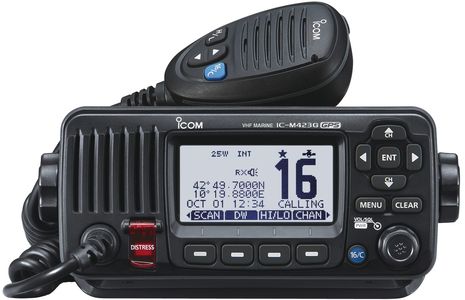 I’m visiting Gizmo in less chilly North Carolina for a week (before TrawlerFest) and was reminded that just before leaving in November, I experienced the first DSC Urgency message I’d ever seen. My reaction was slightly embarassing, but the U.S. Coast Guard response was impressive, as will be detailed below. For now, let’s just say that DSC is a potentially excellent but underused safety tool and thus, it’s good news that Icom has upgraded two of its fixed VHF radio models to include internal GPS sensors, so they will be ready to make DSC distress calls almost the moment power and antenna are attached. At the London Boat Show last week Icom UK introduced the IC-M423G above, which features a “striking new white backlight LCD” as will the M424G U.S. version…
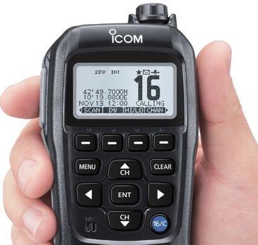
Icom Japan has details of the IC-M424G which will likely soon appear at Icom America. (I think that weather alerts are the only substantial difference between American VHF radios and the ones built for the rest of the world, but maybe a reader can fill us in.) As seen above, there will also be a new M-195G Commandmic IV with a matching white backlit LCD (and either a black or white casing). Given the advent of the premium M506 AIS/VHF, I was hoping to see more NMEA 2000 radios from Icom because they can integrate nicely with multi-function displays and external GPS. But having an internal GPS like Standard Horizon trail blazed is also a good thing. Then you have DSC distress and other features available even if the rest of your nav system and N2K network are shut down. Note that the new Raymarine Ray70 has it all — N2K, AIS, and internal GPS — which is a first, I think, and one I hope to see in action next month at the Miami show.
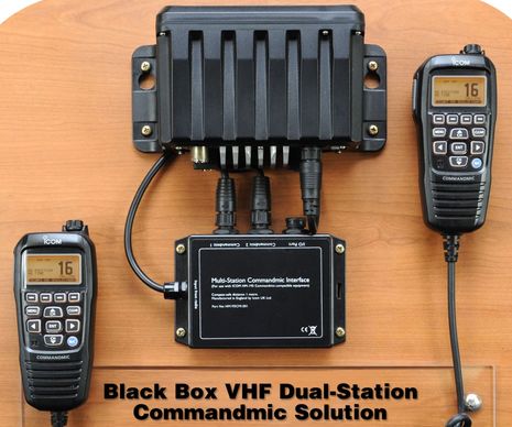
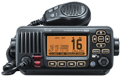
Then again, the new Icom M324G “value” VHF — which looks just like the European M323G above — is apt to go on boats with more modest systems and perhaps no NMEA 2000 at all. So, having the internal GPS saves having to do the NMEA 0183 connection that seems so often undone or failed. I haven’t seen prices for these new Icom models yet, but at least here in the U.S. we’ll probably have to wait for the FCC approval. In the meantime, at Icom UK I noticed the interesting Black Box Dual Commandmic Solution below. It probably works with the M400BB Black Box VHF sold here, but it’s an Icom UK product.
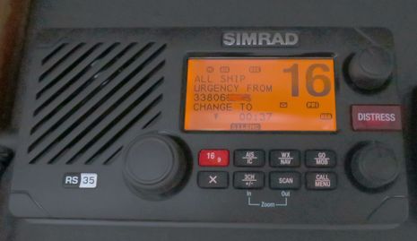
 Now here’s what happened when the Simrad RS35 I’m testing emitted a loud DSC All Ship Urgency alarm one quiet day at the (truly excellent and affordable) Bridgepoint Marina. I switched and listened to Channel 16 as suggested by the radio, and after a period of silence, I even called out on 16 to see if anyone was really in trouble. However, the only response I got was from a somewhat distant Coast Guard station that had heard my call but not the DSC alert. I misinformed them about what I’d seen on my radio (which did not include a GPS position), because it was only when I later looked at the photo below that I realized it was actually an Urgency call and not the higher level Distress call.
So there’s an embarrassing example of how inexperienced most of us are with DSC, I think. But that’s not the end of the story. That evening in the marina laundry room a woman described the strange experience she and her husband had had that day while uninstalling a VHF on their recently purchased boat. The USCG had called to inquire about their safety after tracking the MMSI number I obscured below to the original owner and then through the broker to this couple who didn’t even realize they’d accidentally fired off an alert! So I was embarrassed again and apologetic, but also very impressed that the Coast Guard had gone to such trouble. Image how well they’d respond if you have a DSC VHF with GPS input properly installed and you push the red button under that protective Distress door for a few seconds, especially now that Rescue 21 is fully operational for nearly 42,000 miles of U.S. coastline.






Do any of these built in GPS radios have a connection for an external GPS antenna?
My Raymarine Dragonfly (backup plotter/backup fishfinder) loses GPS signal inside my pilothouse.
Since you’re confessing embarrassment, I’ll confess to limited knowledge, tho’ I’m a huge fan of Panbo.
I wonder if you could clarify something that I think you may be alluding to with the reference to the new Ray70 VHF. With a Raymarine e series system and NMEA 2000, is it possible to see the location of a vessel in distress on an MFD if they’ve activated a DSC alarm? Is that what is meant by “DSC support” on MFDs?
You showed a screen shot last spring of something that seemed to do this (“More Ray LightHouse II goodies” — Mar 15), but said you needed to verify its functionality. When I mentioned this to someone at our yard, they thought it was not yet available.
http://www.icom.co.jp/world/support/download/brochure/pdf/IC-M424G.pdf
This suggests that the Icom M242G does take external GPS data. “The GPS data source is selectable from internal and external GPS.”
While it’s nice to see Icom offer that option, in a way, I sort of hate it when plotters or plotter/finders tout that they’ve got an internal GPS so that you don’t have to hook one up. It’s one thing if you are in a sailboat cockpit with a sunbrella bimini. Another thing if you’re in a steel commercial fishing vessel and often somewhere in between.
Has a tendency to lead to returns or at least cranky phone calls, despite how well you may have tried to explain this before a customer bought it.
I guess I should have been clear… I wantonly like a radio with an internal GPS receiver but has an external GPS antenna. We loose GPS signal inside our aluminum pilothouse.
I would like to remind you all of pioneering project in integration of VHF and GPS, unfortunately dropped off early, most probably because of GPS performance issue at that time:
https://buy.garmin.com/en-US/US/on-the-water/discontinued/gpscom-170/prod31.html
Hi Liz, At minimum a modern MFD should mark a DSC Distress call output on NMEA 2000 (or NMEA 0183) on your electronic chart. In many cases they’ll give you a Go-To choice like in a person overboard situation. Unfortunately it’s a hard function to test!
There are other possibilities for DSC over N2K, like tracking your tender or other boats who are sending L/L positions or are being polled by your radio. Another is to easily set up a direct DSC call to an AIS target, which Garmin made possible with its VHF radios and MFDs years ago.
There’s a screenshot of that somewhere on Panbo and also this polling experience:
https://panbo.com/archives/2009/08/garmin_vhf_200_first_impressions.html
Ben,
you are not the only one to misunderstand DSC and all its capabilities. The lack of education to the end-user is why NMEA and the USCG told us a couple of years ago that nearly 90% of users had not registered for an MMSI number,even though the system has been in place since 1999 and mandated on new VHF radios built since then (I believe you were at that NMEA Conference).
All too often I get the phone call that “my radio keeps beeping at me” and the users response is to turn it off, thinking it is malfunctioning. In reality, it is a DSC call, perhaps an “All Ship”, an “Urgent” or even a “Distress”.
The good news is that VHFs are one of the few products that actually still come with a good old print manual in the box. The bad news is that they are almost as thick as MFD manuals. But that is because of all the amazing features the DSC radio can perform. At a minimum, I encourage people (particularly cruisers) to read the sections on sending and receiving a Distress call with their DSC Radios. It could save a life and that life may be theirs!
And dont forget all the other cool features like position polling and keeping MMSI numbers of your pals like a cell phone.
Kristen and Howard, I’m nearly positive that “The GPS data source is selectable from internal and external GPS” means that you can select an external NMEA 0183 GPS source, NOT an external passive GPS antenna.
I did check out the Standard Horizon GX2200 manual and while they reference an optional External GPS Antenna, what they mean is an entire GPS sensor built into an antenna mushroom and connected to the VHF via 0183. There is no physical port for a GPS antenna on the back.
So, yes, this is confusing! Modern GPS sensors with built in antennas can often work fine in places they didn’t use to, like my lower helm, but metal decks and pilot houses are a problem. Maybe readers can help by investigating VHF/GPS radios looking for support of a port for a simple external GPS antenna. I could make a table, though right now I don’t think there’s any.
The same is true for MFDs with internal GPS, as Howard is experiencing. I think that provision for simple external GPS antennas is rare. I do know that the Garmin 741xs I’m testing has one, but then again it will not accept GPS input over NMEA 2000, which is weird.
Well said, Captain Bill, though the authorities deserve some responsibility for making DSC too complex. But then again the primary Distress Alert is fairly easy to use or respond to, and IT REALLY WORKS!
A couple of years ago I toured the Miami Rescue Coordination Center, busiest in the USA, and the outstanding staff there could not have been clearer about the benefits of a DSC Distress Call with proper GPS location. Thanks to Rescue 21 they can triangulate VHF calls using radio direction finding, but it’s so crude compared to DSC GPS. They showed us how quickly the search patterns have to expand over time to allow for the Gulf Stream current and it’s scary. DSC VHF can enable a fast rescue.
Hi Ben, you probably need to set the preferred source in the N2K menu of your 741xs to the sensor you want to use. My wish would be the external analog antenna input and maybe the possibility of using a combo vhf/gps ant.
Thanks, Marko. I don’t want to hijack this thread but I’ll be damned…N2K GPS sources are available on the Garmin 741 now. I know for fairly sure that they used to be blocked, I discussed it with Garmin and wrote about it. But they changed their minds at least by software version 3.80. I just tried it and can choose between built-in, Vesper XB8000, Maretron GPS200, or Raymarine e7. All show satellite status and if Differential is active, but only the built-in shows estimated accuracy.
As for what “DSC support” on a multi-function display might mean, I looked at the response of one popular chart plotter, the Lowrance HDS, to data it received from a connected DSC radio. The results were rather strange. I describe them in
http://continuouswave.com/whaler/reference/DSC_ChartPlotter.html
While the behavior of a DSC radio is quite well described in the ITU-Rec. M.493-13 literature, and most DSC radios tend to conform very closely to the requirements, exactly what your recreational chart plotter will do with data sent to it from the radio seems to be up to the particular manufacturer, their software engineers, and their computer graphics people.
That’s impressive work, Jim, thanks for sharing. I tend to take the glass-half-full view and thus am glad to see that Lowrance MFDs are at least doing something with DSC non distress calls. But I too have seen the mysterious “Grounding Buddy” verbiage and I hope Lowrance fixes it.
I’m not recommending that you do this, but I have tested actual DSC Distress calls by putting all the gear in the basement, using bad antennas, and standing by 16 after the test in case anyone else gets it.
If anyone wants to test DSC or similar equipment and is in the Seattle area, I have the facilities. I have a RF proof room (no radio waves in or out)
Hi Ben–
Many thanks for making this clear. Your reply also makes me realize that I misremembered the conversation at our yard. We were discussing whether you could directly call an AIS target through DSC on a Ray system — and that was what they thought was not yet possible. Do you know if that will be a feature of the new Ray70?
I have made tests of DSC distress messages by using 50-Ohm dummy loads for the transmitting radio. There is enough signal leakage from the dummy load that a receiver with an antenna near the dummy load will be able to receive the transmissions. I am also about 20-miles from the nearest Coast Guard radio tower, I use double-shield coaxial transmission line, and I put the dummy load inside a metal enclosure. I am reasonably sure my test distress transmissions were not received by any boaters or the Coast Guard. It trying this sort of testing, you need to take precautions you are not really emitting any signal on the air.
I have links to those tests in the article I mentioned earlier.
Re having a radio automatically set up a DSC call to a vessel that it knows about because it received an AIS transmission from it, I believe that most radios that can do that are using a proprietary method, and the method is just based on parsing the AIS data. At least that is the impression I got from talking to one radio manufacturer whose radio can do that.
No sure I read the thread correctly, but thought I would add my 2-cents.
There is a DSC test function on almost all DSC radios that calls the USCG in the US. The USCG sends back an acknowledgement.
Cheers
Don
That’s true, Don, but I believe that the test is an individual DSC call, not the All Ships Distress call that should show up on networked MFDs. Here’s more info on how to test DSC with Rescue 21:
https://panbo.com/archives/2011/08/automated_vhf_radio_checks_sea_tow_uscg.html
I just tried it here in New Bern, NC, with Simrad RS35. I got no response but I did damage my VHF antenna on an over hanging tree in the Great Dismal Swamp.
Ben,
Captain Bill makes mention of the biggest problem today-
“The bad news is that they are almost as thick as MFD manuals”
referring to above article.
May I suggest to manufactures to take a page from Apple and simplify the instructions- because with your experience this happens, think of the majority of recreational users who are not comfortable and therefore either taboo the capability or over-rely on the capability.
I have the Standard Horizon GX1700, which is the one with GPS, but NOT AIS and there is a menu option for using the internal GPS or NMEA 1083 GPS. I have tried it both ways and it works fine. It also outputs the GPS and DSC info the same way.
I plan to get the Vespar XB8000 for AIS. I had the 2150 VHF/AIS on my last boat and it was great, but I really wish there would have been a way to disable the AIS part of the radio as the current draw of that radio is much higher than a regular VHF.
Jim writes “exactly what your recreational chart plotter will do with data sent to it from the radio seems to be up to the particular manufacturer”.
So far as I can see, most plotters create a waypoint at that location. I even came across a function in the Brookhouse NMEA0183 multiplexer to convert the DSC+DSE pair of sentences into a waypoint (WPT) sentence as this is better understood by plotters.
This may be a good idea insofar as you may want to navigate to it but it won’t stand out well among other icons overlaid on the chart, primarily AIS targets.
In my opinion, a DSC caller deserves its own data type simply because it’s not a waypoint and also not an AIS target (though I concede it’s be closer to an AIS target).
Coastal Explorer uses a simple red dot with the MMSI number next to it. I kind of like this approach as it normally stands out well. More information could be presented via that icon, most importantly nature of call (distress, urgency, routine) and time of call (also possibly distance and bearing) but the current status satisfies my basic need good enough.
However, there is the question of layering. CE and also Open CPN put AIS targets on top of everything else. Even radar in the case of Open CPN, which I think is bad as it keeps you from verifying if an AIS target is also a radar target – particularly interesting for virtual AtoNs but also in many other cases (though Open CPN has be big button to turn on+off all AIS display – CE has this only hidden in deep in the menu).
Waypoints are at the lowest level with most devices (I believe), which is mainly why using this for a DSC caller is bad. If the DSC caller is also an AIS target, you will never see it until the AIS target has moved away from it’s original location!
I don’t feel the need for an alerting message on the screen as I already have to acknowledge the DSC alarm on the radio. An old Simrad CP31 had just the message covering the entire screen and no position indication at all – the opposite of what I want. I generally don’t like anything that can cover up the chart at any time without my control. You may not have a hand free to remove the message and you way really need to see that chart right now.
My personal opinion on layering is:
Safety/emergency objects go on top (AIS SARTs and MOBs and DSC callers, irrespective of call nature).
Next comes radar which should have a settable level of transparency.
Then AIS targets which ideally should be semi-transparent or, as defined by the AIS standard, be hollow triangles (just an outline and transparent inside). If they are hollow, then, alternatively, they may go above the radar but I still prefer underneath.
Waypoints, routes and other marks are on the lowest layer over the base chart with its navaids, tidal stations and and all else.
Close to Dover, UK, I received a DSC distress call and wasn’t immediately able to find the red dot. On zooming out, I saw a huge clutter of AIS targets and still no dot. Finally I found part of it peeking from under AIS targets a distance away on the French coast
After receiving the call I zoomed out some – not dot to be seen:
https://www.wuala.com/Henning_Duerr/Photos/Panbo/20140731_4.jpg/?key=jpfZjtFgeZBX
Zooming way out and finding a trace of the red dot:
https://www.wuala.com/Henning_Duerr/Photos/Panbo/20140731_3.jpg/?key=jpfZjtFgeZBX
Zooming in on the red dot and finding it’s on dry land – so no emergency, at least not “maritime”. There also seem to be two reports with different MMSIs from the same position. Apparently some “test” like what is discussed above 🙁
https://www.wuala.com/Henning_Duerr/Photos/Panbo/20140731_2.jpg/?key=jpfZjtFgeZBX
And finally, a little unrelated, here is a screen showing the dot from polling my SH HX851 DSC handheld for its position from the boat’s SH GX2000 (I placed the handheld on the dock nearby). This is what I have for a MOB alerting and locating solution.
https://www.wuala.com/Henning_Duerr/Photos/Panbo/20140502_DSC_DSE.jpg/?key=jpfZjtFgeZBX
Henning—your comments are very cogent and informed. It is comforting to know that there is at least one other person interested in how recreational grade chart plotters will display vessel targets from DSC non-distress-alert messages.
I don’t see any sort of agreed-upon standard for presentation of this data on a recreational grade chart plotter. Your ideas are certainly interesting.
Ben,
Just saw this recent article of yours on DSC, and thought I might pass on some info that some might find helpful.
I recently uploaded some new videos, specifically dealing with DSC.
Although, I mostly concentrate on HF-DSC, there is a good generic description of DSC and procedures. And, I included a few other videos dealing with VHF-DSC in the Youtube playlist as well.
So, if you or others have an interest in DSC explanations / training, etc. please have a look at these videos…..provided for free to all, as a helping hand from one sailor (w/ > 40 years experience in offshore sailing and radio comms) to all my fellow sailors.
Have a look at these Youtube Playlists:
HF-DSC Communications
https://www.youtube.com/watch?v=D4PO3S6AELQ&list=PLnN6ygtZ3h2n3z5nlv-ga2zYuPozhUXZX&index=1
(which currently consists of 15 videos showing/demonstrating the features and capabilities of HF-DSC signaling, as well as detailed explanation of what DSC is, how it works, and why/how you should use it…the last 3 videos deal with VHF-DSC)
I have also uploaded other sailing, radio communications, and weather videos, and have them loaded into playlists as well…if anyone has interest in these topics, please have a look.
Maritime HF Communications (“HF-SSB”)
https://www.youtube.com/playlist?list=PLnN6ygtZ3h2nPNdApNsZDo_Jk3NB_Bt1y
(which currently consists of 16 videos, showing/discussing: radiowave propagation and channel/freq choice; atmospheric and man-made noises; radio-telephone calls; Distress Signaling; explanations/demonstrations of HF-DSC calling; etc. etc.)
HF-DSC Communications
https://www.youtube.com/playlist?list=PLnN6ygtZ3h2n3z5nlv-ga2zYuPozhUXZX
(which currently consists of 15 videos showing/demonstrating the features and capabilities of HF-DSC signaling, as well as detailed explanation of what DSC is, how it works, and why/how you should use it…)
Icom M-802 Instruction Videos
https://www.youtube.com/playlist?list=PLnN6ygtZ3h2npivDjoFrC-8QKVyMb4tVr
(which currently consists of 18 videos, showing/discussing: basic and advanced Icom M-802 instructions, use, and programming;……along with radiowave propagation and channel/freq choice; atmospheric and man-made noises; radio-telephone calls; Distress Signaling; explanations/demonstrations of HF-DSC calling; etc. etc.)
Offshore Weather….procedures, sources and applications
https://www.youtube.com/playlist?list=PLnN6ygtZ3h2mPZAx2vWzdjTJjHlChruyY
(which currently consists of 7 videos explaining and showing/demonstrating, exactly what weather sources are easily available to sailors/cruisers when at sea or in remote locales, showing/demonstrating both SSB Voice Weather Forecasts and WeFax Charts, worldwide….)
Offshore Sailing (across the Atlantic)
https://www.youtube.com/playlist?list=PLnN6ygtZ3h2nbwAGh5DKgTCj15iyl6qoY
(currently has 2 long videos, of my more recent Atlantic crossings)
Fair winds.
John, KA4WJA
s/v Annie Laurie, WDB6927
MMSI# 366933110
Dear Sir,
I have dsc vhf icom ic- m242g, I did loop test vhf showing OK, communication receiving/transmitting ok but while routine test doing trans-receiver getting off.
Thanks & best regard
Akshaya