Whale Alert, an app with a mission
It’s an unusual app that gets a press conference and main stream media attention, and Whale Alert certainly deserves it. It’s not just that this app might actually save the lives of some rare right whales — which would be wonderful — but it also demonstrates how mobile devices can be a critical integration tool between mariners and various governmental and nonprofit agencies, and between even a big ship’s conservative electronics and the dynamic world of app development…
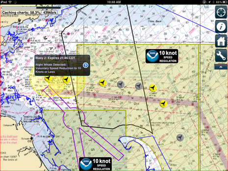
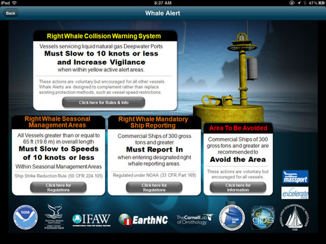
I’m in New Orleans now — hence the CDT time stamp on the screen above — and so I don’t need to know that right whales have been detected within five miles of several Boston shipping channel acoustic buoys today, but I like knowing it. And I especially like knowing that ships and boats in that area now have a screen that can alert them to be especially careful about following the mandatory and voluntary speed restrictions, because these mighty mammals — hopefully accompanied by nursing calfs — apparently don’t always know to get out of the way of a fast moving hull. And note that the seasonal danger areas extend all the way to Florida, and you can learn all about them from this app…
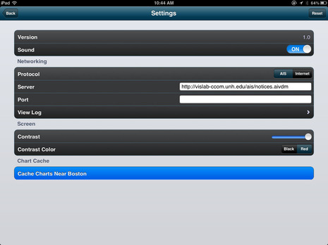
Whale Alert is available free for iPhones and iPads now, and I suspect an Android version will be along soon. That’s because the app was created by EarthNC, which already supports both platforms with its charting apps. EarthNC is a good place to learn more about how Whale Alert came to be and how it works, but don’t miss the NOAA Whale Alert site for more, including the manual which explains how it can connect to a ship’s AIS. Yes, a special AIS message is being used to get the warning info direct to vessels and also to the Internet (via cellular perhaps?).
Do you suppose the whales are concerned about their privacy? I joke but isn’t it interesting to imagine other ways important information can be distributed to boaters like this?


Note that Whale Alert can work with iThing GPS to notify you when your boat enters a right whale management zone.
Our experience with this offshore area is anything with “i” in front of it is generally useless before you get to the inner boundary of the whale zone, much less in the zone.
I suppose the folks who can afford the giant white gumdrops will benefit, but I can’t see this being a lot of help to the coastal cruiser with modest electronic resources. By the time we get to the area of interest the whale’s positions have returned to random (perhaps not to the whales).
From an ecological perspective, good on ’em!
Christopher, I think Whale Alert will let you know if you’re entering a whale management zone without a cellular connection. It just needs GPS. Only one portion of one zone has real time acoustic whale monitoring and that can be received directly over AIS, also without a cell connection. However the only NMEA 0183 to WiFi adapter mentioned in the manual is the Digi Pilot Plug:
http://www.pilotplug.com/aistowifiiphoneipad.html
In other words, the real time direct-from-AIS monitoring is designed for ships, but then again yachts are just getting into the world of NMEA data over WiFi and it will include N2K and encapsulation standards eventually. Also short burst sat data devices like the DeLorme inReach could handle this whale data.
I have a feeling the commercial tuna guys are going to love this app.
The whales will be on the bait, and so will the bft. Find whales, and tuna will be in the neighborhood.
So in the perverse world of unintended consequences, this may actually cause more harm than good in some ways.
The whale watching boats will just love this app as they bring boat loads of city folk out to gawk at and harass the poor whales. Their businesses are very competitive and they are so obligated to provide whales for their customers that it is almost dangerous to be anywhere near whales for fear of being run down. I say this from personal experience aboard a sailboat transiting from Cape Cod Canal to Portland.
Ben, good info. Actually, an unintended consequence of this dialog is you may have pointed me to the solution to my VesperMarine mounted in the Nav Station information needed in the cockpit problem.
Thanks, Chris
I’m skeptical of the skepticism. There’s a tremendous amount of brain power and on-the-water research experience behind this app. I’m sure that the scientists are quite aware of the sport fishing, commercial fishing, and whale watching situations, and wouldn’t have made this app and the real time data so easily available if they didn’t think it would result in a net gain for the whales.
Check the credits:
“Whale Alert has been developed by a collaboration of government agencies, academic institutions, non-profit conservation groups and private sector industries, led by scientists at NOAA’s Stellwagen Bank National Marine Sanctuary. Collaborating organizations include the sanctuary, Bioacoustics Research Program at Cornell University, Center for Coastal and Ocean Mapping at the University of New Hampshire, EarthNC, Excelerate Energy, EOM Offshore, Gaia GPS, International Fund for Animal Welfare, Massachusetts Port Authority, NOAA Fisheries
Service, National Park Service, Cape Cod National Seashore, NYK Lines (North America), United States Coast Guard and the Woods Hole Oceanographic Institution.”
To chime in on some of the comments –
– The acoustic buoy array simply detects whale calls within ~5nm. If a call is confirmed, the area goes ‘active’ for 24 hours. Even assuming a boat is in the local area at the time of an alarm, a 10nm diameter circle of ocean is a large patch within which to try and find any individual animals. No range or bearing information is provided in the app.
– The buoys are along the centerline of the Boston TSS (main shipping channel), which was positioned to align with the area of least seasonal whale traffic – so the channel is a poor place for whale watching in general
– While we’ve tested primarily with the Pilot Plug, our AIS option should work with any serial AIS-over-WIFI solution. The IP and port is configurable in the app settings. Right now, the App only listens for Whale and DMA messages, not general ship traffic. AIS coverage for the whale messages is limited to the Cape Cod area, but there is work under way to expand coverage via additional shore based transmitters
– The app receives data in a number of ways, all with a view of maximizing usefulness both ‘connected’ and ‘unconnected’
Cached Via Internet (when connection is lost, these will continue to be shown unless they expire, layers will update automatically with a new connection):
— Seasonal Management Areas (SMAs)
— Dynamic Management Areas (DMAs)
— Mandatory Ship Reporting Area
— Recommended Routes
— Areas to Be Avoided
— Acoustic Buoys
Cached Via AIS (when connection is lost, these will continue to be shown unless they expire, layers will update automatically with a new connection):
— DMAs
— Acoustic Buoys
As Ben suggests, we had a number of detailed discussions with the various partners on what data to include in the app to maximize usefulness to operational traffic while minimizing any negative risks.
– Virgil
EarthNC
Ben et al,
Thanks for the great write-up on the app and your clarifications, some of which are worth repeating:
1) The seasonal management areas “geo-fences” do not rely on AIS. They are native to the app and will be triggered by your in-device GPS – so off-shore support is there.
2) We (and the agencies you list below) deliberated at length about the mis-use of apps like this and decided the merits (awareness, in-app live guidance et al) far outweighed the aforementioned risks. Included in this discussion was the reminder that most commercial interests (including whale tour operators) are good actors and that the penalties for violating observational boundaries et al have not changed. Its finally worth noting that law enforcement has an equally good tool (now) in finding the bad guys (where else would you go to find them?). I sent this link to a couple of NOAA / Coast Guard folks so hopefully they’ll have the time to weigh in here.
3) We’ll be working with the agencies on monitoring how the app is being used, how it can be improved etc. So, in addition to making sure we’re not unwittingly exacerbating the plight of right whales, we hope to learn how the app itself, and some of the underlying technical innovations can be better used by the general boating community (we have, for example, included the SMA layer in our Marine Charts app).
Hope this helps. Thanks again for the great coverage and we look forward to the continued feedback from your readers.
Brad Winney
Co-Founder, EarthNC, Inc.
Actually, Whale Alert will be of no benefit to the commercial tuna fleet. Right whales feed on copepods, a small marine invertebrate about the size of the period at the end of a sentence. Tuna feed on sand lance fish, so right whales and tuna do not tend to co-occur. Humpback whales feed on sand lance fish which are also fed upon by tuna, and it is humpback whales that the tuna fleet tends to target. While I agree that we need to be aware of unintended consequences, a great deal of “systems thinking” has gone into the creation of Whale Alert. For example, we also considered the possibility that recreational and commercial whale watching boats could use Whale Alert to find right whales and increase risk of a vessel striking a whale by increasing the number of boats around them. This is an unlikely byproduct of Whale Alert since most of the app shows areas of historic right whale occurrence, not a point of sighting. These areas have been designated as Seasonal Management Areas (SMA) in which ships must slow down to 10 knots or less. They cover hundreds of square miles and are active for several months. Thus, they are not particularly helpful to someone wanting to go out and see a whale today. The acoustic buoys provide a closer to real time detection mechanism. However, the acoustic buoys are located through the shipping lanes and, in 2007 the Stellwagen Bank National Marine Sanctuary and other parts of NOAA moved the shipping lanes into the areas least used by whales. Therefore, if you wanted to see a whale they would be the area least likely to have one.
The industry’s Chamber of Shipping of America would disagree:
“Kathy Metcalf of the Chamber of Shipping of America, a shipping industry group that wasn’t involved in the project, called the app fantastic, and said she “can’t imagine a reason” why any mariner or boat owner wouldn’t want it.
The cost is “beans,” Metcalf said, and the benefits are substantial. By locating where whales are, and detailing any restrictions in effect to protect the animals, the app enhances a mariner’s general awareness of the situation at sea, she said.
“If you don’t want that, you’ve got problems,” Metcalf said. “No one on a ship wants to hit anything in the water, whale or otherwise.””
Copyright 2012 The Associated Press. All rights reserved. This material may not be published, broadcast, rewritten or redistributed.
As the lead designer of the notification system that feeds data from Cornell to the EarthNC Whale Alert app, I have to say ditto to what Virgil and Brad said. I have spent huge huge amounts of time since 2006 working on the issues described above with many USCG and NOAA staff.
Key thing to remember: Do NOT approach a right whale. You will get yourself into lot of legal trouble. Plus, you are not going to want to hang out in the TSS!
Please do give the team feedback about what works or doesn’t work for yourself. If you have a question about how the rules apply to your boating, please ask for a clarification. If you don’t know the rules about marine mammals, please contact the USCG who will give you the skinny about how to boat safely in areas with whales.
BTW, integration with onboard AIS should be a ton easier for small boaters with Class B AIS systems compared to the complexity of class A AIS (not so much fun from my experiences). I so wish that the AIS ITU 1371 folks had mandated a 2nd RS232 DB9 serial port next to the pilot plug. They are considering a 2nd pilot plug, but why not make life a lot cheaper by saying either RS232 or Wifi as the requirement?