
Google Sat Images, Katrina before ‘n after

I was a bit taken aback when the wonderful Keyhole was rebranded as Google Earth; it sounds so pretentious. But, geez, it just keeps getting better. Now there’s a free version of G.E., plus they’ve just posted hi res sat photos of New Orleans after Katrina and made it easy to compare them with “before”. These particular images actually came from Google Maps, which is easy to access with a Web browser, but they are also available in G.E., along with super high res daily overlays from NOAA (though I haven’t been able to make the link work yet).
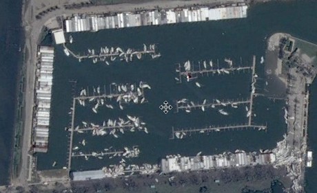
This a marina on Lake Pontchartrain that obviously got walloped by Katrina, despite pretty good protection. That’s a big pile of boats lower right, quite visible zoomed in (I’m hoping no one was there trying to save their ship). I think this marina is where I once began a wild ride on a power yacht aptly named “Bontemps Roulez”. That was way back in 1972, while spending a winter in N.O. working on oil field boats and falling in love with the Music City. Unfortunately I’ve never been back, and now the good times have clearly stopped rolling, at least for a while.


Recent Panbo Comments