
POIs, what do you think?
I’m working on a column about the “Points of Interest” we get on electronic charts these days. I think they have wonderful potential, but these days are often inaccurate, plus hard to use. Above, and full screen here
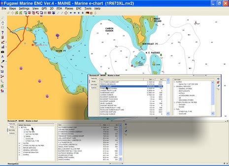
, is an example of an interface that seems to work pretty well, Fugawi ENC’s new ability to work with Navionics Gold+ (Platinum too, but many features aren’t supported yet). Note on the inset how you can easily search for harbors and marinas by distance from your present position, or (inset) narrow your search by multiple service criteria. Some other charting programs, and particularly plotters, are clumsy to search, lead you to empty data screens, etc. Plus, like every other electronic chart I’ve seen (all available, I believe), there are numerous errors/ommisions in the POI location and details presented here. Where, for instance, is info on the Camden Public Landing, possibly the POI of highest interest to visiting boats? So I have some questions for you all:
* Do you use electronic POIs when boating, or do you prefer printed guides, or both, or do you just ask around?
* Which electronic charts have you tried and what’s good or bad about each’s POI data and the particular interface used?
* What’s the future of POIs. I see a lot happening on land—like automated (Bluetooth) POI calling, user generated POIs and georeference photos, sites dedicated to sharing such info, etc. Not to mention Google Earth, Microsoft Live Local, etc. How and when will these advancements come to boating?
")


I believe for coastal crusing the internet needs to be the way to go. When it first got going as a public resource, I envisioned a series of sailing/cursing home pages which yachtsmen could access with a PC on board, at Net Cafes or any of the numerous WiFIU hot spots etc.
What I envision then (and still do) is for example the Long Island Sound Page. The site would offer real time current data about the region, weather and tide infor (just click on a location on the map and get the data… or marine services… restaurants, historic information, races and recreational amenities (bowling whatever) shops and ground transportation information… you name it. Why use the same out of date concept of a crusing guide… good as they are when the data can be more robust, and constant current! It’s the wave of the future.
I say keep the paper charts and use the most advanced web based data resources. All the stuff in between, like plotters etc are fun but their charts too are needing to be updated. I like the idea of real current real time data bases possible with the internet.
No?
I do use C map Max chart’s POI–but find even the latest chips on the Gulf coast to not be entirely accurate or up to date. Mostly I go with Southern Waterway Guide, as well as Claiborne Young’s books (for example Cruising the Gulf Coast). Other guide books for the Bahamas. I also get a fair amount of my information on the Internet–Claiborne Young’s Salty SouthEast, and Skipper Bob’s sites.
I also put the Garmin 330 on the boat–and use the POI on the street level charts.
I don’t remember if I followed up with the noise interference on the Lowrance and VHF, which I had discussed with you. Ferrite beads resloved the issues. I also tried using a second NMEA 2000 GPS antenna, and positioning it some distance away–and it made no diffrence.
Best regards,
Bob Austin
I have found the POI from all the sources that I use (Garmin, Passport charts, Delorme Street Pilot, Mercedes) to be fairly unreliable and/or difficult to use. They occassionally deliver something useful, but I don’t rely on them by any means. I think the update cycles are too long and their sources too spotty.
I agree with DefJef that the web is much more current and massively more comprehensive. Probably more significantly, which is likely to progress faster: better mobile internet access, or better chart POI data? I think the economic forces are behind better mobile internet access.
To answer your question directly:
1) I don’t use them while boating (Nobeltec / Passport and Furuno / C-Map).
2) The future is the web. How can a chart POI that I update at best once a year, be as current as the web?
Chart manufacturer’s should focus on their primary mission: presenting navigation data as accurately, comprehensively and effectively as possible.