Memory-Map, new tricks and free starter edition

It’s wicked hot and sticky here, especially at this big computer, so what a fine time to receive a Panbot e-mail suitable as a guest entry! Richard Stephens—developer behind, and sometimes soggy user of, Memory-Map charting software—recently sailed aboard the Tripp 33 TRPXPRS in the Bermuda Ocean Race and reports:
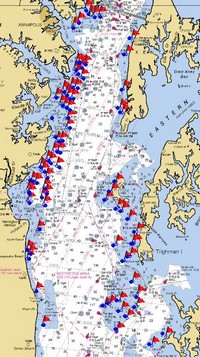
* I’ve never sailed in the Chesapeake before (which is a major part of this race), and  one of our competitors warned me about the Maryland pound nets. If you sail into one of these moored fishing nets at night, your race is over – it can take hours to get out! Fortunately, the Maryland DNR, which issues licenses to place the nets, publishes their authorized coordinates. There are about 700 of them, all over the shallow areas of the bay. I was able to download these as a CSV file and import them into Memory-Map as an overlay. With this information, we were able to keep clear of the areas containing nets. (GPX file of this data downloadable here}
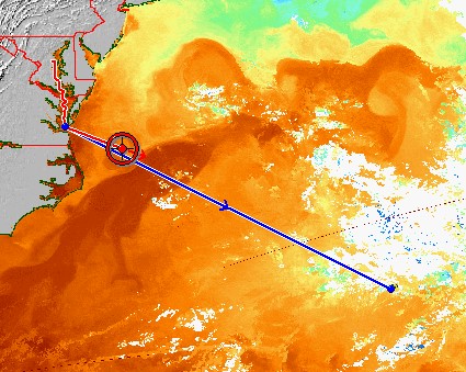
* Next was the Gulf Stream part of the race. Using our map calibration feature, I was able to import our downloaded gulf stream images, and use them as charts in the nav software, with the rhumb line, GPS location and other overlays automatically plotted {see above}. This saved us a lot of manual plotting! It turned out, with the wind we had, we just sailed the rhumb line, and concentrated on keeping the boat moving at top speed. With just four of us on board, there was not a lot of time for strategizing.
On the software development front, there are a few things you might be interested in:
* First, we have implemented a new license management system, which controls the user’s access to our maps. While this is a mixed blessing for many, the map publishing industry really likes it. We have been able to source some interesting additional cartography. For example, the Australian marine charts, which were previously only available as ARCS, are now available in inexpensive Memory-Map packages with bundled nav software.
* Moving in the opposite direction, we decided to remove all license management from the core features of Memory-Map {nice!}. People can now use our free viewer to import the NOAA BSB charts and plot a GPS position. There are, of course, other free nav software packages out there, so we decided to extend our own free viewer to make something truly useful.
* I have added some useful new features to our AIS add-on for Memory-Map Professional: It will now take NMEA 0183 input from a DSC radio, plotting position reports and distress positions. My eldest son is now learning to sail, so I’ve got him a HX850S and I can now ping him to see where he has got to!
* The AIS add-on now outputs the NMEA 0183 autopilot data. We’ve been asked for years for an autopilot output feature, but I’ve always resisted it, as I feel it is one of those things people want on their check list, but very few actually use. Well I’ve finally found a good use for it: the output is fed into my Tacktick Micronet instruments which now display course and bearing to the mark, cross-track, etc. It is great to have this data on the cockpit displays and not just on the GPS.
***************************************
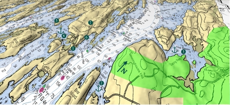
Let me add that I often use the PC module of Memory-Map Navigator for checking out raster charts and topo maps—it’s fast and handsome—and am delighted that anyone else can use it that way for free. I’ve also enjoyed navigating with it on a PDA, and was impressed when I tried Richard’s Weather Radar application for smart phones. Finally, Memory-Map also does pretty good 3D, sort of like you-know-what, a feature I often use to make gunk-holing chartlets like this:


Can we find out if they are working on an iPhone version?
We have an iPhone marine navigation app ready for iPhone. It’s exact availability is dependent on Apple putting it on the new iPhone app store.
The application uses the free NOAA RNCs and uses either the built in iPhone locating hardware or it can receive NMEA over IP from apps like MacENC or Coastal Explorer. There is also tides support.
Pricing will be consistent with other iPhone apps (i.e. low).
Post here in comments or get Ben to cover it once Apple launches it and you will have your first customer.