Amerigo mobile nav, open source

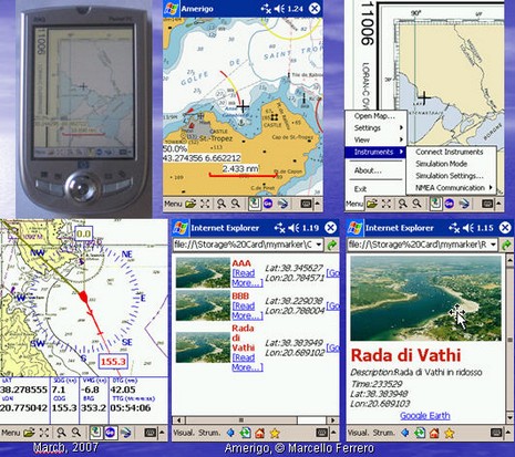
Head’s up, open source programmers. Marcello Ferrero has begun the Amerigo project, navigation freeware meant for PC, PocketPC and WinMobile phones and PDAs. A “PreAlpha” release is out, and Ferrero is hoping some nautical code jockies will join him. One feature that he thinks unique will be the ability to use a Smart Phone with camera to create a photo POI in one click, adding categories and text as desired. But I wouldn’t be surprised to see this sort of feature arrive first from ActiveCaptain’s mobile project, still “under construction”, or maybe EarthNC, or who knows where. Does anyone doubt that Web 2.0 will mash up tight with marine navigation eventually?


Here is something high on my wishlist for the project: https://panbo.com/archives/2005/07/safe_pass_plotting_why_not.html
Agreed! !!
..shame it doesn’t work on WinCE 2002…
I tried the Amerigo program and found that it lacks the power to load large charts at a reasonable speed. It is so slow that i would call it useless. I’ve noticed that is what seperates the freeware\shareware programs from the ones that cost money.
Jenia
Jenia writes “Ive noticed that is what seperates the freeware\shareware programs from the ones that cost money”.
Ouch !! … this is “alpha” software. The project has only started Jenia. The benefits of open source software don’t kick in until their is a community of contributors to augment the original seed work.
Hi all,
good to see there has been such a reaction to this new open source project.
This is a PreAlpha version mainly intended to grow the interest in the development community where I believe there are many sailors that could join the project.
As a PreAlpha version, there are of course bugs and spaces for optimization.
I really invite you to post your feedback to the amerigo forum at sourceforge.org/projects/amerigo.
Your feedback and contribution will help improving the quality of the software and is an unvaluable source of requirements for the new releases.
Amerigo aims to grow in two directions: 1) to a full tactical and navigation software and 2) to a new WEB 2.0 (better to say WHERE 2.0) type of navigation software providing a new approach to the way people gets informed while sailing. My goal in fact is to provide also a web site, the server side of Amerigo.
With this server-side component, users will be able to send POIs with text and pictures from a Smartphone, as well as searching the POIs posted by others in the area you want to explore. Additionally I also plan to add the latest web 2.0 functions such as GeoBlogs, GeoWiki, GeoMessaging and many others.
JOIN the project and help me improving the software both as a user and a developer.
AMERIGO IS AND WILL BE FREEWARE!
Marcello Ferrero
I’m excited to see all the new devices with built in GPS. So when I just tried to link to this project and received an “invalid Project” error…I was bummed. Is this cancelled?
So what happened to this project? It looked interesting, and I’d like to contribute, but the project seems to be offline.
Likewise, I’m curious too, especially having just upgraded my PDA to CE2003 so it can run it!