
Maptech International Charts, prices slashed
One of my happiest discoveries at MIBS was not a new product or feature, but simply a matter of pricing and packaging. Maptech has radically reduced the hassle and cost of owning its international raster charts, really big time.
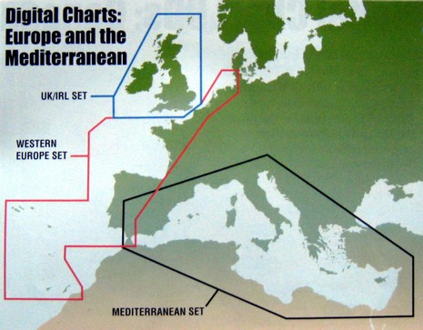
Check out that British Isles region, for instance. If you look at some dealer site, like Landfall Navigation, right now (I’m sure it will change soon), you’ll find that getting all those charts entails buying and installing over 10 CDs at a cost over $1,500 (over 10 encryption keys, too, because licensed charts have to be sold that way). Now go to Maptech’s UK/IRL page, brand new today (I think), and rejoice in the knowledge that you can have all those charts for $150 and one install, with a copy of Offshore Navigator Lite thrown in. $300 will get you the charts and Chart Navigator (ex Offshore Navigator Pro), and the $600 bundle includes CNP (i.e. Coastal Explorer, which is soon to go 2.0, free update for current owners, and looking good in Beta), plus 15 meter NavPhotos and 3–D contour data. Maptech’s chart pages are literally being updated as I blog, but I have the 2008 catalog and can tell you that this same price slashing with large regions available in three alternate bundles is going to apply everywhere Maptech has international rasters (with the unfortunate exception of Canada). I’d guess the latter is because the Canadian HO didn’t cooperate the way others did. I’m sure the skeptics will say that Maptech is just catching up with falling vector chart prices, but I think this move establishes wonderful new price points and is a major shot in the arm for computer charting, not to mention all the navigators like me who like to have multiple chart types on board. Good on ya, Maptech!
PS Pleased to see my prize winning NMEA 2000 article go up at Sail. It’s a year old, but there’s still a lot of truth to it, plus what I was hoping for is really happening now. More on that next week.


Ben,
I too am rejoicing at electronic charts becoming affordable. Kudos to NOAA for making their inventory free.
I have seen no statistics to support my observation, but the number of boats in my local boatyard needing repairs is dramatically down since moving map display GPS’s are now very common. Fuel prices have both slowed down the traffic and reduced the number of boats on the water. This is probably part the reduction in the number go major groundings in the Pacific Northwest.
I do believe that better navigation tools are the real factor in my observation. I wonder if the insurance companies have observed this also. Be nice to get reduced premiums.
Pat Hatman
This is great for the UK. However, they have not changed their pricing for the eastern Med, which would be $750 (5 cds) for the region I cruise in. Hopefully, they will extend their groupings to include additional areas as well. Thank you for the heads up, though. We can keep a lookout.
Gary, I think you’re being confused by Maptech’s Web site, which is only partially updated. I have the new catalog here and that entire area marked “Meditterranean Set” is now $150 for the base (Offshore Nav Lite) edition (all charts, eastern & western Med).
Same price for the “Western European Set” and also complete “Mexico & Central America”. The “Bahamas”, “Puerto Rico”, and the “Carribbean” are now each $80, or $200 for all on DVD. Rejoice!
This is really good news! Frankly one of the big stumbing blocks for people who venture further than their backyard is the pricing of electronic charts which combined with the incompatibility of the various chart systems makes the whole electronic chart venture very very expensive if you are running a chart plotter and a computer system…
Ben: That is great news. Just hope they update their web site soon as I will be needing an update for my maps in the near future. Thanks.
Ben,
You refer to CNP 2.0. I know that Rose Point has announced a new version. I haven’t seen a corresponding Maptech announcement. Is the new Maptech version also in the works?
Yes, Maptech says they will bring out Chart Navigator Pro 2.0 soon after Coastal Explorer 2.0 releases. Maptech does its own testing I believe, plus CNP has the 3D module.
Perhaps Maptech will soon update their chart offerings for Mexico. As CNP won’t display charts with no datum by design, Maptech has quit offering all of the Mexican West coast charts other then baja.
http://www.maptech.com/water/digitalcharts/index.cfm?infopg=buy&area=California%20to%20Panama
The new prices are great, but the real tragedy is the loss of Softcharts and the associated former marineplanner.com website where one could buy individual international charts and immediately download them. Maptech took over these resources and effectively closed them down (i.e. international charts available for download at reasonable prices are gone).
Maptech’s European charts were never that good compared to MapMedia or C-Map. Maptech relied on Nauticard, a private Italian company for it’s source data. MapMedia and C-Map use official charts for their source data.
Finally, I want to ask everyone what has really been gained by having “free” U.S. electronic charts. NOAA has very little money for surveys and the S-57 conversion of NOAA charts is years behind schedule. I know all the arguments about “our tax dollars,” but I don’t buy it. I have no problem paying for accurate updated electronic charts; these cost money to produce. It’s ironic that Maptech, in their misguided and myopic attempt to change the computer charting market, got misled by the shortsightedness of NOAA. Maybe NOAA was misled by the lobbyist of Caris.
The involovement of Caris in all of this is yet another story. Suffice to say they got a lot of our tax dollars for their lousy NOAA chart server and other applications.
The European Hydrographic Offices charge royalties to all the electronic chart manufactureres. From my experience, these charts are generally up to date.
I think we all need think how much “free” really costs.