
On Megunticook, w/ Navionics & Humminbird
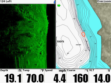
I finally got the loaner Humminbird 1197c SI installed on Li’l Gizmo, and am pretty darn impressed with its side scanning abilities. But before I get into that, check out that hi res map of my local Lake Megunticook. Yes sirree, Navionics recently updated their Premium and Platinum Hot Maps to include the data I helped collect one crazy day last fall. Frankly, the Megunticook map came out better than I expected. I know how fast the surveyors crisscrossed spots like this, and how far apart their tracks were, but I’ve sonared a few miles of lake bottom right alongside the new map, and have yet to encounter a serious surprise (though I’m doubting that particular ‘HAZARD’ warning on the screen above). Going from the old sketch chart to plotting on this level of detail is a giant leap in situational awareness (and possibly fishing success), and adding the side scan view is another big step…
But it takes a while to understand side imaging, and I’m still learning. I think this particular screen (below) helps. Li’l Gizmo is at the top in 16 feet of water, with the very narrow dual beam transom transducer painting the latest details top left and right. About 30 feet astern, and a few seconds back in time, I passed directly over a fair size rock sticking up in about 14 feet of water. I know the water was shallower back there because the doubled black water column is narrower. Are you with me? (If not, Google “Humminbird side image” for useful sites like this.)
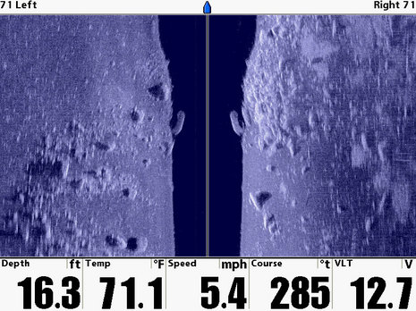
Lots of factors affect the resolution of the side image. Of course, boat speed is one; the faster you go the more bottom you’re trying to image with the same number of pixels (and the more it’s apt to be fuzzed by prop wash). But the 1197c does let you control chart scroll speed (the faster, the more detail, but less area shown) as well as how far out to show (again, more detail but less coverage). Plus there are sensitivity and sharpness settings, and if you turn much it naturally distorts the image you’re creating scan by scan.
At any rate, I did see Lake Megunticook bottom structure much better than I ever have with a conventional fishfinder, and I’m sure something really interesting like an old car (driving on ice can be hazardous 😉 or boat would have stood out nicely. I was also pleasantly surprised by how forgiving the side scanning was about boat pitch and roll, prop wash, and even nearby transducers. But, in fact, the lake bottom is kind of dull (unless you were looking for a lunker bass that might be hanging out under that boulder). Wait until you see how the 1197c can image the mooring blocks and chains in Camden Harbor; it might just blow your mind, as it did the Harbor Master’s!
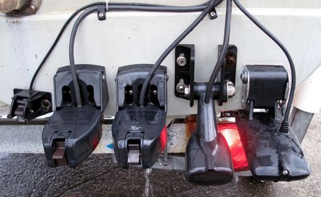
 I’ll put up lots of harbor screens tomorrow, but thought you might enjoy a look at the Humminbird side image transducer mounted on the stern of Li’l Gizmo. That’s it on the right, next to the Lowrance pinger that feeds the HDS, and then two Airmar P58s, one for an Interphase Chart Master Pro I’m also testing, the other for the boat’s own and test Raymarines. (The water speed sensor is Lowrance’s.) I don’t think these are all suppossed to work at once, but, as before, they seem to.
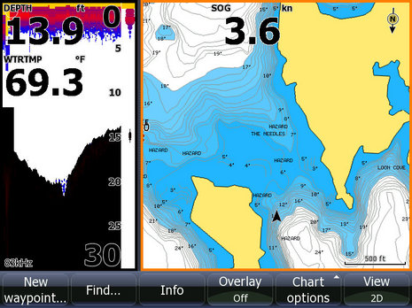
 And, finally, here’s a screen showing the new Navionics Megunticook map on the Lowrance HDS 10. I’m tickled that I helped collect the data, and am convinced that one day any one of us will be able to.


Pull that trailer at night, Ben, you could be arrested for data pollution with all those sensors.
Wow Ben, how does Gizmo even get on plane with that much hardware off the back 🙂
Good write up!
Another ‘Sonar Head’ I see. Thanks for all the great info.
Regards
John
Ran across this randomly in a search, from just over 10.5 years ago… how times have changed? (Lowrance Genesis mapping, shared sonar chart updates to Navionics, etc)… Just thought it was an interesting “look back” at the comments like you mentioned “seems someday any of us should be able to”… wasn’t too many years later!
Timely that you found this old entry, Chris, as I’m now testing a Humminbird Solix 10 with three side-scanning frequencies and real-time auto depth and bottom hardness/vegetation chart-making… pretty amazing:
https://humminbird.johnsonoutdoors.com/fish-finders/solix/solix-10-chirp-mega-si-g2