
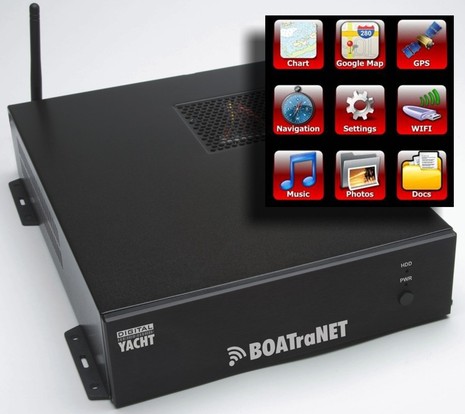
Interesting! Digital Yacht’s BOATraNET — just being introduced at the London Boat Show — is a low-amperage 12v Linux server designed expressly to deliver all sorts of NMEA 0183 and/or 2000 boat data, plus centrally stored info and media, via WiFi to whatever assemblage of smart phones, tablets, and PCs are on board your boat. And you won’t need a special app but rather just a new generation browser running HTML 5. You can also connect a high power WiFi transceiver to BOATraNET so that all your devices can get online via the boat’s own hot spot when you’re in port. Can anyone argue with Digital Yacht’s characterization of this concept as “revolutionary”?…
But I’m sure that such an unusual product will draw lots of questions, and I already have several myself. For instance, will a boat’s data be available to third party charting apps or programs running on devices connected to its BOATraNET? How complete is the built-in “Navionics based chart plotter”? Is it possible to access the server from off the boat using the external WiFi connection (for monitoring and security)? Can that external WiFi device be a third party Ethernet device instead of
the Digital Yacht WL500? How hard is it to load “photos, documents, music etc.” onto the server, and what about video? What are the capabilities of the optional NMEA 2000 gateway? And, by the way, how well can an HTML 5 browser do plotting and instrument displays anyway?
The best information on BOATraNET I’ve found so far is from the DY 2011 catalog
you can download here, and excerpted below. But maybe a Panbo reader will have take a closer look at
the London show, which runs through the weekend, and I’ll certainly visit the DY booth at the Miami show coming soon. I have, in fact, already spoken a bit with DY and understand that the base version with two NMEA 0183 ports will ship before April 1 for $849. I also know that they are quite excited about their creation and, while they don’t view it as a primary navigation system, they do think it can serve all sorts of onboard purposes in an easy, powerful way. Plus, as the press release notes, “th
e beauty of the platform is that it is very flexible” and DY “promises a host of additional data for 2011 including weather, chart updates and marine news.” What do you think?
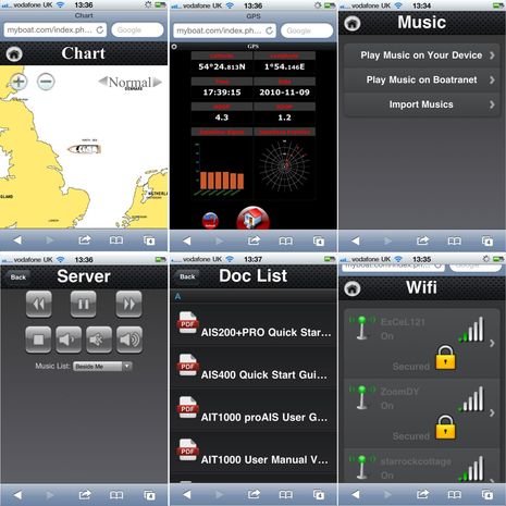
PS Cool! Panbo reader Richard Brain went to the Digital Yacht booth in London, logged on to BOATraNET with Safari on his iPhone, and took the screen shots below. As shown he tried streaming music, as well as the external WiFi, and he comments “Overall I think the charting functionality needs some more work, as it does not seem to automatically pan and the redraw seems to a bit painful (I guess they need to add JSON). Though this product is still in development.” Thanks, Richard!


Not an outrageous price for a marinized server with wifi. HTML5 is not a stumbling point for PCs, but may be in the case of data phones and tablets. It remains to be seen how well it can integrate with present chartplotters or MFDs. I’m assuming that the selection of HTML5 was drivien by its geolocation feature, which is not necessarily available in all HTML5 browsers.
I think it is a good idea. I have similar hardware on my boat that serves as a data logger and processor, and the local wireless access point. For my real job I spent New Year’s Day doing my first HTML5 data display. So far it seems decent, but I have not tried real time data display yet. One interesting feature in HTML5 is WebSocket that provides a low latency, long lived, connection for data transfer. I will be testing this to compare it with multicasting of my N2K data. WebSocket seems to only work in Chrome so far though.
Jon
Sandy,
I’m not aware of any relationship of geolocation and HTML5.
I’ve developed my own data displays over a year ago, and have sailed with them most of the year. Here’s a link to the sort of displays I’ve got going:
http://yachtelectronics.blogspot.com/2010/09/canboat-design-part-i-simple-data.html
The best feature in HTML5 as far as data displays goes is Canvas, which allows you to create graphs and analog views such as dials fully on the client using a bit of Javascript.
The basic approach is that you use AJAX that retrieves JSON data from the server (which will be like
see http://dev.w3.org/geo/api/spec-source.html
Geolocation is an API in HTML5, it draws from a number of different sources varying from your zipcode or IP address location to more precise sources.
Cool, I wasn’t aware of that.
I still don’t think that this product uses it, as it says “any HTML5 client” will be usable. On a boat the geolocation API won’t work unless there is a GPS in the client. Not enough Wifi or cell towers around to triangulate your position when you’re offshore 🙂
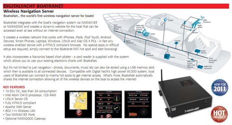
Hi Ben (and all) this is Paul from Digital Yacht.
Boatranet is intended to be an interesting and fun add-on to any existing integrated navigation system be it from; Raymarine, Garmin, Furuno, Navico, etc. It is in no way intended to replace these systems but instead enhances and “e-nables” them.
The owner/skipper/navigator will continue to do all navigation on the integrated system but for friends, relatives, crew or in fact any visitor on the boat, Boatranet provides a fun and interesting way to understand where they are, where they are going and generally what is happening on the boat.
Anyone with a wireless device that has a modern HTML5 Compliant browser will be able to connect to the WLAN that Boatranet creates (even way out at sea) and then start to browse the dynamic web pages that Boatranet creates. A simple Navionics based chart display (showing the boat, next waypoint and AIS targets), digital and analogue instrument displays, GPS status and rolling road type pages will be created.
Once the boat arrives in the marina, anyone connected to Boatranet will be able to scan all of the available wirless hotspots detected by one of our long range wifi adaptors, select one and connect to it. Once connected everyone on the boat will be able to share this internet connection.
Finally Boatranet can also be a receptical for all of the owners media files, initially; Audio, Photo and PDF files. Everyone connected to Boatranet will be able to play the music locally on their device (streaming) or out of the Boatranet audio out socket, browse and view photos or display/read PDF documents that the owner has loaded on to Boatranet via USB memory stick.
There are many, many features and functions that could be added to Boatranet but for first release our focus will be on 4-5 key features. From then on a regular bi-annual software release schedule will ensure that Boatranet owners will be leading the way in terms of new and fun wireless boat technology.
I would be interested to know if there will be an app to display the N2K data? And what sensors and PGNs it handles?
I have learned the hardware that Maretron, Actisense, Airmar, and other peices do not play well.
Here’s a BOATraNET video that shows it running a bit on an iPad: http://www.digitalyacht.co.uk/newsdesk_info.php?newsdesk_id=18
So, Paul, could iNavX running on that same iPad access the Boatranet data (like it can with your iAIS product)?
Readers should also check out SWAP: Ship to ship and ship to shore Wireless Access Protocol that has been use with US Research Ships.
– http://www.sssg.whoi.edu/swap2/
– http://sssg1.whoi.edu/oswap/swap-faq.html
Boatranet uses a number of the latest HTML 5 functions but we do not intend to use the Geo-Location API.
As for Boatranet producing a wireless TCP/IP feed for iNavX or other systems like our iAIS, this is not intended for first release but will almost certainly be added in the future.
Thanks to Richard Brain, I just added screen shots of BOATraNET taken live at the London show (though the data is apparently simulated in the server as I guess it’s not hooked up to sensors).
Digital Yacht has put up three videos explaining Boatranet, part 1 here:
http://www.youtube.com/watch?v=XLGEIHvizt0
I would love to mirror data from my cockpit instruments down below on my iPad. Wind, log, gps etc. Any more follow-up on using BoatraNet to format NMEA 0183 or n2k data to send over the boats Wi-Fi?
Is it possible to bring together a Navico broadband radar with a Raymarine display or just to an ipad? That would be interesting and eliminate a cost of implementation for the new 3G/4G radars when we have non-navico displays
Thanks.