
MIBS #3: Fugawi, Rose Point, MapTech, & Nobeltec Trident
I sense that PC-based navigation is about to enjoy a renaissance after a long period during which rapidly-advancing MFDs stole its thunder. I can think of several reasons (and you may have more): Decent performance PCs have gotten less expensive and tougher; NMEA 2000 can feed them more data, more easily (thanks in large part to Actisense); the various mobile platforms so many of us want to fool with on board usually relate well to the less mobile platforms that can also work well on many boats; and, finally, MaxSea and Furuno are showing everyone how powerfully a PC can fit into high-end marine electronics systems. One company that will participate in this renaissance, I’m pretty sure, is Fugawi…
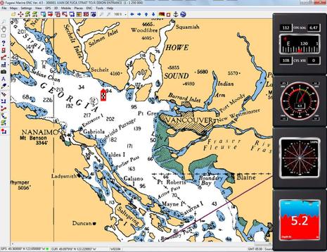
While I find the interface to Fugawi’s flagship Marine ENC charting program rather clunky, I’m told that’s going to change, and there’s no denying the modern power (and high value) behind the antiquated interface. In fact, it seems that Fugawi has devoted a lot of its resources in recent years to innovations like X-Traverse and partnership projects like Navionics NavPlanner2. Apparently its development team was also doing lots of contract work outside the boating world — a strategy many smaller marine electronics companies have gone with during the hard times — but that’s changing too.
Longtime Fugawi President (and sharp guy) Robin Martel recently became its owner, and he’s focused on taking the marine product line to the next level. As seen above, for instance, Fugawi ENC recently got integration with Avia Motor and Sail instrumentation software (discussed here in its infancy), which Fugawi also distributes as a standalone product along with compatible Actisense hardware. But the really tantalizing news that Robin shared is that Fugawi is involved in two significant partnership projects with major marine hardware companies and that while the direct results will be interesting, the deals also mean that future Fugawi products will benefit from the developement work. That’s all I know, but it sounds interesting!

But here’s the mood swing part: As the demo proceeded I was strongly reminded about how good TimeZero charting software is, and I’ve actually used it! (Though perhaps not on the ideal PC.) So if marketing TZ under a new, yet familiar brand helps raise awareness of what the MaxSea team created, that’s a good thing. And, besides, I understand that going forward the Nobeltec team will get to add further customization to the TZ core, and thus MS TZ and Trident will slowly grow apart. But when I get around to putting up some neat Time Zero screens I took on Gizmo l
ast fall — which I’ve tardy about — they’ll illustrate two software packages at once, at least for a while.


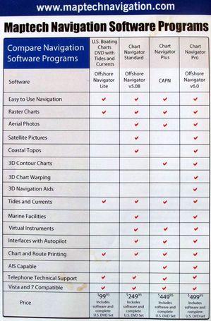
I take it that the new Maptech offering will not have tides and currents or any POI for the UK Ben, unless you have seen something different?
Steve
I don’t know, Steve, but doubt it. The 2011 brochure does say new updated UK & Ireland, Caribbean, Canadian, and Mediterranean chart packages with photos, 3D contour “and more.”
I am a member of the United States Power Squadrons, and I just signed up for our Navigator Course. Our Navigator course includes a copy of The Capn software and instructs how to use the software. I was shocked when I received my course materials and there were 19 discs in the package! I wryly joked that they need to discover this new technology called DVD. Then I realized they delivered me 19 DVD’s! OMG! I am glad they did not come on Blu-Ray, as I don’t have a Blu-Ray drive in my computer.
Its going to be fun learning CAPN in our course, I am looking forward to that software, and additional sextant work. It’s an exciting time to be a boater!
Hi Bob, The CAPN is a bit long in the tooth, but is still beloved by many, though some current users are quite anxious to see an updated version from the company that took it over a couple of years ago. A little (over optimistic) history here: http://goo.gl/F8mEg
Current home page, with forums: http://www.thecapn.com/
Longtime CAPN dealer and expert: http://www.sea-tech.com/
I recently heard that Star Tech has a new CAPN project manager and that things are looking up.
Not to change the subject to post-pc era navigation, or anything, but the iPad 2 demo this morning was killer.
I agree that iPad2 looks like a nice evolution. But I’ve been using all the iPad charting apps recently — while testing Bad Elf and Dual XGPS150 GPS accessories — and I don’t think any them is close to the PC nav programs mentioned above in terms of actual navigation or even planning.
So far both GPS gadgets work pretty well, by the way, and the Dual, which just came yesterday, also seems to be a “killer” product. There’s really no need to get a 3G iPad just for the GPS.
http://goo.gl/Y5Ex7
19 DVD’s? Good grief, skip the whole DVD and go right for using a PC, electronic maps, and ActiveCapain, or go back to methods that need no batteries at all. While i would lean towards the latter, the technology inbetween involving dvd’s stuff is the worst choice of the three to base a navigation class on.
Sorry, Dan, but I don’t understand where you’re getting a choice of three. One of those DVDs contains a PC charting program and electronic charts. The rest are extras like the whole U.S. coast in topo maps, photo maps, harbor photos and 3D contours; most boaters will only use a fraction of what’s there, but how hard is to squirrel a stack of DVDs away? Sure, there are programs nowadays that let you download some of these materials from the Web as needed, but then there are issues of what’s cached when you’re not online.
As for the paper chart option, you can see at the link below that the USPS Navigation course is quite a serious deal, and fundamental navigation skills are most definitely a prerequisite. I think it’s great that the Squadron is including an ECS component these days.
http://www.usps.org/national/eddept/n/main.htm
Unfortunately I can not choose which software our textbook teaches. I am always happy to be exposed to something new. I really want to keep learning the use of a Sextant from our courses. While a sextant is not practical to use for a weekend warrior like myself around the Lake Erie islands, it sure is fun to learn and fun to use! I have been using MacENC for my own practical navigation, and I really like that software. I use MacENC to lay out courses and GPS Babel to upload to my GPS.
Using a laptop while underway is not all that practical in my boat. I have a 30′ cruiser with an open helm. The sunlight will wash out the screen, and the laptop will not balance on the helm well at 28 knots! The laptop computers primary navigation function aboard my boat is pre-plotting courses (special emphasis on the “pre” part of plotting).
I have absolutely zero inside knowledge of what is going on at USPS national, but I have a feeling we might eventually move to Coastal Explorer with the N course. We used to give away a Maptech Chart Navigator CD with our (discontinued) Squadron Boating Course, which is very basic boating skills. Our new basic boating course is called ABC3, and I noticed that we were giving out a Rosepoint sample CD with that course. Unfortunately, I have not been able to nab a copy of the Rosepoint CD to see what is on it yet. I am guessing that it is some type of trial of Rosepoint CE.
USPS still seems to be the absolute best place for Navigation and boating skills. Our USPS University has been a big hit so far. Our piloting class teaches old skill paper chart skills, but once you have those concepts down, using the electronics becomes a piece of cake! Our Boat Operator Certification program is just getting off the ground and seems to be gaining some real traction. We just need to get the word out!
Yes Ben, the thought of Pigs flying over one’s head comes to mind.
S
If Robin Martel wants to shake the PC navigation software business to it’s core all he has to do is come through with his promises. He may not realize it, but he is in a field littered with disappointments and a lack of timely followthrough. No massive rewrite of your product is needed here, just tell us one thing you will improve or a benefit you will add to Fugawi and than introduce it on time and working and you will have accomplished what no other navigation software company has done before. The Capn has promised a new version for years and is now a non player, Rose Point has promised new hardware for use with Coastal Explorer for months and took forever to get radar overlay mainstream.
In this fast paced world of marine electronics you don’t have to announce new stuff a year ahead of time, we can get all hyped up to jump in about two weeks. And, that goes for you too Mr Garmin (with your fictitious 6208).
Richard C, you are probably correct with your marketing advice. Making empty promises without delivering always spell disaster. Promises that make us believe their products are actually vaporware. Instead, they should operate like Apple: where they release a new product (or product revision) with completely unannounced features, and its available today or next week.
> Instead, they should operate like Apple
Umm…you mean like the white iPhone 4? How come they can make a much larger white iPad 2. Seems sort of odd. For a company that generally makes/made everything in white and promised a white iPhone, think there might have been some issues with it that they didn’t consider?
Apple isn’t immune from delays and development issues. Their cleaning crew budget is larger than the sales from most navigation software companies. If anyone has the money to hit targets, it’s Apple. And they miss too.
This stuff is hard to develop and many navigation product developers take it pretty seriously since they know that safety is on the line with their products.
Got it in one Jeff, the iPhone/Pad is unlikely to be mission critical with lives at stake as nav software is. Phone manufacturers like Foxconn/Huawei/HTC can put anything out there, knowing that it can always be put right. The silly antenna modelling mistakes recently made by Apple, demonstrate that clearly. On the other hand one mistake may be just one too many as far as nav software is concerned.
Steve
I don’t really buy that, Steve; small mistakes in hyper mass consumer electronics like smart phones cost the manufacturers unbelievable amounts of money. Raymarine has several telecom veterans in their engineering and management staff nowadays, and I’ve chatted with them about the extraordinary processes required to ramp from beta to millions of units in a few months.
Plus I always laugh when anyone compares, say, Apple to marine electronics. I’m pretty sure that a single Apple product line — the iPads, six models with little differentiation — currently has gross sales for one MONTH equal to the ENTIRE global recreational marine electronics market — navigation, communications, etc. — for one YEAR.
Ok, I don’t know if this is the right place for this but I can’t restrain myself. I’m new in the marine electronic field but have been an IT guy all my professional life. I just refitted my 40’ with a brand new nmea2k network and started looking at chartplotter/MFD options available.
I’m all-in for PC based solutions. I don’t get why no one has really tried to make a marine PC at a reasonable price. We have excellent PC-Nav software: Hell, Vendee Globe and World record sailboats use NaxSea’s TZ on laptops (not Raym… type imbedded charting devices costing 3000$+). All that is missing is a bundled 12v pc, 12v flat screen and optional all weather 7″ touchscreen for remote (at the helm) operation at a reasonable price and I’m a buyer!
Once you have this setup and pop in a NMEA to USB gateway (such as actisense) well…and it’s a PC with: WiFi or 3G routers for internet access (or even 3G cell phone tethering if you are cheat on data plans), PC gaming, Skype phone calls, movies, USB TV/FM/AM tuner, huge music collection on disks, you name it…
Instead manufacturers seem to trying to make closed proprietary solutions dedicated to navigation. To me it sounds like lots of wasted R&D money compared to partnering with PC manufacturers for an open solution with fast market delivery time.
I’m sorry but I’m not a fan of iPads on a boat. It’s a fantastic device but as a serious navigation station…no. But hey, that’s personal, right!
Here are some incredible PCs at low price and power consumption. They could be a base platform for a great marine package:
Fit-PC3 (Dual core 1.6Ghz) 12v/18w
http://www.fit-pc.com/fit-pc3/
Fit-PC2 (Single 2Ghz) 12v/8w
http://www.fit-pc.com/web/fit-pc2/fit-pc2-specifications/
Trim-Slice at 12v/3w
http://www.fit-pc.com/trimslice/
And from our own Ben this, what seems to be the first, intelligent attempt at a bundled package, but somewhat closed (even if it looks to be windows behind).
CPN700i
https://panbo.com/archives/2010/12/standard_horizon_cpn_series_the_first_internet_mfds.html
All I’m missing is a reasonably priced 12v screens and/or touchscreens…anyone?
Yes I agree about scaling up design to production Ben, as I’m in the middle of that process right now and even on a small scale it’s difficult. Yes corporate risk is huge, but not worth lives, I was giving this a more humanitarian angle, with lives at stake under navigation S/W and instruments if mistakes are made. FWIW I also disagree strongly with Open Source development for Nav software, where nobody is really accountable for their actions or mistakes. Personally I think it should be banned by the IMO/IHO, but I’m not going to take on the internet now, am I.
Steve
Just a comment reguarding marine PCs. I work for a company that makes rugged mobile computers (Intermec) and it is an extremely challenging engineering exercize, and extra care is needed to manufacture. That, combined with the small market for such devices makes for what seems to be an expensive piece of hardware compared to mass produced consumer devices. Unfortunately for us sailors.
I have been using PC’s on boats since 1982–but it still eludes me why one needs a keyboard for navigation? A dedicated tablet device, with SSD drive, and track ball is much easier to operate in any craft–it can more easily be made waterproof….but there we are getting back to the MFD…. A computer has many uses on a boat, but not in a cockpit or open flying bridge. You want something which is simple to use. For example there are those who do not like the more menu driven Garmin than older units which had multiple buttons which were menu specific.
Down the line, I see more tablet type developement as the goal, rather than PC. The tablet will wireless communicate with all of the data input, and can go any where on the boat. Consider that for many years we had small displays mounted over our bunks (first Signet), that gave critical data when at anchor or underway. A wireless tablet in a bracket would do the same.
I totally agree, all I need is a MFD in the cockpit that will share radar with my PC navigation program. I need radar overlay displayed in both locations. I tried a so called waterproof, sunlight readable, $1000 display but it was not sunlight readable even under the dodger and from the look of the case I doubt it is waterproof in any way. This last link between MFD’s and PC is still, I think, a neglected market. I know about the limited attempts to bring radar to the PC via black box but linking radar and off the shelf MFD with any PC is still not available and the time for this is here.
I have stumbled accross a product “TRIDENT RADAR UNLOCK PACK (FOR FURUNO NAVNET)” at several online shops.
I guess this corresponds to “with the ability to integrate with both Furuno and Nobeltec hardware (for extra fees)” in the entry above.
This again raises the age old question: Does a Furuno MFD have to be present and powered up in order to use the Radar in Trident with this product installed/activated?
Does anyone know?
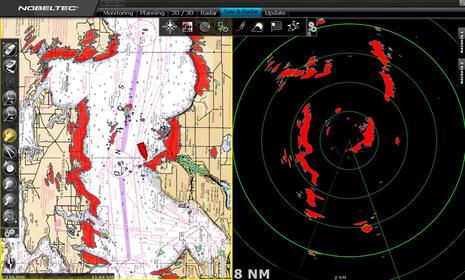
Yes, Henning, an NN3D MFD serves the radar to Trident TimeZero, just as with MSTZ. I’ve been using Trident with Furuno MFD12 and UHD19 radar this season (mentioned here: http://goo.gl/W4u9q ) and the combination is absolutely gorgeous, though quite expensive. I’ll write about in detail soon, but can say that you can leave the MFD in sleep mode and that Trident (and latest MSTZ) have lots more radar controls than earlier versions of MaxSea.
It’s also fairly easy to get Trident to use N2K data either direct from Actisense NGT1 or via NavNet, and also to mix in AIS coming in via 0183. I do think that Furuno & MaxSea/Nobeltec could open up an enthusiastic new market by permitting direct radar to PC connections, but I think they’re pretty committed to the current architecture.
And of course MSTZ or Trident will only work with Furuno or Nobeltec radars.
I am looking at switching to B&G electronics (IMO superior to Furuno, at least on a sailboat) but that means I won’t have radar overlay on MaxSea anymore. That little feature is so useful that I am even considering adding a Furuno radar to the B&G setup.
Expensive, more weight aloft, expensive, costly, did I say expensive already?
Well, there are always the Navico BR24 & 3G or Koden radars.
The Raymarine radars can also be displayed on their software
Well, but doesn’t using a BR24 straight to PC involve a license fee that’s nearly the equivalent of the hardware cost? I was really hoping that Navico would drop the license fee if one or more of their MFDs was on the boat, and while they’ve said that makes sense, they haven’t made it happen yet. I believe that sales of Navico gear and software like your Expedition and Coastal Explorer that can work with it would all benefit.
It looks to me like Koden radars are also hampered by some sort of extra fees somewhere in the supply chain, and RayTech was essentially mothballed in 2008 and doesn’t work with several current products or on some current operating systems. Of course that situation could change at any moment, or a player like Garmin or Navico, which have never had full on companion PC nav programs, could suddenly get one. Just saying.
Hi Ben,
Yes, the Navico licence cost does mean we only sell a few specialist licences.
Koden depends on which radar you use. The MDS-50R etc series require an interface box, but they also have a very nice solution (MDS-9) etc that Exp, Si-Tex etc can use that connects directly to the PC. Unfortunately, they don’t want to sell them through their normal channels I think. See http://www.si-tex.com/2009products_radarsensorseries.htm.
Ben and all – I really enjoyed the seven seas lecture and was surprised at how well the interface actually works – I understand that radar manufactures have generally figured out what radar “should” cost and what chart overlay should cost and they try to structures packages and license fees to reach those cost levels…
OK here is my issue – I need to replace the chart plotter on my flybridge and the radar repeater up there is dead (a furuno flat screen that feeds off the old style crt unit in the pilothouse which uses a large open array). The boat runs old nobeltec software off a laptop which drives a 19 inch monitor in PH. Radar is not integrated. So you see I have some buying to do – It has been suggested I just run a slave 15″ WP glareproof monitor up on FB and replace repeater (they are cheap) …this work is going to come close to the cost of an 8 inch nn3d unit which would allow me to run a small dome and by buying the new trident software I would have both excellent up close radar, good chart overlay and new nicer looking software. Second option is to buy coastal explorer (which I think I prefer, just a bit simpler) and their Koden dome – again still pretty cheap but would then need an mfd on flybrige (unless I ran a repeater screen up top and then I havent really “saved” any money…Im not disabling the old furuno radar – it works well…