
DeLorme inReach, hand’s on #1
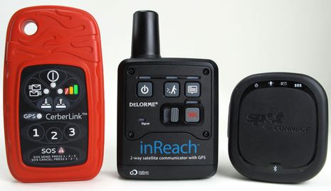
Click on this photo for a close look at the new age of satellite messaging, tracking, and distress handhelds, or at least three of the early contenders. I was cautiously keen on the DeLorme inReach when it first surfaced, but then I had to bite my tongue. Though I was experiencing its reasonably fast and affordable two-way global messaging back in August, I couldn’t discuss it because of the beta testing NDA. Fair enough, as the inReach system evolved substantially during the beta process. Plus I’ve now had a chance to compare it with the less expensive Spot Connect, whose one-way custom messaging via Globalstar was discussed here in January. Not to mention the pro-oriented BriarTek Cerberus system, which also appeared here last January and which uses the same Iridium 9602 data modem as the inReach. The news is pretty much all good for anyone who boats (or hikes, or whatever) beyond cell service, but it’s going to take several entries just to lay out what I’ve learned so far…
This entry is going to focus on inReach, but let’s start with what’s common to all three systems. At the center of each is a handheld device containing GPS, a Bluetooth radio, and a one- or two-way satellite data modem. The handheld alone can at least send your position and ID to a private SAR center — the GEOS bunker in Texas in all cases, I think. The two Iridium handhelds can also send tracking info and canned messages, quite like the regular SPOT. Owners of all three devices get a web portal where their messages and tracks are archived and where they can manage things like service subsciptions, canned messages and share pages (where friends and family can view a subset of what’s on the portal). And finally there are smart phone apps that use the Bluetooth connection for at least custom messaging and sometimes much more.
The DeLorme app — called Earthmate, and so far only available for Android — is definitely in the “much more” category. In fact, I’ve long thought of DeLorme as the mapping and handheld GPS developer most willing to put every possible control and feature into their products, sort of like Furuno is in the world of dedicated marine electronics. That’s not necessarily a mistaken stradegy, but it can lead to confusion among some users. I’d say that while Earthmate walks the line between power and ease of use pretty well, techy types will take to it quicker…
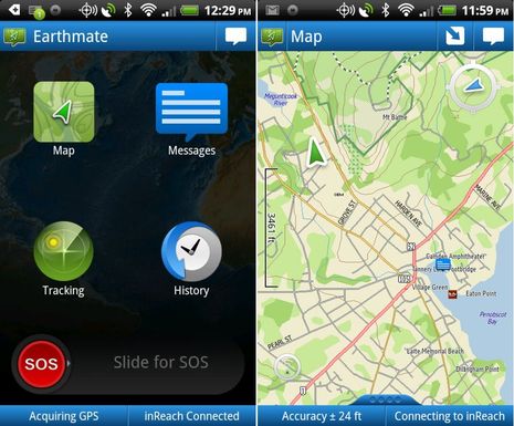
So let’s take a look behind Earthmate’s simple-looking main page. For one thing, this is the only satellite messenger app that includes mapping, and it’s serious mapping. You can download a 150 Mb world base map plus North American regions of DeLorme’s own high-detail topo-based cartography, at no extra charge beyond inReach hardware and service costs. There’s no charting yet, but note that DeLorme is a Navionics partner. And that you can view the maps north- or head-up, specify details like how the scale bar works, and your messages and track points are mapped along with your current position. Which could come in handy if you got lost in the wilderness, even if you were able to call out the SAR cavalry. Note that that the blue icon in Camden Harbor is where I posted a message to Twitter from Gizmo over the weekend. (Yes, the boat is still afloat, which is good as a Simrad 4G radar arrived at the door yesterday!)…
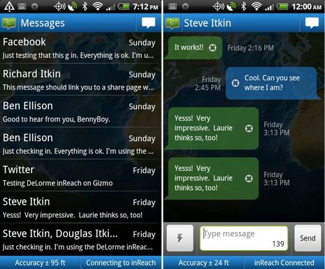
The screen at left above is what you get when you hit the Messages button and I think it needs some work as it doesn’t differentiate between incoming and outgoing texts (which is especially problematic for someone who emails himself ;-). However, when you drill down into a message thread, it’s more obvious what’s going on. And while I was just goofing with in-laws over the holiday, I don’t think I can overstate how revolutionary it feels to be doing nearly real time two-way texting on a Iridium device that by definition can work nearly anywhere on the planet and is not very expensive. Of course the inReach likes an open sky view, but I have successfully messaged and tracked from my office window (looking into a backyard full of trees and high topography) and also from the back seat of a van speeding north from the Portland airport. Incidentally, that “lightning” icon next to the “Type message” box lower right can pull up canned text snippets that you’ve entered on your DeLorme web portal and then synced with the phone when it was online. See what I mean about every possible feature?…
![]()
Above left is Earthmate’s main tracking menu. You can set the interval from 10 minutes to 4 hours, and the app is smart enough to lengthen the interval when the inReach is stationary. One thing I don’t understand yet is why the phone’s GPS is used instead of the inReach’s, but I do know that if you close down Earthmate, the tracking is swapped over to the inReach seamlessly. And if you start tracking on the inReach while it’s connected to Earthmate, the app hears about it. Note too how inReach and Earthmate send speed, altitude, and heading info along with position, though how the latter is determined when the devices are stationary remains another mystery to me. Also note the red exclamation sign on the left screen. Tapping on that brought up a dialog box explaining that the inReach had not been able to send off the track point — not surprising given its location — and giving me the choice of cancelling or trying again. That’s a sign of how much communication is happening between phone and inReach and also of an app that’s programmed to deal with difficulties.
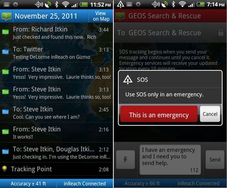
Below left is the screen two levels below the History button on Earthmate’s main menu. Here we have a day of activitiy with the incoming/outgoing icons the Message screen should have as well as track points, all of which can be queried and shown even with the map of where they took place (if you did the downloading). And, finally, there’s the initial SOS screen. Of course in some circumstances you might fire off SOS on the waterproof inReach itself, and I trust that would be effective largely due to the SEND standard discussed in June. But if, say, you got dismasted or blew your engine offshore and could still use the apps phone link, inReach would give you the ability to converse with GEOS and then the SAR agency they passed you to. That’s HUGH.
But does inReach perform flawlessly? I’m not sure. I do know I’ve had a few Bluetooth connect issues even since I got a production unit (and I admire any company willing to tech support Android Bluetooth issues). And I’ve also had a couple of instances where the inReach froze up and could only be shut down by removing the Lithium AA batteries. I’m talking to customer support and also watching DeLorme’s very active forums. But I’ve also witnessed how far the company has come with hard- and software in a few months and trust they will keep tweaking toward perfection. Then again I’ve also seen how differently — sometimes positively, sometime not — BriarTek designed Cerberus around the same Iridium module. Overall I still think that this is a terrific new communications technology. Tomorrow we’ll look at the Internet side of inReach — full featured to be sure — and I’m hoping some of you will help with further testing.


 versus Orion, plus a new option")


A few postscripts:
* There are more smarts to the SOS function than noted, like the fact that it sends position every minute for the first ten minutes and then slows down to conserve battery life.
* But I do seem to be burning up batteries in the production inReach. May be an anomaly, or may be a problem.
* Hey, after owning an Android phone for nearly 18 months I can finally take screen shots (without ‘rooting’ the phone). Progress!
Ben, any views on its use / performance as a standalone unit?
No problems I know of, Marius. Turning on tracking or sending one of the three pre-written messages is straight forward and the LEDs let you know that they’re getting to the Iridium system. Ditto for the SOS button, which we were able to try during the beta period.
At first I thought that Spot was a much better deal for constant tracking, but then DeLorme added unlimited tracking to their two higher cost service plans. It’s still more expensive, but you can switch plans according to monthly needs.
Ben
I was the land-based communications guy on this year’s NARC rally. Was last year too. Here’s my take on the trackers. I wrote this on my website (www.DHLyman.com) that carries a day by day report on the fleet as it departed Newport and made its way to Bermuda, or ran into TS Sean.
Many of the boats had SPOT Trackers, but they were far from what I’d call a professional, off shore tool.
Here’s what I wrote in my section on lessons learned from this year’s NARC:
Tracking. I bought a SPOT for our last trip in 2009. It didn’t work. I had a iBoat Tracker which did work–splendidly. It gave frequent updates, kept a record of our track, indicated average speed and course. We hove-to just south of the GS to fix the cables on the steering–that event showed up on our track. I threw the SPOT over the side. Tracking is now affordable and invaluable for the people following your course, especially anyone providing weather and routing information. They need to know where you are, and what your doing for boat speed and your course. SPOT does not provide this information. It is not practical for a fleet of ocean going yachts. The Carib 1500 is using YellowBrick.
You can still follow the track of our 2009 / 2010 voyage on the iBoat Tracker site, 2 years later. Here’s the link http://charthorizon.com/m/cz/map?vessels=Searcher&history=Bequia_-_Current_Position&v_scope=all
As far as the ability to send an emergency messages via a tracker, any boat going off shore needs a satphone or an SSB, or both, plus an EPIRB. Using a tracker to call for help in the middle of the ocean is not there yet. Programing these things can be a challenge. The iBoat Tracker comes pre-programed, all you do is sat it under the dodger and forget it.
David Lyman
Camden
Thanks, David, but I’m pretty sure the Carib 1500 did use Spot trackers, though the tracking was displayed on Yellowbrick’s portal. You can see that stated on the screen shot I published: http://goo.gl/PY1Tg
I also followed a boat from Newport to Norfolk to the BVI via Spot and it hardly ever missed a 10 minute point (just like last year), except when they forgot to turn it on after the 24 hour default period. You can see and even download the track here: http://goo.gl/xPfFq
I’m not saying that Spot is a “professional, off shore tool” but especially since they introduced the second version and replaced some of the satellites, it often works quite well. And it’s making a lot of boaters happy at $250 for whole package with a year’s service, or $200 if you forego the 10 minute tracking and just send a “we’re here” message every hour or watch change.
The new Iridium devices are not proven but they are quite different from Spot, and I’m dead sure they will impact the rubric that you must have sat phone, EPIRB, and SSB. I suggest you read Doug Ritter’s warning to COSPAS-SARSAT: http://goo.gl/QFhoa
I also strongly suspect that SENDs (Satellite Emergency Notification Devices) like the two Iridium-based units above will find a place in coastal cruising.
Change is the only constant.
We used a spot from Ft Lauderdale to Seattle last spring and it worked well without any problems.
It would have been nice to be able to change the ten minute track point interval to something slower – every ten minutes seemed a bit much at 6 to 8 knots for days at a time. Our work-around was to turn it on for an hour or so several times a day on the long legs.
Take a look at the subscription rate for Canada… I want the “Chat” or “Expedition” package offered for them! Also, I want this for the iPhone too.
This is what I have been waiting for.
Any idea when an iphone version will be available?
BriarTek’s Cerberus system has apps developed for iPhone, Android and BlackBerry. You don’t even need a CerberLink to use the system. You can download the iPhone app now to send messages, receive location based alerts and record breadcrumbs using your phone’s GPS at no cost.
http://itunes.apple.com/us/app/cerbertouch/id473790578?mt=8
Lew — who is the Cerberus Product Manager at BriarTek — is champing at the bit! But it is neat that people interested in these Iridium devices can check out the apps as available, and especially that CerberTouch has some use even without the hardware. As mentioned in the entry, the Cerberus system is interestingly different from the inReach system in several ways, which I will be covering soon.