
SailTimer; the app, the GPS, & the Wind Vane
It’s time to catch up on Dr. Craig Summers and his passion for Tacking Time to Destination (TTD). The basic idea is to calculate in advance how long it will take to tack (or jibe) a sailboat to point B in particular wind conditions, but there’s a lot to it. Like how does the software program or dedicated device know exactly what your particular boat can do those conditions — a set of performance values known as polars — as well as what the boat and wind are doing in real time so it can perfect its predictions? And what about currents? When we last discussed SailTimer in 2009, Summers had introduced a rudimentary iPhone app and was working on something called The Sailing GPS. The latter is real now, the app is several generations advanced, and that’s not all!
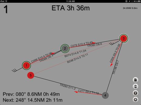
If you have an iPhone or iPad the easiest way to get a feel for Summers’ work is to install the free SailTimer Charts Edition app. That’s all I used to get the screen shot above, which suggests how long it would take an average 37-foot boat with 14 knots of ESE wind nearly on the nose to sail from my home to a waypoint I dropped off Nova Scotia. Sometimes the waypoint management seems a little twitchy but beyond that all I had to do was Input boat size and estimated wind speed/direction. Once the Optimal Route was (near instantly) calculated I could use the arrow tool seen lower left to flip first tacks and I could also tap on the route line to get that boxed detail on the individual legs. It’s only an approximation to be sure — and I would probably wait for a wind change anyway 😉 — but SailTimer has much more going on…
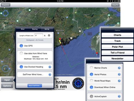
Click the screen above bigger and check out the Options Menu at the right. From within SailTimer you can not only purchase various chart packs but also a $10 module that let’s you use polars specific to your boat. You can also display your sailing route over satellite photos even in the free app and/or buy a $5 module that will overlay ActiveCaptain information. Now look to the left at the Input Set Up menu. It’s no surprise that you can use GPS (the Bad Elf Pro Bluetooth model works great) to track your vessel and display/collect SOG/COG data, but how about a SailTimer Wind Vane system that not only connects wirelessly to your iThing but also reports its battery state to the app?…
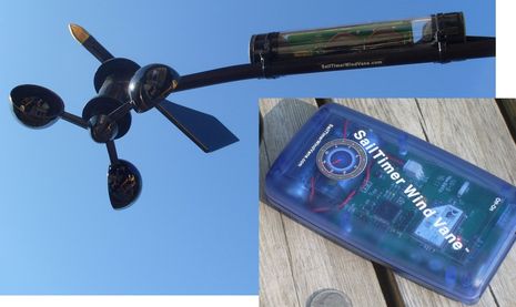
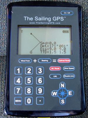
Yup, the $689 SailTimer Wind Vane is a solar-powered sensor that can purportedly reach as far as 300 cable-free feet to its little blue battery-powered base station, where the data is turned into NMEA 0183 formatted Wind messages and sent out again over WiFi. There’s also a Bluetooth version that can be used with certain phones that don’t have WiFi as well as with The Sailing GPS ($399) seen on my truck seat below. I didn’t get to go sailing with the test unit, but it did seem capable of doing the same TTD calculations as the SailTimer app. And I haven’t mentioned yet that either can be used to build custom polar tables if wind data is available.
Probably the best place to dig deeper into Craig Summers’ world of TTD predictions is at the SailTimer app site but also note that I passed the loaner Sailing GPS over to Dan Corcoran, who not only did some realistic testing with it last summer but also tried the wireless wind vane and the app. Apparently Dan wasn’t very impressed, but then again he’s often quick to see what’s not in a product and he takes his instrumentation very seriously. Which, incidentally, may have something to do with why he and his crew were recently awarded the Allegra Knapp Mertz Memorial Trophy for overall racing performance of a non-spinnaker sailing yacht with a PHRF handicap of 139 or higher across the 63 member yacht clubs in the Yacht Racing Association of Long Island Sound. Big congratulations to Dan and I’m sure we’ll hear his views on the current SailTimer product line in the comments section…
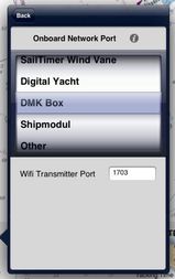
Heck, maybe Dan will write an entry about some of the other apps that attempt to do TTD style calculations and where he’d like to see the technology go. And Dr. Summers certainly isn’t done yet. For instance, I was pleased to hear that he’s working with companies like Digital Yacht and DMK who are developing hardware that can put a boat’s NMEA 0183 or 2000 wind, GPS, depth, etc. onto WiFi, as shown in that beta SailTimer “Onboard Network” menu at right.
That means means a sailor will be able to get the full benefit of SailTimer without the specialized hardware, and that the same sailor can try other apps that may try to accomplish similar goals.
But they might run into SailTimer elsewhere, too. For years now, Summers has licensed his algorithms for use in programs like MacENC and Fugawi (I’m about to test the all new Fugawi 5 edition) and that also happened recently with RudderNut’s Tack Pad app. If you already have an iThing, Tack Pad is also free and it’s a neat example of a very different approach to the complex calculations that SailTimer does. For instance, those values at bottom left below change as you finger drag an orange waypoint around and you can also set wind speed and direction for each waypoint with your finger. I’m not entirely comfortable with the fact that Dr. Summers has claimed trademark on TTD — it seems like an obvious term and acronym to me — and has also patented algorithms that may be obvious to some programmers, but I certainly admire his persistence about making the world more aware of Tacking Time to Destination.


Looking forward to the comments, particularly about the SailTimer wind vane, as I seriously considered buying one (before deciding that it looked a little too home-brew for $700, and that maybe I would be better off waiting for a review).
I am craving the ability to auto-generate custom polars. I am hoping that this functionality gets better over time. We shall see.
Also, why the hell doesn’t the Tacktick wind-vane come with (or at least be compatible with) this technology? Seems like a no-brainer.
Hi, this is an interesting thread and you might want to also have a look at our iPolar IOS app availabe on iPhones and iPads. It is a very simple polar generation tool, based on a set of 81 proper VPPs which we have run. Then we can interpolate fairly accurately the polars of production yachts within 24ft to 60ft.
http://www.sailingperformance.com/iPolar.html
The Sailtimer Charts Edition App appears to be only available to US residents. Why is this?
Krist, The SailTimer app ($13.99 US) is available worldwide and can display charts, but the Charts Edition of the app is only available in countries where hydrographic charts are available: UK, USA, Canada, Puerto Rico & US Virgin Islands, The Bahamas and Cuba.
I have some feedback from some testing on Long Island Sound this summer.
All three applications will provide a sailor the time to destination (TTD) to an upwind destination along with the automobile GPS equivalent of turn by turn instructions to get you their (assuming open water) including the fastest course to steer and the distance and time of 2 or more legs to reach your destination. Then it’s up to you to watch your sail trim and keep your speed up.
Each of these applications requires some work on the part of the user to get good results.
If your just looking for a back of the napkin TTD and want to disregard the course to steer, these products will do that pretty well.
If you’re looking for these products to give you a useful course to steer, a continuous readout as you make progress, or help prevent you from making a bad turn (ever tack and be completely surprised at your new heading ?), you will need to work for it, and it will help to have a really good source for wind relative to ground or the talent to guess that to say +/- 10%.
Enough talk. Below is an overall comparison based on sailing on Long Island Sound. Note how the three applications couldn’t be more different from each other.
— RudderNut —(the last application pictured above)
Best overall solution calculator, but only if your anchored. Underway in a bouncing sailboat it was tough to use.
GOOD: 1. RudderNut is the only application that allows you to enter set & drift, a must have when the current is strong, as it is 66% of the time on Long Island Sound. 2. You can compare two options to evaluate the best. 3. You can enter many waypoints, even for a circular course. 4. Great learning tool to experiment with cause and effect of forces of a sailboat.
BAD: 1. The touch screen interface is exceeding difficult to use in direct or indirect sunlight. Entering wind or current vectors requires you watch the numbers spin as you move your finger across the screen, very hard to do on an iPad display washed out in sunlight. SailTimer did this better.
Core Features = includes set & drift in TTD math, compare two solutions with each other
— SailingGPS —
Best overall solution calculator if your underway. As opposed to iPad app, this product is a standalone navigation tool with a sunlight readable display.
GOOD 1. Superb user interface, is great in sunlight on a moving boat. 2. Waterproof 3. Utilizes GPS to update progress, so recalculation is a snap.
BAD: 1. Cannot enter set & drift, a limitation when sailing in current 2. Underway, asks for wind information you may not have depending on your boat instrumentation.
Core Features = Superb GUI for open cockpit, quick to input needed information and get a result. Utilizes GPS to update progress.
— SailTimer —
The most feature rich of the three, it now is available with a nautical map as part of the user interface. Lots of features.
GOOD: 1. The user interface is much easier to use in sunlight than RudderNut. 2. Automatic update as your boat is making progress, on a moving map. 3. User can roughly see how close the calculated solution will bring them to land obstacles. 4. I did not evaluate with the wind vane together, but it has me excited at the possibility the user need not enter or update wind information.
BAD: 1. Cannot enter set & drift 2. Underway, asks for wind information you may not have depending on your boat instrumentation.
Core Features = Utilizes GPS to update position, moving nautical map, integration with wind vane, many other features.
— Conclusion —
As Ben wrote, I was not impressed. These applications rely upon knowing the wind direction relative to ground (equivalent of boat at anchor) and expect the user to provide that. Problem is, that our instruments don’t provide a good approximate wind direction relative to ground when under sail. Powerboats maybe, but not so much sailboats. Since these products are already doing a lot of math on a speedy iPad, I would think for a moving boat a better approach would be to ask the user for information they have from boat instruments like apparent wind, heading, speed thru water. Then, using some math, the built in GPS, and some additional correction tables for wind measurement errors and leeway, calculate set and drift, and arrive at the ground wind direction without asking the user. Instead, I had to do that work myself.
Understanding how the math works and comparing it with the real world, it seemed that big errors in wind direction +/- 30 degrees didn’t much matter with calculating TTD as long as your destination is in-between the rhumb lines, but inaccuracy has a big effect on the turn by turn instruction capability of these applications, the ability to estimate your new course when you tack from your current course, and other advanced functions.
“If you’re looking for these products to give you a useful course to steer…”
Thanks, Dan, but I’d be surprised if any sailor expected accurate Course to Steer (to windward) from TTD calculations, and it makes me wonder if you have set impossible expectations for these products.
I haven’t done much sailing for a long time but I once did a whole lot, often without any instrumentation, GPS, etc. This I know: when a boat starts tacking to windward, almost the entire navigation process inverts. Instead of the navigator telling the helm a course to steer to stay in safe water and reach the destination, the driver tells the navigator what course he or she is able to steer for best performance and the navigation problem becomes when to tack to accomplish the destination and safety goals.
I don’t see how any sensors or algorithms have changed this essential situation because the key variable remains the same: The course of a sailboat hard on the wind is entirely dependent on shifts of wind speed and direction.
Maybe I missed something, but I don’t think SailTimer claims to offer “turn by turn instructions” which I wouldn’t expect anyway. As I understand it the intent of TTD is a sailboat specific form of ETA, as in ESTIMATED Time of Arrival.
So I think SailTimer and Tack Pad are primarily planning and reference tools. And if they can update their predictions based on real time sensor input, that’s great but the results are still estimations because there is no way to predict future wind changes. I agree that factoring in tidal currents would be nice but they are difficult to measure in real time and the predictions are not often accurate or comprehensive.
Dan, could it be that you’re expecting something impossible from SailTimer? Also, did you try using custom polars and/or using SailTimer to build polars? Again these are only estimates of how fast a particular boat can in go at specific apparent wind angles and speeds, but they should be able to improve TTD estimations.
I just want to confirm that Dan did NOT use the SailTimer windvane?
To me, the windvane (if it works) would add an incredible amount of additional functionality (and the “turn by turn”, or “tack by tack” feature that would mentioned.
My concern was that it only sampled wind speed/direction ever 5 seconds, which could give a “laggy” response time that may be frustrating to impatient people like me.
Would also love to hear from someone who has tried the custom polars feature.
I guess I have a different viewpoint from Dan C. I sail primarily on Lake Michigan, and I find using the SailTimer app very easy. And if I can someday input my on-board data (wind speed & direction, boat speed) into SailTimer wirelessly, it will be even easier. As it is now, the SailTimer wind vane will provide the necessary wind input, and if a person just selects a waypoint, the green lines show the optimal tacks. It’s pretty un-complicated! As the wind changes, the optimal tacks and TTD update automatically, and if needed/desired, the wind direction can be changed manually in the app to see the new optimal tacks move correspondingly. But I agree with Ben…this is an estimate…having said that, the fact that the app keeps updating with real-time information makes that estimate more reliable.
When sailing, it is also reassuring that what I see in the app for the wind direction, boat heading and optimal tacks corresponds to what I am experiencing first-hand. So Dan’s comment about wind direction is a bit confusing to me. “Wind direction relative to ground” seems to refer to True Wind direction.
Dan, are you criticizing ALL anemometers, saying that no anemometer on a moving boat can ever get a reasonably accurate measure of the True Wind direction and speed? I think every marine electronics manufacturer would disagree with that, since every chartplotter, autopilot or navigation system I have ever had displayed what it considered “True Wind”, and relied on that information for its calculations.
Even if “True Wind” has some inaccuracy, the amount of discrepancy in the TTD that SailTimer calculates for arrival time based on True Wind is still far less than with standard ETA based on SOG or VMG to the mark. I think it’s important to note that these products seem to be the first to recognize that calculation of ETA for a sailboat is different from ETA calculations for power boats. I struggled for almost two years, as a customer, trying to make the software engineers at Nobeltec/Jeppesen understand that sailors needed something different from power boaters, but my requests fell on apparently deaf or unwilling ears. So it’s refreshing for me to see the innovation offered by these products. As far as I know, the major manufacturers are still producing standard GPS chartplotters using methods designed for aircraft, vehicles and powerboats that assume you try to travel in a straight line to your destination (which is obviously not true in sailing). They don’t account for the distance a sailboat has to tack upwind. If they don’t know how far my boat is actually going to travel, in my opinion they should offer a “Sail-Only” mode, in which ETA is not even an option.
So Dan says he’s not impressed, but I can’t find much that he criticizes, other than the lack of ability to account for set and drift, and the hypothetical inaccuracy of True Wind. From my standpoint, it seems that these innovative new products provide a significant improvement in calculating an ETA for sailboat navigation.
I was also a little confused by Dan’s comment about being “between the rhumb lines”. As far as I know, from a given starting point to a given destination, there is only one “rhumb line”.
I should say that I have no affiliation with any marine products manufacturer…I’m just a retired orthodontist and an avid sailor. I’ve not posted here much prior to this, and I don’t know the background or affiliation of those who make comments (nor, I guess, is there any way to ever know that) but it strikes me that it would be useful to include in our posts whether or not the author has any marine industry affiliations or support…as someone once said about statements on issues “Tell me where you sit, so I can better interpret where you stand!” Sort of like the “analysts” on CNBC who divulge their connections (or lack thereof) to stocks they are reviewing.
Thanks, Jon. Panbo definitely has a policy about comments from marine electronics manufacturers, though I should make it more accessible:
“It’s fine for manufacturers to comment on entries about their own or other products, but please state your affiliation, even if you don’t use your name.”
https://panbo.com/archives/2011/04/panbo_surveys_comments_paris.html
I’m the author of Tack Pad, and just wanted to point out that I had never intended the app to be used while underway. I use it mainly for passage planning, from the relative safety of my chart table. Having some support for using the app underway would be interesting, but really this sort of functionality should be part of every chart plotter so I don’t see a big future for this sort of app (unless I want to compete with iNavX, Garmin, Navionics, etc..)
I agree with the comments that you have to consume these ETA’s with a large grain of salt. Still it’s a starting point, and definitely better than a straight line estimate.
Which brings me to Ben’s comments on patents. I came up with this algorithm on my own and ran into Dr. Summer’s patent after the app was done. It’s a brute force approach to standard navigation calculations which I would not think patentable. Though I disapprove of the patent, there’s not much I can do about it, at least not easily. Dr. Summers has been great to work with though, and kind enough to grant me a license under reasonable terms. So I guess it could be worst 🙂
With all due respect, even Panbo personnel may want to consider making “full disclosure” statements sometimes, not just manufacturers contributing comments, since Panbo is itself sponsored by sailing magazines that receive revenue from major electronics manufacturers. (Like the CNBC journalists do, as noted in a comment above.)
Those sailors interested in the TTD approach might also consider looking at the ‘Sail Cruiser’ software from NavSim. I purchased this a number of years ago -admittedly because I like C-Map cartography and was after a PC nav program that used them, and have been generally happy with the program and also the accuracy of the TTD predictions it generates. As a fully integrated program Sail Cruiser will utilize your polars and realtime wind/instrument data in making it’s projections (I cannot vouch for set/drift even though they are displayed).
Interestingly, Ben alluded to Rob’s comment, when he mentioned previously “But they might run into SailTimer elsewhere, too. For years now, Summers has licensed his algorithms for use in programs like MacENC and Fugawi (I’m about to test the all new Fugawi 5 edition) and that also happened recently with RudderNut’s Tack Pad app.” He inadvertently neglected to mention that the SailTimer algorithms are also licensed to NavSim, but the difference I see (I run SailCruiser aboard Indigo and have been very pleased with it) is that SailCruiser, while calculating TTD, does not incorporate Polar Learning, as the SailTimer app now does. Maybe that capability will come along in a future SailCruiser release, but for now, it’s nice to have SailTimer do that heavy lifting effortlessly.
Thanks, Rob & Jon. I messed up the license references. I thought that NavSim had stopped supporting Sail Cruiser but in fact they’ve just moved the recreational programs to a new site: http://www.navsim.pl/index.php?lang=en Also, it turns that while Fugawi does license SailTimer it doesn’t yet use it in Fugawi Marine software.
Journ, I’m quite willing to “disclose” my financial affiliations but I don’t think there’s anything that’s not obvious. I get paid by Bonnier Marine Group for their sponsorship status on Panbo as well the right to republish Panbo content on their magazine web sites. (I also do technical editing for those magazines and occasionally write original pieces).
Of course another source of Panbo income is its advertisers. I really appreciate them but feel that my only obligation to them is to produce regular and lively content so readers come and see their ads. I guarantee you that no one tells me what to write here and actually I very rarely get complaints about what I do post from any of the manufacturers involved, including advertisers.
Tim, Thank you for commenting. I’ve been looking into another marine-related patent issue that unfortunately hasn’t been resolved as smoothly as your’s, and I will write about it soon.
Ben, my post was probably a littler harsher than I intended regarding Summer’s TTD patent, but there certainly are lots of patent horror stories around. Since I make a living off IP content (software, games, etc.) I’ll be interested in reading your patent story 🙂
I’ve looked at the NavSim software website and the features look great, hopefully we’ll see more integration and use of TTD, and better piloting support for sailors. There’s been a lot of focus on weather routing, which is great out in the ocean, but not so good for coastal navigation. Another sailing app that looks interesting is iRegatta. It’s geared towards racing, but does provide some similar information, tacking angles, speed and lay lines from polars, etc.
I mentioned earlier that I don’t see a whole lot of future for these small navigation apps but I’m having some second thoughts on that. One thing that’s hard to miss is that none of the big manufacturers offer tablet software that can be used for navigation. All are designed to only provide features useful for planing and/or to complement their chart plotter or gps hardware business. In other words none are designed to compete with their hardware. INavX is probably the only serious navigation/chart-plotter for tablets. Garmin’s blue chart app is a good example, some great features, but you can’t actually use it to go anywhere. It’s not like the few extra navigation features are hard to add. This lack of navigation functionality has nothing to do with the capability of the tablets and is purely to protect their hardware sales (or in Navionics case, probably royalties from chart plotter sales). I don’t mean to imply the marine industry is “bad”, they’re are simply protecting their higher margin hardware . Anyone in their position would do the same, but it does mean there is some opportunity for others.
Tim, I’ve been looking at the new nav module Navionics recently started offering and it seems pretty powerful. Some details at i-marineapps:
http://tinyurl.com/i-marineapps-Navionics
I think that we’re going to see all sorts of interesting apps as the data standards and boat-to-WiFi pipelines get sorted out, and also as the marine electronics companies use mobile devices to add value to their dedicated gear.
What I don’t see, though, is radar and sonar becoming commodity sensors that can interface directly to apps. Dedicated MFD-centered systems may be expensive but so is all the developement, manufacturing, and support behind them.
At any rate, for many of us apps will never be primary nav tools without radar and sonar.
We live in interesting times, don’t we? Now you can get more advanced sailboat navigation results on a low-cost app for your phone than with an expensive GPS chartplotter. How fast things have changed, with the rapid worldwide growth of mobile devices and apps, in just a few years.
At the same time, manufacturing is declining in Western countries, so we need knowledge-based (i.e. digital) innovation to facilitate economic growth. Hopefully we live in a society that still values and protects innovation and Intellectual Property. I thought it may be useful to respond to the negative comments about patents and trademarks above. This isn’t the place for a philosophical debate about such things, so this may be my only comment on that topic — but I didn’t want my silence to suggest agreement. This is meant in a friendly and constructive spirit, although these messages may sound abrupt sometimes because they are succinct.
I was a bit surprised to see the review stray from product features to conclude with somewhat political or loaded statements about trademarks and patents. Although there have been a wide range of GPS devices and chartplotters for over 20 years, the SailTimer software has been the first to give sailors a quick and easy display of optimal tacks, tacking distances and Tacking Time to Destination (TTD). I don’t think anyone is disputing that. But the terms “Tacking Tme to Destination” and TTD were not established phrases before the various versions of SailTimer products started to emerge.
Just as terms like “wifi” and “Bluetooth” are industry standards that are trademarked, it may turn out that “TTD” performs a similar role for sailors. I would disagree with Ben that TTD is an obvious acronym; if you do a search in Google for it, other than the licensed SailTimer products, you will find that it refers to a temple in India, something called the Therapeutic Targets Database, the games Tic-Tac-Dough and Transport Tycoon Deluxe, etc.
I am not an legal expert, but would also offer the observation that “Cruising World” is also a descriptive phrase. Yet it is the registered trademark of the magazine. Obviously any business wants to avoid confusion about its own products. So that’s why trademarks are needed and widely used and accepted.
Sailors have needed innovative new products for a long time, and shouldn’t have to settle for using ETA (Estimated Time of Arrival) if it doesn’t account for their tacking distances. The patented SailTimer calculations will let you plan your tacking route and time before you go. Or while underway, as the wind or your location change, they will update your optimal tacks and TTD automatically. It is easy to say afterwards that something is obvious (once you know how it works). But short of having a full-time tactician on board with a ruggedized laptop to keep track of lots of complex variables (and sponsors to pay for it all), there has not been any method like the SailTimer calculations previously. With The Sailing GPS, you simply enter the directions of your destination and the wind, and presto: your optimal tacks are displayed. That is pretty amazing.
Here is a YouTube clip showing this being demonstrated: http://www.TheSailingGPS.com/Instructions.html . The same simplicity carries over to the app for iPad/iPhone as well, where there are much stronger graphic capabilities.
If this was so obvious, why didn’t we see it even one time, in all the previous centuries of seafaring and navigation under sail? It may not be that obvious, considering that people have been working on the math and geometry of sailboat navigation for centuries. I have been studying the geometry that Capt. James Cook used in his coastal map-making starting in 1758 for example; and also racing tactics from a series of books published by Dr. Manfred Curry in Europe beginning in 1925; and with LORAN in the 1970s and 80s. There was no easy way to quickly check on the distances to different possible tacking points while underway until LORAN and GPS came along.
So it is not surprising that the SailTimer approach was not used previously. Even now, most polar plots are estimates from simulation programs, not empirical data. For example, US Sailing sells generic polar estimates for $275-$325: http://store.ussailing.org/browse.cfm/performance-package/4,158.html . While the method may seem obvious, now that the SailTimer methods are becoming more widespread, many sailors may not know what polar plots are. Many also assume or have been taught that polars are only theoretical “targets”, and are impossible to define with actual data (which is not true).
The sailing community deserves better instruments than have been available all the way back to the LORAN days. We need innovative new technology in sailboat navigation. Many sailors may assume that because their GPS knows with pinpoint accuracy where they are on the face of the Earth, that other parameters displayed such as ETA must be equally accurate when sailing (which is not true). Or, they may assume that they can rely on the VMG (Velocity Made Good) displayed on their expensive GPS chartplotter to tell them the correct time to tack (which is also not true). How many GPS instruction manuals over the past 20+ years have included a note explaining that the VMG displayed is “VMG to the mark”, and is not a reliable measure of velocity for sailors?
There has been a lot of time for other companies to come out with innovative new methods over the past 30+ years of LORAN and GPS. But that never happened. The SailTimer calculations are novel, and were not available and not obvious before they were publicized. They offer important new innovations to provide easier and better tacking results.
In future, we may even see the SailTimer tacking results feed into the NMEA stream onboard, so that you can overlay your optimal tacks with your radar and other output on a big waterproof chartplotter in your cockpit. So lots of innovation still to come!
Thank you for commenting, Craig. I realize that my final note about trademarks and patents was a bit discordant but it was you who decided to pursue those “protections” and I felt a need to protest.
Heck, don’t we have evidence right in this thread that calculating an ETA based on a sailboat’s tacking abilities is an obvious exercise? Tim Gift says he created Tack Pad without any knowledge of your work and I completely believe him. I’d be extremely surprised if those calculations haven’t been “invented” many times. For instance, don’t you think that the big AC 72 cats which will race around San Francisco Bay next summer have the ability to calculate tacking time to marks with amazing precision?
I don’t personally know how to do the math involved in TTD calculations, but I think I was doing it analog-style over thirty years ago. First you lay down a leg to the destination that represents your boat’s best port or starboard tack in the prevailing conditions. Then you lay down the opposite tack from your present position. Where the two pencil lines cross is where you should tack, and the total distance of the two legs divided by your target speed will yield the TTD. Am I missing something?
And, yes, I probably called the result ETA instead of TTD, but there are all sorts of three letter acronyms for navigation factors — none to my knowledge trademarked — and had I thought about it a bit “TTD” would be an obvious one for what I was doing.
Besides, isn’t the mark you need to protect “SailTimer”? That’s what seems analogous to the “Cruising World” trademark in my view.
Sorry to be obstreperous, Craig, but I’m skeptical about the state of intellectual property rights these days. It seems like the system is being used to extract tolls from consumers instead of protecting truly original thinking. I think that what you should be focused on is winning in the marketplace by making TTD calculations available to sailors who don’t have AC budgets, or even close, and again I admire your persistence in that direction.
Q&A. Getting back to many of the questions you all asked on this thread.
Ben asked about Course to Steer. Yes, the SailingGPS for provides the course to steer for the fastest point of sail for my sailboat based on the polars it is using. Naturally, I shouldn’t point my boat on that course and hold to it for the x miles shown on the display. But, I think it is useful to know before I tack, what my new course will approximately be. Knowing this the user can go to the chartplotter, move the cursor out from the current position on the given course, and determine if there is an obstacle or other reason to hold off making the tack. This kind of function didn’t work so well I believe, because I didn’t give the application the correct ground wind direction and speed (or set & drift).
Ben asked “Maybe I missed something, but I don’t think SailTimer claims to offer “turn by turn instructions”. Yes it does, see the screen shot for the SailingGPS in this entry. “turn by turn instructions” is my phrase, I thought it fitting since there is a GPS involved and the display shows the turns I would make, much like an automobile.
Ben asked “Dan, could it be that you’re expecting something impossible from SailTimer? Most of my on the water testing was with SailingGPS and RudderNut, not SailTimer. Yes I was expecting (SailingGPS) the impossible; the (lengthy) documentation seemed to promise it, although there was clearly an option to provide the wind direction when docked. I didn’t realize until I was on the water, that it wanted the ground wind. Wow, that is difficult to provide. I have very very good instruments that can do this while motoring, but they don’t account for the forces on the boat when I am under sail.
Ben asked “Also, did you try using custom polars and/or using SailTimer to build polars?”. Yes, I used the custom polar functions, again on SailingGPS. I thought it was impossible for this to work, after all, polars require many data points of f(true wind, speed thru water), and the SailingGPS would get any of it as I was providing ground wind not true wind to the product. This is probably the most advance of the functions advertised of the application, kept my doubts to myself, and gave it a try. The more I used it, the more bizarre the results were. For example the application provided TTD’s based on an estimate my boat would achieve 8 knots, in just 5 knots of wind. I have to say the product is not capable of providing polars, just from the standpoint its not getting the right data from me. A common theme thru my comments, I can’t provide good ground wind information while underway, and neither can most users. (That could change with the addition of the sail vane that could give the product continuous apparent wind information if there was some way to give it speed thru water, heading, and some correction tables.)
C Dan asked “I just want to confirm that Dan did NOT use the SailTimer windvane?”. I did not use it during my evaluation of the products. Craig provide me one to evaluate, unfortunately Hurricane Sandy got me out of the water before I could do that. I did play with it on land. I would like to see it report wind more than once every 2 seconds before I evaluate it on the water.
Tim Gift wrote “just wanted to point out that I had never intended the app to be used while underway.” That wasn’t directed at me, but I wanted to add that was exactly what Tim told me. I couldn’t help but want to use his app underway, see if it could win me a race in strong currents by showing me how close I could get to Lloyds neck before tacking into Long Island Sound. I set it all up before one race where I knew the winds were light and the currents strong, but the wind was out of a completely different direction from when we left the dock, and in direct sunlight it would have been too hard to make the needed adjustments. I bet my competitors would have liked it. Many had made bad choices to tack that day, in once case tacking thru 180 degrees (that is a lot). As it happened, only half the boats made it over the start line, and of 12 boats only we finished the race.
Jon asked about rhumb lines, my error, I had meant between the “lay lines“
Jon asked “Dan, are you criticizing ALL anemometers” – Nope, I was communicating a fact that most sailboats cannot provide ground wind while under sail. Matter of fact, most can’t provide good true wind information either, but my reference is ground wind (the wind measured as if the boat is anchored to the earth), but either way, our wind sensors do not measure true or ground wind, they measure apparent wind. Our instruments may then add other sensors to calculate True (add speed thru water) and Ground wind (subtract set & drift (compare heading/stw to cog/sog)).
Of the few boats that get Ground Wind correct under motor, error is still introduced when under sail. Bob Congdon once walked me thru all the sources of error, and how they are corrected by the Regatta Processor (computer) he sells.
Suffice it to say, while under way you or I are not able to obtain from our instruments, the ground wind direction and speed, unless we stop and anchor our boat (in which case, we are not underway). So we can’t provide good ground wind information to any of these applications !!! ( For TTD this is less of a problem if you are between the laylines )
Maybe someone can write an app to determine ground wind? Then we could provide good input. I think it works this way ::: First set & drift need to be calculated, leeway accounted for, and correction tables applied all along. I think it would go something like use compass heading correction table, use apparent wind and speed thru water correction tables, with GPS COG/SOG perform math to determining set & drift, apply correction table for leeway, and churn out the answer to ground wind. I know I left out angle of heel, maybe something else. Anyhow, the idea is take the output of this app and get it into one of the three applications in this entry and get better results.
It’s exciting where this is all heading. Hat’s off to Craig and Tim for forging forward with these kind of apps.
Gosh, Dan, I think you’re way over analyzing this. Where exactly does SailTimer claim to provide a Course to Steer? And, more important, who steers a compass course to windward?
Here’s the drill I learned many decades ago. When getting comfortable with an unfamiliar boat or fine tuning one for a particular day, you get on the wind and tweak sail sets and angle to the wind until you think you’ve found the groove. Then you note the compass course, tack over, and find the groove again. The angular distance from groove to groove, and half that angle, are very valuable numbers.
Let’s say I tacked from 130 to 250, a total of 120 degrees (I sailed a lot of ‘traditional’ boats ;-). That means the boat can do 60 degrees off ground wind, so the wind is coming from 130 + 60 = 190. It also means that if I get headed to 270 I ought to be able to tack to 150. (I don’t think a sailor should be surprised about where the next tack will head him).
Granted, what I describe is approximate and not corrected for current. I can not simply lay down a course of 130 or 250 and presume that’s where I’ll go. But I think it can get you the info you need to make SailTimer calculate estimated TTDs and even improve the polars it uses to do that. Obviously the more you can get data automatically the better, if it’s accurate.
All this has little to do with grand prix racing and what they’re trying to do with multi thousand dollar dedicated instrument computers and highly calibrated sensors. The B&G Wave may, in fact, suggest a CTS when on the wind, but by definition it has to change with every change in wind speed and direction.
Am I missing something?
“It seems like the system is being used to extract tolls from consumers instead of protecting truly original thinking. I think that what you should be focused on is winning in the marketplace by making TTD calculations available to sailors who don’t have AC budgets”
Hi Ben, Yes, I agree with you completely that we need cost-effective solutions in the marketplace that make TTD calculations available to sailors who don’t have America’s Cup budgets. That is exactly the intent of the SailTimer app.
However, it costs money to do that, and I assume you are not suggesting a society like China’s, where Intellectual Property is not respected, and everyone steals all digital media and there is no protection for innovation. The reality is that there does need to be a business behind the development of new technology like this. Creating the code and interfaces, extensive testing, advertising, new versions, customer support, and all of the other aspects of winning in the marketplace doesn’t happen all by itself. And if all that time and cost are invested, it hardly seems fair for you to suggest that it should simply be handed over for free to the big companies, to use in their expensive electronics. (Let’s not forget that if they are paying hundreds of thousands of dollars a month on advertising, that there is hardly a level playing field to begin for any little start-up companies with innovative new products.)
I am not sure why you are equating the SailTimer app with exacting tolls from consumers, when it has always been low cost, is made available from third parties, and even comes in a free version. The charts available in the app are also far less expensive than in traditional paper form or chart cartridges for GPSs. For example, for giant regions of the US the NOAA hydrographic charts are available for $16. All of England, Scotland and Ireland £16.99. The in-app purchase for The Bahamas, US Virgin Islands, most of the British Virgin Islands, Cuba and Puerto Rico is also $15.99. That is excellent value for consumers.
“I don’t personally know how to do the math involved in TTD calculations, but I think I was doing it analog-style over thirty years ago. First you lay down a leg to the destination that represents your boat’s best port or starboard tack in the prevailing conditions. Then you lay down the opposite tack from your present position. Where the two pencil lines cross is where you should tack, and the total distance of the two legs divided by your target speed will yield the TTD. Am I missing something?”
Yes, you are. I am not interested in a big polarized debate, but did want to comment on this one technical issue. That’s an interesting question for lots of sailors: what can you do now, with the SailTimer app, that you couldn’t do on any GPS chartplotter or with a pencil and paper?
In practice, many skippers probably just plan their route mentally, looking out at the water and wind conditions, rather than on paper. Bearing in mind that it is impossible to do trigonometry mentally, so we tend to use rules-of-thumb and experience to try to short-cut the process. That gives a rough estimate. However, as we know, estimates of how long it will take you to tack home are notoriously inaccurate. It might even hold the record for the most unreliable judgment in all of human behaviour. You may be off by orders of magnitude. Your destination may be only 1 mile away, but who knows how long it will take to tack, how many tacks will be required, how high you should point, or how long the tacking distances are. Those are the standard unknowns. SailTimer easily solves them, although I doubt that there was a practical system to do so 30 years ago with a pencil and paper.
The TTD is definitely what we need to know, but the question is how it can actually be calculated. Wouldn’t the official answer for experts, and for race training organizations be that you should use some form of Velocity Made Good (VMG)? That would be the standard way for expert racers (and who knows, probably even in the America’s Cup teams). VMG to the mark is what is shown in all standard GPSs, but is mathematically incorrect to use when sailing. It decreases all by itself the longer you stay on a tack, even if it is the correct tack and your speed and heading remain constant. That is the first innovation in the SailTimer calculations, using a polar plot to get the actual speed over ground and tacking distance, not for the standard method of using the polar plot to find the route with the best VMG.
The other standard approach would be to calculate your ETA, the same as standard GPS units do. Measure the rhumb line distance, divided by your speed (or VMG). That works for powerboats because they drive in a straight line to the destination. But the distances are obviously much greater for sailboats because of tacks. Therefore, it adds a lot of confusion if you use the term ETA for two completely different methods. ETA gives incorrect results for sailing, because it does not account for tacking distances. It simply adds confusion if you now try to use that term to refer to a totally different new calculation.
But let’s say 30 years ago, you didn’t use either of these two standard approaches, with VMG or ETA, both of which are still widely used but flawed. So you draw a line on the chart for your best tack, and then measured the length of the line. That sounds easy. But how do you know what the “best” tack heading is? That is the crux of the problem. Maybe you know your boats “tacking angle”? Or maybe you know that it sails fastest to the wind at a certain angle? Those are oversimplifications, because boats perform differently when the wind is at 4 knots, 11 knots or 17 knots. So maybe you used polar plots instead (although you didn’t really mention this). In that case, maybe you set a polar plot on top of the chart, to try to find the best sailing angle. But now you can’t draw through the top sheet to draw a line on the chart. That is a practical problem for your method. It is not a problem if you use polars for VMG, but it is for your method.
Not to mention that you wouldn’t have actual polar learning for the polars for your individual boat. A number of other products, including Nobeltec and iRegatta display polars now, but don’t use them to suggest tacking angles. Even if they suggest tacking angles, the status quo is that the decision of the correct angle is based on VMG, not on actual tacking distances. That’s why the SailTimer method is an important innovation that is not obvious.
Yes, you may have thought of an idea independently, for how to calculate optimal tacks and TTD. But aside from the practical problems with your idea noted above, an idea alone is not patentable anyways, and is a far cry from working through all of the practical details to create an actual working product. It is the specific details of the implementation that are important for a patent (and the priority date), not a vague idea announced 30 years later. Talk is cheap. It’s easy to claim that you knew something, after you see how it works.
Your editorializing about patent politics is a bit disconcerting, when you are sponsored by a publishing conglomerate which is supported by advertising from the big manufacturers. Are we talking about sailing products here, or the interests of the big manufacturers? Given that the SailTimer software is so inexpensive or even free, consumer value is being very well served already.
In any case, let’s say you do draw two pencil lines for tacks on the chart somehow, through the page with the polar plot on it, and then manually measure the distances on a scale on the chart to see how long they are. I think that’s what you are suggesting. Obviously a little polar diagram to update your optimal tacks is not going to be as accurate as digital calculations — maybe no better than not doing it at all, and just selecting a heading based on experience.
Even if that was a practical implementation, the problem is that you can’t just use the fastest boat speed. That rule does not work. Simply going as fast as possible will not get you there first (otherwise everyone would just head off on a reach in the wrong direction). That’s why people use polars to find the best VMG to the mark (although that brings in a whole set of different problems). Finding the optimal tack does not just depend on speed; it is a tradeoff between speed and distance. It is the old “Helmsman’s Dilemma”: should I head upwind more to reduce the distance (but at a lower speed), or head off the wind more to increase speed (but at a longer distance)? Shortening the distance (by pinching) could get you there faster in some circumstances. We also find sometimes that if you are on a starboard tack at your fastest sailing angle based on the polars, that the fastest port tack may not be the corresponding optimal angle. The SailTimer app is essentially an artificial intelligence program that learns the speed profile for your unique vessel, and then makes decisions about which routes to recommend. Sometimes when we are testing it, it finds faster routes than we expected — perhaps going as fast as possible on a long starboard tack, and then a port tack that is not at the fastest speed but minimizes the distance. Your method doesn’t account for that possibility. Finding the best set of tacks on all wind directions needs to account for both polar speeds and tacking distances, and then search to find the optimal tacks. You cannot get the answer by just drawing one set of lines, as in your method.
Those are the kinds of things that the SailTimer app takes care of automatically as the wind or your location changes, that you cannot do with a pencil and paper (or any current GPS chartplotter).
Perhaps the best thing of all from the above discussion is that no-one above has disputed that ETA and VMG have problems for sailors. This seems to be a new awareness, that I have not seen before. There also seems to be a much greater awareness now that polar plot learning is possible, and that TTD gives better results than ETA for sailing. I have tried for years to get the mainstream press to acknowledge that, without success. So this is a major breakthrough, for which the Panbo blog deserves a lot of credit.
I am most familiar with SailingGPS. But a quick look at the you tube video (from 2009) for the SailTimer app, the very first benefit the speaker talks about, at 57 seconds into the video, is the sailor being provided “optimal tacking route”. Tack 1, 45 degrees, Tack 2 135 degrees.
At 1:40 into the video the user is pressing “Optimal Route”, and the result provided to the user is Tack 1 is 45 degrees, 1.8nm, 17 minutes. Tack 2 is 135 degrees, 0.8 nm 7 minutes.
Sounds like turn by turn instructions to me, or course to steer. Fair ?
http://www.youtube.com/watch?v=NS_kwK2tJDg
At 2:18 into the video the speaker talks about TTD. Benefit #2.
I am certain if I reread the SailingGPS instructions, I will find something similar.
What can I say? In reviewing a product it seems like I should be looking at this as a core feature to evaluate, yes? Maybe it wasn’t explicit that the feature could be used underway (the video talks about using the wind direction at the dock), I would have to check, but it is either written or implied it can be used underway as advanced features that use the gps, or calculate polars require you to be underway.
So where did I go wrong? Using the term “turn by turn instructions” or “course to steer”, or having impossible expectations of a product. These features have to be fair game for a review yes, no ?
Dan, as you point out, accurate wind information is not readily available, but I think most higher end racing apps do calculations to produce an estimate. The math is not that hard, though you have to make some assumptions about the performance of the boat (and high end racers usually have their boat thoroughly modeled.) The hardest part is distinguishing leeway from set and drift. Most of the papers I’ve seen estimate leeway from heel angle, as you mention, but I’ve read some articles recently on using dual keel mounted transducers to compute leeway (basically measuring water flow over both sides of the keel).
Anyway, interesting stuff, and all doable on a tablet or smart phone 🙂 I’d don’t see why racing applications such as iRegatta aren’t doing this math already.
Ben asked “Am i missing something”.
Yes, current is a big factor in light wind and distances of many hours. I always sail in current, at most there is a couple hours where the current is 0 knots on Long Island Sound, so part of every journey is in current. I usually sail in light winds (6 to 10 knots true), so 1.5 knots, or even 0.5 knots of current is enough to screw things up.
You wrote “Let’s say I tacked from 130 to 250, a total of 120 degrees. That means the boat can do 60 degrees off ground wind, so the wind is coming from 130 + 60 = 190. It also means that if I get headed to 270 I ought to be able to tack to 150. (I don’t think a sailor should be surprised about where the next tack will head him).”
This approach doesn’t work in current and light winds. In my little part of the sea, you can be very surprised by the direction the next tack takes you. You should see how many boats make multiple attempts to get over the start or finish line in light winds. Us big boats loose a lot of speed on each tack. These are people who really think hard about where they are going to come out on the next tack, and they get it wrong.
I am sure there are plenty of old salts that can do the math without thinking hard. But, what chance does your average pleasure cruiser have of getting it correct, if us racing folk have to think hard to get it right?
The RudderNut Tack Pad is a great tool for seeing how current effects me, choose the 40 foot sailboat, choose 8 nm north. Set the wind 6nm south. Record the result (tack angles and TTD), then add 1 knot of current east (across the path to the upwind mark), and look at the tacking angles. Then set the current from the north or south, do the same. Maybe if I play with this Tack Pad more, I can learn to work this out in my head before I am an old salt.
While browsing the (many) posts in this thread I think I can give my 2 cents as we spend quite a lot of our time working on performance analysis of ‘grand prix’ programs such as Groupama, Bella Mente, Quatum Racing (to name a few of our 2012 clients).
There are two main problems with the logged data. The first one is the calibration which is a particularly acute problem beating upwind. Even programs with the best navigators cant do better than an accuracy of a few degrees. Think that 1° is about 1% VMG error and that your own electronics, since you don’t calibrate everyday with wind shear will sometime have at least 10° error.
The second problem is that a 1Hz data point is worthless because of the transitions. If you look at these individuals points, then the performance while entering lulls will be what you’ll get as your best target because of the inertia of the boat which will keep the ‘steam’ of the last gust for a while.
To avoid such problems, on the grand prix programs we pay a lot of attention everyday to the calib and try identify all factors which can be corrected (one of my last calib issues was that the BSP heeled was 5% ‘faster’ than when flat for instance). Then we slice the log into ‘phases’ of 30 to 60s for which the wind remains stable and we work on the average values of these phases to develop the day analysis ans targets.
This is why we decided to develop a simple VPP (iPolar) for production yachts rather than try use logfiles to develop polars.
If you wish to have a bit more explanations you can fond some on our website http://www.sailingperformance.com
Cheers, Dimitri
Dimitri, the calibration issue is interesting, and I can see how that could be a big problem. When looking for polar data for Tack Pad I ended up taking the vpp approach as well. I created a basic VPP using the Delft method, with updates from various articles, including some about the ORC vpp. From your app screen shots I can see that yours, as well as mine, have to make some very broad assumptions about hull geometry. Since you also make polars from empirical data, I’d be curious what sort of differences you see in predictions between the two approaches. Are we talking about 5% or 10%, or more?
As an aside to Dan, when you compute polars with a VPP one of the things you compute is apparent wind given true wind over the ground, adjusting for speed through the water, heel (angle of the sails to the wind), leeway, etc. Basically doing the opposite (minus current) of what you talk about, trying to find “ground” wind from apparent wind.
Tim, ‘under the hood’ of the iPolar, we have actually designed 9 yachts (3x30ft 3x40ft and 3x50ft) these yachts do not exist but are meant to cover the range from comfortable cruiser to cruiser racer in each size. Then we have defined 3 sails areas per yacht (and per sail set, that is 3 for the white sails, 3 for the kite and 3 for the A-kite). We have then run the 81 ORC VPPs and we then interpolate the user yacht.
The accuracy is actually quite good as the average error is about 3% on 15 tested yachts ranging from Frist 300 Spirit to X50. The peak errors are usually well below 10%. (Note that if you drift away from the underlying matrix, the error grows significantly, a TP52 averages 25% error for instance).
On the other hand. I expect the error level from raw data processing without proper calibration and filtering to be at least 10%.
Therefore, the simple VPP method is indeed more accurate for a production boat between 24 to 60ft.
Sorry, Dan, but I never bought “optimal route” as instructions. In retrospect I can see that the phrase has some hubris in it but then again it never occurred to me that anyone would try to steer a course to windward, as opposed to steering to the actual wind conditions.
Maybe that’s the essence of our disagreement. Do you try to calculate CTS to windward? If so, how do you handle lifts and headers?
As for “This approach doesn’t work in current and light winds” I think you’re confusing heading and COG. If you know your tacking angles you can know the heading on the next tack, and have a reasonable idea of ground wind direction. But, as noted in the first place, you can’t know where you are actually going without without attention to COG, which may be significantly affected by current.
That said, it seems pretty harsh to judge low cost TTD prediction programs that don’t pretend to deal with currents on unusual high current low boat speed situations that even grand prix systems would struggle with.
Unfortunately, after spending 10 minutes reading through this, it appears much of it demonstrates complete lack of comprehension of what VMG, VMC etc are.
I really do suggest reading up on the subject. Dick McCurdy’s book might be one place to start.
Ben, your mocking me pretty strong, even for you! It’s misplaced this time. I’ll explain. But, I took everything into perspective and offered an updated evaluation at the bottom of this comment.
The optimal route feature (from 2009, not the future, right?) exposes the results of underlying math to get to TTD. It incorporates the ground wind direction and speed, gets the true wind, looks up in the polars how many degrees true I should be sailing off the wind, and out comes the number 171 degrees for tack 1 (see SailingGPS diagram in entry). The Rudder Nut Tack Pad would take set & drift as input also (say 333 degrees 1.7 knots) and report 186 degrees for tack 1 instead.
In regards to the mocking …
I agree entirely that when my helmsman makes the next tack she (or I) should come out of the tack based on naturally steering the boat well thru the wind, watching tell tales, etc. and change course gradually as the sails are trimmed in. I would never think to provider her the 171 degrees that came from the optimal route (how did I give you that idea). If I separate the task of steering the boat from navigating, that 171 course to steer given to me by the application as an optimal route is interesting as a navigator, I could use it to determine if I would clear an obstruction before I tack. Now if the application read “target speed” or “steer xx degrees off true wind” from the polars inside the application, I would pass that along to my helms-woman or autopilot. But it doesn’t.
“Maybe that’s the essence of our disagreement”. So it’s not.
Could it be we disagree on what’s fair to evaluate of the applications, what’s an impossible expectation, what is looking into the future vs evaluating the present?
How is it that TTD is fair to evaluate, optimal route is not fair to evaluate, using the software underway is not fair to evaluate (“impossible” expectation, yet it’s part of the advanced polar functions), and the advanced polar function is fair to evaluate (which require the boat to be underway).
Would this be a better evaluation ?
— RudderNut Tack Pad —(the last application pictured above)
This iPad application is the best overall TTD solution calculator for planning, of the three, if set & drift are important to you.
GREAT: RudderNut is the only application that allows you to enter set & drift, a must have when the current is strong, as it is 66% of the time on Long Island Sound. The rendering of navigation information on the screen is the DR format familiar to navigators also helps novice users understand why their COG and Heading will be different during the journey.
GOOD: You can compare two options to evaluate the best. You can enter many waypoints, even for a circular course. And, great learning tool to experiment with cause and effect of forces of a sailboat.
BAD: The touch screen interface is exceeding difficult to use in direct or indirect sunlight. Entering wind or current vectors requires you watch the numbers spin as you move your finger across the screen, very hard to do on an iPad display washed out in sunlight. SailTimer did this much better.
— SailingGPS —
This product excels at the user interface, as this purpose built sailing calculator is refined for this one purpose.
GREAT: Superb user interface, is great in sunlight on a moving boat, the product comes in a waterproof plastic pouch. Enter numbers get results in seconds (without squinting at an iPad)
GOOD: Utilizes GPS to update progress, so recalculation of TTD is a snap.
NOTE: There are some advanced functions in the product that you really need to work at to understand and use. I wasn’t successful in using them, where as the TTD function is a snap.
— SailTimer —
I didn’t evaluate this except for the TTD function, which provides the identical result as the SailingGPS, but is more feature rich and is now available with a nautical map as part of the user interface.
I suspect this iPad application is the best overall TTD solution calculator for planning, of the three, if set & drift are not important to you.
I did find the user interface to be much easier to use in sunlight than RudderNut Tack Pad, you can enter information faster. When I am in a shaded area, my opinion is the opposite, then the Tack Pad is a better user interface.
But, then there are so many more features to explore.
There is a wind vane option, so you need not enter the wind direction. I did not evaluate on the water with the wind vane together, but it has me excited at the possibility we are step in the direction of having a product that could be useful underway.
— Conclusion —
As Ben wrote, I was not impressed. There are some advanced functions in the applications that you really need to work at to understand and use. I wasn’t successful in using them, where as the TTD function is a snap.
No intention to mock, Dan. Just don’t understand how accurate CTS became a review criteria when it’s not a value most sailors would expect or use? I’m travelling with a small screen, so hard to read all this, but you don’t steer a compass course hard on the wind, right?
Ben, getting back to your comment on computing the tack point using best port and starboard tacking angles… that’s definitely old school! At a minimum now, you should be selecting the best VMC from polar plots of your various sail combinations 🙂 You could certainly do this by hand, and compensate for current as well. This would give you a reasonable tack point and ETA, what’s being referred to as TTD… but this might not be your fastest ETA.
Just to be clear on the “optimal tacking”, and come to think of it this isn’t mentioned in any of my own own documentation. “Optimal tacking” is similar (in a simplified sense,) to what isochrone weather routing does, and selects the combination of tacks that produce the fastest ETA. The fastest ETA is not necessarily the combination of the fastest VMC (or VMG) for each tack. Basically simple VMG/VMC calculations don’t account for your distance travelled away from the course line. This means that a lower VMC could equate to a shorter distance and faster ETA, or the best ETA might involve taking a lower VMC on one tack and the faster VMC on a second longer tack. This is especially true when current is involved, and you may have more leeway on one tack vs. another (Tack Pad includes leeway). So optimal tacking involves balancing the VMG/VMC speed and heading vs. distance traveled to get the fastest ETA.
As for accuracy on the algorithms, I would think that any of these applications should give you a reasonable result, or otherwise what’s the point? Tack Pad takes the charting approach, the estimate won’t be any better than what you could produce by hand on your chart, and the accuracy of your leeway and polar tables (though it would be tedious to produce an optimal ETA by hand). I have no idea what Sail Timer, or iRegatta do for their underway estimates, but I think you should be getting some reasonable estimates from them.
It would be interesting to quantify what sort of differences there are between the underway estimates of less expensive systems and the higher end racing software. The high end racing guys put a lot of effort into their underway target estimates, etc. But as I mentioned earlier, they measure water flow over both sides of the keel, use accelerometers in their anemometers to account for mast movement in their wind calculations, etc. 🙂 I guess you could use the iPad’s accelerometer to track mast motion, heeling, average wave height and period, but it’s a lot of work to refine and validate models and for what? I’m not clear what differences in accuracy are we talking about? (In an early post Dimitri says errors of 10% or more just for uncalibrated instruments, that alone would put a cap on expected accuracy.)
Dan’s comments on user interface, usability, etc. are all great feedback. Even his expectations give me something to think about. So thanks Dan for posting that, and to Ben for hosting the review of these products 🙂
right!
Tim, I really am old — http://tinyurl.com/panbo-turning-65 — and I really did spent a lot of time in the old school! Like negotiating Maine fog, ledges and currents in sailboats with no navigation electronics whatsoever and in some cases with no auxiliary power besides really big oars.
At any rate, I’m glad that you seem to agree that the “estimated time of arrival when tacking” problem can be solved graphically, because I don’t understand Craig’s objections. Of course the accuracy of the estimate is highly dependent on the navigator’s ability to predict a boat’s tacking angle and speed in specific wind conditions (which will change). But, heck, the SailTimer example I used at the top was generalized for an average 37-foot sailboat, so could be off considerably, right?
Plus I agree that optimal tacking angles can change with changes in current strength and direction, and I even learned to work out those vector problems with charting tools and a pencil. But of course you’re right that it’s time consuming and inefficient, and electronic solutions are much more attractive.
I think that you’re also right that the high-end racing guys are in entirely different league. I can’t find the Dick McCurdy book about “VMG and VMC etc” that Nick White suggested, but one way to get a sense of the mental and technical horsepower that have gone into performance sailing instrumentation and software is Nick’s own history page:
http://www.expeditionmarine.com/history.htm
There’s also some interesting stuff regarding this general subject on B&G’s “Academy” page:
http://www.bandg.com/Academy/Courses/Sailing-with-Instruments/
…particularly the “Sailing Navigation Guide” which is actually a brochure about what the Zeus MFD can do. It will, for instance, calculate optimal laylines compensated for current (though, again, they are only estimates not courses to steer). I don’t see anything that’s equivalent to TTD but they will deliver time and distance to next layline.
Craig, I certainly didn’t mean to equate “the SailTimer app with exacting tolls from consumers.” I tried to be clear that I was talking about general patent system issues.
Nor did I suggest that your code “should simply be handed over for free to the big companies, to use in their expensive electronics.” Maybe I’m naive but I think your code is your true intellectual property and presume that it’s safely hidden from sight and copyrighted.
Where the problem seems to lie is when companies claim broad software invention rights. And I say “the problem” because this has become a pretty big subject in the business and technology press. I think that’s why I mentioned it more casually in your case than you may have cared for.
But I do now regret bringing up your patent claims because it’s gotten mixed up with a complicated discussion of what your products do. I will write soon about a marine electronics related patent issue that’s actually being litigated, and perhaps we can postpone further discussion until then?
“what the Zeus MFD can do. It will, for instance, calculate optimal laylines compensated for current (though, again, they are only estimates not courses to steer). I don’t see anything that’s equivalent to TTD but they will deliver time and distance to next layline.”
Ben, There are also a few other important aspects of the B&G products… B&G inherited the Zeus brand of chartplotters from Simrad a few years ago, as you noted in a 2010 review (where you note that even the B&G rep in Newport himself didn’t know how to use the tacking features). http://www.yachtingmagazine.com/blog-post/weather/bg-zeus-simrad-nse-for-sailors
Their chartplotters are listed at $3700 or $5000 for the 8″ or 12″ display, but even at those prices the Zeus brand chartplotters do not include polars. For polars, you need to add B&G’s Hercules brand microprocessor ($7,500 to $10,500: http://www.chicagomarineelectronics.com/B&G_H3000_Price.htm ). But even then, B&G’s Zeus/Hercules setup only includes one sample polar, and which does not account for wind speed. On page 69 of the H3000 Instrument Handbook, it states that “The target is read from a polar table which only knows…one average wind condition”. On page 152, it states that “The H3000 has one polar table stored in its memory”.
The Instrument Handbook itself costs a further $69 from parent-company Navico: http://store.navico.com/Products/HB-3000 . (However a quick Google search shows that the US Naval Academy of all places has posted a free copy online at http://www.usna.edu/SailingTeam/documents/lectures/equipment/Hydra_3000_BandG_Instruments.pdf ).
So after $11,200-$15,500 depending on which B&G Zeus/Hercules models you get, there is still no custom polar learning as in free or low-cost apps like the SailTimer app and iRegatta. The Instrument Handbook seems to suggest buying additional velocity prediction simulation software, or getting a generic polar estimate from a manufacturer if available. Those generic estimates could be imported into the Zeus/Hercules system (but are inaccurate).
Clearly, this is a pale comparison to the powerful yet simple and low-cost tacking results in the SailTimer app and other products using the SailTimer tacking calculations, such as the popular MacENC chartplotter or The Sailing GPS.
It is important to have actual sailors behind innovative sailing functions, and not just a big corporate entity and salespeople who don’t actually use their own products. Aside from the above limits with the B&G functions, the Instrument Handbook also states that we should use the polars to find the best VMG. There is a diagram showing how to get the best VMG on page 152, although there is little clarification about VMG to the wind or to a mark, and what to do if the destination is not straight upwind. They use “TWA” to refer to the Target True Wind Angle. Their method for getting optimal laylines is described on page 131, although it doesn’t look like anyone at B&G actually read this or tried to understand it before it was printed in the manual, because they seem to have some words missing:
“The Target Boat Speed is derived from the polar table. The point at which the perpendicular to 0 degrees TWA first touches the curve is the point where the Optimum VMG (upwind in this case), hence optimizing the speed to windward.”
Those instructions don’t really make sense (on several levels).
The Sailtimer app does not use VMG, and does not require a 240-page book of instructions to read. Your 2010 Yachting article actually concluded by suggesting that a chart overlay of optimal tacks would be a useful function for all sailors, not just for advanced racing teams — which is exactly what the low-cost SailTimer app seems to be designed for.
Ben commented that “Maybe I’m naive but I think your code is your true intellectual property and presume that it’s safely hidden from sight and copyrighted.” That is not actually true. From a legal point of view, it is the method that is patented, not an individual implementation.
The intellectual property (IP) is not the version of the source code that ran on Windows XP, because it would then be obsolete when the next version of Windows came out. Instead, a patent has to focus on the more lasting elements of the method. Many patents often say, for example, IN THE PREFERRED EMBODIMENT for the very reason that patents do not focus on a particular implementation of the method.
Say your logic is correct and one specific source-code file is patented, perhaps for the new Windows 8. But then how could that be licensed for use in an iOS or Android app? Clearly the intellectual property has to be the specific steps of a calculation method, mechanical device, or process — not source code for a particular version of Windows or any other operating system.
Well, this comment thread may be setting a new record for chaos and confusion!
Legal Sailor, I meant “intellectual property” as in real property, as in trade secrets, as in the actual code that you own and use and your competitor doesn’t. Broad software patent claims often don’t seem to have much to do with protecting innovation these days, and seem more about enriching lawyers and the companies known as patent trolls: http://goo.gl/TMbpv
Also, I’m hoping to postpone further patent discussion to a coming entry on the subject.
West Coast, We’re pretty much in agreement! It was me who was chiding Dan C for seeming to dismiss SailTimer and Tack Pad because they lack nuance and precision that is very expensive elsewhere.
Also, I don’t write anything different for yachtingmagazine.com/blog (or cruisingworld.com/blog). It all starts here on Panbo. For instance:
https://panbo.com/archives/2010/09/bg_zeus_simrad_nse_for_sailors.html
Some updates to this thread:
* I did write about patent issues regarding two-way satellite safety messaging products like the DeLorme inReach:
https://panbo.com/archives/2013/02/did_briartek_invent_two-way_distress_beacons.html
* I just learned a lot more about the SailTime and SailSteer features that B&G has developed for its Zeus Touch MFDs:
https://panbo.com/archives/2013/03/bg_in_las_palmas_products_for_all_sailors_.html
SailTime in particular seems quite similar to SailTimer, though more sophisticated because it’s integrated with MFD and sensors. Also more expensive!
I asked B&G if they were aware of any patent issues with SailTimer and they said the feature has been in DeckMan for many years.
B&G’s documentation states that their Zeus and Hercules components use polar plots to derive Velocity Made Good (VMG) to the mark. For example, the Zeus Guide states that ” by sailing along your target laylines you can maximize your Velocity Made Good (VMG)” (p. 11). http://www.bandg.com/Documents/essential-guides/B_G%20Zeus%20Essential%20Guide%20_AMER_2645.pdf
In B&G’s much more detailed Instrument Handbook, there are many similar statements. For example, they point out that polar targets need to be based on True Wind Angle (TWA), stating that: “Target TWA is the TWA at which optimum VMG will be achieved, derived from the polar table” (p. 132). http://www.usna.edu/SailingTeam/documents/lectures/equipment/Hydra_3000_BandG_Instruments.pdf
Although a key description is mis-worded on page 131 (as noted in a comment above), the same page also includes this example of how they use the polar curve to derive VMG to the mark: “The Boat Speed on the curve at this point is, by definition, the Target Boat Speed for that True Wind Speed, the True Wind Angle at that point becomes the Target TWA. The two combined allow us to calculate VMG performance.
VMG to the mark is now widely recognized as an obsolete parameter in sailboat navigation calculations. When sailing upwind, it drops continuously the longer you stay on a tack, even if your boat speed and heading remain constant. For sailors, not a reliable measure of velocity.
For example, Ockam Instruments notes that “Vmg is not a usable helming function”. http://www.ockam.com/funcperf.html Because it continues to drop as you move farther from the rhumb line, they add that “To a helmsman, Vmg always appears to recommend heading up.” http://www.ockam.com/funcperf.html
Dr. David Brayshaw published an interesting article on weather routing programs like B&G’s Deckman software in 2001 ( http://www.goflow.com/seahors3.htm ), in which he notes that in his company’s weather routing program: “Away from the rhumbline, the isochromes curve downward to right and left, indicating that the boat will make slower progress there,” (Seahorse magazine, issue 258, p. 45). This appears to be another example of the flawed effects of VMG to the mark.
There is a web page providing further explanation on problems with VMG and ETA for sailboat navigation, at http://www.TheSailingGPS.com/VMG.html . VMG to the mark may have been a convenient calculation back in the days of slide rules and LORAN. But new methods are needed that don’t introduce faulty data showing velocity dropping simply because a sailboat is on a tack. That was the motivation for developing the SailTimer™ software back in 2005.
SailTimer Inc. released the first commercial GPS products for sailboat navigation that accounted for tacking distances, and that assessed boat speed based on actual polars. This is quite a different approach from using polars to derive VMG, as in the B&G manuals above.
So although Ben notes that the methods seem similar, under the hood they are completely different. The patented SailTimer™ methods do not use Velocity Made Good at all. We evaluate actual tacking distances and use the polars to project actual boat speed rather than for target speeds; all data that is easily available in the digital age, with GPS.
As you can see from Ben’s March 1, 2013 posting, Navico’s B&G products have recently started using “SailTime” in their own branding and advertising. Not cool. And he wonders why innovative new products need patent and trademark protection.
Finally, at SailTimer Inc. we would take issue with Ben’s suggestion above that B&G’s calculations of VMG are “more sophisticated because they are integrated with MFD and sensors. The SailTimer™ tacking calculations have been implemented in a wide variety of platforms, including The Sailing GPS wireless handheld (which can receive NMEA anemometer data via Bluetooth), Google Maps, Windows software such as SailCruiser from NavSim (Europe), the popular MacENC chartplotting program for Apple computers (which can receive data from sensors), and the low-cost SailTimer™ app (which also works with sensors such as the SailTimer Wind Vane, and other NMEA marine electronics). Just because it is easy to use (and low cost) doesn’t mean that it is not sophisticated.
Hopefully this makes it clear that the SailTimer™ tacking results are completely different from B&G’s Zeus/Hercules products using VMG.
I am sorry, but that just illustrates a fundamental ignorance of just about everything.
Craig, I suspect that one point Nick is trying to make is that you grossly misunderstand how tactical sailing software uses VMG and VMC, and you also have a tendency to mix them up when it suits your argument. I say that because I recently saw some definitions of those values and how they’re used — at BandG.com I think, though I can’t find them — that even you would find acceptable (I think). Velocity Made Good, for instance, is not to a mark but to the wind direction.
At any rate, can you please acknowledge that you don’t really know how the Zeus Navigation Software is calculating “Time To Waypoint – Sailing” and other SailTime values? Nor do you know if it’s more or less accurate than your methods, right?
And here’s a question that might jog your deeply held belief that companies like B&G don’t know what they’re doing: Do you think that some of the most competitive and entitled individuals on the planet — i.e. many Grand Prix racers — tolerate bad math that could cost them wins?
As for the SailTime/SailTimer issue, I do wish that B&G had used another name for your sake. But surely you understand that trying to trademark a name that closely describes what the product does is risky (Hence Amazon and Paxil and Panbo etc. etc.). And please note that B&G — or maybe it was the developer of Deckman years ago — did not use the Tacking Time to Destination acronym, and to my knowledge has not tried to copyright TTW-S, ETA-S, etc.
That is a huge distinction, that B&G should specify clearly, if they are using VMG to the wind, not to the mark. It will have a major impact on their results. Hopefully someone can find some documentation from B&G about what exactly B&G’s Zeus chartplotter is measuring.
When most GPS chartplotters display “VMG”, they are referring to VMG to the mark (which is more accurately called VMC Velocity Made Good on Course to the mark) — not to the wind. Hence, you can see “VMG” even on a handheld GPS or on a GPS chartplotter even if no anemometer is connected.
Craig, please consider that B&G may feel no need to distinguish because in the environment where they operate they always think of VMG as relative to wind, not mark. After all, you’ve often described VMG to Mark as essentially a powerboat value yourself. And the explanation I saw (somewhere around B&G) is as empathetic as you are about the problems of VMG to mark.
Maybe this is why Nick White — who may know more about the subject than most anyone (and is a competitor to B&G incidentally) — has become so impatient with you. And maybe it’s time for you reassess your competitive marketing material.
No need for anyone to get impatient; this is just an honest and professional discussion to try to clarify the factual details.
If B&G uses the same term “VMG”, to refer to a different parameter than the “VMG” used in comparable chartplotters from companies like Garmin and RayMarine, perhaps that is even more reason that B&G should have clearly defined with their sailing products.
Ben, are you suggesting that Navico is using VMG to mean “to the wind” in the B&G Zeus chartplotters, but the same term means “to the mark” in their Lowrance and Simrad chartplotters? That would definitely confuse sailors. I think you raised the possibility in the Las Palmas story linked above about the Lowrance Elite-5m chartplotter being suitable for a small daysailer. But when the Lowrance displayed VMG it would give a completely different result than VMG on a Zeus also from Navico. That doesn’t seem like it would make a lot of sense.
In any case, this is really a discussion for the other Las Palmas posting I guess; my only point was a friendly clarification that the SailTimer calculations don’t use VMG at all, and are quite different from the B&G products.
Unfortunately impatience isn’t really something one decides on; it just happens.
“…friendly clarification that the SailTimer calculations don’t use VMG at all, and are quite different from the B&G products.”
Again, you don’t actually know how B&G calculates Time To Waypoint – Sailing, right?”
Well, it’s easy to get confused as I’ve seen several chart plotter / gps units use VMG as velocity towards the next waypoint. My garmin “marine” gps is that way, and both the Garmin and Lawrence online glossaries define it that way, and don’t even mention VMC. So VMG means different things depending on context. (In a more recent Garmin manual, Garmin distinguished between “Wind VMG and Waypoint VMG”).
I’ll chime in on the B&G sailtime, their documentation images show boat and mark laylines, both calculated (I assume) using best VMG from boat polars. My guess is they are simply computing the intersection of these lines and then the travel time along each leg. Seems pretty straight forward, and basically what you’d get if you follow the lines on their display.
I’ll have to agree with Craig though (and sorry Craig, but your posts are confusing), this is not the optimal single tack solution (except when the mark is directly to windward, then it actually is.) Nick’s software would also compute an optimal single tack, though of course it does a whole lot more than that.
The following conventions and definitions have been used in sailing for many decades. If a GPS manufacturer decides to come up with a term such as VMG to a mark, that is contrary to the accepted usage.
VMG by definition is upwind and, in most implementations, includes leeway. In addition, TWA in many systems and almost all VPPs includes leeway.
VMG downwind is negative.
VMG is completely independent of any mark or other such information or position.
VMC is the component of motion towards any other point, which may or may not be a mark.
In the absence of other information, VMG will give a first guess time to a mark upwind or downwind. Obviously the mark does not need to be directly upwind or downwind. If you know how the wind and/or current will vary, this can be refined.
Of course, if the mark lies outside your tacking or gybing angles then VMG is not necessarily relevant.
Arguably VMC is always always irrelevant except as an indication of how much you gain or lose by sailing off course.
The Zeus User Manual is available here from B&G:
http://www.bandg.com/Documents/products/operator-manuals/Zeus%20User%20Manual.pdf?epslanguage=en-GB (10.6 MB)
Page 57 states that B&G’s Zeus chartplotter is using “Velocity Made Good towards next waypoint” (not to the wind). Also, this is defined in the Zeus chartplotter as VMG, not VMC.
Screenshot: http://www.SailTimerApp.com/Zeus_VMGtoWaypoint.gif
Good grief, Craig, so you’re going to completely ignore what Nick White tried to tell you, and what I reported reading at bandg.com?
First download the Simrad NSE manual and check p75
http://www.simrad-yachting.com/en-US/Products/NSE-Network-Navigation/NSE12-Chartplotter-en-US.aspx#support
Yes, it’s the exact same Navigation page as you found in the Zeus manual and it has nothing to do with the Sailing Navigation B&G added to the Zeus.
Why am I so sure (besides for Nick)? Go to the “Academy” tab on B&G’s main page ( http://www.bandg.com ). The first thing you’ll see is a definition of VMG as:
“A measure of your speed towards the wind…etc.”
On that page you can also download the Essential Guide to Sailing with Instruments. Go to page 10, which is titled “What is VMG?”. But I will quote the whole page since you apparently can’t believe what I already reported:
“Velocity Made Good (VMG) is the component of the boat speed in the direction of the wind – if you motor dead upwind then Boat Speed equals VMG, if you are on a beam reach then VMG is zero.
VMG and the vicious circle
Don’t steer to VMG! If you head-up then you will notice the VMG will increase in the short term, but the boat will then slow and the VMG will be lower than before, you may then be tempted to head-up further – because it worked last time – and again a short term increase will be followed by a long term reduction in VMG.
In order to compensate for this loss in speed you might bear away – but then the VMG gets instantly worse! This is caused by the fact that yachts are relatively heavy and carry a significant amount of momentum, it is not an error in the instrument system. The Golden Rule is to never attempt to steer to VMG.
It is always sensible to check your VMG calculation –by definition VMG should be zero on a 90 degree
(TWA) reach, if it isn’t check your instruments.
Isn’t VMG my speed towards a waypoint?
VMG has been used by the powerboat fraternity* to
refer to the speed component towards a waypoint,
however this is resisted by true sailors! We call the speed towards a waypoint VMC (Velocity Made Good
on Course), which is very useful on longer legs of a
course (tens of miles or more), but generally not used on short legs.”
Craig, that sounds like what you’ve been saying for years except that you make it sound like concepts you discovered and you seem to claim that you’re the only who’s figured out how to do tacking math properly. I have no reason to think that SailTimer does anything wrong, and I think it’s great that’s available to all sorts of sailors…but I have always been skeptical of your competitive claims. Now I’m exceedingly skeptical.
In these recent comments you have stubbornly insisted that BandG is using the powerboat version of VMG even though it’s abundantly clear that performance sailors have understood VMG to Wind for a very long time. (Just like powerboat “True Wind” versus sailor “True Wind”, it’s superficially confusing but not to the pros.) Now you (and Tim) are further presuming that you understand how B&G is calculating laylines, sailing times, etc. from some screenshots and that they aren’t “optimal”. Seriously?
The comments about VMG-to-a-waypoint that I added were just quotes from B&G’s own documentation, Ben.
I agree that VMG to the wind has been a known geometric calculation for years. But the Zeus user manual itself states on page 57 that when it shows VMG, this means “Velocity Made Good towards next waypoint”, not to the wind. As you note, this is the same as in Navico’s other chartplotters designed more for powerboats.
In the quote that you provided from their Academy, they note themselves that using VMG to a waypoint (also called VMC, as Nick noted) is not recommended for sailboat navigation. Another point of agreement.
In any case, this is getting off-topic. My initial comment on March 5th was only to provide a simple clarification that the SailTimer™ tacking results don’t get into any of these VMG/VMC issues. That’s all.
As a disclosure, I wanted to mention again that I’m the author of Tack Pad.
Ok, the VMG thing is a little off topic, and I want to say that I’m not sure what the argument about was all about. In sailing terms VMG is velocity into the wind… there is no argument there, as Nick points out that’s what it’s meant for a long time. Some chart-plotters have used, and probably still use, VMG as velocity towards the waypoint. I mentioned earlier that my garmin uses VMG to waypoint, but I should also mention that my Ray Marine instruments use VMG into the wind… ok, it’s confusing, but so what? They are two totally different values. Using VMG towards the waypoint when sailing is not useful. I don’t see that anybody disputes this. Using VMG towards the waypoint to establish an ETA, as some chart plotters do, is also not useful. I don’t see that anybody disputes this either. So maybe we can just put this one to rest.
I also want to separate out the lay line. Tack Pad, and I think Sail Timer as well, are about producing the fastest ETA to a waypoint. This is has nothing to do with lay lines. Lay lines are the highest you can reasonably point into the wind, or sometimes the fastest VMG into the wind using polars. The B&G seems to let you manual set your pointing angle, or use polars if you have their extra processor. I’m not a racer, but lay lines are also useful for non-racers.
I’ve made an assumption that B&G is using their lay lines to produce an ETA. If you are sailing your lay-lines then an ETA based on them is entirely reasonable, and easy to do. You intersect the two lay lines, compute the length of each leg, and from there you can compute an an ETA. You can include current, which B&G says they do, which is great. There is nothing wrong with these values, B&G would be entirely correct in it’s math. I have never said that B&G or any other instrument maker is “wrong” about anything.
My reference to this not be “optimal” is that this intersection of lay line math does not give you the fastest two leg (or single tack) ETA to the waypoint. Fastest ETA headings and lay lines are not the same. I’m assuming that B&G’s SailTime value is using lay line intersection to compute ETA, and I could be wrong. But I think it makes sense for that to basically be the formula they are using…. and as I said, there is nothing wrong or incorrect about this.
So, Tack Pad produces an “optimal”, fastest, ETA tack… miracle? new math? ah no, there is nothing new or amazing about this. Every weather router or tactical sailing software out there does exactly this, and has been doing so for a long time. Many routers use variations on the original isochrones algorithm, but there are a lot of ways to crack the routing problem. Tack Pad uses an algorithm that is limited to solving a single tack, but it’s doing the same heading, distance, speed tradeoff calculations at the core of all routers. I would classify Tack Pad, and Sail Timer, as a limited “micro-routers”.
We could get into why routers produce faster ETAs than simple lay-line calculations, but that’s a whole different topic. I don’t know of any hardware chart-plotters using any form of weather or “micro” routing for their single tack ETA… but it’s possible that they are.
I should qualify that last statement about not knowing of any chart-plotters that use routing for single tack ETA… as of course any racing oriented hardware could do exactly that, I mean in the simple cases as in B&G’s SailTime.. which I admit, I could be wrong about.
“the VMG thing is a little off topic”
I totally agree, Tim, but unfortunately Craig has made a big deal about VMG and I fear that he’s passing his confusion about it to consumers. For instance, while claiming that he’s just quoting B&G, note how he added “to the mark” in the first paragraph of his March 5 opus:
“B&G’s documentation states that their Zeus and Hercules components use polar plots to derive Velocity Made Good (VMG) to the mark. For example, the Zeus Guide states that ” by sailing along your target laylines you can maximize your Velocity Made Good (VMG)” (p. 11).”
***************************************
Craig also wants us to believe that he’s just pointing out that Sailtimer does things differently than Zeus though he can’t really know that and he’s strongly implied that he does it better. I’m glad to hear you say that you’re only guessing how Zeus calculates ETA-Sail and that you might be wrong.
But why wouldn’t you presume that B&G calculates the fastest ETA if given the needed boat performance info? After all, B&G is not a GPS/plotter company; it’s been focused on high level sailboat racing — as in figuring out the fastest way to the mark — since 1955. http://www.bandg.com/en-GB/About-BG/
So Navico gave B&G the Simrad NSE MFD (hence the VMG to Waypoint that Craig is hung up on) and let them add sailing features to it to creat Zeus. As I understand it, the layline and sailtime features come directly from Deckman. Do you acknowledge that Deckman probably knows how to calculate optimal tacks?
Just to provide a bit of journalistic reassurance to the ordinary sailors who are following this blog, Ben… Full disclosure: was your trip to Las Palmas in the Canary Islands paid for by B&G/Navico?
I’m not sure that Craig is adding to the confusion about VMG. Since different manufacturers and products define it differently, it is confusing to consumers.
As for B&G & Deckman, they know exactly how to solve this problem, and they already do. As to why I think they don’t use it with their sailing instrument is several fold, first lay lines and and fastest ETA headings are not the same thing. Lay lines are very useful tools, but not about reaching the waypoint in the shortest amount of time (or at least not directly, we’ll have to get racers involved with that one). Secondly, if the instrument is displaying lay lines, it makes sense to me that they would display an ETA based on following them. Why display lay lines, or one set of courses, and then display an ETA based on a totally different calculation? And thirdly, calculating the “routing” version takes more compute power not readily available on sailing instruments. B&G does have their extra processor for using polars, so it’s possible that it could do this work.
I’ve never claimed these guys don’t know what they are doing. For reasons stated above, I don’t think they are doing a fastest waypoint ETA estimate on their sailing instrument, but so what? I don’t think they’d want to anyway, it’s functionality better suited to a chart plotter… and they already have all this in their racing software.
I”m not sure why it’s a big deal, not all chart plotters include weather routers either. That’s why there is room for smaller products like Tack Pad (of which I am the author) and Sail Timer.
“Full disclosure: was your trip to Las Palmas in the Canary Islands paid for by B&G/Navico?”
Definitely. Navico paid plane, hotel, and most food expenses for about two dozen boating writers to attend the Las Palmas event. And that included a really fine hotel, which made all the flying a little easier to handle.
But my opinions are not for sale at any price. I’d like to think that the thousands of entries and comments I’ve written on Panbo bear that out. But I do have a tendency to get argumentative, especially when I think something is being unfairly put down. In fact, if you look up higher in this crazy thread you’ll find me sparring with Dan Corcoran because I thought his dismissal of Craig’s software was based on unreasonable expectations. Now I think that Craig is making unreasonable claims about B&G (who, incidentally, have had no contact with me regarding this thread). I will try to hush up 😉
There is an on the water evaluation of Craig’s and Tim’s updated iPad apps sitting in my Inbox, tempting me for this season.
From the exchange above. Can I be hopeful that a change in terminology is on the horizon?
Tim floated a few trial balloons maybe (micro routing ?) and communicated in an email the new version of his iPad app has changed some terminology, as a result of witnessing a confusing exchange between Ben and I on Course to Steer.
Are you offering up anything Craig?
I’ll contact you offline Dan. Lots of new things happening with The Sailing GPS, the wireless SailTimer Wind Vane, and the SailTimer app.
I meant … offering up any changes in terminology / description of functionality. I agree with Ben there is quite a bit of confusion.