
RCMSAR and facilitating marine rescue from the cloud
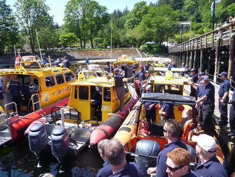 For the past 7 years I’ve been a SAR volunteer in Unit 1 (Horseshoe Bay, West Vancouver) of the Royal Canadian Marine Search and Rescue (RCMSAR). My unit had 87 calls in 2015, making it the busiest volunteer marine SAR station in Canada. It’s a situation that motivates a tech enthusiast and advanced crew member like myself to think about better tools and procedures…
On the West Coast of Canada RCMSAR’s 30 plus stations handle approximately one third of all rescue calls from the US / Canadian border to Alaska. The other two thirds are covered by the very hard working folks of the Canadian Coast Guard. Funding for both organizations is a continual challenge. The Federal Government sets the Coast Guard’s budget. The ability of individual RCMSAR units to fundraise determines their budgets.
It’s clear we must find a way to improve within the fiscal constraints we have. One of the ways to do this is to utilize technology in smart and productive ways.
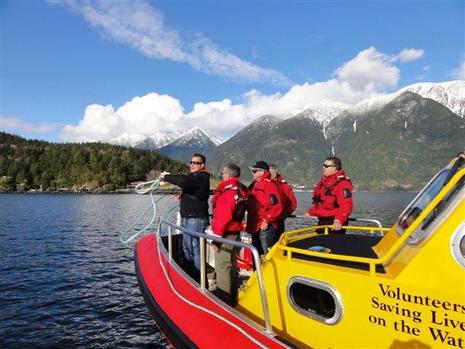
A great example of this is RCMSAR’s callout system, which was created by a member in my unit a number of years ago, and which simultaneously puts all unit members on a conference call when a tasking comes in. We can now verbally verify a fast response time and also that we have the crew resources we need. The system used to be pager based, which was far less efficient and ultimately meant a slower time getting the boat off the dock. Our callout system has been a huge success and has now been implemented in other first responder and SAR teams.
About three years ago I volunteered to write an iPhone Safe Boating App for RCMSAR to help with the organization’s public education mandate. I used a software development product called Livecode from a brilliant Scottish development team. The software is powerful yet simple enough for a rookie programmer like me to learn. It took four months part-time to create the App and get it approved by Apple. This was me starting with no programming experience at all! Since then it has morphed into three separate free versions:
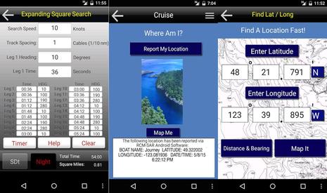
SAR Tools (Android) – Used by search and rescue crews worldwide to conduct sector and expanding square searches. Note that Raymarine is introducing similar search pattern features in Lighthouse II R16.
Safe Boating (Android) – Primarily for the boating public plying the waters off the West Coast of Canada.
Safe Boating (iPhone) – Same as Android version. SAR Tools is also included in the iPhone version.
Even if you aren’t boating in West Coast Canadian waters, there some useful tools in the Safe Boating App. You can snap a picture of your location to email to a friend along with your exact co-ordinates. I also recently introduced a “find lat /long feature” for when you hear coordinates on the radio and want a quick way to find the distance and location on a map. It uses complex calculations to get a distance (as the crow flies) and bearing to the waypoint. I tried to make the data entry technique faster than you can achieve on a multifunction display.
If you follow me so far I’m getting to the even more exciting part…
I was out training with my Monday night crew and we ran a scenario very common to the SAR community. Essentially a latitude and longitude is received on the radio from either a vessel in distress or more commonly from rescue command. The coordinates are then verified and the lat / long input to the multifunction display. In our case we have a network of older Raymarine E-series (not Lighthouse software) acting mostly as chart plotters and radar monitors.
Response time is vital and getting the lat / long entered accurately and reporting back an estimated time of arrival takes critical time that can slow the response. Most of the time an approximate location is given so the boat can head in the right general direction during the data entry, but this is not always the case. The exact bearing isn’t known until we have a waypoint to target. In rough seas (common) when you are screaming along at 40 knots over big waves, it is challenging to get the waypoint plotted. There are also other challenges such as hearing properly over engine noise, the possibility of human error, and cold numb hands in our open boats.
My grand vision is for Signal K to help solve this problem and others that I hope to discuss in future entries. Here’s a possible method…
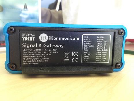
It would be fairly easy to create a secure tasking website so that rescue command can type the lat / long into a web-browser at their base and have those co-ordinates appear as a waypoint on the multifunction display of a rescue boat. Like a taxi getting an electronic dispatch, we can have a relatively inexpensive solution using Signal K. The cost is perhaps $400 per vessel if you include the cost of the Signal K gateway like the coming-soon iKommunicate and a wireless router with a 3G /4G internet connection. There would be an ongoing $10-$20 monthly data fee for the wireless carrier but overall this could be a very affordable solution that will save lives when seconds count.
Most (but not all) of RCMSAR’s stations are in range of cellular coverage. In situations where there was sporadic or no coverage, the fallback would be the verbal method we use today. A longer term project is to automate the logging of vessel data back to headquarters for engine monitoring and more accurate log keeping.
For 2016 my resolution is to try to make this actually happen for search and rescue. I can think of other applications for this technology as well. Fishermen could push hot-spots to friends, or bareboat charter companies could use it to help customers find a specific mooring. I’d love to hear your comments or suggestions.
– Safe Boating –
PS This video runs nearly 9 minutes but accurately portrays RCMSAR
Dear readers, please welcome Adam Hyde to Panbo. He can also be found at Signal Kool and I’m pleased to add that you’ll be seeing more of him here. ~ Ben


As a member of the USCG Auxiliary I find what you are doing a great idea.
With your permission I’d like to forward this article up the ladder and see if our Division & Flotilla would be able to use such assistance.
Thanks.
I really appreciate Adam’s search for a fast, efficient way to push critical Lat/Long positions to SAR vessels. But this also seems like a good place to suggest that SAR organizations use more than Lat/Long, at least when trying to get the public involved.
Of course I’m really talking about the U.S. Coast Guard, but maybe it happens in Canada or other places as well.
Here’s a situation I remember well. I was underway near Rockport when the Rockland USCG station came up on VHF 16 about a reported man overboard at a certain Lat/Long. Just about everyone hearing that broadcast had hundreds of local geographic references in their heads, but the repeated broadcast never added anything like “1 mile East of Owl’s Head Light” or similar.
I should probably be better than most at finding a Lat/Long position on a chart plotter or inputting one as a waypoint, but actually I rarely do either and I’m not quick at it. Meanwhile, one of the more common, and terrible, accidents in Maine waters is when a solo lobsterman gets dragged overboard as he or she is setting a trap. I think it’s often possible for a nearby boat to help, but the water is cold and the lobsterman’s own boat is usually moving away.
I agree that it is best practice for the public or Coast Guard Radio (CGR) to use both lat / longs and a general descriptive location. In the context of direct CGR to SAR vessel communication, this is usually done. It should also be done by anyone using a VHF radio where possible.
The reality is that it is easier to hear and immediately process a descriptive location (but it assumes you are intimately familiar with local place names which may or may not be charted). What I’m hoping for is just to make the lat / long transmission more automated for SAR.
Adam, Great Writing, Thanks!
Perfect example of new ideas enabled by an open marine interface standard.
There must be a mechanism to transmit and receive this information using the existing DSC and/or AIS equipment already on board, somehow??? Surely??
Good question, Derek, and I’ll take a crack as Adam is likely still asleep 😉
Yes, DSC and AIS are both able to push Lat/Long positions to a other vessels, but, no, neither includes a mechanism that SAR authorities could use to distribute the position of a vessel in distress or another marine accident to their floating assets and/or the general public, to my knowledge.
I think that the closest thing in the AIS system is the ability of AIS authorities to broadcast virtual Aids to Navigations, even temporary ones if, say, a ship sinks in a channel.
https://panbo.com/archives/2015/01/real_synthetic_virtual_ais_atons_can_you_see_them_.html
So I think the technology is in place to do something like Adam envisions, but just the addition of a virtual SAR icon could take many years to work through the standards and regulatory process (not to mention the politics of who does what to fire one off). Then again, it’s that same methodical process that has made AIS a reliable global safety and tracking tool.
I think the story is similar for DSC. Theoretically at least, your DSC radio should be able to push its position to any one DSC radio in range, some or all of them. (“Theoretically” because I’m not confident that every set has it, or that a normal human can figure out how to enable, or if it will always work across brands. Sorry!)
But this DSC feature very purposefully can only send your position, not a waypoint-like position that some idiot might misuse for some sort of false distress call. And again change could take many years.
I trust that Adam or other readers will catch any mistakes I just made. Please.
I’ll preface this by saying I don’t profess to be an expert at the intricacies of DSC and AIS technologies. In the SAR context the communication needs to be more private and direct to a specific vessel. If standard AIS messages were used they wouldn’t be private.
A DSC message can be directed to a specific MMSI number with location showing on an MFD, but it is generally used ship to ship not shore to ship. Also it is one location at a time and it was really not intended to be used this way. Sending waypoints or even a search route is the best way IMHO, and it needs to be cued to keep retrying in case the rescue boat is off line. A web standards based and easy to work with protocol like Signal K is really ideal for this. Though “proof will be in the pudding” as they say. I hope to try it and see how it works out. At the end of the day it is more about accomplishing the goal than exactly how it is technically done.