Lenovo Windows tablet, new MFD accessory or primary plotter?
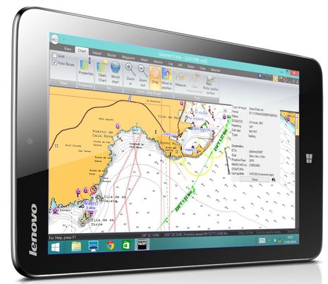 I first heard of the Lenovo Miix 2 when Digital Yacht dubbed it a “best buy for boaters”; besides a low price of about $220, the 8-inch tablet is purportedly bright, fast, and able to run regular Windows navigation programs like DY’s own SmarterTrack. While an internal GPS enables standalone navigation, the DY team mainly envisions the tablet as a second station using NMEA 0183 or 2000 boat data (like the AIS seen above), provided over WiFi by one of its many black box hardware options. But then a look at the Miix 2 on Amazon revealed a sailing reviewer who’s very enthusiastic about this tablet as his primary nav device, running free OpenCPN software…
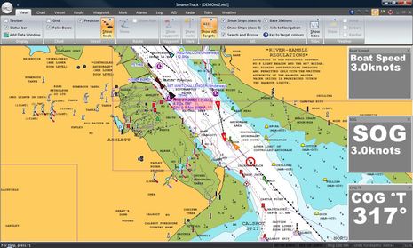
Before discussing the Lenovo tablet as a DIY chart plotter, here’s a SmarterTrack screen shot showing the tablet’s 1,280 x 800 pixel resolution (minus the bottom menu bar seen in the top photo). A significant feature of this setup as a second station is that a user can copy the Navionics chart card they’re using in their MFD to the tablet, including the latest Navionics+ with “Freshest Data” and SonarChart updates. SmarterTrack also seems quite adept at AIS plotting, able to graphically forecast Closest Point of Approach (CPA) situations as illustrated above. (It’s pure coincidence that my Raymariner experience last week included those same River Hamble waters.)
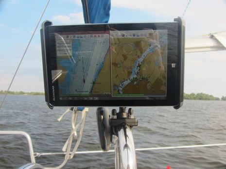
This image shows the Lenovo Miix2 working at the helm of a Catalina 250 on the Delaware River, and apparently, owner Rick S. is not only happy with the display, but did enough research to claim its daylight viewability is better than all the Windows 8 competitors out there right now. Besides that Amazon review, Rick has explained his nav system in detail on this Sailnet thread titled “Chart plotter or iPad.” It’s a good read if you’re interested in how this choice may play out, as I think both sides are well represented.
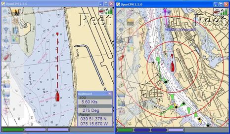 Rick is also an evangelist for OpenCPN, as you’ll find on this Cruisersforum OCPN thread — where he posts as “RhythmDoctor” — and in this tablet discussion. I’m not familiar with OpenCPN — Rick’s screen shot above was taken on the netbook that preceded the Windows tablet — but it obviously has a lot of fans, and Bill Bishop recently covered a new team effort in open source boat data called Signal K that might benefit efforts like OpenCPN significantly. Plus, Furuno really did come out with the 1st Watch DRS4W WiFi-only Radar (though Furuno USA doesn’t seem interested, and I don’t understand its value myself). I remain interested in all these developments, but I’m unable to envision tablets taking over navigation on a boat like mine any time soon. So I appreciate how Rick S is often careful to state that he sails in protected waters (though with lots of AIS traffic). I also notice that the Lenovo Miix2 is listed as “sold out” by the manufacturer and newer models are not specific about screen brightness.
But what happens when powerful, weatherproof, high-bright tablets come along at reasonable prices? In fact, last week I participated in a lively discussion on that topic in a very unlikely spot. Or perhaps it was the perfect spot, as the HMS Warrior — where Raymarine hosted a gala dinner on the gun deck — was apparently a marvel of warship technology in 1860 but soon became obsolete. Personally, I’m glad to have missed the opportunity to beta test the 110 pound breech loading guns, though muzzel loading 68 pound shells don’t seem appealing either. It was a heck of a spot to discuss the future of tablets and marine electronics, but several of the product guys and even the company’s general manager were up for it.





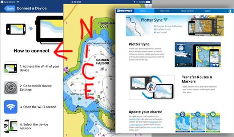
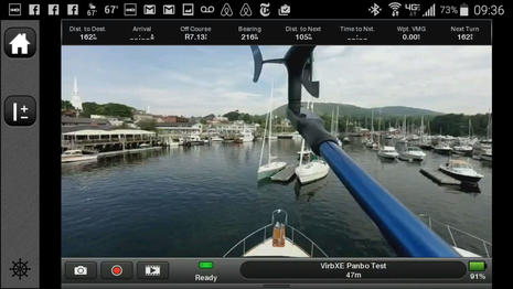


Last Summer my MFD died for about 2 months and I was forced to use my Galaxy Note 10.1 Android tablet at the helm. I tried 5 or 6 different apps (probably spent about $100 trying all of them) and finally settled on Jeppesen Plan2Nav. It was the only Android app I could find where I could create a route and then “activate” it so I could get things like final ETA.
Here’s my experience. It was usable, but that’s about the extent of it. No instruments unless I used a separate program (I have a NMEA0183 to Wifi bridge on board). Routing was basic at best – and I’m using the term “basic” loosely. No radar. The interfaces were difficult to manage. Precision in route planning was nonexistent. Most functions required multiple touches. And this was using the best of the applications I could find (with routes being the deciding factor). It WAS nice having ActiveCaptain integration though. Navionics is nice, but no routing.
Someone really needs to port a REAL nav app to Android – good charts; real route planning with things like course, ETA, multiple routes; tides/currents, instruments via WiFi (NMEA0183 or NMEA2000); Real usability for the interface. I keep hoping that Rosepoint will step up, but I doubt it.
This leads into your article. I think the only viable platforms for tablets on a boat are Windows or Mac. On the iPad side you have iNavx. I don’t know much about it, but I understand it’s pretty nice. On the Windows side – RosePoint is putting a number of enhancements into Coastal Explorer to make it tablet friendly. I think Coastal Explorer will be the real winner. Pair it up with a WiFi instrument bridge, a sunlight readable, water resistant or water proof tablet and you’ll have a winner as a secondary to a regular MFD (IMHO until radar gets into tablets, they can only be secondary).
I’m counting the months until Garmin and Raymarine release a tablet with a pop-off mount for the helm or other areas on the boat… probably paired with some sort of black box to manage the more intense computations.
Really looking forward to hearing more about your visit with Raymarine!
Thanks, Chris, well said. But the $5 Navionics navigation add on is quite powerful and I think we’re going to see their auto routing add-on get significantly better in the future (note that they now upload user routes and tracks to their servers unless the user opts out, so think about the crowd sourcing possible). I also think that the Nobeltec/Maxsea TimeZero app has excellent routing as well as gorgeous chart and sat photo imaging. And I agree with you that Jeppessen Plan2Nav is an able app, and possibly under appreciated in a very crowded field. Yike, Transas iSailor got a nice interface update recently and SeaIQ keeps over more bang for the buck. Finally, I think iNavX supports more chart types and way more boat data connections than any other.
But for my kind of boating — especially given the strange get-to-try-everything situation I stumbled into — no app compares to the major MFD systems for underway navigation, and none compares to PC software, particularly Coastal Explorer, for planning. I’m with you, excited to see how CE may come to tablets, but not holding my breath 😉
I read this article with great interest. It seems to me a “powerful, weatherproof, high-bright tablets” already exists in the form of Panasonic Toughpads. These are offered in 7″/10″ android or Win 8. There is even a 15″ 4K version which is also labeled a toughpad, but admittedly, less rugged. They are daylight bright/visible, rugged, weather proof, vibration proof, etc. The latest iterations are state of the art spec. wise. These are pricey and geared toward business types. It seems to me Panasonic could have some success marketing these to nautical types. They are prefect for the marine environment IMHO.
Thanks, Richard, but oddly enough the Panasonic Toughbook/pad line used to be more popular on boats than it is now. Here’s me testing one in 2003, for instance:
http://www.powerandmotoryacht.com/entertainment/cd-summer-school-page-5
That was the era when PC chartplotting was well ahead of what MFDs could do, and using radar separately was normal. Predicting the tech future is hard!
So the future premise I touched on was something like a Toughpad but brighter, faster, lighter, and at least 1/10th the price, a commodity in mass consumer electronics. But it might not happen 😉
I hear you, but 1/10 the price? Your asking for a lot for a little. : )
Exactly, Anon. Just trying to foresee truly disruptive technology. Remember that the iPad only arrived in this world in April, 2010. But the bigger point I was trying to make is that the screens aren’t that important to marine electronics, even if they seem like the very center of things right now.
I’d love the Navionics Nav Module, but it’s not available on Android. Neither is TimeZero, and iSailor isn’t available either. Marine Navigator only uses raster charts, doesn’t have great zoom capabilities and takes hours to import charts. The Android version of Navionics has almost no route ability. I bought the NutiChart app and charts and then the company discontinued the product.
Having already spent $100+ on various Android apps and charts, I haven’t dropped the money to test out a few others – MX Mariner, Memory-Map, AFTrack (looks interesting – might include instruments). I’d love to take a peek but I’m not going to spend more right now.
All I’m saying is that Android is lagging FAR behind iThings and Windows with regards to marine navigation.. and considering there are more Android devices out there than iThing devices at this point it’s a shame.
Chris
No rudeness intended but it sounds like you should spent your money on a Lenovo and get OpenCPN or install your already paid for windows nav software!
Just and FYI for anyone interested….I managed to snag a refurbished Lenovo Miix 2 for $125.99 on their outlet site at http://www.outlet.lenovo.com. They go in and out of stock so you might have to check often. I’m looking forward to seeing how OpenCPN works on this.
Here’s a pic of Lenovo and E90W side by side on a sunny day in Turkey this week https://twitter.com/DigitalYacht/status/477354302525427712/photo/1 Tablet is running DY SmarterTrack using same Navionic’s chart as the E90W so the mapping is identical. In reality, the photo doesn’t do the two justice and both screens are very useable.
Sorry, Chris, I forgot that you’re using an Android tablet. A problem I almost hesitate to mention is that while there may be more Android devices than iThings in the world, the ratio tilts strongly the other way in the much smaller boating world. Or so I’ve heard from marine manufacturers who offer both (Navionics, for instance, says “the difference is overwhelmingly in favor of iOS”).
Thus it may make sense that there’s a lot less competition among Android boating apps, but maybe that’s an opportunity for some developers. (BTW, I think Memory Map has a strong Android app with good routing and useful integration with a PC charting program; the charts and maps are raster but very fast and good looking.)
PS Some good news on Navionics Android apps: despite the lower sales, they do intend to fully align them with the iOS versions — including the free Govt charts and eventually the nav modules — starting soon. Moreover, they recently added a development team in Estonia that’s particularly strong in Android:
http://www.navionics.com/en/news/navionics-expands-development-team-estonia
(In fact I just had to turn down an invitation to a joint presentation by Navionics and the government of Estonia which will include a visit with President Toomas Hendrik Ilves, who is purportedly “the only head of state in the world who’s been a computer programmer since childhood.” What a world it is!)
I’ve been using used Fujitsu Windows tablets off of Ebay for years as a backup or secondary display. I would say that the average price has been $125 and when I have one at the helm I keep it in a protective case. I have yet for one to fail from the elements. In the past I’ve had a 0183 to wifi serial port server to handle the boat’s data. The Windows machine runs Coastal Explorer but I also have an ipad running inavx. IMO Coastal Explorer beats inavx by a mile in usability.
Now I have a new (to me) boat with modern NMEA 2000 instruments and this weekend I’m installing wifi interfaces to replicate the same functionality. I like being able to check on the boat’s operation from any device, including from off of the boat and my iphone. For ease, I’ll still be plotting my routes on Coastal Explorer and transferring them over to the primary instruments.
I will definitely be looking at the Lenovo machine for upgrading my XP Fujitsus.
I have been using several different Windows running devices with Coastal Explorer. I have two Lenovo M92P Tiny PCs mounted under my helm. One runs Maretron N2KView and the other runs Coastal Explorer. I like splitting the screen with the Coastal Explorer and view video cameras.
Due to my work, I have several laptops and tablets. I like the Lenovo Helix tablet and the Dell Venue 11 Pro. I prefer the Windows tablets over several iPads I have because they have more functionality with USB and display ports. Unfortunately, the market is such that most applications are first coming to the iOS market, then Android before they reach the Windows markets.
I have been waiting for the past two years to find a tablet with a 12-16″ display and higher brightness. No joy so far. I have been waiting for a broadband or HD radar that would interface with Coastal Explorer – also no joy.
So, I recently installed a Simrad NSO evo2 with twin MO16-T touch screens. Part of the reasons I opted for the Simrad was 4G radar, the HDMI input to the monitors and the cartography options. I now have the two PCs connected as sources to the monitors as input 2 over DVI interfaces. I still can remote into my network from any tablet, laptop or phone to monitor my boat, view the N2Kview (via TeamViewer) and view the cameras.
I expect in the next few years, the tablets will become very standard practice on boats. The low power draw, mobility and price point will be hard to resist.
A note of warning from Fugawi, regarding their testing of Fugawi Marine 5 on the Lenovo Miix 2:
“The Fugawi Marine 5 and Navionics do not work well on Atom based tablet. It was not able to load Navionics charts at all. Atom’s type of hardware is very slow and weak. This one Lenovo Miix 2 built on newest Atom hardware, which still couple of generations behind hardware used for Microsoft Surface Pro. Microsoft Surface Pro the only one Windows 8.1 tablet, which shows acceptable reliability and performance.”
this may be of interest to the group
http://www.engadget.com/2014/07/18/lenovo-halts-us-sales-of-small-windows-tablets/
I have a different suggestion …
The Surface 3. This is a tablet but it is also a nearly perfect laptop. The stylus is a huge plus as it allows you to take notes or right on charts.
While I do not know if the screen is all that good in sunlight, I plan to use mine at my lower con as a planning tool and add on to my Raymarine E10.
Rick is also an evangelist for OpenCPN, yeas and he forgot to mention that he is also evangelist of pirated CM-93 last time updated 5 years ago that it is installed on that Lenovo with OCPN on it.
antun comb…
Sorry, but all I see on those screenshot from Rick’s machine, are the official and freely available NOAA raster and vector charts.
Pavel
Have you heard of the Panasonic Toughpad?
Of course you have! Silly question LOL
I personally use these on our fleet of charter boats and always recommend them to new boat owners and any new fleet we take charge of.
That being said, most boat owners tend to use their own iPads or smart phones and simply clip them into the harness on the boat and away they go.