Lowrance Elite-4 HDI, a whole lot of tech for a little dough
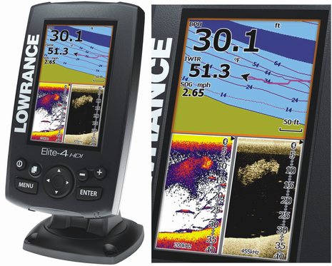
 While I don’t normally follow the small-size displays closely, the new Lowrance Elite-4 HDI models announced yesterday seems to sport a remarkable ratio of dedicated marine electronics to cost. Their bright 4.3-inch LED-backlit screens, for instance, are substantially bigger than the Elite-4 models they replace, which were praised for their value. The plain Elite-4 HDI model, with a suggested $299 retail price, not only offers both regular fishfinding and high-frequency narrow beam downscanning — each with a shallow/deep frequency choice built into the included transom transducer — but also includes GPS, a bundle of lake and coastal cartography and support for all sorts of chart card types…
The new Elite-4 models can even display and alarm AIS targets — though via NMEA 0183 only, as 2000 support is one of the few features they don’t share with larger Elite HDI’s — and I won’t be surprised to see one on a bigger boat being used for secondary or backup AIS and/or chart plotting. They can even be flush mounted. The right model for such use, though, may be the Elite-4 m HD Gold, which includes an SD card of Navionics Gold detailed charts for the U.S., Canada, and Bahamas while losing the fishfinding and $30 of suggested retail. There’s also a $199 Elite-4x HDI that’s fishfinder only and an Elite-4 HDI Gold that includes everything mentioned for $369.
Don’t I remember proprietary memory cards containing small regions of relatively crude digital charts that cost as much as all this hard and software? I know that the beloved trend of consumer electronics is more for less, but it often seems less evident in the much smaller world of marine electronics. I suppose it’s the relatively high numbers of small fishing boats that largely make this high level of boat gear value possible, but isn’t it also a reminder of how far and fast we’ve come?
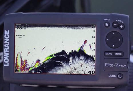
 Plus, the Elite Hybrid Dual Imaging models offer a Downscan Overlay feature that seems valuable. I don’t have an image of it working on the new Elite-4 display, but you can see it in action in this Elite-7 HDI video. The idea is that laying the more detailed structure-oriented grayscale downscan imagery over the blobbier, but more sensitive and color-coded Broadband Sonar, can reveal fish even when they’re otherwise nearly hidden in the structure. I have not yet seen this feature live (that may happen this January in tropical waters ;-), but I suspect that it’s another reason why fishermen who already have a finder and even curious cruisers may be interested in the new generation of sonar. Note that Lowrance has Humminbird competition in this same size/price range, and if you’re looking for a somewhat bigger plotter with advanced sonar, you should also check out Garmin’s latest and Raymarine’s latest. (Heck, Furuno even has value-oriented plotter/fishfinders now.)
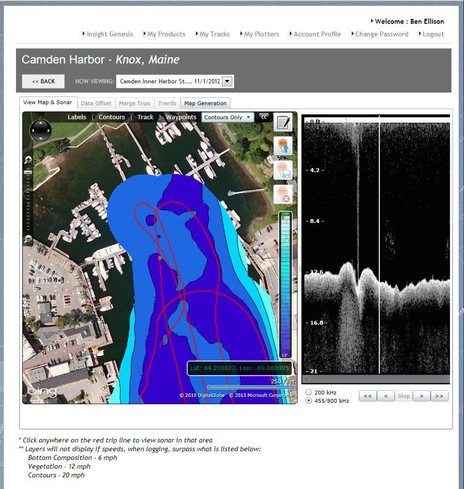
Finally, check out the free Insight Genesis custom online chart of Camden Harbor that I was able to create with just the downscan data I can record with the StructureScan unit on Gizmo. I can use it to watch the downscan video anywhere along my recorded track, so I’ve seen enough versions of the unusual structure shown below to be sure it’s the outlet of my town’s wastewater treatment plant! If I had an Elite-4 or many other Lowrance dual imaging setups, I could also view the simultaneously captured sonar and if I purchased an Insight Genesis subscription, I could adjust the map for tide, view bottom types and even download a chart I could take back to the MFD (good how-to article here). The bottom line, so to speak, is that you can create maps like this with just a small boat and less than $300 worth of electronics.


The Elite-4 HDI series has TrackBack as well as Sonar/DownScan logging. In other words, you can scroll back and mark interesting targets. The manual, which seems quite good, also claims maximum depths of 300 feet for the 455kHz downscan, 750 for the 83kHz sonar, and 2000 for the optional 50kHz transducer. Each of those frequencies has a higher sibling for better resolution in less depth. Quite the contrast with the “flasher” I sailed with many decades ago: http://goo.gl/xtqrl8
I really want to know how you made that track and managed to doge all of the boats in the harbor. 🙂
Sounds like you’ve been here, Andy 😉
All the standalone two-boat mooring floats look daunting but they are designed with lanes. If you compare those tracks with Google photo map, you’ll see I was just driving the lanes: http://goo.gl/RzfPV2
Fun, I just noticed that the photo map is fairly new because Gizmo — on float A5 with a rower just off the starboard bow — is showing the solar panels I installed in 8/2012. And the tender attached with Weaver Clips to the swim platform indicates that I was aboard. Nice to remember when it’s raining on top of two feet of snow!
Ben, I looked that the Lowrance pages that you referred to, but I don’t see where the 4.3 inch models have ANY networking capability – the installation manual claims that the -4 m models don’t even have NMEA0183. As far as NMEA2000, while they brag about it, nothing on the pages seem to indicate which models do or don’t have it, or what it is capable of in terms of display (all they says it is allows “sharing of waypoints”)
Hartley, are looking at the Elite-4m HD manuals?
http://www.lowrance.com/Root/Lowrance-Documents/GB/ELITE-4M_HD_OM_EN_988-15081-001_w.pdf
http://www.lowrance.com/Root/Lowrance-Documents/Elite-4-HDI_IG_988-10575-001_w.pdf
The new 4m definitely has NMEA 0183 like the new HDI models, but I just noticed something whack in those manuals. The installation instructions specify and illustrate only 0183 Output while the Operating manual AIS section shows how to change 0183 baud rates to receive output from an AIS transponder. One or the other is wrong, unless I’m missing something?
Hi Ben – exactly – something is out of whack for sure – the manual talks about setting the 0183 output rate (but not input rate), the available 0183 sentences and (in a different place) says it can display AIS – but the installation manual shows ONLY 0183 output and no input wires – something is confuzzled, for sure. The install manual also says “not applicable for 4x models” next to the 0183 wiring diagram.
Maybe they read Panbo and will jump right on it..:-)
Meanwhile, raining on top of 2 feet of snow does NOT sound like good boating weather – U need to relocate your winter HQ about 1500 miles (or more) south..:-)
I have been looking at the 4m gold as a fixed GPS on my Oday Mariner 19. With the updates I think it makes it even more the perfect small boat GPS/fishfinder. One of the features I lime is the removable mounting quick and easy for this type of GPS. I believe Tim lackey at Lackey sailing installed one on his new motor sailor project as a back up to the main Simrad system.
http://www.fisher30.lackeysailing.com/
There was a typo in the manual that got posted to lowrance.com
The Elite-4 HDI is capable of AIS via NMEA0183 transmit and receive.
We are working on correcting the posted manual.
Navico just announced that they’ve acquired Contour Innovations, the company responsible fro LakeTrax and Navico’s Insight Genesis system seen above:
http://www.contourinnovations.com/
I’ll be at a big Navico press event in the Florida Keys on Wed. and Thurs. so there may well be more news.