Summer adventures, helped by a Lowrance 113-LCX
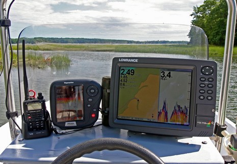
So far this season, I’ve had two excellent, and very different, voyages of discovery aboard Gizmo, and the test Lowrance 113–LCX HD has been very useful for both. As shown earlier this month I’ve got it rigged to a small NMEA 2000 network, which feeds the LCX the output of at least two GPS receivers, a Lowrance EP60R fuel sensor, and a Maretron Weather Station, with many add-ons possible. Check out a bigger above image , showing Gizmo up a tidal tickle in Maquoit Bay, about as far into Casco Bay as a boat can go…if the tide is high! The LCX, using just the Skimmer transducer it comes with, had no trouble with these shallow readings, even at 20 knots (once I got confident that the immense mud flats are flat indeed). Notice too the 76 degree water temp, which I’ve never seen in Maine salt water and which partially accounts for the happy bird life in this new preserve.
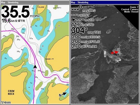
The Eastport area was an entirely different story, like 55 degree water even way into Cobscook Bay. Shallow water isn’t an issue around here, but tidal currents surely are; “Cobscook” is derived from an Indian word for waterfalls, as in the reversing falls generated by an 18’ tide trying to fill or drain this huge, mostly wild area via relatively narrow passages. You can even see them on Google’s low resolution photo maps. Could Gizmo passage the reversing falls? Well, even within an hour of slack low, it was a pretty exciting trip. In the screen shot below, bigger here, you can see that our speed through the water is almost 4 knot slower than our SOG, and what you can’t see are the whirlpools and upwellings! Note that the Navionics Gold photo map in the right window—as always a moment in time, not real time—shows the tide flooding, while we were going against it, and there was no white water, at least for an hour or two.
By the way, the LCX only seems to show photo maps in 3D mode, but that’s one of its few shortcomings so far in my experience. {Correction: it does Platinum photo map overlays pretty well, with a choice of four transperancy levels; I just missed the menu item.} Again the Skimmer held bottom solidly, despite the tremendous water turbulence. And the screen was always quite readable despite lots of sun on both trips. Note too that the windows below are labeled “Simulating.” That’s because I used the LCX’s sonar recording feature to save sonar, track, speed, COG, SOG, and heading for the whole trip. Now I have a 180 Meg file on its hard drive that I can play back, changing zoom levels, windows display, etc. as I please, even taking screen shots. That’s why the the fuel flow is shown as zero (the values aren’t saved and I captured the screen with Gizmo on its trailer). It’s a great feature, but I’m not sure if my dear wife would care to relive this particular Gizmo ride.





What about radar and Lowrance. Can they offer same quality as Raymarine, Garmin and Furuno ?
All: please note my correction; the LCX does do Navionics photo map overlay.
“radar”: sorry, I don’t know much about Lowrance’s radar; I’ve only been on the water with it once, briefly, and didn’t get much chance to study it. I do notice that Lowrance is claiming HD performance for its 18- and 24-inch domes, but there really isn’t an HD standard.
have used Lowrance radar now for over a year.
Excellent display. Has radar overlay. Have
used many radars and in the 4kw dome class,
this one is as good as any. No problems at all.
Many screen color combinations and zoom ranges.
Easy to install, setup and use.