
Lowrance NauticPath, the rock problem
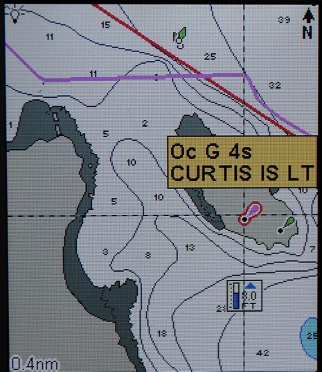
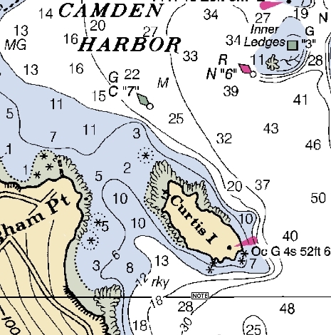
I’ve done more testing of the Lowrance ExplorerC handheld, and still like it a lot, but there are some real issues with the NauticPath charts. The main one is the absence of “obstructions that sometimes cover/uncover”, i.e. the damn rocks marked with asterisks on the paper chart below! Compare the two charts—soundings, bathy lines, high and low tide shore lines are all exactly the same…but rocks that may be just below the surface at any tide have vanished from the NauticPath (though I’m quite sure they were in the original Transas chart database). Those asterisk symbols are critical information, and they seem to be missing from NauticPath wherever I look around the country. The same is true on the LCX-111C downstairs, with a different copy of NauticPath on its hard drive, though on that machine the aids to navigation do not show double as they do on the Explorer (above). At any rate, I dare say the folks at Lowrance may be a little distracted right now, but I am going ask if they intend to put the rocks back in NauticPath.


Here is the NOAA ENC version..
Click Here
Interesting! The ENC as presented does NOT show the rocks. I see the same thing in Coastal Explorer, until I turn on “Full Object Display”, and then the rocks show. I’m surprised that critical detail like that can be turned off.
Note that the best ENC (at the moment) for this area is based on the 1:40,000 scale coastal chart, not the 1:20 harbor chart shown in my entry. That’s why, in some ways, the NauticPath is more detailed than the ENC.
The S-57 ENC specification makes no assumptions to rendering the data other than to adhere to the minimum scale of each feature. That is only to display the feature when the scale is equal or larger to the features minimum scale.
The presentation is up to the specific application. MacENC chooses to use the text “rock” where other applications might use the traditional * with a dashed circle.
One of the signifcant benefits of the S-57 ENC vector data is that it can be queried. So no longer is displaying everything on the 2D display required as is with a traditional raster (scanned paper) chart.
This gives a much cleaner de-cluttered screen. Only when the user wants to “see” more information about a feature they can click on it to learn more.
Furthermore with MacENC the user can quickly toggle the raster chart such that is overlays the vector chart. This gives the best of both worlds allowing the user to querey the raster chart using the vector data.
Example raster chart overlayed on vector chart data..
Click Here