Sirius vx XM, doing thunderstorms, (updated)

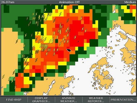
I do feel a little guilty. My buddy Jamie was out there in those islands with friends and family on a Maine Cat 41, and I knew it, but didn’t think to call his cell and advise him about just where those monster thunderstorms were tracking Tuesday evening. Yeah, they’d heard the warnings beeping all over the radio, but still didn’t know if a cell would actually hit them, or when, until one rolled over the horizon (which surely happened, as shown so vividly above). Sorry, Jamie!
It was too bad because I could really see what was going on, having fired up both the Sirius and XM live weather services I’m testing. My goal was to see how detailed and accurate the satellite information is, and more specifically if it could have helped me get around the worst of the weather in a reasonably fast boat. Conclusion: Yes, if the cells aren’t coming at you in a solid line, and the boat is fast enough. Of course there are numerous subtle differences between the services, and a few anomalies. In the latter department, observe the two photos below, Garmin XM on top (bigger here), Raymarine Sirius below (bigger here), taken at almost exactly the same time.
For some reason Sirius was not tracking any storm cells in New England that evening, i.e. was not generating the arrows that indicate speed and direction, and can be clicked on to reveal more information like chance of hail. XM’s tracking, which nicely indicates the dimensions and speed of the cell, was working fine, but its analysis of precipitation seemed to be markedly off. I was there, and the rain was tapering off just as indicated by Sirius, not about to pour buckets as suggested by XM. Yes, XM shows a 4 minute delay, but I don’t think Sirius was much fresher (it should be time stamped). Hell, that data has to go from the radar station out to a network, through the processing facility, up to the satellites, and back down to these machines. A four minute delay is damn good, especially given this level of detail for the whole U.S.A. And that’s the real story here; I would really like one or the other of these services at my helm. More tomorrow.


7/21 Update: Sirius and data provider WSI are trying to figure out why those storm cells weren’t being tracked (I see a similar problem today off Long Island), and I have a call into XM about why their Nexrad might be a little off. In the meantime, a couple more notes to go with these illustrations:
* I like how Raymarine overlays the weather on a simple outline map, instead of charts, but it would be good to add some landmarks for orientation, like maybe port names. I found myself turning all sorts of stuff off on the Garmin charts, stuff I’d like to see otherwise, so I could see the weather better. On the other hand, the streets and names on the Garmin were useful when overlaying cloud cover, as seen above. Sirius does offer cloud cover, but does have Canadian weather radar.
* Garmin’s new “Presets” weather interface is excellent. See the “Storms” lower left on the screen; push the Next Preset soft key and you get the “General” preset, then the “Sea State” preset. The names don’t really matter as you can go into the weather setup area and customize just what mix of data you want for each preset. Moreover—and Garmin has had this for a while—you can specify presentation of individual data types by zoom level. That’s a little harder to get a grip on, but also helps you mix all the data available in sensible ways. I encourage Raymarine to steal the preset concept, and maybe the zoom level too, ASAP!


Has anyone out there used either the Sirius or XM systems for fishing? How good are the SST data? Can you send me a few screen shot if possible?
Thanks,
Mark