
Garmin Colorado, next gen handheld?
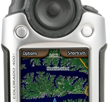
Last night Garmin announced a slew of new mobile products, and I must say: WOW! Check out the Colorado, a high-end handheld designed for driving, hiking, boating, and…um…multimedia, location-aware, gaming/educational experiences! The interface is neither old Garmin handheld nor new Garmin marine, instead featuring that big ‘Rock ‘N’ Roller’ thumb wheel/cursor thingy, and two soft keys. The wheel brings up a spinning menu system (seen right) that’s a bit like Furuno’s RotoKey.
The 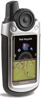 hardware specs sound spectacular: bright, 3”, 240 x 300 pixel screen in 65k colors; “high sensitivity” GPS (perhaps like G’s new N2K sensor, which can be mounted under some decks); 15 hours on 2 AA batteries; 2–axis compass; altimeter and temp sensor; waterproof to IPX7; and, dig this, ANT wireless for sharing routes, etc. (and who knows what to come). There’s also a USB port, an SD slot, and lots of flash memory. Aside from the amount of that memory, Colorado seems to be a single hardware/interface platform which comes in four models, starting with the $500 base model 300 and moving through three $600 models pre-loaded with 3D topos (the 400t), inland waterways (400i), or coastal BlueCharts (400c). But I bet some boaters will buy an “i” or a “t”, planning to insert their existing BlueChart G2 cards for marine use. It looks like Colorado may also work with older BlueChart CD-based charts, or any other Garmin cartography including photo maps. And it can play Wherigo files, that very new “experience” thing I mentioned, which might enable extraordinary “cruising guides”. There’s lots more Colorado info at this Garmin site, as well as at this special Garmin CES preview (which includes several other new products, like the nuvi 880, with might-trickle-down features). My first impression is that Colorado may mark a new generation of handheld plotter power…but then I stumbled on the DeLorme Earthmate PN-20, which can even display NOAA raster charts. Oh my.


Correct me if I am wrong, but it appears the Garmin Colorado does not appear to support NMEA data hence making it unusable with many marine navigation applications. Garmin’s own Mapsource does not do real-time navigation. Garmin’s USB cable does not support NMEA data, only their own proprietary data format for transfering routes, waypoints, tracks etc.
How did you determine that? I can’t find a manual to download.
It’s an easy bet. Garmin has had USB-only handhelds for over 3 years and there have been complaints about no NMEA for about that long. Garmin does have a PC program to provide NMEA data via a virtual serial port (“Spanner”). That solves the problem for some but not all.
It isn’t clear if the DeLorme PN-20 can accept the charts you download from NOAA or if you have to buy the NOAA charts from DeLorme.
I have a Garmin 76csx with USB output that supports NMEA.
When someone says “it appears that”, I think there needs to be some basis in fact. Otherwise, it’s more like “I speculate”, or “IMHO”.
Russ, the Garmin 76csx supports NMEA data only through it’s serial cable (power/data cable) and not through it’s USB cable. When looking at the Colorado accessories I did not see a Garmin PC interface cable or power data cable similar to what is available for the Garmin 76csx.
Regarding the DeLorme PN-20 & NOAA charts, I emailed DeLorme & received the following response from their Sales & Service dept.:
“Thank you for your email.”
“At this time our PN-20 will only accept information from our TOPO USA 7.0 software.
“The NOAA charts are the actual scanned charts that have been formatted properly to be downloaded onto the PN-20.”
Guess not.
The Colorado appears to support NEMA out with a with a MiniUSB to DB9 cable (010-10572-00). This still needs a serial to USB adapter to use the USB port of a laptop. There is also a MiniUSB to cigarette lighter adapter for external power. If you go from MiniUSB (Colorado) to the USB port of your laptop, the Colorado goes into external drive mode (like many cameras) and the real time Lat/Lon updates stop. The objective is to find a configuration that converts the serial data out to USB and also powers the Colorado from the laptop USB port.