Lowrance Broadband Sonar, a “disruptive technology”?

Lowrance’s Broadband Sonar was announced back in July, but—judging from the chatter on forums like BassBoat Central, BassPro Shops, and the Hull Truth—it’s just now getting to market. So there aren’t yet many consumer reports about its performance yet, but, man-o-man, the folks at Lowrance and mother company Navico are some excited about it. At METS CEO Jens-Thomas Pietralla called it “a fine piece of disruptive technology,” by which I think he meant that it has the combined performance and value to upset the whole world of fishfinding. His claim echoed (so to speak) an excited Lowrance rep I spoken with at the Fort Lauderdale Show.
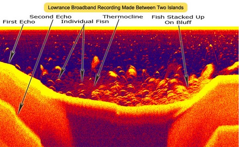
Dusty Walker told me he already done three round trips to the Bahamas with the unit and had never lost bottom, and that was “with a bitty 500 watt transducer.” Now of course you don’t really need to see bottom at 3,000 feet, but a sounder that does can probably also see a lot of fish detail in 500 feet. The Broadband Sonar—a $600 Ethernet blackbox unit detailed here—can supposedly pick out incredible detail in shallow or deep water, and a big, expensive transducer isn’t needed. Dusty claimed it gets the performance of 3,000 watts out of 500, and added “no one has ever seen this before. The detail is incredible; it can pull a snook out of a school of mullet!”
I further understand that Lowrance has “just gotten started” with this technology—forward looking sonar (I hope), or what?—and that Navico plans to migrate it through all its brands eventually. Now just how it works I’m not sure, but it seems to be all about DSP chips and software. I must say I’m not too crazy about the name because there is another sonar technology coming out of Airmar that really is broadband in the sense that a wide band of frequencies are put out simultaneously by a single transducer. Lowrance’s new unit can operate at three different frequencies but it’s not broadband in that way. But I quibble. If this thing does what they say, it may indeed be “disruptive” (in a good way). I’m sure the fishermen on the forumswill be reporting on it soon, and so will I after seeing it in action at the Miami Show next month.


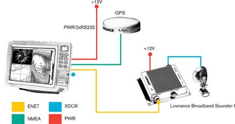
As I read the product information, it only connects to a Lowrance head unit. Imagine if your Sony VCR or DVD player only connected to a Sony TV. What good is “disruptive” technology if it isn’t compatible with other systems?
Marine electronics vendors are so stuck in the 70’s!
If they want to be really disruptive … how about taking this capability and apply it to improving our cartography ?
It looks like the scanned area is many meters wide. Imagine if this could be captured with the GPS position by thousands of fishing boats that make nearly daily trips, that the fisherman could get $10 a day for the data they capture, and a computer could normalize and compile the information make calculations against tide data, etc. … how little time it would take to update the outdated depth information on our chartplotters ?
B393capt: I’ve discussed that with a few people before. Why doesn’t Nobeltec / C-Map do something like that, or MaxSea? Both have the depth capture s/w. Rather than charging people to buy the s/w, they should be giving the s/w away for free to people who will send them the data. Beats waiting for the governments of the world to send out survey ships.
This is an example of why getting open standards for Ethernet-based instruments is at least as important as NMEA2000. There’s no a priori reason the images couldn’t be displayed on any computer-like thing that speaks Ethernet.
As for “broadband” – without knowing a lot about the waveforms used on the transmit side and the processing being done on the receive side, i’d be loth to make a pronouncement about what constitutes “true broadband” in this context.
Waiting for the government to update the depths in our cartography, much of which is over 60 years old, isn’t even an option.
The current NOAA fleet, reduced from 11 survey ships to 3, using 20 yr old technology (since 1998 they have been frozen in spending money on new equipment), with a revised mission to survey ocean only deeper than 18 feet and only in those 41 areas vital for commercial interests … which they are still underfunded to accomplish, is not an option for the recreational boater.
http://www.boatingmag.com/article.asp?section_id=9&article_id=215&print_page=y
There are probably some challanges in integrating data from 1000’s of fishing vessels and potentially other vessels that are frequently under way. However, I would imagine some smart statistical people could find a way to integrate measurements from a single well calibrated vessel traversing each harbor, to make use of the data from 1,000’s of other boats to create a very good result within a short time.
It would all be so much more doable, if future recreational products came out with a usb port to which the data could be captured in combination with a boats GPS data, date & time, unit model & serial number, date/time of last unit calibration or other indication that the installation has been altered. The data format wouldn’t even need to be agreed upon between vendors either, just capture the data, some bright scientists can take an actual production units and normalize the data between them.