
A screenshot feature, do it!
Whereas I got the week started on what’s largely a trade subject, let me add an unsolicited suggestion to everyone who makes plotters, multifunction displays, or any other marine electronics with a dedicated screen and some sort of accessible memory. If possible, please add a screenshot feature! My intent is obviously selfish; dumping .jpg or .bmp files to a CF or SD card is so much easier than photographing displays, and the results so much better for web and magazine readers.
My wishes aside, though, companies that develop this feature—I’m thinking of Raymarine and now Lowrance, seen above—will not only see their product screens shown better, but may get publicity they never expected. I’m remembering an article I saw somewhere which, while on the general subject of route building, was illustrated almost entirely with Raymarine E-Series screenshots. I knew why immediately. (And if there are other marine machines that can make screenshots, please tell us.)
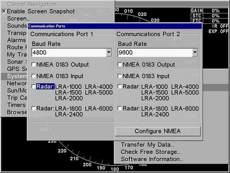
On E– and C-Series, and probably G’s (?), you just hold down the Data button until you hear a second beep, and there’ll be a .bmp file on whatever CF card is inserted (as long as it’s not already full). My understanding is that the feature was initially built for the benefit of Raymarine’s own marketing department, plus writers, but eventually it was realized that many regular users like to save screens, plus it can be useful for trouble shooting. Lowrance apparently just added that “Snapshot” feature to its operating system, and when enabled you save a screen just by hitting the power button (but you have to disable the feature to get dimming back). Many Lowrance units have long had the ability to save streaming sonar imagery along with track data for later viewing at home, with free software, or playback on the machine split screen with a chart replay if desired. It’s cool, but it’s the snapshot feature that will soon help me show you the Lowrance Broadband Sonar in action. It is disruptive!
PS Today is supposedly the day the FCC may permit Class B AIS. Cross your fingers, and please be in touch if you find out what happens before you see it here. Update: What I’ve heard is that the FCC Chairman dropped the AIS issue off today’s agenda, for reasons unknown. There was also a chance that the Commissioners would just sign off on AIS B without discussion, but that has happened yet either. The FCC AIS B saga continues…


Excellent suggestion (Furuno?). It would be so nice to be able to send a screen shot to a support person to unambiguously communicate what is happening on the screen, or easily capture a set of configuration choices to show how the equipment is set up.
The LOWRANCE moving image recording feature is a bit unusual in that it allows you to make adjustments to certain parameters post-recording. You can adjust the signal processing after you’ve made the recording. That implies you are not really recording the screen but the data that was processed for the screen.
On those LOWRANCE static screen shots, what is the file format? I hope it is something generic, like .BMP. And, can you grab the SONAR echoes or just the control screens?
The nice feature of the RAYMARINE devices is the screen capture can also record meta-data which will give the latitude and longitude, and other information. Also, the files are generic, so you can view them with any computer. You don’t need to run a Windows binary executable to get access to them.
Jim, The Lowrance screenshots are .jpg files, which I prefer over .bmp just for size efficiency. Also I think I recall that the Lowrance units give you the opportunity to custom name the file, if you want; Raymarine just auto numbers them.
When you say “meta-data” you just mean anything that’s on the screen, right? Or is there other data somehow attached to the .bmp image?
In the screen dumps I have taken on my E120, the files that are created are BMPs, and there is very limited meta-data. The data that’s saved with the file is limited to image data (i.e. width, height, horizontal and vertical resolution, bit depth (number of colors), and frame count). There is no position information (or any other info that could be available to the display such as depth, water temp, course, speed, etc).
Joe
The Northstar M84 (and M121) also has a screen snapshot feature which I find very useful. When I was first setting up my new M84 I had a couple issues with tuning the radar and being able to send a snapshot of the screen to the tech worked very well, he could see exactly what I was seeing.
I’ve also taken snapshots of my chartplotter screen with my track through the tricky mangroves here in Panama, then I can pass along the photo to a buddy boat that wants to make the same trip.
Lots of other useful purposes too if you want to be creative enough.
Damon
Re the Meta-data (the data about the data) available on Raymarine sounders, this is from the manual for the A65:
—
Save Image to User Card….When you make this selection, the following is saved onto the card:
• bitmap screen shot of your A65 display
• text file listing the essential data at the time of the screen dump, such as lat & long, speed, etc.
• screen shot and essential data saved in an HTML file
—
I don’t know if every Raymarine sounder has this capability, but it would seem the A65 does.
Here are some screen shots from a Raymarine A60 which I was able to transfer via Compact Flash memory card to my MacOS computer. There is also a sample of the meta-data file.
Also, the A60 (and A65) generate a small web page containing an enlarged version of the screen image, the meta-data, and a link to GOOGLE EARTH at the latitude and longitude of the recording.
See: http://continuouswave.com/whaler/reference/A60.html