Chart ruminations, from an undisclosed location

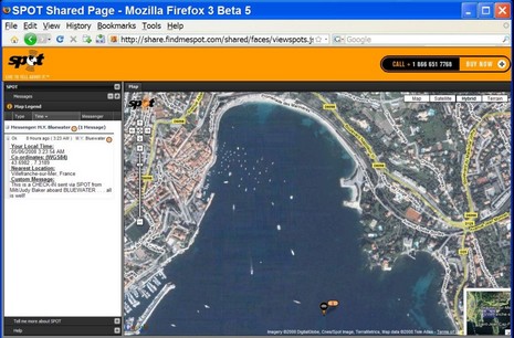
Panbo commenters don’t seem very interested in Spot sharing, but I think it’s a cool deal for long range cruisers like Milt and Judy Baker, not to mention working mariners like Capt. Richard Rodriguez. Note how the Baker’s custom message is displayed next to their anchorage on the French Riviera, above and bigger here . And today I notice that Mad Mariner apparently has arranged with West Marine for an extra special Spot deal ($132), and that West customer product reviews are all five star. Even the SSCA offshore guys are taking a cautious look at it
Spot sharing also reminds me of Google Map/Earth’s ubiquity, and ever growing power. (Team Doyle, incidently, has a complete review of related EarthNC here.) On Thursday I used the latest GE 4.3.7 version to work out a five mile walking route around the Florida port town I was in. Like so much of Florida, this area was quite pedestrian unfriendly (what’s with that?), and the software let me maximize sidewalks and even visualize the spots where I’d be threatened by traffic. In fact, I “prewalked” the route in 3D high res detail, didn’t get lost, and knew a bit about some of the parks and other POIs I visited. Good stuff. I’m being a little evasive about just which port that was because it’s a fine place to use as an example when comparing new cartography, and I’ve already used Camden so much that some manufacturers may have been tempted to game it. Memo, marketing to production: “Hey, guys, put everything you’ve got into the Camden area!”
At any rate, and my possibly over-inflated ego aside, it would be better for me to test on a place I don’t know very well, and that’s what I was thinking about as I wandered said undisclosed port. If and when I arrive there by boat, just what do I want at my fingertips? Lots! This is what I came up, further suggestions encouraged:
* Latest nautical charting of navigable waters, particularly the entrance inlet, bonus for tips on how the latter acts in various weather and tide conditions.
* Tide and current predictions, preferably in a choice of table, graph, or live overlay.
* Very high resolution photo maps and ability to variably blend them with chart and shore detail. Bonus for clever ways to solve the issue of revealing shallow water photo details without obscuring bottome charting. Low res photos too, as they’re useful for large area weather overlay…and that “got the world world in my hands” feeling.
* Hi res panoramic shots of critical areas like the inlet, marinas, etc.. Bonus: ability to geo position my boat in them.
* High res topography and bathymetry, preferably viewable alone or with charts and/or photo maps draped over.
* All possible Point of Interest info, both marine specific and more general like restaurants, hardware stores, etc. Bonus of course for access to user-generated content like ActiveCaptain.
* Clear information on the date created, and/or updated, of all data above.
* Easy ways to search, blend, and travel around all of the above, definitely including 3D. I know a lot of experienced navigators think 3D and many of the other cartography extras are frivolous, but not me! (Below, and bigger here
, Villefranche de mer in GE detail.)
PS. Oh yeah, Google Ocean is coming!


I can add a few things. This is what we’re working on next for ActiveCaptain:
– Weather markers. Integration of NOAA marine forecast text and probably buoyweather.com wind/wave prediction. I also like the National Buoy Data Center because it is often useful to get real data about what is happening offshore instead of relying on predictions.
– Notice To Mariners. There is a wealth of information put out each week by the different Coast Guard offices. Most people that I know don’t look at it. I’d like to turn that raw “data” into “information” that can be used. It’s a challenging thing because each CG office produces the data in a different and mostly incompatible way. I could use help!
– Calendar of Events markers. Every place has certain special times each year. One town might have a boat race; another might have a jazz weekend. I’d like to create a marker that combines a date range and location so you can plan the bigger picture about what to do in different locations. Pick a particular range of dates and it’ll show only those markers in the area you’re looking at.
– Fuel pricing and analysis. Unfortunately, this is obvious today.
Since ActiveCaptain is free, we don’t mind if access to all of this data is done by other applications either. We even provide an API for allowing users to update the data.
Also, user-generated data is really important. But after a year of handling hundreds of thousands of entered data items, we know that the effort and quality of the data comes from verification of the data. Either through mistakes or downright vandalism, items can change that shouldn’t. We verify every data item that users request to change, especially things like phone numbers, locations, etc. We’ve had instances of one marina trying to delete some of their competitor’s markers. Verification and validation is a full-time job for us today.
The feedback for SPOT on the SSCA points to very long delays of receiving messages from SPOT. 20 minutes seems to be an average. One can travel quite some distance in 20 minutes and be nowhere near where SPOT reports someone to be.
Looks interesting, but I was told you have to reactivate every 24 hr? or can I actually leave it on board to keep track of my boat when I am away from it? (like a security system)
I will be using my new SPOT next week (Thursday, May 22) when I take my 1977 Pearson 323 from near Bayfield, WI to Menominee, MI. The trip is approximately 500 miles and will take around 5 days. Yes, I am disappointed in the fact that you have to reset the tracker every 24 hours, but we will make that a scheduled job for the morning watch. I would also like to see them include speed and direction info in the “messages” and allow for selective deletion of stored messages. My shared page is being made available to friends and family of my crew. http://share.findmespot.com/shared/gogl.jsp?glId=0p4S2cNvyBpPY6h0m4XkaOWAMflTRPF73
I am in Bermuda on my way from Florida to France, and have been using the SPOT device to send position reports to friends and family. You cannot believe how much they have appreciated knowing where we were, and that we were OK. For the price, I would highly recommend it. And you only really need the basic service. We push the OK button each change of the watch, and everyone knows where we are. The delay is not an issue – this is NOT an EPIRB, which you should have, in addition to the SPOT device.
Highly, highly recommended if you are in an area where SPOT coverage exists.