
ARGUS, harvesting depth data the ambitious way!

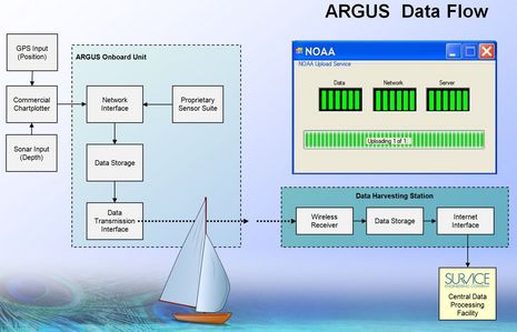
The concept is pretty sensational: The ARGUS (Autonomous Remote Global Underwater Surveillance) system would equip volunteer vessels with a custom WiFi transceiver that is connected to the nav system for GPS and depth, and that can automatically upload the resulting data files (when possible) to a shore server where it’s collated and quality controlled before being turned over to NOAA so it can better manage its dredging and charting responsibilities. If it all works out as hoped, the volunteers might even get the equipment for free and be able to use the WiFi connection for their own Internet needs…
ARGUS is the brainchild of engineering firm Survice, and has its own informative Web site here. The project was also recently covered in Yachting by my colleague Jason Woods. And the hardware is being built by Wave WiFi based on its heavy duty EC series. ARGUS is looking for volunteers both to test the vessel gear and to set up/maintain shore network bases, and I imagine the most desirable sites/users will be in the vicinity of major dredged waterways, as that’s the issue NOAA is definitely looking for help with.
But the fact is that NOAA needs lots of help. The HSRP report you can download here states that at NOAA’s current rate it will take 166 years to properly survey even just the areas routinely transited by commercial vessels! I’m sure that many of you, like me, would be willing to help collect data, and don’t even need compensation if the process is reasonably easy. Come to think of it, the ARGUS technology could also do tracking and security duties that many of us might happily pay for. At any rate, I hope it goes well.


Similar to what the Norwegian company OLEX has been doing for years, but with addition of WiFi and more online Updates?
See link here: OLEX
I have always wondered why some manufacturer like Garmin did not put this in their chart plotter product. It would give them the most up to date charts possible. Over time they would become the default charts. They could also develop quite a nice cursing guide type service. I can see a color coded map of where people tend to travel the most.
They could even offer customers future downloads depending on data uploaded; e.g., if a customer uploaded unmapped areas or undermapped areas then the customer could download the most current map of an area. This would give them a long term strategic advantage that could be priceless.
What a WIN-WIN proposition! This to me is the most exciting concept I’ve heard (and understood, mind you) since BB radar. I will volunteer TODAY to help.
My greatest hope is that NOAA will accept and vet and confirm data outside commercial shipping lanes and channels. Shoaling that fills channels starts in shallow water, and thats where an “early warning system” should show the changes engendered by storms and man-made influences. Since we will never cure this disease, preventative medicine is imperative.
This data must go to NOAA. It should not become proprietary in any manner because it is a matter of Safety of Life at Sea. Finding a single rock spire in cold New England waters could save a dozen lives.
I’m pleased to learn that EarthNC has joined the ARGUS team, with EarthNC providing “the
opportunity to demonstrate the complete cycle for the acquisition and distribution of ARGUS depth data.”
In other words, it sounds like we’re going to able to see the data collected during at least the Beta testing. The full press release should be online soon.
Also, Survice has been happy to hear from some potential volunteers today, but do note that Beta volunteers will have to purchase the WiFi gear, as mentioned in the Yachting article.
Maybe it would be possible in the future to use small floating buoys with AIS and echo sounders to transmit depth data to future AIS Satellites to NOAA database in a similar manner?
… also, I will volunteer. Let me know how. I leave for the Bahamas the end of Feb and can do the FL intercoastal on the East coast (both ways).
Why worry about wifi, just tap into a 3g/sat system like SPOT (globalstar) or 3G like the Amazon Kindle book reader. Wifi is a nightmare to setup and use and each and every marina is a mish mash of overlapping coverage areas, some requiring login, some not, the black box on the boat should be dumb simple for people to install and use.
I disagree that the information should go to NOAA. It seems that the best way to quickly get the data in people’s hands is to provide it right away, providing the feedback necessary that the people who are collecting it are actually making a difference. If NOAA get’s it eventually, great, but that shouldn’t be the limit of the scope of the project.
The next step would be to license to Garmin, Furuno, what’s left of Raymarine and pc based chart programs to provide as an overlay data type on existing and new breed chartplotters. By cutting the nav software companies into the revenue (I think a subscription based model would work great), they will be interested like they are with xm/sirius, to integrate into their products.
I also agree this could be a big deal for our industry, and would also line up to help get it rolling.
I doubt however, that a defense company can do any of this. It’s not in their DNA. selling a system to the DOD is more up their alley. I think a startup that is funded by internet and boat geeks has a better shot of making this work on a grand scale.
Bob, Spot is about the polar opposite of 3G cellular in terms of data capacity and speed; I don’t think it could handle what will be generated by ARGUS. The Kindle does use 3G cellular and could handle the data but no one really knows what embedded service like that costs as Amazon bundles it in with the cost of the Kindle and the content you buy. Besides, I’m not sure Sprint (the service they use) covers the coasts very well.
I do know what you mean about the hassle of coastal WiFi, but must add that Wave WiFi has about the easiest connection software I’ve seen to date. I’ve been testing a Wave Comet and will write about it soon.
As for the ARGUS business model, it seems like it’s up in the air. Personally, I’d like to see it distributed publicly and used by NOAA, and if NOAA wants to help finance the collection infrastructure, that’s fine by me.
I hope they plan on also tracking the exact time & date soundings are taken enabling adjustment of depth data relative to tide predictions.
I had an initial version of Olex aboard a year or so ago. It was a very interesting concept, and the results from some of our heavily traveled routes was amazing. Unfortunately, the Olex software was nowhere user friendly… I hope this new system is.
Olex have had the option to transfer depth over AIS for long time, and wood an solution like that be very fast to implement if land based AIS network is used to collect these depth.
Coverage wood also be many times better than what a WiFi network wood be.
ARGUS and Olex are quite different. Olex looks like an amazing onboard tool but starts at around $10,000. ARGUS doesn’t really add to a boat’s navigation tools at all.
I’m surprised about Olex’s purported ability to broadcast depth info “over AIS”. I tried to find out more at the Olex site without much luck. But I can’t imagine that it’s OK to transmit whatever you want over the two AIS frequencies.
Here’s a PDF of the latest ARGUS press release:
http://argus.survice.com/documents/EarthNC_ARGUS_Press_Release.pdf
Ben
Olex uses the addressed binary system to send the depth as a binary message to another vessel
Maximum of 2 vessels can swap depths this way and build the image twice as fast.
Olex starts at �3500 inc computer chart and screen.
When you start adding modules it gets costly.
Andy
Ben,
What I meant about taping another source instead of wifi is to bypass wifi by any other means that is delivered over a commercial providers background, thereby reliving the consumer from handshake issues. Spot is extreme low bandwidth, but irdium/globalstar and others could handle this data-stream depending on sample rate. A trawler going 7 knots doesn’t need to be updated every 30 miliseconds to get good data.
Also, you would be surprised how receptive all three major carriers are to do always on data deals. All this product needs is to store and forward data when in port.
Also, I’m curious how these guys will get a patent on this, as prior art was done on paper by every fishing fleet since homer.
Ben,
Thanks for the post. Great comments from your readers as well. It’s good to point out that beta unit cost is currently the burden of the tester. But we are also looking to see if there are ways to subsidize that cost.
We intend to let the industry and communities steer this ship. The demand for what ARGUS provides will determine the path that it takes to deliver. The ARGUS team (of internet and boating geeks) is providing the engine fueled by an unlimited supply of data.
John Hersey
SURVICE Engineering
I’m going to bet there is some resistance from NOAA and the Corps of Engineers, who would be worried that the data wouldn’t be as accurate as they want, or that a cheaper data source might compromise their budgets. I can just hear some Hill staffer calling them to check on this “scheme” and getting an ear full of pooh-pooh
(cunning double entendre here!)
I wish the White House could hear about it! Here’s a grass-roots plan to fill a pot hole long enough to avoid an accident until the road can be paved right. (I’m feeling particularly metaphorical this morning, better check my meds.)
NO! WAIT! I just did it! NSA now has alarm bells ringing because somebody use the words White House and Pot in the same sentence on the INTERNET!
Anyone who hasn’t used the Wave WiFi products has no idea how easy they are to set up and use. They also have the best Marina AP’s I have ever installed.
Bill Lentz
As happens so often, similar ideas spring up in different areas at the same time. In Europe we are involved in a similar project, but differing in that it either uses PC software or a NMEA0183 data logger that writes to a USB memory stick for data upload once ashore. We will be recruiting people to log data from around the end of April – although we are initially concentrating on trials area in the south coast and Thames estuary of England, Brittany in France, and Lithuania in the Baltic, we welcome data from anywhere in the world. For more information on the project as a whole, see http://www.cosudec.eu/ and for the recruitment of volunteer loggers see http://www.teamsurv.eu/ — click on the more info button or register on the Teamsurv site to be kept up to date as the project progresses.
Tim Thornton
Yipes…the nattering nabobs of negativity are tearing up the idea of volunteer data collecting on the rec.electronics newsgroup:
http://groups.google.com/group/rec.boats.electronics/browse_thread/thread/a1ab2465e0fc5a5e?hl=en
For those that are interested, last week we posted several solution sets for ARGUS data acquired (thanks to our beta testers!) from the spring of 2010 through August 2011 on the web site at http://argus.survice.com/. Just click on the Downloads tab. There’s also a link to a free CARIS viewer.
We’re looking for boaters’ help in looking at the solution sets to get feedback on how the results look compared to the charts and local knowledge. We’d appreciate your feedback to [email protected] or you can get to us through the Contacts page.
John Hersey
SURVICE Engineering