
New Garmin GPSMap 700 series, sweet spot!
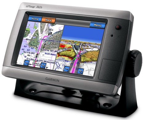
Let’s see…a 7-inch, bright, WVGA-resolution touchscreen with built-in GPS and support for Garmin Ethernet radars and NMEA 2000…all at a base price of $1,400? Sounds like a sweet spot to me. I can think of many boaters who will be interested, and few comparable choices…
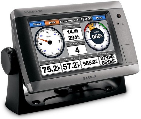
The GPSMap 700 series was announced today and Garmin also put up a buzz site, but the four new MFDs are not yet on the chartplotter page (which is getting to be quite the list). I don’t know when they’ll ship, but do know that an extra $100 gets you pre-installed U.S. charts and $200 a built-in fishfinder. One thing I notice on the screen below, and on several more you can check out on the buzz site, are numerous new ways to display engine and other instrument data. They look interesting, and it seems reasonable to expect that Garmin will migrate these features to their other MFDs eventually.


Garmin’s buz site shows the radar connecting to the N2K bus. That’s either an editors booboo or a real teaser. I seriously doubt the latter….
Yeah, I asked Garmin about that, wondering if there was some N2K magic I didn’t know about. But it’s a drawing mistake, and the drawing will change soon. The 700 series has a single Ethernet port, but Garmin is going to call it a Radar Port so people don’t get confused and think this MFD can be networked. It can’t.
It could be networked with a port expander
These look like pretty sweet little devices. But now that they’re on software version 8.4 or whatever isn’t about time that Garmin cleaned up their funky fonts, with their bad scaling and lack of antialiasing? Clear digital type is like 20 year old technology at this point. And readability really does matter on an MFD screen, especially with the amount of clutter on vector charts.
@Adam: Exactly! I cannot really understand how people put up with these devices that do not know how to do anti-aliased scaling properly.
Compare a chart software that does it well with one that does not do anti-aliasing, and you will notice that with the former you can have roughly twice the area of chart displayed without loosing detail.
This translates to better overview and safer navigation!
“It could be networked with a port expander.”
How can you presume that, Glenn, when it’s not Garmin’s intent?
Nice hardware,but….I wish Garmin would bite the bullet and give up on Bluechart and run Navionics and/or C-map.
(i hear they are still having problems releasing the fixed G2 vision).
“Compare a chart software that does it well with one that does not do anti-aliasing, and you will notice that with the former you can have roughly twice the area of chart displayed without loosing detail.”
Names would be helpful – who does & who doesn’t.
I’m getting ready to buy a 12″ plotter because I can’t read the damn screen, even though I’m on a sailboat and would like to limit my power budget. Thanks.
Ben,
what’s with the fine print:
“Garmin requires professional installation for the GPSMAP 700 series. The GPSMAP 700 series will be made available through NMEA, CMET and ABYC installing dealers only. ”
No user installs?! How hard can it be?
Ben,
No mention of VHF Class D connectivity? Is it simply assumed that all newer MFDs have the feature?
I think that’s true, Butch, at least via NMEA 0183, and I think Garmin has perhaps taken the lead in terms of VHF integration over NMEA 2000.
Carib, I’m looking into that.
A little birdie responded thusly to my possibly unwise “few, if any, comparable choices” phrase above:
“Might I suggest: Lowrance HDS-7m Insight USA, which is comparable screen size and resolution, is $1,000 (Garmin is $1,500 with built in mapping), and the HDS-7 Insight USA combo with Broadband Sounder is $1,200 compared to theirs which will be $1,700. HDS has full Ethernet networking not just radar, and it also supports StructureScan. And of course, Lowrance has been doing NMEA2000 networking AND anti-aliasing for years.”
In the future, Garmin should give the Panbots first crack at the marketing literature. Then we can find the little mistakes like the Radar on N2k bus! 🙂
I really like the bar graphs for RPM, fuel burn, fuel level and trim. Now lets see the rest of the engine gauges displayed the same way! I really think our brains will interpret the engine data much better on a bar graph. Maybe my brain is just wired a little different…
It would be a shame if it does not network when connected to a Garmin ethernet hub. I could see this device on a lot of tuna towers, with the larger more expensive displays down below. When installing in a trawler, I would rather put two of these units side by side above the windshield, rather then have a single larger display in a Himalaya. I think that makes a cleaner looking helm, and that leaves more room to spread out the paper charts that you hopefully will never use.
Carib, I don’t understand that language, and can’t figure out where you found it, but Garmin says that the 700 Series “will be available through most of our marine dealers as well.”
My understanding is that distribution of the new 6000 and 7000 series will be more limited than usual, i.e. installer oriented, but that makes more sense.
The 700 series should not be confused with the 7000 sereis. The 7000 series is limited distribution not the 700.
In regards to DSC VHF … you can connect the plotter to any standard marine VHF using NMEA 0183 connectivity. If you so choose you can purchase one the new Garmin VHF’s. The VHS 100 (NMEA 0183 certified) or the VHF 200/300 series that are both NMEA 0183/2000 certified.
The VHS 200/300 series use embedded NMEA 2000 functionalty when connected to your Garmin chartploter.
When connected via NMEA 2000 your Gamin 200/300 and 500/700/4000/5000/6000/7000 chartplotters sereis can be interfaced to set up individual calls (i.e. you can initiate VHF calls from your Garmin chartplotter).
As a safety measure you can initate a man- overboard distress call from your radio, your Garmin chartplotter will display the man overboard screen and prompt you to navigate back to the man-overboad symbol. If you have a Garmin autopilot system connected to the your NMEA 2000 network, it will prompt you to start a Williamson turn to the man-overboard symbol.
This is a nice addition to the Garmin line and fills the void they’ve had for a number of years in the seven inch display market.
Tom
The new G2 Vision Charts will be released in short order. There are some new looks.
http://i676.photobucket.com/albums/vv129/bluewaterpirate/Garmin%20Album%201/GarminMapping-1.jpg?t=1262984472
Here’s some more information.
http://www8.garmin.com/buzz/gpsmap700/
Yes we just installed the Lowrance HDS-7 as a control panel NMEA 2000 hook up from a Yanmar 4jh2e on a sailboat to read engine data… it also functions as a backup chart plotter with its own built in GPS antenna. This is backing up the new NSE-8 Simrad MFD as the main MFD… both run Navionics charts. The Lowrnace will show RPM, temp, oil etc. Has not had the sea trial yet, we are just now finishing the install which includes all Simrad equipment. Airmar PB 200 and sounder, IS 20�s, AP 28 and 24 autopilot. As far as the Lowrance vs. the Garmin, I like the fact that the HDS uses the same chart as the Simrad NSE-8…but not as user friendly as the Garmin overall.
Very nice. The next time I am in front of small Garmin I hope it is this one as the last 545s I was using was murder on my fingers.
It would seem to me that extra steps were required to disable network capabilities, to limit this unit to radar only. In my case, I would have to buy another ($600) XM receiver to add a 700 to my setup.
If this unit is a descendant (ascendant?) of the 640, rather than a subcendant (!) of the 4000/5000 series, I could understand, but I would still wish they could have given it full network features. This is a right-sized unit for a host of applications.
Hey, Dan; I didn’t understand “murder on my fingers”; were you engaging in hyperbole?
I don’t see any mention of AIS anywhere on the Garmin site, am I missing something?
Baz
Absolutely it’s AIS capable.
http://i676.photobucket.com/albums/vv129/bluewaterpirate/Garmin%20700/Garmin700AIS.jpg?t=1263327528
Well, we have a nice gift from Garmin
GPSMAP 720/720s software version 3.00
as of October 20, 2010
Changes made from version 2.50 to 3.00:
◦Radar:
◦Added Radar Overlay display functionality, which draws returns from a connected Garmin GMR radar over either a Navigation Chart or Fishing Chart presentation. This feature is available as Charts > Radar Overlay or Radar > Radar Overlay. Garmin recommends using a magnetic heading sensor for the best Radar Overlay experience.
◦Added the option to overlay radar returns on 3D charts.
◦Added ability to measure distances on radar displays in the same way this can be done on 2D charts.
◦Corrected an issue where changing the system units would result in inaccurate radar range ring measurements. Range ring measurement accuracy would be restored following a power cycle.
◦Charts:
◦Added support for TOPO maps.
◦Added a control for selecting between two map vehicles and multiple sizes on 2D charts. On the Navigation Chart, select Menu > Navigation Chart Setup > Chart Appearance > Symbols > Vehicle Icon.
◦Added option to use GPS Heading information when drawing the Heading Line on 2D charts. This is useful for sailboats and other vessels that have a heading sensor but don’t always move in the direction their bow is pointing. Note that GPS Heading is unreliable at vessel speeds near 0 knots (speed over ground).
◦Moved 3D range ring labels to the side so they don’t obstruct the view ahead of the vessel.
◦Added support for updating the internal basemap.
◦Changed text color from black to green for active AIS targets on 2D charts.
◦Improved presentation of AIS vessels and AIS vessel labels on 3D charts.
◦Improved visibility of AIS trails on 3D charts.
◦Improved display performance of the World Map.
◦Improved presentation of depth soundings on 3D charts. As depth soundings approach the horizon, they will be de-emphasized to reduce clutter on the display.
◦Corrected text display for charts that use Cyrillic fonts.
◦Corrected display of elevations for obstructions that are above water.
◦Corrected various drawing issues around the anti-meridian.
◦Sonar:
◦Added a depth log to the Sonar functions.
◦Added Pic Advance control to Sonar Setup menu, which allows the scrolling sonar picture to advance faster by drawing multiple columns on the screen for each sounding returned.
◦NMEA2000 & instrumentation:
◦Created an NMEA 2000 Setup control in the Configuration->Communications menu and moved the Device List into the new setup menu.
◦Added Label Devices under NMEA 2000 Setup which will allow labeling of NMEA 2000 engines and tanks with pre-defined names.
◦Added analog display options for tank levels, rudder angle, trim tabs, bow tabs, and engine trim.
◦Added option to display individual engine fuel flow rate and fuel economy numbers on the Numbers dashboard gauges page and in overlay numbers.
◦Changed the Engine Dashboard page automatic gauge configuration to only show the trim gauge if engine trim is available.
◦Added support for Yanmar information received via NMEA2000.
◦Improved autopilot and chartplotter synergy when more than one plotter is connected via NMEA2000.
◦Improved support for displaying destination waypoint information on GMI-10 instruments.
◦Improved support for displaying information regarding autoguidance routes on GMI-10 instruments.
◦User Data:
◦Simplified the user interface for creating new waypoints via Chart Menu > Waypoints & Tracks > New Waypoint and Information > User Data > Waypoints > Options > New Waypoint.
◦Added a prompt to delete unused route waypoints after deleting a route.
◦Corrected an issue where trying to move a waypoint while the waypoint review page shows a map doesn’t show the Move Waypoint menu.
◦Corrected an issue where waypoints created by pointing on a weather chart were being created at the center of marine warning areas, rather than at the location pointed to.
◦Other:
◦Incorporated higher-resolution system fonts for improved presentation and readability.
◦Improved weather drawing performance.
Great news and some good decisions by Garmin.
Downloaded today, will install on plotter tomorrow and then I’ll report back any issues that I find (or – hopefully – lack of issues 🙂
Installed from Windows 7 laptop to SD card – no problems.
SD card loaded onto 750S – no problems.
At this point I can only comment on chart plotting functions – don’t have radar yet nor have I installed sounder transducer yet, nit mapping and other plotter functions all seem to work well.
Thanks, Roy. I too have downloaded the 3.0 update (and the latest Marine Network update) and have lots of stuff to throw at the 740 on Gizmo. But it will have to wait until next week as I’m jammed getting ready for Lauderdale show. Incidentally, there’s a bit more on the 740 here:
https://panbo.com/archives/2010/05/garmin_2010_gpsmap_740_and_gmr_604_xhd_first_looks.html
I loaned the test unit to several locals this summer, and they all liked it a lot. I do too, and I think it’s been a big hit in the market.