
Furuno MaxSea TimeZero 2010, valuable dual Navionics/C-Map & more
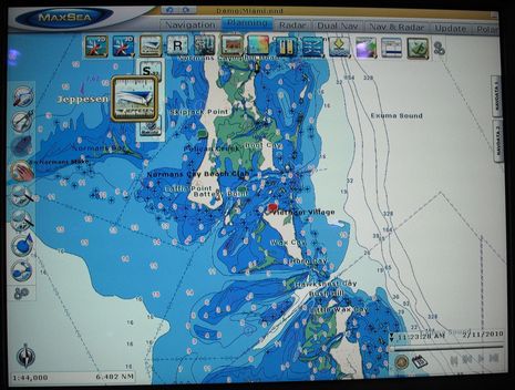
Last February Furuno made a lot of promises about improved charting in NavNet3D and MaxSea TimeZero, and it seems to be making good on all of them. At least the North American MapMedia versions of “C-Map by Jeppesen” vector charts (explained here) are now available, as are the NN3D 2.05 and MSTZ 1.9 software upgrades that can display them. Those upgrades purportedly do a lot more than make TimeZero the only charting software that can support both Navionics and C-Map cartography (given that Geonav’s “DualFuel” won’t be available here until Fall, and the fate of Raymarine’s similarly ambitious dual cartography plan is apparently uncertain.) But before mentioning those other improvements, I have some good examples of why you might want to have both Navionics and C-Map at your helm. First, click on that image above showing Jeppesen C-Map coverage of the Exuma Islands in the Bahamas…
Then look at the same area as covered with Navionics core data:
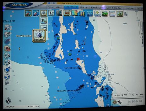 The difference in details is pretty stunning, but it would be wrong to conclude that C-Map has the best Bahamas data. I took these shots at the Miami Show using a beta of MSTZ and, as the icons indicate, it was dead easy to switch chart types. (The beta could also show Navionics and C-Map windows side by side, but I understand that the feature is not available in the finished update because one or both of the data providers doesn’t permit it.) And I think chart type switching on the NN3D MFDs will be just as easy, using the RotoKey. At any rate, it wasn’t hard to find an area of the Bahamas where you might very well prefer Navionics charts…
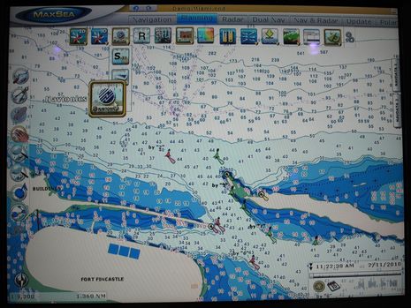 Jeppesen C-Map doesn’t seem to have the same level of detail for Nassau Harbor, though if Google is accurate, they did get the name of “Arawak Cay” (and maybe the location of Fort Fincastle) right:
 Now there’s no question that the Bahamas is a special case chart-wise, because there is no decent official H.O. data, so it will be interesting to see if there are appreciable differences between, say, the Navionics and C-Map MapMedia charts now available for Canada. It won’t be fair to compare screenshots made with anything less than the latest software upgrades, though, as according to the press release (and demos I saw in Miami) the look of all TimeZero vector charts, including the free NOAA ENCs, has been improved. Spot soundings are in whole numbers (man, I wish the fractional distraction would disappear from all electronic charts) and outlined for better readability — and colored red in danger areas if you want; “various objects have been redesigned to reduce screen clutter”; and much else.
My task now is to update the test MFD12 and MSTZ I’m reinstalling on Gizmo, plus load the ENC and 3D data updates that are also part of Furuno’s spring bonanza. I’m even going to watch the Furuno training videos, and I’ll report back. In the meantime, let’s please hear from other TimeZero users about the update process and the results.


Incidentally, MSTZ 1.9 definitely includes support for ActiveCaptain user-generated POI data, and some other goodies, as you can see in this PDF:
http://www.furunousa.com/ProductDocuments/MaxSea%20TimeZero%20V1.9%20New%20Features.pdf
But the Furuno press release about NN3D 2.05, link above, doesn’t mention ActiveCaptain. Still to come?
I’m running 2.05 on my MFDBB and unless I’m missing something there is no Active Captain option. Incidentally, since connecting the NN3D Ethernet network to my 3G router for Internet access wreaks absolute havoc on Navnet, the only way I could see to update the AC data would be via SD card. That’s if you don’t also run Time Zero; if you do I would expect that MSTZ could act as a “chart server” for the Active Captain data the same way it does with satellite photos.
Hmm… I have 2.05 on my MFD but installed it before the new charts became available. I looked all around the Furuno site but can’t find chart download links for existing NN3D owners. Were you able to find any, Ben?
Thanks!
/afb
Adam, I haven’t gotten MyNavNet going yet (working on it), but a lot of these new charts are free and downloadable direct from the product pages. A useful document is current chart load shipping on NN3D MFDs:
http://www.furunousa.com/ProductDocuments/Standard%20MFD%20Chart%20load%20as%20of%204-22-10%20%28active%29.pdf
Your Version 4 West Coast ENCs are here:
http://www.furunousa.com/products/productdetail.aspx?product=MM3-USV-001&category=Products+%3a+NavNet+3D+%3a+Charts+for+NavNet+3D
But I’m also planning to download the C-Map and new Navionics base maps, etc. here:
http://www.furunousa.com/Products/ProductList.aspx?category=Products+%3a+NavNet+3D+%3a+Charts+for+NavNet+3D&facets=Chart+Region~Worldwide+Base+Data
Guys,
The new software, both TZ Navigator 1.9 and and 2.05, has been a bit of a step backwards for me. Graphics problems with pop up data on 1.9 persist (Macbook Pro Parallels5.0 Win7) and my MFD12 now has problems seeing the radar and gps on startup. I now need to run install wizard to install them after every shutdown. This is a non Hub 101 install ( a D Link DES 1108 Ethernet hub was used instead) that worked fine before the software update and even for a few days after. Go figure.
Joe
Joe, I found that after the software update I had MAJOR problems — disappearing radar, MFD remote control pad not working — if the MFD network (which in my case connects the two helm PCs, DFF1, DRS4A, and MFDBB) was wired to my broadband router. I don’t know if this is because both the MFD and the router were both try to act as DHCP servers or some other issue, but I suggest you disconnect devices from your Ethernet hub one at a time until the problem (hopefully) goes away. As soon as I disconnected the broadband router (which still is connected to the PCs via wi-fi) the problems all disappeared.
As for graphics issues, I’m not surprised you’re seeing problems on Parallels; I never got emulation working properly. But I also have graphics issues running under Boot Camp: the screen crazes after some preferences settings are changed. This is usually minor and goes away within a few seconds. If not I can quit and restart MSTZ, which a few versions ago you couldn’t do without the MFD going nuts and setting off all kinds of “lost sensor data” alarms. So that’s some progress!
Thanks for the links, Ben!
/afb
Hi Guys,
Jo @ Adam,
Drop me a line and i can probibly sort you out as i have setup several systems like this all with no issues and latest sw.
I noted that if the MFD is off when MXTZ boot the radar / nn3d isnt detected.
Adam you MUST disable the DHCP server in your router drop me an email ([email protected]) and ill happily provide you with the settings i used on several boats over in the UK that all work perfectly 🙂
Andy
Jo,
Also i would do a full system reset (hold down the menu key for ages when turning the unit on)
this will make sure any old / corrupted settings files will be binned.
make sure you backup user data (tracks marks waypoints etc)
Andy
MaxSea does not support Macbook Pro Parallels 5.0 Win7. Quit complaining because your gasoline engine won’t burn diesel. MaxSea does unofficially support Boot Camp for Windows 7.
I just bought a Navnet system consisting of 2 MFD12s, radar, and weather. I major reason for buying the system was the future availability of the C-maps. I just installed the East Coast C-map on both MMFD12s and MaxSea Time Zero. I must tell you I AM VERY DISAPPOINTED. THIS IS NOT the same C-Map wide charts I purchased and ran last year on my old boat on a Sitex chartplotter. Last year’s charts had much more information and were much clearer…many of the heading lines are missing on these Maxsea C-map charts. In fact, the Noaa S-57 vector charts are better in my area (Tampa Bay)…they are easier to read and include more info on yacht clubs, etc. Jeppensen needs to take their name off this product or insist that Furuno/MaxSea deliver their product as well as other less prestigious vendors.
I have Active Captain working fine on Maxsea…however it is missing many marinas…especially yacht clubs that are included on the NOAA vector charts…and on Active Captain running on my IPAD Tides and Charts program…so that’s a mystery.
So it seems to me there is a bit of a conundrum here. Active Captain on an MFD or MSTZ requires an internet connection, but MSTZ and an MFD will not operate properly with a gateway router acting as a DHCP. Who will rule the net, the MFD or the gateway router?
The MFD needs the gateway router, but the gateway router does not need the MFD. Seems to me the MFD (and all other NavNet electronics) should be the ones to acquiesce and use the gateway router as DHCP. Turning the DHCP on/off on the gateway router whenever we want internet access, but don’t need the MFD/radar/AIS etc. is really a pain.
With regard to C-Map charts, there is no question that the C-map base map is enormously better than the Navionics base map. In my usage in the Caribbean and Central America, I have found that diversity yields the best results. At any particular location, the C-map, Navionics or raster charts may be more accurate. I think we should be happy that we have choices, though of course since none are free, most people will pick just one. For myself, I will chose to have both the raster and C-map charts whenever possible. Unfortunately they are not all available for all areas (e.g., South Pacific). If you are in US water you have the ability to add the NOAA vector and raster charts for no cost which is pretty sweet.
Hello,
You can get Bsb for a surprising number of areas. Maptech has Bsb charts for NZ and the South Pacific
http://www.maptechnavigation.com/water/digitalcharts/index.cfm?infopg=buy
There are also Bsb charts available for Queensland. I think I have most of the Bsb suppliers listed at
http://www.iexpedition.org/charts.html
Nick
Adam, Andy
Thanks for the suggestions. The problem with the NN3d is partially sorted. I can get everything running but if I shut down, then I have to wait about 10 minutes before restarting in order for the install wizard to find the radar and gps. I have done hard resets and reinstalled the update. I also found that the router was wired strangely (the equipment was on the boat when I bought her) and I will change that today and see if that fixes the problem.
The weird thing to me is that the system worked fine with 2.05 and no other changes for several weeks and then the problem arose.
Joe
FYI, my setup, Macbook Pro Parallels 5.0 Win7, ran fine with TZN 1.8., supported or not. I am confident that I will sort the TZN issue without further input from you.
Joe
Whilst not being an IP expert and also not having navnet, I do have a PC based network of 4 min pc’s and run a combination of switchs having provided static IP’s to my PC’s and Koden radar’s, wireless printer, this leave the DHCP serving requirement to ad hoc users on the network and this is provided by a router. So is it not possible to use static IP’s on the Furuno kit?
Michael
Owen, I’ve tried hard to make it clear that C-Map and Navionics cartography on TimeZero is not the same as what you’ll see on other systems, like here:
https://panbo.com/archives/2010/02/furuno_nn3d_now_with_c-maps_by_jeppesen.html
I do think that Furuno/MaxSea have plans to add more POI and other data besides the ActiveCaptain and Panorama sources now showing on MSTZ. I’m surprised you’re seeing less clarity, though, and I’m not sure what you mean by missing “heading lines”.
I’m also curious if you’re seeing C-Map custom marina maps, which are quite useful I think and should have made it thru the conversion process to the MapMedia format (I think).
Hi Ben. Aaron from Navionics here. I know you’re aware of this, but I just wanted to make others aware that our newest version of Bahamas Gold & Platinum+ has much improved detail in the Exumas and Bahamas overall. We can safely say that our detail is at least as good as the competition in virtually every area of the Bahamas from Long Island north. These maps should be assimilated into Furuno 3D units in due course, but we don’t have any solid information on that at this time. Thanks!
Michael:
No, it is not possible to use static IPs on the NN3D equipment. The “master” MFD always handles IP management for the radar, fish finder, and (in the case of the MFDBB black box) control pad.
I see two solutions to the DHCP conflict issue. Andy recommends turning off DHCP at the router. This will probably work and is easy enough, though it’s a bit of a pain to assign static IPs to devices like iPhones and iPads you may want to use on the boat. The other approach is to use a second network exclusively for Internet access. This could be either wired or wireless, and the router can handle DHCP for this net. The master MFD would have no route to this network.
The problem with the latter approach arises when you have devices you want to access from both nets, but that only have one port. Deck cameras are one example; the MFD needs to see them in order to put a camera on the screen, but I also want to access them remotely when I’m off the boat. I’m researching an approach that uses one of the PCs, which is connected to both networks, to route certain packets between them.
Nick – are you suggesting that MSTZ will display off the shelf BSB charts?
>I have Active Captain working fine on Maxsea…
>however it is missing many marinas…
>included…on Active Captain running on my IPAD
It all uses the same database so if all devices are synchronized at the same time, they’ll have the exact same data. Perhaps it’s possible that you turned on ActiveCaptain but didn’t do the Update process to get the latest info? I think the base database that is included with MaxSea is from a few weeks ago.
ActiveCaptain is going through a huge increase in data generation right now because of all the new users. We’re averaging over 1,800 updates every day now and it is probable that the new data will just appear when you perform the update process.
Adam – I think the NN3D equipment will use any DHCP server, it’s standard TCP/IP stuff, they can’t tell who is dishing out the address. There is an option in the MFD setup to turn off the DHCP.
The problem is that when offshore and the internet router will typically be off, then the MFD DHCP needs to be on.
Furuno/MSTZ distribute updates, charts and now POI data via the internet. It would be nice if they could come up with a solution that lets the MFD co-exist with the internet router rather than today’s tussle over who gets to be the DHCP server. Perhaps a smarter MFD that determines if there is a DHCP server present, and then becomes one if there is not.
FurunoTech – where are you?
Russ,
As has been said many times by everyone MaxSea TZ will only display MM3D charts.
the rasters should be the same as the BSB data that is available as it all comes from the same HO offices from around the world and are scanned charts.
Andy
Hello,
Sorry – I was just replying to the question of raster charts in the South Pacific in general.
Re scanning charts – you don’t need to scan a paper chart to create a Bsb chart.
Nick
I just tested a new Furuno Navnet 3d system with Maxsea Time Zero all updated with the latest software and the CMAP Bahamas Charts on a boat with my dealer. I also agree with Ben that the Navionics data looks better in some areas.
We both agree an can now say that the chart presentation and appearance is better than the Garmin Blue Charts of the same areas I have directly compared.
The combination of Maxsea and Navnet 3D is amazing!
Dan
Andy/Nick: FYI, there are currently no MM3D raster charts or C-map vector available for the SoPac.
I guess if MaxSea doesn’t get around to making them available, I can use another navigation program and buy the MapTech versions. It’s just a very poor second choice.
While we now have some choices with MSTZ regarding chart vendors, it’s still important to remember that it is a totally closed system.
The MFD has no NMEA 183 I/O capability with regard to navigation data (waypoints, marks, routes, etc.) and their NN3D formats are not published, so the only choice in navigation software is MaxSea.
And the only charts that MaxSea will use are the ones that they sell, no third party charts.
, we are still at the mercy of what MaxSea/Furuno make available overall.
Incidentally, when Maxsea Timezero 2010 is released, it should be compatible with the Actisense NGT-1 NMEA 2000 PC interface.
Ben,
Thanks for your June 2nd response. Guess I missed fact that MaxSea would alter C-Map charts to fit TZ. By less clarity I am referring to the “parallel dashed lines which show you the channel”…these appear very faint on the Max Sea C-Map charts versus boldly on the Raster charts and by my memory, on other vendor versions of C-Map Wide charts. Also, the “bearing lines” which show you standard routes only appear when you are very zoomed in. For example, on the intracoastal waterway from R26 to R68 near the Sunshine Skyway Bridge at the entrance to Tampa Bay to the entrance of the Bradenton channel).
Another problem of “clarity” is that the color variation by the depth of the water varies with the degree of zoom on MaxSea…I have it set to show anything over 10 feet as deep (and hence display as a white color). This works on S57 NOAA ENC charts but MaxSea changes it, so the color depends on amount of zoom.
Unfortunately I am not seeing C-Map custom marina maps or any of the photos included in the standard version of the C-map wide charts I used last year.
Owen
Has anyone compared the C-Map, Navionics, and NOAA vector charts for Alaska? The only way I have to do this is to buy them. Currently I am just using the NOAA raster charts.
The DHCP(Dynamic Host Configuration Protocol) – Master selection and capability of the Navnet 3D MFDs allows one of the MFDs in a network to allocate IP addresses. This is exactly the same way that a broadband router performs the network management in most home and office networks.
Please know that NN3D was NOT designed to exist on the Internet for security and safety reasons even though it could and someday may. Indeed, which manufacturer�s MFD Network does allow a direct Internet connection at this time? Raymarine – NO, Garmin – No, Navico – No. One can argue the virtue of this decision but, the decision is based on safety for our customers. From a technical point of view, we need one MFD to be the DHCP server (Master) because a NavNet3D network is based on a class B (172.31.X.X) network. If you use another DHCP server, the default might be another network (usually 192.168.1.X) and this will cause a conflict on the NavNet3D network. Some components that are DHCP clients (Radar, MFD,�) would acquire the address of one network while other components with a fixed IP address (such as the FA30, DFF1, �) would be on another network and thus would not be able to communicate between each other. Moreover, we need to have one MFD set as the Master on any NN3D network for other reasons (SystemID, route/waypoint sharing,�). In conclusion you must NOT have another DHCP server on a NavNet3D network.
On the other hand, Maxsea TZ is designed to be connected to the Internet AND to a Navnet 3D Network at the same time or individually as either is available.
Knowledgeable Furuno Dealers understand that when a customer installs Maxsea TZ Explorer as part of any Navnet 3D Network, the ONLY way to successfully create the system is with two network adapters. Either two wired Ethernet Ports are required on the PC or one wired connection for the NN3D Network and an 802.11 Wireless Connection to the local router which is on the Internet. The latter is usually preferred for a Laptop and it does work flawlessly with very little configuration needed. Note that in the future, MaxSea TimeZero could act as a �bridge� between the Internet and the NavNet3D network to �push� information to NavNet3D. This would allow real time ActiveCaptain POIs, Updates, Images, etc. on the NN3D Network which is currently not available. We have some work to do in this area but, it is achievable within the current hardware/software platforms. Stay tuned.
The Chart Vision or �Cartographic Mission Statement� of Furuno/Maxsea with NN3D and Maxsea Time Zero is to provide a media independent way to distribute chart data and updates to anyone anywhere in the world without having to physically ship encrypted memory cards. In other words, the cartographic security is in the software and not in the hardware which is a leap forward in technology over any competitor in the MFD product range. In this arrangement, any chart, satellite image, 3D Database, Tide Database and any update for these files can be downloaded over the Internet at very high speeds! Please know that since the middle of 2009 the data is now hosted entirely by Amazon’s Hosting Service! The only limitation in download speed is at our customer’s side! At the same time and just as easily, this data can be loaded on a Hard drive, DVD, USB Stick and distributed freely… Every available chart can be downloaded by anyone reading this at http://www.mapmedia.com. Only Unlock Codes are needed to activate any chart area that is not freely available. Generally, any charts outside of the US require an unlock code.
Russ – Yes the South Pacific is last on the schedule for conversion to the MM3D format but, the conversions are now going very well and are almost completely automated! The Jeppesen South Pacific Charts WILL BE AVAILABLE BY THE END OF THIS SUMMER ACCORDING TO OUR SCHEDULE! Inquire with Furuno if you need the specific completion date for a specific region.
Furthermore, yes – the MM3D format is proprietary but we did this for technological reasons and not to gouge our customers. The unique MM3D format offers NavNet3D and MaxSea Customers very streamlined chart management (install, unlock,�) across multiple platforms. Our Customers can load any MM3D chart from multiple source providers without wondering how to load and unlock individual BSB, C-MAP NT PC, ARCS, Softcharts etc. Know that MaxSea �Classic� still uses this older type of distribution of individual formats. We have witnessed the frustration that these customers experience when we tell them that they must contact C-Map or NDI or ARCS to issue new unlock codes because they changed their computer and the charts are not appearing on their software anymore! Every NOAA Raster and Vector Chart, as well as the updates are still free for our NN3D and Maxsea customers, unlike some of our competitors! NOAA has also stepped up in the US and the latest Mapmedia Edition 4 Vector Library we just released adds over 60 new free vector charts. For example, Chesapeake Bay now has full coverage and the data is nothing short of excellent!
Furuno Tech
to push GRIB files readable on the Nn3D will be great.
What would happen if you change the internet router’s LAN address to 172.31/16 and make it do DHCP on the same network? This would make all systems part of the same network.
The only worry would be a) make sure the fixed LAN IP address of the router is different from the master MFD and b) Furuno does some weird stuff and DEPENDs on being the DHCP server for the Radar etc…
I’d say it’s worth a try!
Re: updated charts; is there a simple way of interrogating the chart data loaded on the MFD currently and using that info to down load the latest and greatest charts? Sort of like the software update process that Furuno uses, but extending that to the charts loaded?
I doubt it but maybe someone out there knows an easy way? Many thanks!
Kees, the problem I see with that approach is that both DHCP servers could be assigning identical addresses. AFAIK there is no way to limit the address range assigned by the master MFD, and thus no way to tell the router to limit the address range it assigns. The result could be that my IP camera is assigned 172.31.3.23 by the router, even though the MFD has already given that address to the radar. Then I expect Bad Things would happen.
The approach recommended by Furuno Tech is the one I am now using. I just need a way to route requests from devices connected only via wifi (eg, iPad) to devices connected only via Ethernet (eq, IP camera). There’s no problem connecting the iPad to the PCs, as they both have wifi interfaces and so are directly accessible via IP addresses assigned by the router. The approach I am investigating for this is to have one of the PCs route between networks. XP will supposedly do this but it is, I understand, rather complicated to set up.
Michael, Go to Menu/Charts, then the “Data Catalog” submenu, and you’ll see a list of the chart files loaded on your MFD, even a graphic representation of the areas covered as you scroll the list. It’s possible that “My NavNet” makes the process of comparing what you have to what’s available even easier, but I haven’t figured My NavNet out yet 😉
Michael,
As Ben mentioned, you can check your MFD’s Data Catalog page and then use the other link that Ben posted to compare the current factory “Chart Load” with the ones you have in your MFD.
Here are the steps to determine if you have the latest revisions loaded in your MFD:
1. Compare the Last Two Digits of the Chart Name in the PDF with the last two digits of the same name in your MFD. If the last two digits are higher than yours, there is a newer revision available. For example, the US NOAA Vector Charts are now divided into two regions, SDUS00S57MAP04(USA EAST) and SDUS01S57MAP04(USA WEST). Click on the part number in the pdf to download either or both if you want to update your charts.
2. The PDF of the current chart load also has LINKS in the last column to download each individual chart region.
2. Here is the link to the PDF again(same as above):
http://www.furunousa.com/ProductDocuments/Standard%20MFD%20Chart%20load%20as%20of%204-22-10%20%28active%29.pdf
3. Click and download the regions that you would like to update. Then unzip the files to an SD Card and stick the SD Card in the MFD.
4. Open the Data Catalog in the MFD and click the Install Data button to install the new chart.
The new chart edition will automatically overwrite the old addition.
(Note that some chart names have changed since the original release of NN3D. If the chart numbers don’t match except for the revision numbers, you’ll have to delete the installed chart first.)
5. All of the vector charts will look a lot better and have more customization if you upgrade your MFD to the latest software revision as well. There are detailed instructions for updating the MFDs and Updating the Charts on the Furunousa www site for this process as well.
Furuno Tech
Furuno Tech: When will raster charts be available for the South Pacific? My inquiries to Furuno, and Furuno dealers, always have them 4-6 months out and you again make no mention of them. The older C-Map charts have a reputation on the cruiser forums (Cruiser’s Net, PPJ, etc.) for missing a number of atolls in the Pacific.
I’m sure we would all agree that the MaxSea/NN3D chart copy protection is much preferred to the dongle method, but it’s something the computer software industry figured out 20 years ago, it’s not exactly cutting edge. With regard to “gouging” customers, I think that you are the only one that has raised the issue. I believe most people understand that chart pricing is in large part driven by government licensing fees, or the lack thereof.
My issue with not supporting third party charts is coverage and accuracy. I’ve owned an MFD for over two years and Furuno is still making promises about chart availability. I think it’s very presumptuous to believe that MapMedia will always have the best charts, there is nothing in their track record to support that assertion. I understand that the charts need to be massaged to provide Time Zero performance. But there are cases where I would gladly give up performance to have an accurate chart. And unlike Garmin charts, the MapMedia charts have not always come with good tidal data.
The same problem exists with the MFD/MSTZ relationship. MSTZ has been buggy and unstable for most of the time since it was released, release 1.8.1 was a nightmare. I spent last season transferring waypoints from MSTZ to the MFD with an SD card dongle. Posts in this thread report problems with the most recent version, 1.9. But MFD owners have no alternatives since an MFD will not accept navigation input from any other source than the keypad.
I think as Apple has shown, if you’re going to sell an entirely closed/controlled system, it had better be awfully good. And even then, as Ben’s Android column made clear, the market appreciates some flexibility.
Furuno Tech, your post sounds defensive. What your customers are writing here is a combination of frustration with the current system, and an expression of what they would like to see in the future. Corporations spend thousands of dollars on focus groups and Ben is providing one for free. It’s invaluable customer input. Embrace it.
Geez, Russ, did you miss the long paragraph above Furuno Tech wrote just to you about those friggin charts!?!…
“Russ – Yes the South Pacific is last on the schedule for conversion to the MM3D format but, the conversions are now going very well and are almost completely automated! The Jeppesen South Pacific Charts WILL BE AVAILABLE BY THE END OF THIS SUMMER ACCORDING TO OUR SCHEDULE!…”
Geez, Ben. Did you miss that I wrote about RASTER charts? The Jeppesen charts are vector charts, earlier versions of which had a variety of known problems.
And let’s be clear that I, and I’m sure others, appreciate Furuno for participating in these comments. We don’t see much, if anything, from Raymarine, Simrad or Garmin.
I continue to believe that feedback and comments benefit both the consumer and the manufacturer.
I did miss that, Russ, sorry. It was a somewhat stressful morning. Plus I do feel somewhat protective of the manufacturers who dare to comment here. As you noted, it’s great to get direct input like Furuno Tech’s, and I don’t want to see such commenters scared away.
Andy, Ben, Furuno Tech, Anyone:
I recently installed the updates to MSTZ and NN3D. So I’m now running 1.9 on MSTZ and 2.0.5 on NN3D.
I’m now experiencing problems with the interface of the two. I have my network connected with a regular ethernet hub (not HUB 101 nor is it a router). To this hub I have the following connected:
Furuno FA 50
MFD 12 (with DHCP server turned on)
Sirius Weather
DRS 4D Radome
Laptop computer running MSTZ
I can run my charting software on NN3D and everything works fine, overlay is there, I can enter a waypoint and the autopilot will drive to the waypoint etc.
When I run MSTZ I get problems going. When I enter a waypoint it will drive the autopilot but it’s very hesitant and slow in responding. A couple of times it even started reversing the autopilot for no reason. When I start the radar on NN3D I will start to get the radar data over to MSTZ. However, it starts to display “External Demo” at the top of the screen. I have no control of the radar functions with the buttons in MSTZ.
I’m certain the radar image I’m seeing on MSTZ isn’t a demo because it looks identical to the radar image that will be on NN3D.
I called Furuno about this problem on Wednesday and they sent me a CD and told me to delete my previous install of MSTZ and install from the CD. I did that and nothing has changed.
Anyone have idea’s here?????
Thanks,
Jeff
Jeff, sorry if I am asking the obvious here, but you do have MaxSea *Explorer*, correct? That is, the version that connects to NN3D?
From Russ, via email (is any other registered user having trouble commenting?):
Jeff:
1) Are the problems only with radar and AP? What about other functions that require interaction between MSTZ and the MFD such as chart server, transfer of waypoints/routes, concurrent access to the FA50, display of boat instrument data, etc.
2) Try disconnecting everything except MSTZ and the MFD and check for AP behavior. Then add one device at a time, radar, FA50 and Sirius. See what works at each step.
3) Is the behavior different if MSTZ is started first, then power up the MFD?
4) Do a hard reset of the MFD (PITA because you lose all your settings). Don’t save/restore your setting from an SD card because the problem may be in those settings.
5) Sit on the phone with Furuno until it works. It’s ultimately their problem and in my experience they will take ownership of the problem and stay on it until it works, or they declare that the s/w has a bug. But you have to have the time and patience to sit on the phone with them during normal business hours when you probably have to do something silly like go to work.
Good luck and keep us posted! Russ
I agree with Russ’s comment #5, sit on the phone with Furuno until it works. They will stay on the problem until they resolve it.
I had a strange ‘issue’ with MSTZ 1.8 when I got it a few months ago. I was trying to create a bunch of routes that overlapped. Clayton at Furuno stayed on the phone until he could reproduce the problem and was then totally stumped. He told me that he would have to escalate this and call back.
I got a call later the next day telling me that he was still working on it but had no solution. A few days later he called again and they had indeed identified the problem as something that would need an update to resolve. He also gave me a workaround that not only resolved my problem, but actually works better than my original idea (which now seems sort of backward).
I’ve been watching and reading this blog about NavNet 3d for a while. Am planning on getting my system next Spring, perhaps April. My planned system is gonna be similar to Jeff’s as he stated above:
MFD 12 (with DHCP server turned on)
Furuno FA 50
DRS4D 4k 24″ Radome
Laptop computer running MSTZ EXPLORER
Can anyone comment about their experience with Furuno tech support? The comments here so far seem pretty good about them.
And will Furuno be coming out with a solid state radar as JRC has already developed? I would love to see Furuno start selling a BROADBAND RADAR with NavNet 3d.
from JRC –
Development of S-Band Shipborne Solid-State Radars Conformed with IMO Standard
Recently maintenance-free radars are strongly demanded by customers, because the use of radar has increased dramatically for ensuring safe navigation of vessels-consequently making the maintenance costs burden to replace their shorter-lived magnetrons. As if responding the customer demand, the International Maritime Organization (IMO) radar performance standard MSC 192(79) covering shipborne equipment shall come into force in July 2008; which will allow the new technology radar in the S-band frequency, in addition to the conventional pulse radars with a magnetron. In such circumstances, JRC has developed an S-band shipborne solid-state radar for the Safety Of Life At Sea (SOLAS) vessels. This radar has adopted the pulse compression method; for which we developed a several hundred-watt transmitter-receiver unit and the signal processing unit to realize the pulse compression technology. We have confirmed that our new radar achieves as sufficient performance as the conventional magnetron radars, through the field evaluation on a practical vessel.
Finally getting back to this issue. Hadn’t resolved it before a required recent surgery so the dilemma had persisted.
Yesterday I got a phone call from Iker at Furuno asking me if the problem with MSTZ 1.9 and NN3D talking had been resolved. I told him no and explained that I firmly believed data was coming from the NN3D to MSTZ as I could get position data and the radar image from both were identical. However, the MSTZ wasn’t talking to NN3D.
I explained I had just had surgery and hadn’t had the opportunity to get to the boat and do additional troubleshooting. He told me no problem. Said he would send me an email with some suggestions and to let him know if they worked.
Well here again it kudo’s to Furuno tech support. They cared enough to follow up and find out if the problem was resolved and then told me how to fix it. So I decided today that I would trudge to the boat and see if his solution worked as I had the feeling it would.
The problem was so simple it floored me and I couldn’t believe I hadn’t thought of it. The problem was not MSTZ or NN3D. It was my firewall, it was preventing two way communication. Once the firewall was disabled everything started working like it’s supposed to.
Hats off to good tech support from Furuno.
Ralph – I think you have your answer from Jeff’s post.
WRT solid state radar, certainly nobody but Furuno knows the answer to that question. My own perspective is that “broadband” radar is marketing hype. Sort of like when all the software products had a “turbo” version.
JRC’s assertion that they have “achieved as sufficient performance as the the conventional…” doesn’t seem to suggest any breakthroughs. I think advances in radar imaging will continue to be made with improved image processing capabilities, but a breakthrough antenna that delivers more information to the image processing would certainly be welcome.
Broadband Radar is marketing hype? Russ, how can you say that about the only recreational radar with an entirely different core technology? The Simrad/Lowrance BR24’s instant on, low power draw, low radiation, and extraordinary close in range resolution are not hype; they are pretty easily understood technical facts.
But the BR is just one very specific implementation of solid state radar, and as I saw last summer it’s not all that good past about 3 miles. (It will be interesting to see the 2.0 improvements this summer.) As we glimpsed with the Honeywell experiments, it seems quite possible to build longer range solid state radars with remarkable resolution:
https://panbo.com/archives/2008/11/honeywell_pc_ss_radar_wow_again.html
And I’d guess Furuno and others are working on making such radars practical, while also using better image processing to squeeze better performance out of magnetron core technology (as you noted). I imagine all marine radar will be solid state of one sort or another eventually.
Ben – I’m not sure what your point is. You seem to make the case that BR has solid state, therefore it’s not hype, but then you point out it’s weakness past 3 miles. Are you saying that the BR moniker is merited because there is some new technology, irrespective of the performance?
To clarify my own point, I expect continual improvement (“Kaizen”). I expect each new model to be better than the last. Giving every new model a new category classification is a marketing technique to make the product seem unique, it’s positioning in the classic sense; it implies everything else must be “narrow band”. But if you try to create new classification for a product that doesn’t deliver, then it’s hype. It’s a bit of an oxymoron to have “broad band” deliver only equivalent or poorer performance than regular radar.
I’m sure that while navigating around the Maine fog, the 1-2 mile range is quite important. In my own sailing, I’m more concerned with the information at 5-25 miles so I guess I’ll stick with my “narrow band” for now.
Russ, I also pointed out that the BR24 is superior to other radars in several areas, like power usage, radiation, and nearby range resolution. The point is that it’s based on a unique technology for recreational radar and to dismiss that fact as marketing is just silly.
I’m not crazy about the “Broadband” name, though it’s somewhat apt as the BR24 does use a slightly wider frequency band. But no one needs to feel that their conventional radar is inferior. In fact if you read the Broadband Radar Guide you’ll see that Navico’s marketing people are pretty honest about it’s pros and cons:
http://www.simrad-yachting.us/en-us/Products/Broadband-Radar/
Can I hook up a second ECDIS that is on my laptop to Ethernet hub 101 and receive the all the data to run the second ECDIS?
MFD 2.06 release notes
anyone managed to download this yet usa still giving out 2.05
http://www.furuno.se/fileadmin/user_upload/Media_Files/SE_files/Softwares/NavNet_3D_version_2.06.pdf
That’s interesting. But rather than tweak the MFD, I’d prefer they fixed the glitches in Maxsea Explorer.
Explorer does not have calibrated boatspeed when hooked up to Furuno instruments (The MFD does though.)
And the software uses the current data inaccurately to calculate Course-to-Steer. Without fixes for these, the routing module is pretty useless.
Robert – could you please expand on your comment?
My understanding is that the routing module uses the polars, not real time boat speed. While I certainly agree that MSTZ should display the same speed as the Furuno instruments and MFD, I don’t see how it applies to the routing module.
I assume you’re referring to the downloaded current data – could you also please expand on the problem with the application of that data?
A very late reply. Sorry Russ.
You are correct. The routing module uses small time-steps and so deals with the currents OK.
A problem with the currents occurs if a route leg is several hours. The calculated Course-to-Steer is then wildly inaccurate. Since I posted, 1.9.6 now includes ‘reverse specification engineering’ to fix this. Well, it’s not a fix – rather an acknowledgement that it didn’t (doesn’t) work as originally intended.
A year on, MSTZ 1.9.6 still does not allow calibrated speed off Furuno instruments. This affects ETA in the navigation window. (As does the dud CTS and calc SOG, as above.)
I wonder, are there identical problems in Trident?
Picking up this thread after a year and a few more miles under the keel.
I completely agree that Furuno/MSTZ have not produced a truly integrated system. The FI-50’s, MFDs and MSTZ do not work off the same page, don’t share calibration data, calculate computed data differently, etc. It’s a missed opportunity, but apparently a concious decision as they continue to add features and fix other issues.
At the same time they’ve kept the MFD and MSTZ essentially “closed”. The most compelling thing about using a Furuno MFD with MSTZ is that you only purchase charts once, not once for your PC software and again for your plotter.
Regarding the automated routing, I’ve concluded it is of no use to anyone other than Vendee Globe type sail racers. Beyond the fact that it’s perfectly happy routing a vessel through land, it needs to add a whole other set of functions to be useful for a recreational boater who has many more options than a racing sailboat. It’s another opportunity, but apparently not one they are interested in pursuing at this time.
Beyond these shortcomings, I helped a friend move his boat from Tahiti to Raiatea a few weeks ago with another vendor’s system, the same vintage as mine. It had networked MFDs, radar, etc. but it was dramatically more difficult to use, slower to respond, etc. than the Furuno/MSTZ solution on New Morning.
But, despite it’s shortcomings, the routing does provide interesting information on occasions. (It’s a pity that this is information that you might expect from the standard package.)
If you create a polar file for a motor boat, say 6 kts in all winds and angles, it will calculate an efficient Course-to-Steer based on the tidal currents. With high oil prices, this should be a winning feature.
HELP
i have Maxsea version 1.9.6.
the answer is probably so basic but i cant figure it out.
I need to activate regions to get details of the areas.
I have paid for them and have the disks and they are loaded on but somehow have de activated.
Under planning i have all the regions activated but as soon as i go into navigation i only get a few.
How do i activate regions in navigation?
I would contact MaxSea regarding your statement that they have been deactivated. Check the Activate Modules/Data pulldown to see what you have registered.
You can also log into My Maxsea to see what is registered for your system. (https://www.maxsea.com/my_maxsea)
Don