
Geonav, the giant roll out
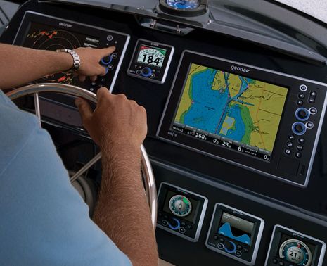
Geonav has been talking about a Fall U.S. roll out for some time, but now it’s turning out they have a lot more to show than the G12 and G10 MFDs introduced in Europe last year. Seen in the photo above is an even newer model called the GIS10, and while it and the 12-inch model include most all the features seen online for the G series, they also support NMEA 2000, Gigabit Ethernet, and, yes, the Side Imaging technology pioneered by sister company Humminbird. And how about those sexy MID 110 multifunction instrument displays (and the matching autopilot head)?
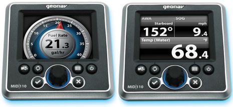
I have a draft copy of a large Geonav product brochure that should be printing soon, along with some closeups of those MIDs, and though they may be photo-shopped a bit, this sure looks like an interesting do-it-all display design. Check out the six-button-and-knob controls, for instance, and be surprised by the data ports on the back: NMEA 0183, NMEA 2000, and Ethernet…
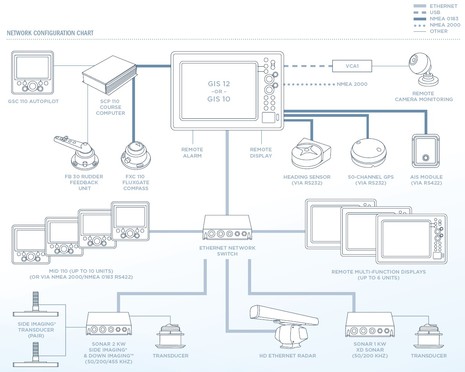
 Geonav is not yet saying why you might want to use Ethernet instead of NMEA 2000, as in the system diagram below, but I’m surely curious. The diagram also illustrates how the GIS 10 and 12 use blackbox Side Imaging and Sonar, whereas the G 10 and 12 have Sonar built in. And the brochure’s screen images, some available at Geonav, suggest that there’s an interesting human interface at work here. As best I can tell, few people have had much experience with this interface yet because the G 10 and 12 didn’t get shipped when originally planned. But I’m told that the production lines are now rolling down in Alabama (yes, though Geonav was originally an Italian company, the new MFDs may be the only ones built in the USA)…
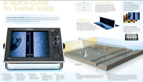
 I also think the brochure’s graphic explanation of Side Imaging is the best I’ve seen yet, though after spending the summer with NSE StructureScan on Gizmo, I think a cruiser or fisherman can pick up the nuance, and value, of this technology fairly easily. At any rate, I think it’s great that there are about to be two bigger boat systems that offer detailed side viewing (even if Humminbird and Geonav are still a little miffed about it.) And I’m certainly looking forward to Geonav’s big roll out to the industry at the NMEA Conference next week, and to the public at Fort Lauderdale a few weeks later. I’ll report on what I see, and also try to let you know when the new new stuff goes up on the Geonav Site.


“Geonav is not yet saying why you might want to use Ethernet instead of NMEA 2000” – hopefully the answer to that is simply that they will be embracing OPEN standards instead of closed and proprietary databuses. If Geonav publishes their protocols, and makes them open, and freely available, they could win.
Ethernet for full-color TFT MIDs makes sense, going forward. Think full-color video on any of the MFDs. Same for the other high-bandwidth items.
The 0183 orgy does NOT make sense, nor the fact they don’t show a single 2000 device. 2000 is here to stay and makes sense for non-high-bandwidth items, get with it. The camera should also be ethernet unless “VCA1” is a conversion box with an RCA/BNC cable connecting the camera itself… even then, it makes more sense to throw it on the ethernet I believe.
“Geonav is not yet saying why you might want to use Ethernet instead of NMEA 2000”
Because we are all sick and tired of proprietary marine industry “standards” that are talked about for years, poorly implemented and then, lack interoperability between manufacturers. If you don’t understand this, you will find success working in the marine industry.
Is the new GIS dual map capable (Navionics and C-MAP 4D) like the G series?
Nick, The GIS10 and 12 support Navionics Platinum and C-Map 4D just like the G10 and 12. I’m looking forward to seeing 4D for the first time.
Ray, what’s with all the negativity this morning? Maybe I didn’t explain it well, but as I understand it the owner of a new MID 110 can choose data from NMEA 0183, NMEA 2000, or Ethernet sources. (I asked about data bridging and while it’s not in the initial version, it’s on the road map.) 0183 and 2000 are both imperfect but they are soup-to-nuts standards, hardware protocol right up to specific marine data messages. Ethernet doesn’t have a marine data standard on top, which is why its use on the MID is a question mark. I’ll guess that Patrick made a good guess.
Looks slick. I had the pleasure of playing with an older Geonav on an Italian-built Biaia 43 this summer and it was a decent UI.
I love the idea of Ethernet on the small MFDs. Now that they are truly that – little sisters of the larger multifunction displays. As pointed out, it opens up the displays for a ton of functionality, such as video monitors, “classic” sonar, etc – all things that NMEA 2000 can’t do (it shouldn’t do) but you’d easily want on a 4″ screen. Engine room cam on a 4″ screen – perfect.
Can’t wait to get my hands on the new gear, and see how “installer friendly” it is. Do cables have removable ends/removable collars (a la Garmin)? Right angles? Can you bolt/screw the units in from the front, or do you need access behind?
What is surprising about the connection diagram is:
1) The VCA camera module doesn’t go into the ethernet switch, but right into the GIS 12 MFD – why?
2) Why do the GPS, AIS, and second heading sensor go in via NMEA0813?
Aaron, I don’t think that these new MFDs and MIDs share any technology with older Geonav gear. I believe Johnson Outdoors bought Geonav mainly for its European distribution network, and then started fresh putting together a line able to compete with the big four.
I don’t understand what Geonav’s deal is with the VCA camera, but I did hear from a Simrad guy in Newport that they weren’t “comfortable” enough with Ethernet video to include it in the new NSO architecture.
Ahh yes, “standards” in the marine industry. I suppose if I purchase a Raymarine NMEA 2000 device I can connect it to my NMEA 2000 network. Oh wait, SeaTalk Next Generation is not really NMEA. So perhaps I should spend another $40 on an adapter?
If Ethernet had these issues the tech industry would laugh it out of the room. Cat6 is Cat6 pretty much. True standards, globally used. Your computer, switch, router, VOIP phone ALL plug together using one cable type.
What’s truly disappointing is that the marine world, despite smart folks, can seem to move things like even the NMEA 2000 messaging formats forward in an slow way. The number of workarounds for AIS was embarrassing. This is tech from 1996/2001, so we are 9 years later now. I’m actually very curious about why it takes so long for NMEA to get on board with this stuff.
I for one am going to really work to support the folks offering standards compliant solutions, and will call out those putting unneeded twists in the mix.
When the term Ethernet is used; does this mean that one could use RJ45 terminated, CAT7 (new shielded)cable instead of proprietary terminated cables?
If used for backup/navigation cameras, I can see why they’d avoid ethernet, but in favor of a direct video connection to the MFD, not USB.
Regarding “ethernet” being more standardized than NMEA2000, I’d have to disagree. The electrical standards used by NMEA2000, CAN and SAE’s specs, are straightforward and easy to implement. It’s the messaging protocol which is what’s key to NMEA’s spec, and it’s relatively cohesive. Fault the slow takeup by manufacturer’s for N2k’s problems. Proprietary cabling is as much a problem with marine ethernet as it is with NMEA2000. After ethernet was created, manufacturers still had a ton of different protocols (read: proprietary PGNs) which caused interoperability issues.
NMEA needs to open up the spec to smaller manufacturers who want to try it ($$-wise, anyone can buy it), and improve the certification/testing process to make it affordable for small-time developers. The cabling has been slowly working itself out. No, $3000 is not expensive for a company who has funds and is committed, but then consider small-time developers or the complete process with certification and it can become an issue.
N2k is almost there, we just need a final cohesive push of manufacturers embracing the technology, and a couple changes by NMEA to make it what we want it to be. Only part of the delay is attributed to NMEA. Ethernet was developed in the mid-70s, it took to the 90s before it became the common standard. You had token ring in big use, LocalTalk on Apple products.
Ron,
Yes/No. The cables are shielded cat 5e/cat 6, and the connectors are based on RJ45. However, manufacturers such as Garmin, Raymarine, etc have used proprietary watertight & strain relief coverings for the RJ-45s.
I love the Platinum Tools EZ-RJ45 connectors, and they work fine with the marine gear.
My guess is that the Ethernet connection on the mini-MFDs is anything but an “open standard”. It’s probably just a way to connect the MID110s to a GIS that allows 0183 or 2000 data “collected” by the GIS to be available on the MID.
That’s what Furuno does with the Navnet3D MFDs (though not, apparently, on the RD33). In fact, you can’t connect more than one NN3D MFD to the N2K backbone; one connects to the backbone and the others get access to the N2K data via (Furuno’s proprietary) Ethernet.
I don’t think offering both N2K and this approach to Ethernet connectivity is a bad thing. It opens up installation possibilities for locations far from the N2K backbone, and means that the GIS’s current lack of 0183/2000 bridging is less of an issue (assuming they bridge N2K data to Ethernet).
/afb
When it comes to transporting high speed data, as applications like radar and sounders require, I would think there would not be any option to TCP/IP over wired ethernet or wireless. And I can’t imagine any manufacturer signing up to the constraints of a NMEA standard on how they manage the data transfer.
On the other hand, NMEA-2000 has to be the way to go for interconnection of lower bandwidth transducers and the like. Like Ethernet, it has multidrop capability – something that NMEA-0183 doesn’t. NMEA-2000 promises users choice of vendor for transducer and display products and through that choice we have driving competition.
I would expect that Ethernet is a way of getting broadband data to the mini-MFD’s which does open up great opportunity for video and sounder data display.
At least by the diagram we see that Geonav did not embrace NMEA-2000 for their Heading, GPS and AIS interfaces. Geonav have an opportunity to properly get behind NMEA-2000. I hope that they take it.
As Johnd wrote: I for one am going to really work to support the folks offering standards compliant solutions, and will call out those putting unneeded twists in the mix.
I agree, voting with your wallet will eventually get somebody’s attention.
Now if these guys could just do a touch screen/hard control hybrid like Raymarine I’d switch all my gear out. Nice specs on the unit, and I love the dual cartography aspect. With regards to the Ethernet aspect of the units – per the spec page the radar interface is via ethernet. I don’t know if there is anything else that supports ethernet on the unit. Ben – will you be getting “a setup” of Geonav at some point? I’d be curious how the HD Radar compares against the rest of the pack. We do a lot of multi-day passages when we’re out and if I was to replace my current Raymarine setup (my C70 being in desperate need of replacement) I’d want to know the entire integrated system is up to par with Raymarine, Garmin, Furuno, etc. I’d also love to know how the units stack up in real life against everything else you’ve tested (i.e. what’s missing, what doesn’t work well, what is superior over everything else). Lastly, have they talked about pricing at all? Is this a luxury setup? Or does it compare against the Raymarine E-Series and similar units? I love having more options!
And it also looks like the Ethernet is used for multi-device communications. Per their website, they have a GNS5 network switch (http://bit.ly/lMpciS) – “The GNS 5 is designed for networking two or more devices in the GIS system—with the ability to connect up to five instruments to an individual switch. Use multiple network switches in a daisy-chain configuration to connect up to 10 Ethernet-capable system components.”. I wonder if it’s truly ethernet and you could hook up a wireless bridge to the switch. I could only drool – one switch below, one switch up top, connected via wireless with no need to string cables (other than power) to the cockpit!
Chris, I’m definitely going to test the MID 110 display, which is shipping now, along with the G Series. And I saw HD radar running pretty well on the G12 in a demo last fall. I wrote some “big picture” stuff about that demo here: http://goo.gl/hdyxG
I’ve been really slow with a Part 2 entry about the radar, autopilot, and chart performance I saw — C-Map 4D looked great, I thought — but I’ll put that together soon. However, shipping of the fully networked GIS Series discussed above has been delayed until Fall.