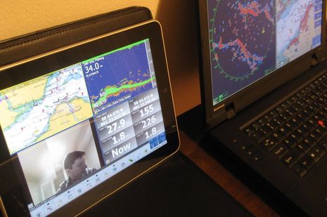
More on iPad as extra nav screen, from Nobeltec
It’s not just the new edition of Coastal Explorer that can play nicely with an iPad. In fact, it turns out that anyone running Nobeltec Admiral v6.5 or higher can get their iPad to show a variety of independent screens like the one above. (Right up through the latest 10.7 update, which apparently fixes numerous bugs, adds support for the latest Windows versions, and marks the welcome demise of Jeppesen’s Raster Plus Pack gaff.) That’s because Admiral has long supported the extended desktop capabilities of Windows, as well as touch screens. But Nobeltec Product Manager Bill Washburn, glimpsed in his own camera above, warns that screen refresh rate is marginal, at least at this point…
It turns out that Bill and his team have tested both apps that can send live PC screens to an iPad via WiFi, and found them both wanting. While iTeleport for iPad, which costs $25, is purportedly pretty fast, it can only repeat a computer’s screen, not extend it. Bill also reports that it requires separate VNC server software on the PC as well as a gmail account that it can use for authentication, which may not work if you’re offline. Avatron’s $10 AirDisplay, on the other hand, is “relatively easy to set up” and “seems happy to connect on a local WiFi LAN without needing to access resources on the Internet.” And it does support extended desktop screens, as shown above, but it’s slow, as in “nearly unusable when trying to stream radar, sounder or video,” writes Bill. I recall that the Rose Point folks also said that AirDisplay is too slow for radar and the like.
While AirDisplay might be useful for extended chart plotting or instrument screens (which involve less bandwidth and seemed to work fairly well on the CE setup I saw), let’s hope that Avatron or a competitor can speed up this type of utility app for better integration with a boat’s PC based nav system. Though there will be other ways to skin that cat, like Digital Yacht’s iAIS. In the meantime, I wonder how well a cockpit iPad worked out the racers who purportedly used them in the recent Figaro. I also wonder what the French man actually said that Google very badly translated as, “When they need a precise mapping, for example when they go knit in the stones, they can take the iPad knees while blocking.” Yike! Is there a human translator out there in Panbo land? And finally I will be very curious to see what Nobeltec unveils aboard their demo cruise during the Fort Lauderdale International Boat Show (aka FLIBS) this coming week, whether it involves iThings or not.


Nice entry, keep Figaro info coming! Free translation of that last sentence: When they need precis mapping, for example when sailing between rocks, they can just keep the iPad with them when they’re helming.
Man I love machine translation of idioms.
But iTeleport does not require a live Internet connection. I don’t know what authentication setting Bill was using, but like any other VNC client it works just find on a local LAN. When we’re anchored, I use iTeleport to repeat the RPCE screen so at night I can from my berth quickly flip on the iPad, check where we are in the swing circle, and go back to sleep. No visit to the helm needed and no need to turn on the power-guzzling computer monitor. Highly recommended.
BTW, Jaadu (the publisher) recommends TightVNC for use with iTeleport when the server is a Windows machine.
/afb
Hi Adam (and Ben)
When I installed iTeleport (with the associated TightVNC server on my Windows 7 laptop), iTeleport refused to open until I entered a valid GMail email account. And not just any email account on GMail (i.e. a [email protected], running on GMail) but rather an explicit [email protected] email address. iTeleport seems to reach out to GMail, at least at setup and initialization, to confirm that the GMail account is valid and accessible. Then it allows the user to connect their iPad to their Laptop. I paid $25 for iTeleport, so I was fairly irritated at this requirement.
As a Product Manager for Nobeltec I think a lot about features in our software, hardware and data products – specifically how our customers can use new features in a real life marine environment with limited to no internet connectivity onboard their vessels. Because of the inability of both AirDisplay and iTeleport to fully render cartography, radar overlay, sounder views and video displays across the Wi-Fi link it keeps us from giving a 100% recommendation of those products to our customers.
The reality is that Nobeltec customers can get their navigation software displayed on an iPad – the underlying technology for this has been in place within Nobeltec software for the past 8 years (as Adam points out).
If running Nobeltec navigation software on an iPad over Wi-Fi works for you then that is really fantastic – truly. But from what I have seen in testing, I would not navigate a boat in unknown waters with my family onboard using this technology.
I do hope the technology gets better and more reliable, as it is a really great implementation concept.
-Bill
Bill, while I agree that iTeleport’s UI is unclear on this topic, I found the following on the Jaadu web site:
Best,
/afb
—–“If running Nobeltec navigation software on an iPad over Wi-Fi works for you then that is really fantastic – truly. But from what I have seen in testing, I would not navigate a boat in unknown waters with my family onboard using this technology.
I do hope the technology gets better and more reliable, as it is a really great implementation concept.”——
Thanks for that. It appears many things are being shoehorned into the iPad. The iPad looks like it is getting closer to use for marine applications like charting but it is just not there yet. The fact that some of things needed to make it a viable navigation tool do not necessarily apply to the rest of the world there is a chance it may never be reliable enough.
When adding equipment that consumes power, that equipment needs to be able to provide something worth the power cost. Right now the iPad doesn’t reach that threshold.
Navigated from Ketchikan to Seattle all the way on Navionics ap iPad. Peak draw 2 amps at 5 volt. I would like to know of a plotter that draws less.
a little more precise translation:
“When they need a precise mapping, for example while manouvering between the rocks, they can take the iPad on their knees while helming at the same time”
Not impressed you can do that VNC app on iPad and any program running in your Windows / Mac portable.
I would agree with the warning voices in the comments above if this technology is used as the main chartplotter or the primary navigation device.
I haven’t used an iPad or even held one my hand but I have used a Windows CE based Panasonic CF-08 for 2 and a half seasons and roughly 3000 miles. These two devices aren’t identical but use similar technology and probably have some of the same problems. The main problem I have is with the screen update not being reliable.
You will be using a wireless network connection and a remote control or screen copy application with a server component on the PC and a client component on the device. The server (PC) component must hook the Windows display driver which runs in kernel mode and so has the ability to cause a blue screen. There is a bewildering array of remote control applications of all sorts and for all types of devices and all probably have one issue or another. Then there is the wireless connection for which there have been many problems reported around panbo, some out at sea away from possible interference (e.g. caused by inverters kicking in).
In my case these problems have led to the screen freezing on several occasions without me noticing immediately. When leaving our home bay, we often go around a small cape with lots of submerged boulders that are charted. The safe way is to go around a buoy but when I got the cockpit display, I felt safe and began cutting the corner, saving a mile. I checked the display five times a minute while going around the charted boulder. Because I had the boat to steer I did not notice immediately that the screen of the device had frozen while the screen below was alive and well. Of course the screen froze at this exact point not at any time during the previous hour while we were going in a straight line along the buoyed channel… And of course, when I later checked, we had gone exactly over the boulder. Had we hit it, rebedding the keel would have cost between EUR 5K and 10K and the boat would have been on the hard for half the season. And I wouldn’t have been surprised if the insurance company had refused to cover the damage citing gross negligence. This was not the moment where I felt most proud of my seamanship skills. I have later learned to avoid this problem but ever since then, I always check the AWA wind display in the instrument panel of CE (which is constantly changing) to tell if the screen is alive before I look at the chart area of the screen even so this incident was two years ago. I don’t think I would ever fully trust it again. So I will switch to a VGA monitor in the cockpit which is either black or shows the exact same screen than the computer below.
I also have problems with the device not standing up to the marine environment. My device is essentially broken after not much more than two seasons and I don’t really feel that I’ve got my money’s worth but this is a secondary problem for me. The boat is too precious to continue using screen copy technology with the primary navigation device for the time being.
I would certainly hesitate to compare a new gigaherz level dual core (cpu and gpu) based tablet, with SSD instead of conventional hard drive, that runs efficiently on 5 volts, and has an operating system designed for it from scratch, including thousands of apps vetted by the maker, with a two year old netbook of any sort.
Just completed my 6th offshore fishing trip running solely on my Ipad. Over a total of 150 waypoints and 290 miles without an issue. I did have my Raymarine Chartplotter on in the background, radar and fishfinder on as well. The Navionics HD app is absolutely stunning and navigation was excellent. The functionality and ease of use on the Ipad is excellent…I also was running bluetooth to the stereo. The refresh rate and speed really makes it easy. Sitting on the couch the night before going over routes also helps in the next days navigation. Now I know this will stir a debate about using the Ipad as my primary navigation tool(although I used my primary as secondary the last 6 trips) but if there is any questioning as to the accuracy and ease of use, I will put your minds at ease. Now all I need is to figure out a way to show 3d bottom contouring and a bluetooth connection to the fishfinder and radar!!!!