
Raymarine ST-STng converter, hand’s on #1 (GPS)
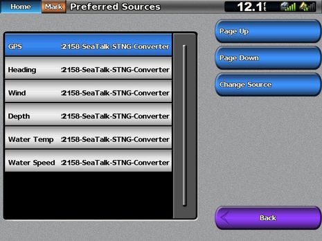
What this screen means: Since Gizmo’s current NMEA 2000 network has more than one sensor able to supply the types of data listed above, the Garmin 5212 gives me a choice of which source to use, and in each case I’ve chosen data that originated from Raymarine SeaTalk sensors and instrument displays, but was converted to SeaTalkNG (aka NMEA 2000) by Ray’s much-discussed-on-Panbo ST-to-STng Converter. Not only does the Garmin perceive all that converted SeaTalk data as valid NMEA 2000 PGNs, but it all looks decent when displayed, and I’ve done similarly successful testing on the Simrad NSE, Lowrance HDS, and Furuno NN3D MFD. So, despite Ray’s caution against using the converter on a standard N2K backbone, a whole passel of ST40 instruments are feeding Gizmo’s network, and getting power off it. And maybe that’s all you need to know, though I did get into some nitty gritty detail…
First off, it’s ironic that doing similar testing on a Raymarine E-Wide is hard, because Ray has not yet developed facilities for listing the data sources on an attached STng or N2K backbone, let alone for choosing among them. However, the E Wide will use the first depth, or wind, or whatever PGN it sees, and if that sensor fails eventually (or is unplugged), it will automatically switch over to another one. Which is good enough for most installs and users.
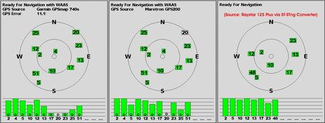
But I did see what may be minor glitches in the ST-STng data conversion, and today I’ll cover GPS, which is one of the hardest data types to translate as there are so many values, PGNs, and diagnostic oddities involved, as you’ll see. Below are three Garmin GPS status screens generated by selecting different sources on the screen at top. At left is what the 5212 sees coming in from a Garmin 740S (with internal GPS) that was running on the backbone, and, no surprise, all the subtle values like source name, Error distance, and Differential correction status per satellite are shown. The middle screen showing Maretron’s latest GPS200 — which I just got in for testing, and which is proving itself to be very able — has all the details except the Error value, and finally the Raystar 125 Plus coming in via the ST-STng converter lacks a source name, error value, or any indication of WAAS Differential corrections. But don’t jump to conclusions…
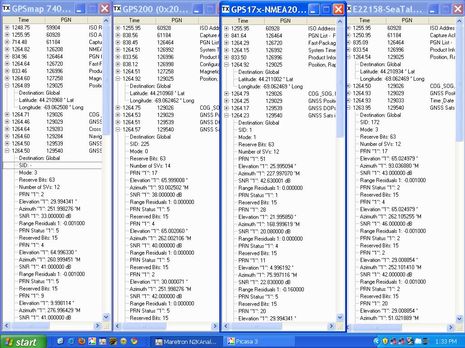
 The Raystar 125 claims to be a WAAS GPS, and I don’t doubt it. I think the lack of “D” notations on that screen is most likely a data converter problem, while the lack of an error value is probably a Garmin peculiarity. I say that because I puzzled over N2KView screens showing the exact PGNs being sent by those three GPS sensors (plus a Garmin 17x), and I also checked out how the PGNs displayed on other GPS status screens. In the screen below, for instance, you can see certain real time PGNs from all four GPS sensors. A significant difference, it turns out, is that the native N2K sensors are showing a “PRN Status” of 5 for many of the satellites listed in the long 129540 “Satellites in View” PGN, while the Raystar lists all as 2. Consulting the Maretron GPS200 manual — which, per usual, details PGN fields — I learned that 5 means “Used with Differential Corrections” while 2 means “Used in solution without Differential corrections.” So the Raystar/Converter is saying no WAAS, but does it mean it?…
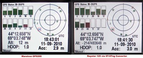
 Well, below is a Maretron DSM250’s status interpretation of the GPS200 and the Raystar. Note that both are labeled DGPS (though one is “3D” and the other an inexplicable “1D”). Note too the differential satellites 51 and 48 in red, and the very similar HDOP (Horizontal Dilution of Position) and Acc(uracy) figures. It sure looks to me like the Raystar is outputing a WAAS corrected position, even if it has the individual satellite codes wrong, even if it’s somehow confusing WAAS sats 48 and 51, and even if Garmin goes its own way in terms of position accuracy. But do check out the Raystar’s Altitude value, which puts Gizmo somewhere near the earth’s core! That same value is in the Raystar PGN, and it’s consistent every time I fire the unit up, so that’s a genuine glitch either in the Raystar or more likely the converter. However, most boaters don’t worry about altitude, and most displays won’t even show it. So what to conclude?…
 I’d choose a native NMEA 2000 GPS over a Raystar, simply because data conversion adds another layer of possible glitches, however inconsequential. But I wouldn’t worry a bit about going to sea with the Raystar and converter as the primary GPS on an N2K system. I’d like to have a backup, of course, but the accuracy shown by all these GPS sensors is more than adequate, even though none were mounted on deck with a completely open sky view. More important, really, is how well the rest of the Seatalk sensors worked with N2K via the Converter, because that means many boaters with existing Seatalk gear can start building 2000 systems without having to replace their sensors and instrument displays. More on ST-STng wind, depth, and heading soon.


By the way, I’ve tried several ways of installing the ST-STng Converter and they’ve all worked. But the setup behind all the screens above is probably the most extreme. The wind, depth/speed/temp, and heading sensors are all wired to their respective ST40 instrument displays, whose SeaTalk cables go to a couple of ST triple joiners and then to an ST-STng Converter. Which is daisy chained to another converter which handles the Raystar GPS and which finally patches to the NMEA backbone. In other words, all the SeaTalk gear, data and power feed, is on one drop.
What didn’t work very well at all was using an ST70 to bridge any of the ST40 data onto the backbone, even though it has the latest software. The data displayed on the ST70 OK, but it rarely made it anywhere else in the system.
ST70 doesn’t bridge the data, that little adaptor cable can be viewed as a one way street type of deal. Feed data to the ST70, it will not leave the display though.
There’s a reason the adaptor came into being!
Also, keep in mind the SeaTalkNG adaptor can be software updated, so hopefully the elevation is a non-issue in the near future.
I have been experimenting with the converter and 125 plus as well. Using the 125 plus my readings were even more strange than Ben reports. I had time data on the network, but lat/lon was never transmitted, even with the 125 flashing green.
I had more success using the converter to create an isolated seatalk network for several St60 Maxiviews. The MaxiViews all displayed wind speed and direction, SOG, depth, avg speed, etc. Everything looked good.
But I did experience weirdness with my ST 70s. One example: The displays locked as far as showing wind speed. Wind direction (and other data) was fine. I have some Furuno displays that showed the wind correctly, so I don’t think it was a problem on the network.
Restarting the network cured the problem, but I think this set up needs a new firmware to get the bugs sorted out. (I was using version 1.01)
I too have a newly “converted” Raystar 125 connected to a Lowrance LMF-400 simply to catch my fuel data on duel OB’s, via a pair of EP-60R’s. Unfortunetly, the Raystar converter is doing something funky with a known good position reported to the E140W. The Lowrance LMF-400 does show a flashing accurate position, but reads down below that there is no lock. Of course with an LGC4000 the accurate position neither flashes at 1hz, nor says that it has no lock. Needles to say, fuel managent system will not operate without a “good gps” signal acceptence.
I did a quick calculation on the negative altitude number shown by the Raymarine, and the vessel appears to be in orbit on the other side of the planet, about 125,000 miles out. I hope they remembered their space suit, and Tang, in addition to the PFD’s.
As yes interoperability, isnt it great
Dave
Somehow stumbled on this and wow! I am getting ready to replace my recently stolen 5212. They ripped out the wiring and I am now trying to figure out how to hook up all those little thin wires to the right places on the terminal blocks.
I sure wish someone would come out and put together the plug and play stuff so my 5212 could talk to my raymarine wind and Tri-data instruments.
Hudson Florida.
hey ben
little question about the convertor
if i hook it up on my n2k garmin net work
do i get the wind info on my 5012 the same way as if i have a orginale garmin windsensor ??
and get the raymarine auto pilot is waypoint also true this convertor or thase it need to stay connected treu 0183??
and do you still need to power up the convertor or can it get his power from the n2k to feed the seatalk ??
greetings pascal
Yes, Pascal, all the sensor data seen in top screen looks fine on the Garmin displays (and others). You can see ST-STng wind data on the Garmin 740 screen I put up recently:
https://panbo.com/archives/2010/11/gizmo_thanksgiving_the_garmin_740_networked.html
In my testing, the ST-STng converters and all the SeaTalk sensors and screens attached are being powered off the N2K backbone.
I don’t know about waypoint and autopilot data, though. It would be great if Raymarine published a list of PGNs supported, but I just checked and don’t see any online documentation.
thx ben or the info
yes i read your post from yesterday
but i just wanted to be sure about it
so if i install this convertor i can get the wind direction togeter wind the compasrose on your nav screen like explain in the 5012 manuel.
lets hope raymarine is giving more info free about this converter
greetings pascal