
NOAA erases the Magenta Line, will crowdsourcing step up?
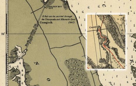
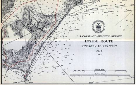 When Peter Swanson called to say he’d just become PassageMaker’s new editor-in-chief (which he’ll be great at, I think), the conversation soon turned to our strong mutual interests in cruising, electronics and charts. That’s how I finally learned that NOAA has started to remove the magenta chart lines that guide many users of the Intracoastal Waterway (ICW) and that they may never be replaced. Peter wrote about the issue in August, and NOAA recently put up a notably well-crafted Federal Register article that seeks more comments from the public. That’s where I learned that the brightly colored “recommended route lines” began on a 1913 chart series called the Inside Route Pilot — fascinating sample above, full size here — and that the lines haven’t been comprehensively updated since the 1930’s, when taxpayers spent a lot of money expanding the ICW (and creating jobs)…
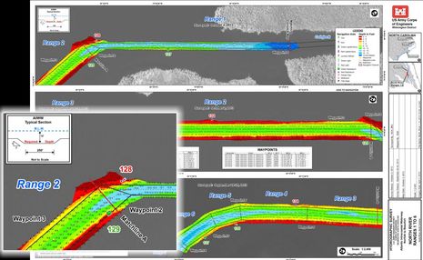 While I had no personal plans to use the ICW Magenta Line this season and I already know from experience that it does not always mark the best route, I’ll still miss it if it’s not on my charts when I head south again next fall (hopefully). So should NOAA remove it because it’s old and inaccurate, or spend a lot of money improving it, or is there another choice? The BoatUS site is loaded with relevant material and I was particularly struck by Bill Parletore’s recent Magenta musings in which he learned that responsibility for the Line somehow got lost between NOAA and U.S. Army Corp of Engineers (USACE), which now manages the Waterway. Then I found Tom Neale’s recent BoatUS entry which led me to interesting data like the above USACE survey of North Carolina’s North River.
While it’s heartening that much of the ICW — or AIWW in Corp speak — has been surveyed in such detail, isn’t it odd that there’s no reference whatsoever to the relevant NOAA charts?
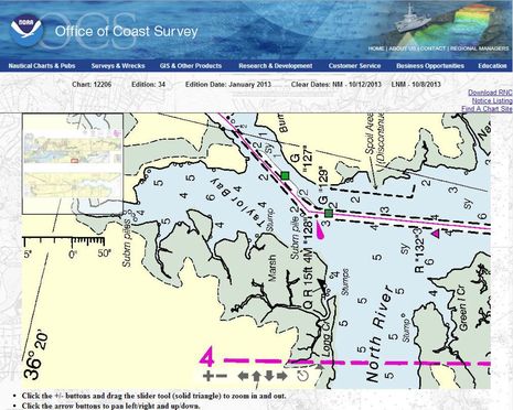 Well, above is the current Chart 12206 in NOAA’s online viewer and a detail I notice is how the Majenta Line favors G “129” and then runs well past Q R “128” while the USACE survey doesn’t at all suggest those nuances. The scales are obviously very different, but couldn’t there be some efficient way to get timely use of the Corp’s excellent data into our electronic navigation tools?
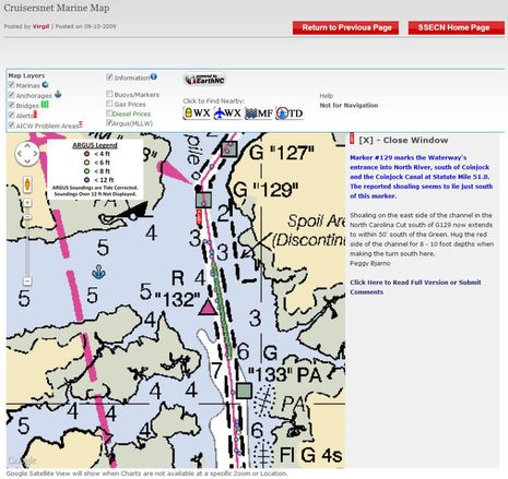 Of course, there are several crowdsourcing projects at work on this problem, like the Survis Argus depth data seen overlaid on the Cruisersnet online chart above (where there’s another Magenta Line conversation happening). I guess I understand why NOAA won’t accept Argus as “valid” data — which was Survice’s original hope (Panbo discussion here) — but again, wouldn’t it be nice if the soundings info was available in other ways?
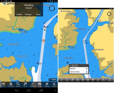 Like the Cruisersnet Alert seen above, there’s an ActiveCaptain Hazard marker for the area just south of R 128 turn. Its details and the 13 related comments (as recent as late August) are available in many charting apps, including the Android version of Jeppesen Plan2Nav. Note the Plan2Nav C-Map doesn’t show the Magenta Line, but I suspect that’s just a temporary glitch as it shows up fine (though in black) on the iOS version (note also the real life screen resolution difference between a Nexus 7 and an iPad mini, though the mini screen is larger). Note also how both Cruisersnet and AC have good information on anchoring well into the North River, a lovely spot I enjoyed in April.
But I chose this North River example in a pretty random fashion — it was one of the first Corp surveys I downloaded — and thus, it seems even more interesting that the “shoaling” problem may really be more of a charting problem. The ACE survey suggests that there would be no real issue here (for vessels drawing less than 8 feet) if the dredged channel and nav aids were charted more accurately.
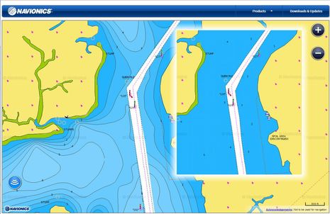 I also checked out this area via the online Navionics Webapp (which won’t let me link to a specific place, but is wicked fast). The main screen shows the chartmaker’s newish SonarCharts, which purportedly include the various bathymetric data sets that used to be called Fish N’ Chip, along with the boater-submitted soundings that were first called UGC 3D when we first discussed them in 2012. As best I can tell there’s not much user data in SonarCharts yet, but I know that Navionics is working hard on the issues of data compatibility and easy uploading. Wouldn’t it be neat if you could flip from the regular Navionics chart view (that’s inset above and faithful to the NOAA equivalent) to a SonarChart that showed what recent depth sounders had seen inside and outside the “dredged” channels?
I’m also hopeful that one day we’ll have chartplotters so powerful that while calmly cruising the North River we can open a window on, say, NOAA Historical Chart 1229, which shows that our 1913 forebearers had at least a little more information than the Inside Route chart that begins this entry. (Partial app solution discussed here.) But I’m not yet sure what I say to NOAA about the Magenta Line. While I definitely agree with the many cruisers who find the Line to be a useful general indication of where the ICW runs, especially when it crosses large water bodies or intersects with other channels, I’m not sure I want many tax dollars spent when we users are getting better ways to collect and share data. I hope you’ll share your thoughts here and with NOAA.


While I have always told people not to take the magenta line as Gospel, I would miss seeing it on ICW charts. It is useful to help quickly identify the ICW channel in areas where multiple channels converge or in areas where you are crossing a larger, more-open body of water like Albemarle Sound. Frankly, most of the ICW channel has adequate depths for most of the boats using it. So as long as you stay between the markers you are fine. Of course, there are shoaled-in areas, but they also tend to be the areas where depths change rapidly and frequently. I doubt any charting agency could stay ahead of the constantly shifting shoals 100%. You’ll note that even when there is a known shoal spot, with many people commenting on where the shoal is and where the deep water is, there is often deep disagreement about the information. Sometimes just a few feet one way or the other will put you aground or afloat–a distance that would be invisible if it was plotted on a chart and might even be missed by a line of Argus soundings.
I love the prospect of allowing the line to be adjusted ongoing by the new technologies available — especially as they continue being developed. Meanwhile, I have been advocating for NOAA to leave it as is, or, better yet, replace the sections that we all know are incorrect or change frequently with a “dashed line.” My email to NOAA Coast Survey follows:
*********************
For many who have cruised any of the three U.S. Intracoastal Waterways regularly, the Magenta Line has been a permanent fixture on every paper chart, chartbook, electronic chart and guidebook. It has been blamed for the grounding of many vessels, and it’s been praised for helping other skippers find their way in “good water.” Views have been expressed by boaters on several cruising sites, ranging from “skippers should learn how to navigate without the line,” to “if there is no magenta line, boaters will get lost in the inlets, sounds, or creek systems.”
Now, my two cents: I think that removing the Magenta Line will cause many more groundings. (This is my personal opinion and does not necessarily match the opinions or policies of Waterway Guide, or its management or other editors.)
A skipper should know better than to blindly follow any single “input” – and certainly should follow what the nav aids and the water is telling him/her. I think that skippers treat the line as the “general route” rather than a specific path — or at least do so after calling TowBoatUS a couple times. However, in most sections, the Magenta Line correctly depicts the navigable channel as it has been for decades. It also shows an arcing route from nav aid to nav aid where appropriate. A little research in any guidebook or cruiser’s website will alert boaters to the problem spots, and the charts could also depict these problem and shifting areas with a dashed line. (If you were following the Magenta Line on your chart and it changed into a dashed line, wouldn’t you say “hmmm…I wonder why it’s dashed here.)
It would be great if every skipper knew exactly what they were doing all of the time, but the ICWs are really the proving grounds for new cruisers – and the monotony can throw even old salts off their guard. Without the Magenta Line, many skippers will “miss the turn” — perhaps steering the vessel to a dangerous ocean inlet, or just up the wrong creek…one that’s likely not ever surveyed or dredged, and certainly not monitored by the cruising community. Getting stuck far off the beaten path can mean long delays in getting assistance, especially from other cruisers — but also from tow services. (The navigation aids (markers/buoys) have tiny, easy to miss triangles and squares to denote the ICW route, but the charts do NOT — no indication at all if the Magenta Line were to be removed.)
I am also concerned that the removal of the Magenta Line may lower the already low priority of maintaining many sections of the ICW, especially in an environment of reduced federal and state funds competing with an urgent need for the deepening and maintenance of commercial channels to accommodate “Post-Panamax” cargo vessels.
****************************************
So, please read the notice and be sure to register your opinion with the Coast Survey whether you think the Magenta Line should stay or go. Either way, it is very important for the boating public, trade groups, businesses, advocacy groups, and municipalities along the waterway to join together to help our representatives understand how much the ICW means to us, and the economies of these towns, states, and the nation. This historical waterway should be maintained for posterity, and should no longer be treated as an ad-hoc project without clear jurisdiction or priority.
Here’s the official notice: ( https://www.federalregister.gov/articles/2013/09/26/2013-23440/intracoastal-waterway-route-magenta-line-on-noaa-nautical-charts ).
Please send your comments by December 26 to NOAA Coast Survey at [email protected]. Thanks!
Hello Ben
Chetco Digital has the answer to this situation up and running. We displayed a demo of our cloud based, crowd sourcing product offering at the Connect World display at IBEX as well as at the NMEA convention in San Diego.
Since our wireless NMEA 2000 interface module is a ‘Plug and Play” NMEA 2000 compatible product we take all the data on the NMEA backbone and pump it to secure cloud servers. From here we are able to provide real time bottom mapping as well as other data which is valuable to mariners. Data not only being bottom soundings but also currents, true wind direction, AIS, water temps, pitch and roll and YES even real time accurate tidal information based on soundings taken within minutes. We also are developing and will have ready in only a few weeks a social network which will allow vessels of similar characteristics to share experiences such as maintenance history, engine performance history and other common history of operation of their vessel in real time as well as logged histories. Individual pieces of data can be selected as shared to be used by all mariners or private depending on personal choice.
This system has been under field trials with the USCG for over 6 months with outstanding success.
We make this all available for a few hundred dollars at the most. We are working with selected mapping companies who are using our firmware to enhance their product offerings.
Imagine real time bottom mapping of the Mississippi showing sandbar movement and development as they happen. Or imagine real time channel data showing cross chop, cross wind, shoaling etc. for river mouths or intercoastal waterway.
We have been doing this for almost 2 years and now have committed to commercially marketing it.
Being an open platform we welcome all interest from all levels from APP developers, boat builders, harbor masters, NOAA, marina’s and individuals.
Thanks for bringing this to the forefront. The technology exists and it exists are a very reasonable price.
Steve James
Chetco Digital
Thanks, Mike. I like your comment to NOAA including your idea of using a dashed line where the recommended route is uncertain (if NOAA can make that change without a lot of trouble).
And thanks, Steve. I was impressed with Chetco’s ConnectWorld exhibit at IBEX and plan to write an entry about it. It will certainly include the new PushSmart aspect of SeaSmart, which readers can check out here:
http://www.seasmart.net/marine-wireless-networking-WebSites.html
I’ve fooled around a bit with submitting track/sounder files to Navionics and have also looked at the similar features of Navico’s Insight Genesis. The aims of both projects are great, I think, but hardware compatibility is limited and actually saving the files and later uploading them is tedious. So I love the idea of a third party system that collects all the data in a standard format and automatically sends it the cloud whenever the boat is online. Good stuff!
Beyond the end of the magenta line, the more sobering news I learned today is that NOAA has announced that they are discontinuing the production of traditional paper charts. For someone whose navigational education was founded on parallel rules, dividers and a 3H pencil this truly seems to mark a phase-shift in modern navigational. I love my computer-based charts, but I’m comforted even more that I have paper on board and know how to use it. As the following article notes, the availability of paper charts is not completely dead, but they certainly won’t be available at every local chandlery anymore: http://www.noaanews.noaa.gov/stories2013/20131022_nauticalcharts.html
Ben, I like the magenta line, but I would never encourage someone zooming in on the MFD, and keeping their boat dead on the line expecting to be safe in all circumstances. It is good however for letting your eye quickly see the general path of the channel. By implication does this now mean that night navigation in straight lines from flashing mark to flashing mark is not as safe as it used to be? It’s also generally following the magenta line.
I know ICW maintenance isn’t what it used to be, but not every one has access to crowd sourced data from multiple sources yet. Maybe in the short run the problem areas could be physically flagged, ie one mark ahead. It’s like the highway department sticking a sign on the road warning of flooding, potholes, rock slide, lemmings crossing, or severe shoaling ahead.
What is the average accuracy of GPS? We have all seen the little boat on the screen merrily moving along the chartplotter well outside the charted channel while our Mark I eyeballs keep the real boat in the Waterway. Zooming in on the magenta line on your chart plotter gives you a false impression of accuracy. Here’s is some of what the government says about this issue from here: http://msi.nga.mil/MSISiteContent/StaticFiles/Files/NautChrts_GPS_index.htm
CHART ACCURACY
Specified Chart Accuracy. The NGA-specified accuracy standard for harbor, approach, and coastal charts is that features plotted on a chart will be within 1 mm at chart scale with respect to the datum, at a 90 percent confidence level. For a chart of 1:15,000 scale, a 1 mm error equates to � 15 meters (16.2 yards) on the real earth, which is of the same order of magnitude as the absolute GPS error. For a smaller scale chart of 1:80,000, the chart error is � 80 meters (86.4 yards), which is therefore the limiting factor in position plotting accuracy. The reverse can be true for large-scale (small area) charts, such as a harbor plan inset at 1:5,000 scale. In this case, the navigator’s plotting accuracy is limited by the absolute accuracy of GPS, rather than the chart; however, features on this chart should be accurate to � 5 meters.
Cartographic Presentation. “Cartographic license” may also be a factor. When depicting two or more closely spaced features on a chart, the chart maker may displace one feature slightly so the symbols do not overlap. This adjustment will normally keep the feature within the limit of 1 mm plotting accuracy.
Positioning of Survey Data. Errors in the underlying hydrographic survey data will also affect accuracy. While NGA makes every effort to produce the most accurate chart possible given the available data, the prudent navigator should pass shoals or isolated dangers with utmost caution, no matter what navigation method is used. Few coastal surveys of years past were possible to differential GPS accuracies, and shoals may have moved significant distances since the surveys were done.
Pencil Width. Although seemingly trivial, the width of a pencil line becomes a significant source of error at some scales. At 1:15,000, the 0.5 mm line width of a mechanical pencil lead equates to 7.5 meters (8.1 yards) on the chart. At 1:80,000, the same pencil line width equates to 40 meters (43.2 yards) on the chart. Thus a dull pencil can become the largest source of error, and thus the standard of accuracy, in the use of the chart.
Good news regarding ICW charts and Magenta Line! NOAA is going to improve it as an “advisory directional guide” (though it will take several years). Details here:
http://www.nauticalcharts.noaa.gov/staff/news/2014/magenta.html
What’s more the NOAA cartographers will now be using user-generated data from ActiveCaptain “for Intracoastal Waterway chart analysis” in addition to the direct reports from individual boaters and the Power Squadron they’ve long used. See announcement toward bottom here:
http://www.sailingbreezes.com/Sailing_Breezes_Current/Articles/jan14/coast-survey-to-improve-magenta-line-on-intracoastal-waterway-nautical-charts.html