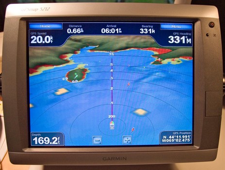
Garmin 5212, sexy time!

Um, speaking of 3D (and one very funny man), I just unpacked and powered up a 5212 and…wow! On first impression I’d say its touch screen control is as smooth and responsive as Maptech’s latest i3 (and that’s saying something). And weren’t there some nice surprises during my first hour. I’m not sure I’m ready to navigate without spot soundings, but Garmin’s Mariner’s Eye 3D (g2 Vision card required) is darn close. Note, bigger picture here, how you can specify hot colors for the hazardous areas. (The ledges at about .4 miles, two o’clock, should show hotter, but maybe that’s just a local glitch. Will check.) Note too the yellow botches of radar overlay; they’re just a simulation here but I’d sure like to see how they work in reality. (I was monitoring VHF as I tested this unit in the lab. Maine’s blanketed in a dungeon fog this evening, but AIS shows the Cat still doing almost 40 knots offshore; it’s hairy out there!). But what really surprised me is that the two lit navigation aids to Camden were graphically showing their characteristics in this 3D mode (see the green dot over Curtis Island to port). I didn’t even know Garmin had “borrowed” that C-Map Max feature. Now all this may apply to Mariner’s 3D on every new Garmin unit, but the screen below certainly doesn’t. Note the very large touch keys, and note how they’re grayed out when they don’t apply to a particular data field. So easy to use; so sexy time!


For more info on this network capable chartplotter including how the software upgrades over the last year have improved things see our review at:
http://www.marine-electronics-reviews.com/garmin-5212.html
Al