
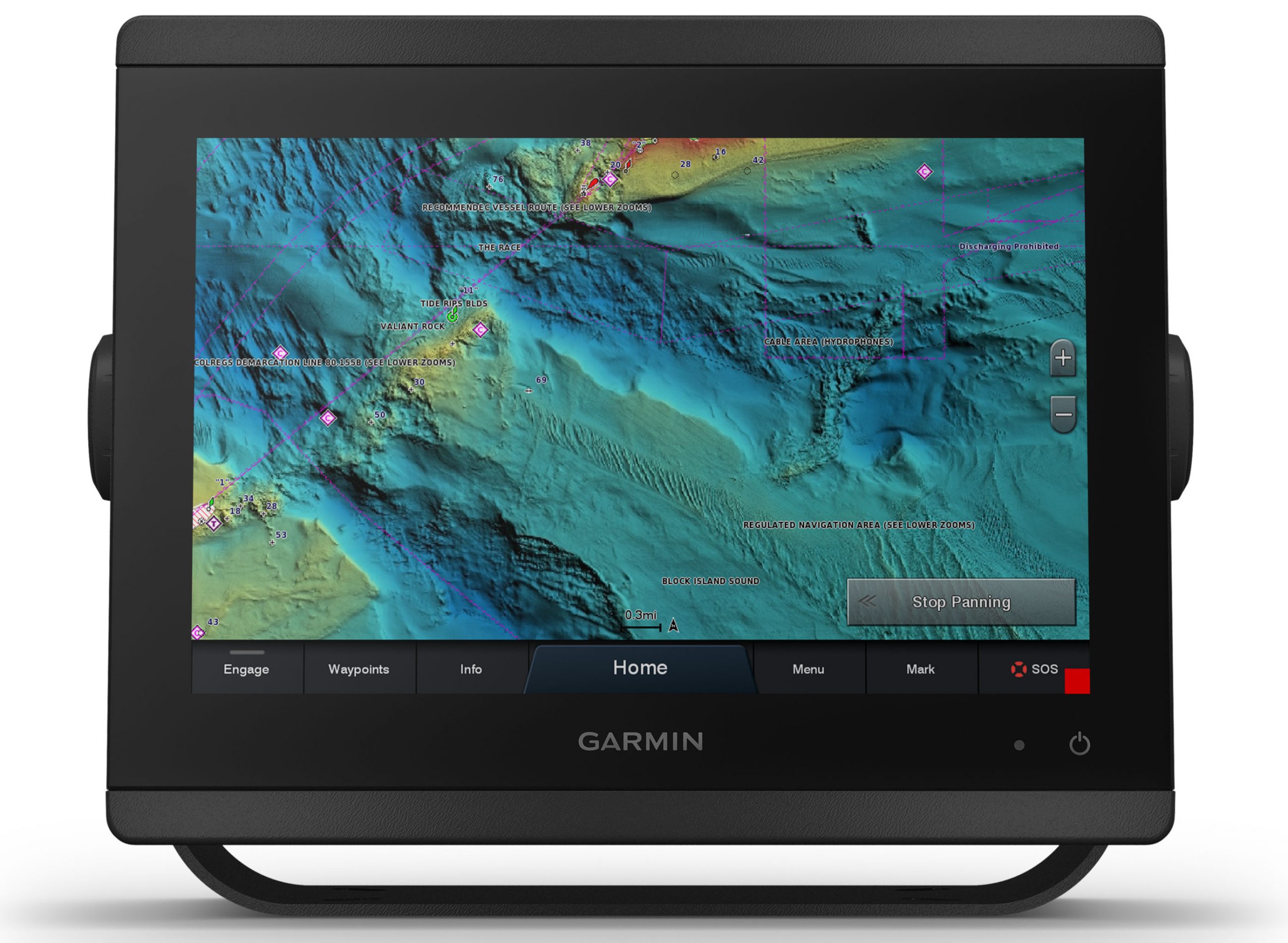
Garmin adds high-resolution relief shading to its premium BlueChart g3 Vision and LakeVü g3 Ultra cartography
Garmin high-resolution relief shading BlueChart g3 Vision
New charts and maps offer unrivaled detail and enhancements
OLATHE, Kan./Feb. 13, 2019 — Garmin International, Inc., a unit of Garmin Ltd., today announced that it has added high-resolution relief shading to its
exclusive BlueChart g3 Vision and LakeVü g3 Ultra cartography products for coastal and inland fishing and boating. High-resolution relief shading brings an entirely new level of detail to the ocean floor and lake bottom, making it easier than ever to find structure, artificial reefs, underwater shelves and more – the kind of detail anglers and divers depend on.
With industry-leading coverage, clarity and detail, Garmin’s new g3 cartography blends the best of both Garmin and Navionics content together, and offers enhancements like built-in Auto Guidance1 technology that searches through relevant charts to create a suggested route based upon the user’s desired depth and overheard clearance. For mariners who want the most feature-rich data available, the premium BlueChart g3 Vision and LakeVü g3 Ultra accessory cards and downloads include everything available with g3, and now for the first time, add high-resolution relief shading that combines color and shadow to give mariners an easy-to-interpret, clearer view of bottom structure than contour lines alone. Garmin’s high-resolution relief shading is available with coverage for U.S. coastal waters – east coast, west coast and Gulf of Mexico – along with more than 150 Garmin-surveyed lakes.
“The recent upgrades we’ve made to our g3 cartography products – more detail, dimension and routing sophistication – is a true testament to our long-standing commitment to continually improving our cartography to give our customers the highest quality and most detailed, accurate charts and maps on the water today,” said Dan Bartel, Garmin worldwide vice president of consumer sales. “We’re excited to offer high-resolution relief shading to our premium BlueChart g3 Vision charts and LakeVü g3 Ultra maps and look forward to continuing to bring even more detail to our customers.”
The new Garmin g3 cartography products brings unrivaled detail and convenience to users with navigational aids, spot soundings, depth contours, tides and currents, and detailed harbors and marinas. The data offers seamless chart presentation with up to 1-foot fishing contours that provide a more accurate depiction of bottom structure for improved fishing charts and enhanced detail in canals, marinas and port plans. Raster cartography that gives the chartplotter paper-chart like views of NOAA nautical charts, has also been added to the new g3 cartography product line and is available as a free downloadable feature via the Garmin ActiveCaptain® app.
In addition to high-resolution relief shading, BlueChart g3 Vision also includes high-resolution satellite imagery that provides the user with a realistic view of their surroundings. Unique 3-D views, including MarinerEye and FishEye, provide additional perspective both above and below the water line, and aerial photography shows exceptional detail of many ports, harbors and marinas, which is especially useful when entering unfamiliar ports. For inland customers, LakeVü g3 Ultra includes maps of more than 17,000 lakes with up to 1-foot contours. Of those, over 150 are Garmin Elite surveyed lakes with high-resolution satellite imagery, multi-beam sonar views shore-to-shore, side scan photos and photos of notable spots above the water too.
The new BlueChart g3 Vision and LakeVü g3 Ultra accessory cards and downloads vary in price from $249.99 to $349.99 and will be available with high-resolution relief shading in Q2 2019. At this time, high-resolution relief shading and raster charts are only available for the U.S. Availability for other regions is expected in Q4 2019. To learn more, visit garmin.com/maps.
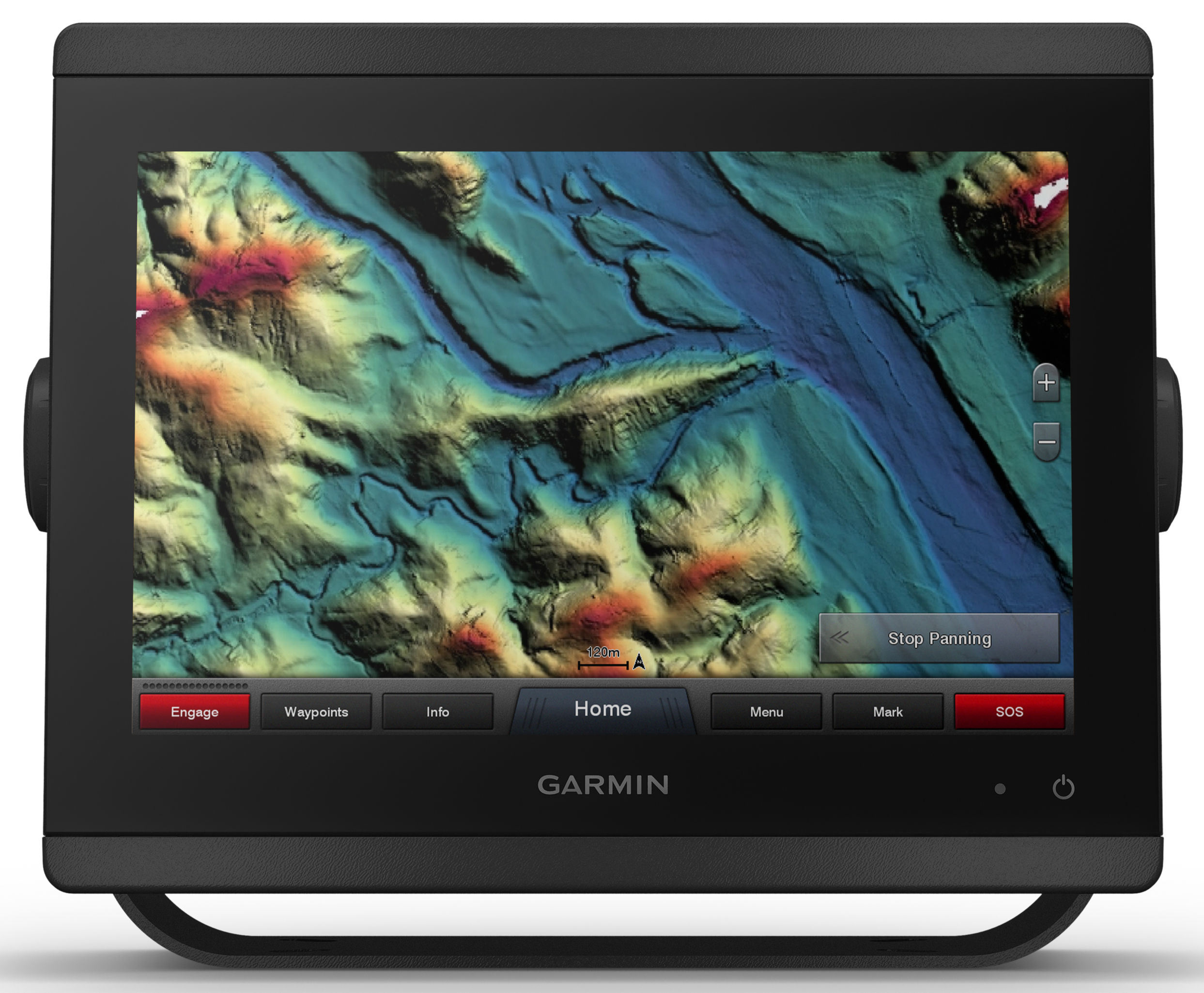
Garmin high-res relief shading LakeVu g3 Ultra
Related Posts:


Panbo publishes select press releases as a service to readers and the marine electronics industry. The release contents do not reflect the opinion of the editors and are not fact checked by the editors


The new G3 relief maps look gorgeous in the images, but there is one aspect of the transition from G2 to G3 that may upset some Garmin chart users in the Bahamas. On all G3 charts either purchased or embedded in new MFDs, Navionics data for the Bahamas will purportedly replace Explorer Chart data:
https://explorercharts.com/chatter/big-changes-in-explorer-electronic-data-availability/
I’ve always been a bit skeptical about what some cruisers say are major quality differences between Navionics and Explorer in the Bahamas, but it is an unusual place because there is no official hydrographic office updating charts.
At any rate, I may write about this change and I’m looking for places where I might see significant differences between the Explorer and Navionics Bahamas charts I have on various apps and plotters. Please email editor at panbo.com
I asked Ken Cirillo about replacing Explorer Charts with Navionics. He said Garmin made the decision because they believe Navionics data for the Bahamas is as good or better than what they’re getting from Explorer Charts. Additionally, Navionics has very well developed systems for making corrections and invests heavily in keeping their charts current.
I also had the chance to see an 8600 MFD with G3 running with raster charts displayed. The charts looked great and it’s very nice to see Garmin supporting Raster charts. Ken did give Ben E. some credit for championing the support of raster charts.
Ben S.
It would be nice if Garmin would stop announcing these products and actually released them. Just checked Active Captain, and they are not yet available. Garmin website says “available Feb 2019”. The trend seems to be getting worse among the various manufacturers. Guess I’m still smarting from the Standard Horizon GX6500 debacle.
It should be noted that there is a very substantial cost difference between G3 and
G3Vision charts. For the US east coast it is
over $1000. If you are an angler that may make sense but for a cruiser mainly interested in navigation and auto routing – probably not. Look for the G3 offering “All US and Canada West Coast”. Kinda confusing but “all US” is not. It is widely available now from the many o/l discounters.